COLLECTION NAME:
David Rumsey Historical Map Collection
Record
Author:
Woodbridge, William C.
Date:
1845
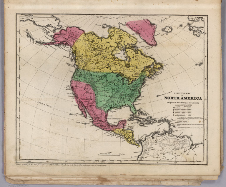
Short Title:
Political Map Of North America
Publisher:
Belknap and Hamersley
Publisher Location:
Hartford
Type:
Atlas Map
Obj Height cm:
25
Obj Width cm:
31
Scale 1:
4,500,000
Note:
Full color map. Includes References and Explanations, showing Cities, Inhabitants, Capital of Countries, Trading houses or Ports, Indian Villages and Missionary Stations, Figures indicate the Rrank of Rivers and Mountains. Covers are heavy brown paper printed with "School Atlas, To Accompany The Modern School Geography, By William C. Woodbridge ... Hartford: Published By Belknap & Hamersley. Entered ... 1843, by William C. Woodbridge ... Massachusetts. Case, Tiffany & Co. Printers, Hartford, Conn." prime meridian is Greenwich. Relief shown by hachures.
World Area:
North America
Subject:
School
Subject:
Political
Full Title:
Political Map Of North America. Adapted To Woodbridge's Geography. Entered ... 1843, by W.C. Woodbridge ... Massachusetts. Hartford. Published By Wm. Jas. Hamersley. (to accompany) Modern Atlas, Physical, Political And Statistical; Exhibiting On Separate Maps ...
List No:
1229.009
Series No:
9
Engraver or Printer:
Atwood, J.M.
Engraver or Printer:
Story & Atwood
Engraver or Printer:
Williams, W.
Engraver or Printer:
Pelton, C.
Engraver or Printer:
Case, Tiffany & Co.
Publication Author:
Woodbridge, William C.
Pub Date:
1845
Pub Title:
Modern Atlas, Physical, Political And Statistical; Exhibiting On Separate Maps, The Physical And Political Characteristics Of Countries, The Prevailing Religions, Forms Of Government And Degrees Of Civilization, The Climates And Productions Of The Earth, And The Comparative Size Of Countries, Towns, Rivers And Mountains; Accompanied By Geographical And Statistical Tables. By William C. Woodbridge ... Entered ... 1843, by W.C. Woodbridge ... Massachusetts. Hartford. Published By Belknap And Hamersley.
Pub Note:
Physical maps and Political maps. Maps by J.M. Atwood, W. Williams, C. Pelton. Maps are without color or hand painted in full and outline color. Covers are heavy brown paper printed with "School Atlas, To Accompany The Modern School Geography, By William C. Woodbridge ... Hartford: Published By Belknap & Hamersley. Entered ... 1843, by William C. Woodbridge ... Massachusetts. Case, Tiffany & Co. Printers, Hartford, Conn."
Pub List No:
1229.000
Pub Type:
School Atlas
Pub Maps:
19
Pub Height cm:
31
Pub Width cm:
25
Image No:
1229009
Authors:
Woodbridge, William C.