COLLECTION NAME:
David Rumsey Historical Map Collection
Record
Author:
Thompson & West
Date:
1878
Short Title:
Alameda Co. 5.
Publisher:
Thompson & West
Publisher Location:
Oakland
Type:
Atlas Map
Obj Height cm:
45
Obj Width cm:
67
Scale 1:
31,680
Note:
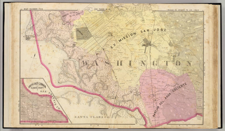
Hand col. lithographed map. Relief shown by hachures. Covers Newark and part of Fremont. Shows parcels with owners, tracts, etc. Inset map: South east corner of Alameda County.
State/Province:
California
County:
Alameda County (Calif.)
City:
Fremont (Calif.)
City:
Newark (Calif.)
Full Title:
Map number five (Alameda County farm map. Published by Thompson & West, Oakland, Cala, 1878)
List No:
0999.017
Page No:
44-45
Series No:
20
Publication Author:
Thompson & West
Pub Date:
1878
Pub Title:
Official and historical atlas map of Alameda County, California. Compiled, drawn and published from personal examinations and surveys by Thompson & West. Oakland, Cala. 1878. Thos. Hunter Pr. Phila. N. Friend, Engr. Philad. C.L. Smith, Del.
Pub Reference:
Phillips, 1460; LeGear. Atlases of the United States, L 460.
Pub Note:
Illustrated title page. Impressive maps and views of Oakland, Alameda, Berkeley and other more obscure parts of the county. Full color. Bound in three quarters leather brown cloth covered boards with "New historical atlas of Alameda Co. California. Illustrated. Thompson & West. 1878." stamped in gold.
Pub List No:
0999.000
Pub Type:
County Atlas
Pub Maps:
36
Pub Height cm:
45
Pub Width cm:
39
Image No:
0999017
Authors:
Thompson & West
Collection:
Rumsey Collection
Alameda Co. 5.