Detail View: David Rumsey Historical Map Collection: North Atlantic Ocean.
|
Author:
|
Blunt, Edmund M. (Edmund March), 1770-1862
|
|
Date:
|
1835
|
|
Short Title:
|
North Atlantic Ocean.
|
|
Publisher:
|
E. & G.W. Blunt.
|
|
Publisher Location:
|
New York
|
|
Type:
|
Chart Map
|
|
Obj Height cm:
|
93
|
|
Obj Width cm:
|
124
|
|
Scale 1:
|
8,000,000
|
|
Note:
|
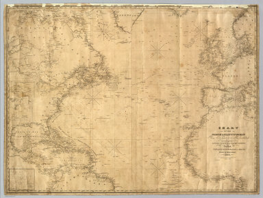
An uncolored, bluebacked chart with three insets, top to bottom: Georges Shoals, Nantucket South Shoal, The Virgin Rocks and the surrounding Bank from recent surveys. Lines of travel and notes written on the map in pencil.
|
|
Reference:
|
Not in Guthorn; cf P3661.
|
|
World Area:
|
Atlantic
|
|
Full Title:
|
Chart Of The North Atlantic Ocean, From the Equator to 65° North Latitude. According to the Latest Surveys & Observations. New York, Published by E. & G.W. Blunt, 154 Water St. Corner of Maiden Lane. 1832. Entered ... 1832, by Edmund & George W. Blunt ... New York. Additions to 1835. Engraved by W. Hooker. Lettered by D.R. Harrison. (with) three inset maps listed in Notes.
|
|
List No:
|
4611.000
|
|
Engraver or Printer:
|
Harrison, D. R.
|
|
Engraver or Printer:
|
Hooker, William
|
|
Publication Author:
|
Blunt, Edmund M. (Edmund March), 1770-1862
|
|
Pub Date:
|
1835
|
|
Pub Title:
|
Chart Of The North Atlantic Ocean, From the Equator to 65° North Latitude. According to the Latest Surveys & Observations. New York, Published by E. & G.W. Blunt, 154 Water St. Corner of Maiden Lane. 1832. Entered ... 1832, by Edmund & George W. Blunt ... New York. Additions to 1835. Engraved by W. Hooker. Lettered by D.R. Harrison. (with) three inset maps listed in Notes.
|
|
Pub Reference:
|
Not in Guthorn; cf P3661.
|
|
Pub Note:
|
See note field above.
|
|
Pub List No:
|
4611.000
|
|
Pub Type:
|
Chart Map
|
|
Pub Height cm:
|
93
|
|
Pub Width cm:
|
124
|
|
Image No:
|
4611000
|
|
Download 1:
|
|
|
Download 2:
|
|
|
Authors:
|
Blunt, Edmund M. (Edmund March), 1770-1862
|