Detail View: David Rumsey Historical Map Collection: New York City and Vicinity.
|
Author:
|
Walling, H. F.
|
|
Date:
|
1863
|
|
Short Title:
|
New York City and Vicinity.
|
|
Publisher:
|
S.D. Tilden
|
|
Publisher Location:
|
New York
|
|
Type:
|
Wall Map
|
|
Obj Height cm:
|
160
|
|
Obj Width cm:
|
160
|
|
Scale 1:
|
30,000
|
|
Note:
|
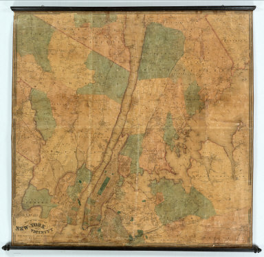
2nd edition. 1st was 1860 (NY and its Environs). Many changes from the 1860 edition - more roads, subdivisions, etc. Later editions in 1864, 1866 and 1869. This copy is the 1st edition to say "New York and its Vicinity." Extends northward from New York City 29 miles and southward 2 miles, which is shown with circles. Walling published another version of this map in 1863 (Haskell 1121) that includes all of Staten Island (this copy shows none of Staten Island) but extends north only to Englewood (see our 1860 issue of New York and Its Environs which covers the same territory). Prime meridian New York City Hall. Shows innumerable rural strudtures with owner names, water features, roads, railroads, and mileages from City Hall.
|
|
Reference:
|
Haskell 1120.
|
|
City:
|
New York (N.Y.)
|
|
Full Title:
|
Map of the City of New-York and Its Vicinity From Actual Surveys Made Under the Direction of H.F. Walling. Published by S.D. Tilden, 36 Dey St., New York, 1863.
|
|
List No:
|
2882.000
|
|
Publication Author:
|
Walling, H. F.
|
|
Pub Date:
|
1863
|
|
Pub Title:
|
Map of the City of New-York and Its Vicinity From Actual Surveys Made Under the Direction of H.F. Walling. Published by S.D. Tilden, 36 Dey St., New York, 1863.
|
|
Pub Reference:
|
Haskell 1120.
|
|
Pub Note:
|
See note field above.
|
|
Pub List No:
|
2882.000
|
|
Pub Type:
|
Wall Map
|
|
Pub Height cm:
|
160
|
|
Pub Width cm:
|
160
|
|
Image No:
|
2882000
|
|
Download 1:
|
|
|
Download 2:
|
|
|
Authors:
|
Walling, H. F.
|