COLLECTION NAME:
David Rumsey Historical Map Collection
Record
Author:
Berghaus, Heinrich
Date:
1841
Short Title:
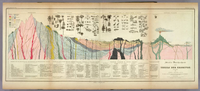
Idealer Durchschnitt eines Theils Der Erdrinde.
Publisher:
Justus Perthes
Publisher Location:
Gotha
Type:
Geologic Cross-Section
Obj Height cm:
33
Obj Width cm:
81
Note:
A full color "ideal" geologic cross section with a detailed key explaining all of the notations on the map. Above the section are numerous drawings of plants, animals, and sea life.
Reference:
cfP215; cf Sabin 4856; Robinson "Early Thematic Mapping" p 65-67; Espenhorst 2.7.
Subject:
Geology
Full Title:
Idealer Durchschnitt eines Theils Der Erdrinde. Verfafst von Thomas Webster, F.G.S. &c. Die Pflanzen und Thiere nach der Auswahl und Anordnung des Dr. Buckland gezeichnet von Joseph Fischer. Potsdam, gestochen in der geographischen Kunstschule, die Figuren von J.C. Ausfeld. 3te Abtheilung: Geologie, No. 11. Gotha, J. Perthes, 1841.
List No:
2515.038
Page No:
3.11
Series No:
43
Engraver or Printer:
Ausfeld, Johann Carl
Engraver or Printer:
Fischer, Joseph
Engraver or Printer:
Webster, Thomas
Publication Author:
Berghaus, Heinrich
Pub Date:
1849
Pub Title:
Dr. Heinrich Berghaus' Physikalischer Atlas oder Sammlung von Karten, auf denen die hauptsachlichsten Erscheinungen der anorganischen und organischen Natur nach ihrer geographischen Verbreitung und Vertheilung bildlich dargestellt sind ... 1845. Verlag von Justus Perthes in Gotha ... 1848 ...
Pub Reference:
cfP215; cf Sabin 4856; Robinson "Early Thematic Mapping" p 65-67; Espenhorst 2.7.
Pub Note:
Of the 90 plates, 75 are maps. 1st ed 2nd state,1845/1848 on titles, 1849 on some maps in volume one. 1st edition, 1st state was 1845/1848, with no maps dated later than 1848 (rare - WH). Second edition 1852 (see our copy). This is considered the first comprehensive physical atlas of the world. Robinson: "Berghaus' Physikalischer Atlas was a monumental achievement, bringing together an enormous amount of information about the physical geography of the earth and encompassing many more subjects than had been treated in the numerous smaller atlases that had been produced since the 1820's." In two volumes, the first dated 1845, the second 1848. A.K. Johnston's Physical Atlas of 1848 was based on this work. Maps are hand painted in full and outline color. Atlas volumes are bound in green cloth covered boards stamped in gold with "Berghaus' Physik. Atlas 90 Karten. I Band." and "... II Band." for volumes I and II, respectively. The spines read "Berghaus. I." and "Berghaus. II."
Pub List No:
2515.000
Pub Type:
World Atlas
Pub Maps:
75
Pub Height cm:
38
Pub Width cm:
26
Image No:
2515038
Authors:
Berghaus, Heinrich
Collection:
Rumsey Collection