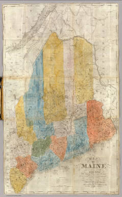
Detail View: David Rumsey Historical Map Collection: Map Of Maine.
|
Author:
|
Anson, W.
|
|
Date:
|
1843
|
|
Short Title:
|
Map Of Maine.
|
|
Publisher:
|
S.H. Colesworthy
|
|
Publisher Location:
|
Portland
|
|
Type:
|
Pocket Map
|
|
Obj Height cm:
|
60
|
|
Obj Width cm:
|
37
|
|
Scale 1:
|
950,400
|
|
Note:
|
Later edition published in 1853. One of the first separately published maps of the state after the treaty of 1842 settled the border with Canada. Folded into black leather covers 13x8 with "Map Of Maine." stamped in gilt.
|
|
Reference:
|
Smith/Greenleaf 88; Williamson 5835.
|
|
State/Province:
|
Maine
|
|
Full Title:
|
Map Of Maine Constructed from the most Correct Surveys With Sectional Distances and Elevations or Level, of the St. Croix River from Calais Bridge. Deduced from the States Survey, Made by W. Anson, Civil Engineer, In 1836. Engraved & Published by by S.H. Colesworthy, Portland. 1843. Revised Edition.
|
|
List No:
|
2964.001
|
|
Series No:
|
2
|
|
Engraver or Printer:
|
Colesworthy, S.H.
|
|
Publication Author:
|
Anson, W.
|
|
Pub Date:
|
1843
|
|
Pub Title:
|
Map Of Maine Constructed from the most Correct Surveys With Sectional Distances and Elevations or Level, of the St. Croix River from Calais Bridge. Deduced from the States Survey, Made by W. Anson, Civil Engineer, In 1836. Engraved & Published by by S.H. Colesworthy, Portland. 1843. Revised Edition.
|
|
Pub Reference:
|
Smith/Greenleaf 88; Williamson 5835.
|
|
Pub Note:
|
See note field above.
|
|
Pub List No:
|
2964.000
|
|
Pub Type:
|
Pocket Map
|
|
Pub Maps:
|
1
|
|
Pub Height cm:
|
13
|
|
Pub Width cm:
|
8
|
|
Image No:
|
2964001
|
|
Download 1:
|
|
|
Download 2:
|
|
|
Authors:
|
Anson, W.
|
|
Collection:
|
Rumsey Collection
|