Detail View: David Rumsey Historical Map Collection: Map Of Colorado Territory, Shewing The System Of Parks.
|
Author:
|
Ebert, Frederick J.
|
|
Author:
|
Gilpin, William, 1822-1894
|
|
Author:
|
Monk, Jacob
|
|
Date:
|
1865
|
|
Short Title:
|
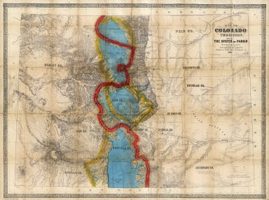
Map Of Colorado Territory, Shewing The System Of Parks.
|
|
Publisher:
|
Jacob Monk
|
|
Publisher Location:
|
Philadelphia
|
|
Type:
|
Pocket Map
|
|
Obj Height cm:
|
65
|
|
Obj Width cm:
|
87
|
|
Scale 1:
|
760,320
|
|
Note:
|
2nd edition. Wheat: "the first 'indigenous' (Colorado) map of importance...a truly imposing map, a credit to all who had a hand in it..." Rare. The 1st edition was published in 1862 with a different title (Map of the Colorado Territory, Embracing the Central Gold Region...) and coloring (it does not emphasize the system of parks) but the same topography and political delineation. This 1865 edition colors the parks in deep blue (they look like water) and the continental divide in bright red and yellow. Ellis lists this map under Monk, has the copyright which was issued in 1862 (when he published the first edition). Streeter mentions that the 1862 edition was the first separate map of Colorado and that it also appeared on a smaller scale (18 miles/inch) as an inset in the huge Pratt and Buell "Map of the Gold Regions in...Colorado Territory" of 1862. Wheat mentions and Phillips lists an 1866 issue of the 1862 map, with J.H. Colton as the publisher. To further complicate matters, our copy of the 1865 edition has covers 16x12 with a printed blue label saying "Monk's Map of Colorado Territory" (barely legible) and a paste down advertisement for "J.H. Colton's Geographical Establishment" on the inside front cover. So Colton was distributing the 1865 edition and then took over publishing the map in 1866. Gilpin wrote "The Central Gold Region" in 1860 with six maps, republished in 1873 with additions and titled "Mission of the American People," which had a map showing the system of parks in manner similar to this map.
|
|
Reference:
|
Wheat 1118; Ellis 40; Streeter 2164; cf P-Maps 241 (1866 ed.)
|
|
State/Province:
|
Colorado
|
|
Full Title:
|
Map Of Colorado Territory, Shewing The System Of Parks. Drawn by Frederick J. Ebert under direction of the Governor Wm. Gilpin. Published by Jacob Monk, Philadelphia, Pa. 1865. Thos. Sinclair's lith. Philada.
|
|
List No:
|
3509.001
|
|
Series No:
|
2
|
|
Engraver or Printer:
|
Sinclair, Thos
|
|
Publication Author:
|
Ebert, Frederick J.
|
|
Publication Author:
|
Gilpin, William, 1822-1894
|
|
Publication Author:
|
Monk, Jacob
|
|
Pub Date:
|
1865
|
|
Pub Title:
|
Map Of Colorado Territory, Shewing The System Of Parks. Drawn by Frederick J. Ebert under direction of the Governor Wm. Gilpin. Published by Jacob Monk, Philadelphia, Pa. 1865. Thos. Sinclair's lith. Philada.
|
|
Pub Reference:
|
Wheat 1118; Ellis 40; Streeter 2164; cf P-Maps 240 (1866 ed. of 1862 map).
|
|
Pub Note:
|
See note field above.
|
|
Pub List No:
|
3509.000
|
|
Pub Type:
|
Pocket Map
|
|
Pub Maps:
|
1
|
|
Pub Height cm:
|
16
|
|
Pub Width cm:
|
12
|
|
Image No:
|
3509001
|
|
Download 1:
|
|
|
Download 2:
|
|
|
Authors:
|
Ebert, Frederick J. ; Gilpin, William, 1822-1894 ; Monk, Jacob
|
|
Collection:
|
Rumsey Collection
|