
|
|
|
Map of the Missouri; of the higher parts of the Mississippi. Collot, George Henri Victor ; Tardieu, P.F. 1796
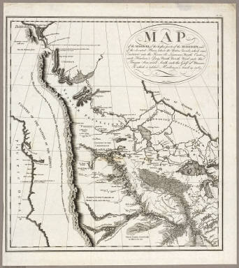 View larger, zoomable image (turn off pop-up blocker) Full Title: Map of the Missouri; of the higher parts of the Mississippi; and of the elevated Plain, where the Waters divide, which run, Eastward into the River St. Lawrence; North East into Hudson's Bay; North North West into the Frozen Sea; and South into the Gulf of Mexico. To which is added Mackenzie's track in 1789. PL. 29. Author: Collot, George Henri Victor ; Tardieu, P.F. Date: 1796 This historical cartographic image is part of the David Rumsey Historical Map Collection, www.davidrumsey.com, a large collection of online antique, rare, old, and historical maps, atlases, globes, charts, and other cartographic items. Read more about the Collection. Or you can view the entire David Rumsey Map Collection in Insight. Full David Rumsey Map Collection Catalog Record: Author: Collot, George Henri Victor ; Tardieu, P.F. Date: 1796 Short Title: Map of the Missouri; of the higher parts of the Mississippi. Publisher: Paris: Arthus Bertrand Type: Atlas Map Object Height cm: 49 Object Width cm: 45 Scale 1: 8,500,000 Note: This was the first map to show the results of the expedition of J.B. Trudeau from 1794 to 1796. It is also one of the most important late Eighteenth Century maps showing the Transmississippi West and is highly praised (and illustrated) by Wheat: "an important intermediate cartographic step between Soulard's highly rudimentary showing of the Missouri Basin, and the excellent charts of the river as far as the Mandan Villages drawn by McKay and Evans." Reference: P1214-29; Streeter 1789; Eberstadt 137-132; Buck 48; Sabin 14460; WC 31a:2a; Howes C601; Wheat 236; Karrow 1-1228. State / Province: U.S. West Full Title: Map of the Missouri; of the higher parts of the Mississippi; and of the elevated Plain, where the Waters divide, which run, Eastward into the River St. Lawrence; North East into Hudson's Bay; North North West into the Frozen Sea; and South into the Gulf of Mexico. To which is added Mackenzie's track in 1789. PL. 29. List No: 4664.019 Series No: 19 Published In: A Journey in North America, containing a Survey of the Countries watered by the Mississippi, Ohio, Missouri, and other Affluing Rivers; with Exact Observations on the Course and Soundings of these Rivers; and on the Towns, Villages, Hamlets, and Farms of that Part of the New World; followed by Philosophical, Political, Military and Commercial Remarks, and by a Projected Line of Frontiers and General Limits. Illustrated by an Atlas of 36 Maps, etc. By Gen. V. Callot, late in the French Service, and Governor of Guadeloupe. Publication Author: Collot, George Henri Victor ; Tardieu, P.F. Publication Date: 1796 Publication Reference: P1214; Streeter 1789; Eberstadt 137-132; Buck 48; Sabin 14460; WC 31a:2a; Howes C601; Wheat 236; Karrow 1-1228. Publication Note: This group of maps appears in Collot's "Journey in North America..." They are some of the earliest maps of the Ohio River valley (in great detail) and the Mississippi River valley. Sabin notes: "This work was printed both in French and English, but not published, at the time of General Collot's death, which happened in 1805. More than twenty years afterwards, the whole impression came into the hands of M. Bertrand...The journey was undertaken in 1796, at the request of Adet..." The work was published in 1826, but engraved and printed in 1805 based on a journey in 1796. The strange delay in publishing is explained best in Wagner Camp. The atlas and two text volumes are superlatively rare (Howes "dd", Eberstadt: "extraordinarily rare"). Publication List No: 4664.000 Publication Type: National Atlas Publication Maps: 22 Image No: 4664019
Important!
The Insight® Browser and Java client software are products of Luna Imaging, Inc. If you have comments, suggestions, or need help, contact The David Rumsey Collection at home | about | view the
collection | recent
additions | news | help |
