Author
[Colton, J. H., Creuzbaur, Robert, De Cordova, Jacob]
Full Title
J. De Cordova's Map Of The State Of Texas Compiled from the records of the General Land Office of the State by Robert Creuzbaur, Revised and Corrected by Charles W. Pressler. Published by J.H. Colton & Co. No. 172 William St. New York 1856. Engraved by J.M. Atwood, New York. Entered ... 1856 by J. De Cordova ... Texas. (with untitled inset of southwestern U.S.).
List No
3366.001
Note
First edition of Pressler's revision of De Cordova's map, and first edition published by Colton. Shows Texas east of the 102nd meridian. First issued by De Cordova in 1849, with editions of 1850, 51, 53, 56, 57, 58, and 61 (Ristow and Rosenberg), and a late unlisted edition in 1867 (see our #4801). De Cordova employed Pressler to revise the map in 1855 and then sold the rights to Colton in the same year. The 1849 edition has only two copies located. Eberstadt called the 1849 issue "possibly the finest (Texas map) of the period." Colton changed the inset map from the oval showing all of Texas to the southwestern portion of Colton's U.S. atlas map. J.M. Atwood was the engraver of all editions. With a list of the Land districts, this map was useful for both land promoters and settlers. Colton published a reduced version of the map in his 1856 Atlas of the World. The full color map is folded into stamped dark maroon leather covers 16x10.5 with "J. De Cordova's Texas J.H. Colton & Co. New York." in gilt.
Author
Hayes, Eli L.
Full Title
(Title Page to) Illustrated atlas of the Upper Ohio River and Valley from Pittsburgh, Pa. to Cincinnati, Ohio. From United States official and special surveys compiled & drawn for the publishers by E.L. Hayes, assisted by E.F. Hayes, C.M. Beresford, assisted by S.A. Charpiot, F.L. Sanford, J.H. Sherman. Published by Titus, Simmons & Titus, 27 South Sixth Street Phila. 1877. Eng. by Worley & Bracher, 27 So. Sixth St. Phila, Pa. Printed by H.J. Toudy & Co. 623 Commerce St. Phila, Pa. Oldach & Mergenthaler Binders, S.E. Cor. 4th & Cherry Sts. Phila. Entered ... 1877, by Titus Simmons & Titus ... Washington. (view by) A. Ruger, del ...
List No
4975B
Note
Includes "View on the Ohio River taken from near East Liverpool, embracing parts of Ohio, West Virginia & Pennsylvania, A. Ruger del." This is perhaps the most extraordinary "county atlas" produced in the 19th century. Although it is a regional atlas in scope, covering both sides of the Ohio River from Pittsburgh to Cincinnati, in format it is county atlas with views, maps, and advertising directories of the local towns, cities, residences, and businesses along the river. There are 26 double page maps of the Ohio River, plus an index sheet, that are beautifully drawn and colored, as well as numerous maps of towns and cities on the river. The views frequently show the river and river boat traffic, the inside and outside of factories (an inside view of a glass blowing factory is amazing), and farms and residences. There are large fold out maps of Pittsburgh and Cincinnati. When taken all together, the effect is stunning. This atlas has become rare, with few copies surviving the "breaker's" temptation to cut it up. Rieger rates it "of extraordinary importance" and "extremely scarce." Bound in half leather dark brown cloth covered boards with "Illustrated Atlas Of The Upper Ohio River & Valley. From Pittsburgh Pa. To Cincinnati O. Titus, Simmons & Titus." stamped in gold. Full and outline color.
Author
Hall, S. (Sidney)
Full Title
Colony of New South Wales. (with) Australia. By Sidney Hall. London, published by Longman, Rees, Orme, Brown & Green, Paternoster Row, April, 1828.
List No
4224.036
Note
Engraved map. Boundaries hand col. Relief shown by hachures. Australia inset at scale (ca. 1:22,500,000); divided equally between New Holland and New South Wales. Also numbered XXXV.
Author
Eddy, John H.
Full Title
Map Of The Country Thirty Miles Round the City of New York. Designed & Drawn by I.H. Eddy of N. York, 1812. To Dewitt Clinton Esqr. Mayor of the City of New York This Map is inscribed by his respectful friend The Author. Published by Prior & Dunning, Map & Chart sellers No. 111 Water Street. Copy Right secured according to Law. Engrd. by P. Maverick, Newark, N. Jersey.
List No
3472.000
Note
1st edition. Other editions of 1828, 36, 39, 42. Reengraved by Colton in 1846 (see our 1853 edition). Rare. Stokes: "This is one of the most complete, accurate, and beautiful early engraved maps showing New York and its environs." It was engraved by Peter Maverick. Stokes states that J. M. Atwood reengraved this map in 1846 for Colton (although the reengraving changed the map substantially). The 1828 reissue was in guide book form by Hooker and Blunt, Disturnell issued the 1836 and 39 editions (see our 1839 issue), and Goodrich issued the 1842 edition. Stokes dates the map at 1811 because of a reference to its publication in the October, 1811 issue of The American Medical and Philosophical Register. Eddy's name is written "I.H. Eddy" on the map, the "I" probably mistaken by the engraver for the "J." Map has outline color; dissected into 15 sections and mounted on linen. Folds with a gray marbled end sheet into a new gray cloth folding case 21x13 with "Thirty Miles Round New York J. Eddy 1811" stamped in gilt on the spine.
Author
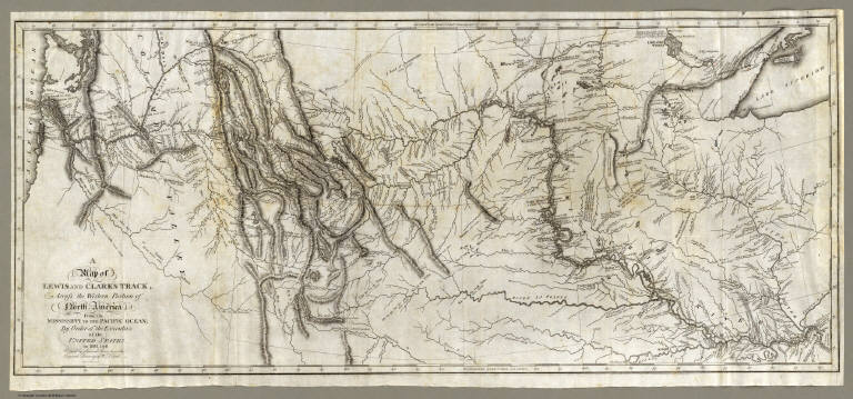
[Allen, Paul, Biddle, Nicholas, Clark, William, Lewis, Meriwether]
Full Title
(Title Page to) History Of The Expedition Under The Command Of Captains Lewis And Clark, To The Sources Of The Missouri, Thence Across The Rocky Mountains And Down The River Columbia To The Pacific Ocean. Performed During The Years 1804-5-6. By order of the Government Of The United States. Prepared For The Press By Paul Allen, Esquire. In Two Volumes. Vol. I. Philadelphia: Published By Bradford And Inskeep, New York. J. Maxwell, Printer. 1814 ... Vol. II.
List No
3493A
Note
1st edition. Notwithstanding the title, Nicholas Biddle completed the text after Lewis's suicide. The map and the written account of the expedition changed American mapping of the northwest by giving the first accurate depiction of the relationship of the sources of the Missouri, the sources of the Columbia, and the Rocky Mountains. The map was copied by Samuel Lewis from William Clark's original drawing, and was engraved by Samuel Harrison. The title of the map is "A Map of Lewis and Clark's Track, Across the Western Portion of North America From the Mississippi to the Pacific Ocean ..." Maps are without color. In 2 volumes newly bound in full leather with the title "Lewis & Clark's Expedition ..." stamped in gilt on the spine.
Author
Letts, Son & Co.
Full Title
Statistical & general map of India. No. 2. Letts's popular atlas. Letts, Son & Co. Limited, London. (1883)
List No
5371.083
Note
Colored map. Relief shown by hachures and spot heights. Shows cities, political divisions, European possessions, telegraph lines, roads, railroads, coffee plantations, forests, lights and lighthouses, etc. Covers Mysore and Carnatic.
Author
American Publishing Company
Full Title
Rambles Through Our Country. An Instructive Geographical Game For The Young. Copyright Secured 1881. American Publishing Company. Hartford, Conn. 1886.
List No
3886.000
Note
This is meant to accompany a board game with a map of the United States (see our #5086). However, it functions as a geography of the U.S. by itself. In full color.
Author
[Cook, James, 1728-1779, Hawkesworth, John, 1715?-1773]
Full Title
(Native implements, Ohiteroa and Otaheite). No. 12. (London: printed for W. Strahan; and T. Cadell in the Strand, MDCCLXXIII).
List No
3403.026
Note
Engraved illustration. The middle figure represents a fly-flap of the Island Oheteroa; the two side figures are handles of the instrument made in Otaheite.
Author
[Blaskowitz, Charles, Faden, William, 1750?-1836]
Full Title
A Topographical Chart of the Bay of Narraganset in the Province of New England, with all the Isles contained therein, among which Rhode Island and Connonicut have been particularly Surveyed, Shewing the true position & bearings of the Banks, Shoals, Rocks &c. as likewise the Soundings: To which have been added the several Works & Batteries raised by the Americans. Taken by Order of the Principal Farmers on Rhode Island, By Charles Blaskowitz. Engraved & Printed for Wm. Faden, Charing Cross, as the Act directs, July 22d 1777. To the Right Honourable Hugh Earl Percy, Baron Percy, Lucy, Poinings, Fitz-Paine, Bryan & Latimer, Lieutenant General of His Majesty's Forces in Great Britain and America. This Plan is ... most humbly Inscribed, by ... Wm. Faden. (in manuscript) Hinck S.
List No
3951.001
Note
The most important map of the area around Providence and Newport issued during the Revolution. With hand painted color. A separately issued copy dissected into 16 sections and mounted on linen. Folds into a marbled slip case 24x17 with a paper label with "Rhode Island" printed in manuscript.
Author
Reichard, C. G.
Full Title
Atlas des ganzen Erdkreises in der Central-Projection entworfen von C.G. Reichard. Erste Tafel. 1803.
List No
5762.001
Note
Engraved hand colored map. Relief shown by hachures. Shows settlements, rivers, Asia and Africa in full color, Europe in outline color, etc. Prime meridian: Ferro.
Author
Northern Pacific Railway Company
Full Title
Yellowstone National Park. Northern Pacific Railway. Poole Bros., Chicago. Copyrighted, 1898, by Poole Bros., Chicago.
List No
4118.001
Note
Relief shown by shading and spot heights. Shows completed and proposed railroads. David Rumsey Collection copy: A traveler has marked his route around the park in red ink.
Author
Paul, Rene
Full Title
Map Of The City Of St. Louis Compiled from information in the possession of Rene Paul Esqr. 1844. Published By Twichel & Cook N.W. Cor. Main & Pine Sts. St. Louis Mo. Engraved at the Office of J.T. Hammond, By T. Twichel. N.W. Cor. Main & Pine Streets. St. Louis Mo.
List No
4197.001
Note
Second edition. In covers with printed paper label "Map of the City of St. Louis, 1844." Engraved map, with three vignettes, two of buildings and one of a steamboat on the Mississippi River. Table of population statistics and a key to the important buildings located on the map. Color coded by ward. A beautiful map, exquisitely colored, and scarce. Rene Paul, the city surveyor, first issued this map in 1842. In 1835 Paul did a larger map of St. Louis separately and for Eugene Charles Dupre's Atlas of the City and County of St. Louis (illustrated in Ristow p.296, Karrow 9-1553-4). This earlier map was lithographed by Lehman & Duval. Folded into dark brown cloth covers 13x8 with "Map Of The City Of St. Louis, 1844" printed in black on yellow paste down label.
Author
Betts, John
Full Title
By The Queens Royal Letters Patent. Betts's New Portable Terrestrial Globe. Compiled from The Latest and Best Authorities. London, John Betts, 115 Strand.
List No
4362.000
Note
The first edition of Betts' collapsible 15-inch "umbrella" type globe. The date is estimated from the U.S. geography. Later editions continued to the end of the century. In the original wooden box with advertisements for Betts' geographical products. It is interesting that the color is printed onto the gores - thus being a fairly early example of color lithography.
Author
Jefferys, Thomas
Full Title
Thomas Jefferys Engraver Geographer to His Royal Highness the Prince of Wales, at y Corner of St. Martins Lane near Charing Cross Sells great Variety of Prints English and Foreign by the most Celebrated Masters And all Sorts of Maps and Globes. Ant: Walker. Inv: del: et Sculpt. (trade card advertisement).
List No
4239A
Note
A rare advertisement for Jefferys' publications and products. The date is estimated. It is interesting that this does not emphasize the maps as much as the prints, reflecting the fact that he had a large business at this time as a general engraver. Apparently, he published this trade card to "mark his arrival in the Strand" (Harley, Imago Mundi XX), and to announce the opening of his new premises there. Card uncolored.
Author
Cook, James
Full Title
A Map of the Province of South Carolina with all the Rivers, Creeks, Bays, Inletts, Islands, Inland Navigation, Soundings, Time of High Water on the Sea Coast, Roads, Marshes, Ferrys, Bridges, Swamps, Parishes Churches, Towns, Townships; Country Parish District and Provincial Lines. Humbly inscribed to the Hon.ble Lawlins Lownds Esqr. Speaker & the rest of the Members of the Hon.ble the Commons House of Assembly of the Province by their most Obedt. & faithfull Servt Jams Cook. Thos. Bowen, sculpt. 1773. (with 6 inset maps).
List No
5174.000
Note
The maker of this map, James Cook, surveyor of South Carolina and former marine surveyor, is not to be confused with the Pacific explorer, Captain James Cook. In 1770, James Cook was commissioned by the South Carolina provincial government to make a new survey of the entire province and publish a map, which he completed in 1773. Cummings refers to the map as "the most detailed and accurate printed map of South Carolina, especially for the interior, yet to appear" and further states that "very few copies of this fine map are extant." It provided much of the detail for the later maps by Henry Mouzon and John Stuart. Sellers and Van Ee call it "one of the most important maps in the cartography of the state until the early nineteenth century." It is excessively rare, with only five copies identified in United States institutions, and one in the British Museum. There are two states of this first and only issue, distinguished by the presence in the second state of an additional imprint "Publish'd according to Act of Parliament July 7th. 1773 and Sold by H. Parker in Cornhill" under the neat line. This copy is the first state, with two of the other six copies being first state as well. There are six inset maps: Beaufort, Camden, Georgetown, Port Royal, Charles Town, and Harbour of Charles Town. The main map is very detailed, showing land owners in profusion. Along the coast are many navigation notes, indicative of Cook's maritime background. This appears to have been Cook's only major map production; his other work is limited to three harbor charts published in 1766 (illustrated by Black): A Draught of Port Royal Harbour (similar to the Port Royal inset map on the South Carolina 1773), A Draught of the Harbour of Halifax, and A Draught of West Florida.
Author
Houston And Texas Central Railway
Full Title
Texas and Mexico showing Houston and Texas Central system of railways. Rand, McNally & Co, Engr's, Chicago. (inset) Map of United States and Mexico reduced scale; showing the Houston and Texas Central Railway and connections. (1885)
List No
5237.001
Note
Col. map. Includes statistical table: Counties traversed by the Houston & Texas Central Railway
Author
Houston And Texas Central Railway
Full Title
(Covers to:) Houston and Texas Central Railway through Texas. Northern to southern boundary and with branches and Texas Central Railway through central and western Texas ... 461-July-85. Rand, McNally & Co., Printers, Chicago.
List No
5237A
Note
Self wrappers with text, view and timetable.
Author
Alaska Steamship Company
Full Title
Territory of Alaska. The Alaska Line. The All-American Route, Alaska Steamship Company, Serving All of Alaska. Copyright 1936, Frank McCaffrey, Seattle. Printed in U.S.A. (with two inset maps)
List No
5300.000
Note
Map is in full printed color. Inset maps: 1) Untitled map of the area around Anchorage and the Gulf of Alaska. 2) Untitled map of North America showing the routes from the "lower 48" to Alaska. A table of distances is included showing the mileage from Seattle to places in Alaska. The border is bright and original with totem poles. Mt. McKinley National Park is highlighted in green.
Author
[Hall, E.S., Lloyd, H.H., Waters & Son]
Full Title
Military Portraits. Glossary Of War Terms, Maps, Arms, Etc. (Map of) Maryland, Virginia, Chesapeake Bay, Etc., Etc. Published by H.H. Lloyd & Co., 25 Howard Street, New York. Agents wanted to sell this and many other Charts for the times. Entered ... 1861, by H.H. Lloyd & Co.
List No
5395.000
Note
A very decorative Civil War chart showing military uniforms and dress, 10 portraits of prominent Union Officers, and a map delineating battles around Washington.
Author
May, B. y Ca.
Full Title
Plano Pintoresco De La Habana con los numeros de las casas B. May y Ca. 1853. (with) Inset map Puerto y Cereanias De La Habana. (with) 14 views of Havana & prominent buildings.
List No
5444.000
Note
Colored lithographic map with views of the city of Havana including the "Fuente De La India En El Paseo De Isabel 2a." and "Vista Gral De La Habana." Text on map discusses the number of houses in the city.
Author
Holdredge, Sterling M.
Full Title
(Illustrated Title Page to) State, Territorial and Ocean Guide Book of the Pacific: Containing The Time and Distance Tables ... on or Connecting with the Pacific Coast and the Interior ... To Which Are Added Nine Large and Reliable Maps Showing Principal Towns, Routes of Communication, etc. San Francisco: Published Semi-Annually by Sterling M. Holdredge. ... 1866.
List No
2544A
Note
Cowen p289. 2nd edition, 1st was 1865. Only two editions are known, 1865 and 1866 (Wheat). Wheat praised these maps and illustrated all nine. With a beautiful chromo litho title page illustrated with a globe showing the western hemisphere. Transportation scenes surround globe, including ships, a riverboat, train, and stagecoach. The nine maps are all double page and full of interesting information. They were lithographed by Grafton T. Brown, the first black lithographer in San Francisco. Rare. Book bound with cloth covers and "Guide Book of the Pacific" on the spine.
Author
[Bonne, Rigobert, 1727-1794, Lattre, Jean]
Full Title
(Title Page to) Atlas moderne ou collection de cartes sur toutes les parties du globe terrestre ar plusieurs auteurs. Avec approbation & privilege du Roy. A Paris, Chez Lattre Graveur Ordinaire du Roy, de Mgr. Le Duc d'Orleans et de la Ville Rue St. Jacques No. 20. et Delalain Libraire, rue de la Comedie Francoise, (1791) (title page only) Monnet del. 1762. Prevost Sculp.
List No
2612B
Note
Engraved decorative title page. Maps by Bonne, Janvier, & Rizzi Zannoni. Late edition which includes important maps of the United States, British America, and Mexico which do not appear in the earlier editions. Also has an excellent catalogue of Lattre's publications. The first edition of this atlas had 36 maps (see Baskes copy). Maps are with outline hand col. and bound in full brown leather covers embossed with "Atlas Moderne" on the spine.
Author
Bonne, Rigobert, 1727-1794
Full Title
(Composite of) Carte de la Guinee, contenant les Isles du Cap Verd, le Senegal, la Cote de Guinee proprement dite, les Royaumes de Loango, Congo, Angola et Benguela, avec les pays voisins autant qu'ils sont connus. Projettee et assujettie aux observations. Par M. Bonne, Hydrog(raph)e du Roi. A Paris, chez Lattre, rue St. Jacques, a la Ville de Bordeaux, avec priv. du R., 1781.
List No
2612.067
Note
Engraved map on 2 sheets. Covers part of West and Central Africa from Senegal to Angola. Boundaries outlined in hand col. Relief shown pictorially. Ornamental cartouche. Prime meridian: Ferro. Sheets also numbered XXXI and XXXII."
Author
Robert de Vaugondy, Gilles, 1688-1766
Full Title
(Title Page to) Atlas Universel, Par M. Robert Geographe ordinaire du Roy, et Par M. Robert De Vaugondy son fils Geographe ord. du Roy, et de S. M. Polonoise, Duc de Lorraine et de Bar, et Associe de L'Academie Royale des Sciences et belles Lettres de Nancy, Avec Privilege Du Roy, 1757. A Paris, Chez Les Auteurs ,Quay de l'Horloge du Palais, Boudet Libraire Imprimeur du Roi, rue St. Jacques. Grave par Ch. Baquoy. J. Oger Scripsit.
List No
3353B
Note
1st edition, with five postal maps added, as issued. With the list of subscribers and the extra postal maps of England, France, Germany, Italy and Spain. The French postal map is dated 1758. All five were added after the printed list of maps was printed, but are mentioned by Vaugondy in the preface, so they may have been an afterthought. An owner has added their titles to the printed list of maps, in ms. Engraved title page, Advertisement, and Geographical essay giving the sources of the maps. This atlas was reissued until 1799 (Phillips), with later issues having a map of the United States. In original half leather patterned paper covered boards with spine reading "Nouvel Atlas De Mrs. Robert." One of the first atlases based on scientific surveys, in the tradition of D'Anville and De L'Isle. Outline color.
Author
Carver, Jonathan
Full Title
A New Map of North America, From the Latest Discoveries. 1778. Engrav'd for Carvers Travels.
List No
0131.001
Note
Map in color with the majority in outline color and the Midwest in full color. Stretches to Baffin Bay in the north.
Author
[Cruz Cano y Olmedilla, Juan de la, d. 1790, Faden, William, 1750?-1836]
Full Title
Mapa Geografico de America Meridional, Dispuesto y Gravado por D. Juan de la Cruz Cano y Olmedilla, Geogfo. Pensdo. de S.M. Individuo de la Rl. Acadenia de Sn Fernando, y da la Sociedad Bascongada de los Amigos del Pais; teniendo presentes Varios Mapas y noticias originales con arreglo a Observaciones astronomicas, Ano de 1775 ... Londres, Publicaddo por Guillermo Faden, Geografo del Rey, y del Principo de Gales, Enero 1. de 1799.
List No
0220.000
Note
Reissue by Faden of 1775 original, 3rd edition. See Imago Mundi XX for a full discussion of this map. Faden's issue is an exact copy of the 3rd edition, omitting the borders and changing the title area. Smith, in his article in I.M., calls Cano's map the South American equivalent of Mitchell's map of the British Colonies of 1755. Outline hand color. Relief shown pictorially. Extensive notes. Map is in two sheets dissected into 18 sections each. Folds into a new cloth folding case 33x25 with "America Meridional Cruz Cano 1799" stamped in gilt on the spine.
Author
[Transcontinental Air Transport, Inc., Funk & Wagnalls Company.]
Full Title
Illustrated Map of the Route of Transcontinental Air Transport, Inc. TAT. Copyright, Rand McNally & Company. 7134 - New York 6-29.
List No
3704.002
Note
Map in full color with drawings of interesting features in the United States. Below the main map is an elevation profile with lines leading up to the point along the route noted below. The profile delineates the states, mileage and the height of the features on the profile. The route of the airplane is shown in blue and includes an airplane making the trip. Surround the map and profile are drawings of natural features and cities throughout the United States.
Author
[Bligh, William, 1754-1817, Cook, James, 1728-1779, Webber, John, 1751-1793]
Full Title
Views on the west coast of America. (London, G. Nicol and T. Cadell, 1785)
List No
3405.011
Note
Nine engraved coastal views. Contents: View when Table Hill bore E b. N 1/2 N. W. Bligh del. -- View when Mount Edgcumbe bore N.W. b. N. & leas. distt. W, Bligh del. -- View of the entrance of Nootka Sound ... -- View of Mount Edgecumbe ... -- View when Mount St. Elias bore N.W. b W. 20 leas. W. Bligh del. -- View of Kaye's Island ... W. Bligh del. -- View of Kayes Islands ... J. Webber del. -- View of the land in Prince William's Sound ... "86."
Author
Jefferys, Thomas
Full Title
(Engraved title page to) The West-India atlas: or, a compendious description of the West-Indies: illustrated with forty one correct charts and maps, taken From actual surveys. Together with an historical account of the several countries and islands which compose that part of the world. By the late Thomas Jefferys, Geographer to the King. London: Printed for Robert Sayer and John Bennett, Map, Chart, Print-Sellers, and Globe Makers, Fleet-Street, M,DCC,LXXXIII.
List No
4723B
Note
This is a superb atlas of the West Indies and a companion atlas to Jeffery's American Atlas also first issued in 1775. The latest date on the charts in this copy is 1788 (The Cape Verd Islands). There is a beautifully illustrated title page that precedes the main title page, which reads "The West Indian Atlas..." Jefferys died in 1771; Sayer and Bennet acquired his materials in preparation for this atlas, and published the atlas posthumously under his name (as they did with the American Atlas) in 1775. The heart of this atlas and the most detailed part is the sixteen sheet large chart and index sheet of the whole of the West Indies. The rest of the atlas consists of charts of the Atlantic Islands and the British Channel, as well as individual maps and charts of seventeen islands in the West Indies. Twenty seven pages of text gives the sources for the maps and charts, and a historical account of the West Indies. Three of the large chart maps also appeared in the American Atlas. Comparing the two Florida sheets in this atlas to the same sheets in the 1775 American Atlas, numerous changes to the coast lines and other features appear. That would indicate that Sayer updated the charts as the atlas was reissued - Phillips shows issues of 1775, 1781, 1787, 1794, 1796, 1807, and 1818. With the 1794 and later editions, 20 maps are added of various additional islands. Sayer and Bennet also published in 1775 a smaller version of this atlas called "The West India Islands: From Actual Survey and Observations..." that consisted of the same text, a general chart of the Islands, and the same sixteen or seventeen (depending on the edition) charts of the islands that appear in the larger version (P3942). Finally, Jefferys himself published in 1762 "A Description of the Spanish Islands and Settlements on the Coast of the West Indies" which was issued in quarto, with a general chart and 32 maps and plans of harbors and towns (P3941).
Author
[Touring club italiano, Funk & Wagnalls Company.]
Full Title
Australia di Sud-est, South-east Australia. Propr. Artistico-letteraria del T.C.I. Ufficio cartografico del T.C.I. (1929)
List No
1012.091
Note
Color map. Relief shown by hachures and spot heights; depths by isolines.
Author
Smith, Charles, fl. 1800-1822
Full Title
Comparative View Of The Heights Of The Principal Mountains &c. In The World. Western Hemisphere. Eastern Hemisphere. London, Published by C. Smith, Mapseller No. 172 Strand, Augt. 1st 1816. Gardner Sculpt.
List No
0909.000
Note
Shows the comparative heights of mountains in the Eastern and Western Hemispheres, as well as the comparative heights of important places. A list of Authorities is given to the left of the title, and an Explanation shows how the system of numbering mountains and places works. A former owner has added "6225....White Mountains, N.H." to the table. This chart may be one of the earliest of its genre; it is not listed in Wolter's "Heights of Mountains..." (he lists the Thomson 1817 similar chart as the first of this type). The British Museum lists this Smith as the first chart of this kind. Interestingly, Smith's chart does not show the Himalayan Mountains; Thomson adds the Himalayan Mountains to his chart with a note about the recent publication of data on their heights. With black top and bottom sticks, and green silk edging. Full hand painted color.
Author
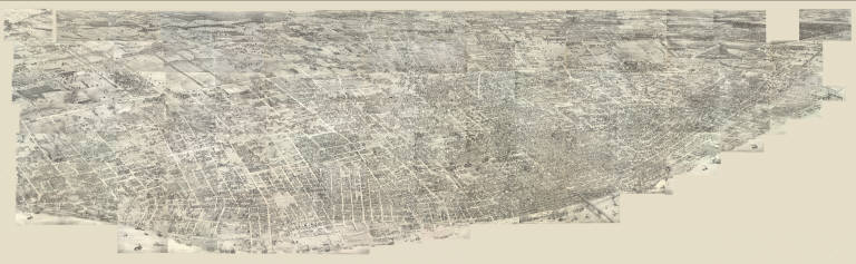
[Compton, Richard J., Dry, Camille N.]
Full Title
(Pictorial St. Louis) Composite (By C.N. Dry, 1876)
List No
4209.058
Note
Composite of 110 lithographed views.
Author
[Cook, James, 1728-1779, Webber, John, 1751-1793]
Full Title
A view of Huaheine. J. Webber del. W. Byrne sculp. (London, G. Nicol and T. Cadell, 1785)
List No
3405.048
Note
Engraved illustration. Shows islanders on shore and in boats, British ships, harbor, vegetation, hills in background.
Author
[Geographical and Geological Survey of the Rocky Mountain Region (U.S.), Jenney, Walter Proctor, 1849-1921, Newton, Henry, 1845-1877]
Full Title
Bird's eye view of the Black Hills to illustrate the geological structure. Dept. of the Interior, U.S.G. and G. Survey, J.W. Powell, in charge. Geology of the Black Hills by Henry Newton, E.M. (Julius Bien, Lith. New York, 1879)
List No
2083.001
Author
Arrowsmith, Aaron
Full Title
A Map Exhibiting all the New Discoveries in the Interior Parts of North America Inscribed by Permission To the Honorable Governor And Company Of Adventurers Of England Trading Into Hudson Bay In testimony of their liberal Communications To their most Obedient and very Humble Servant, A. Arrowsmith, Hydrographer to H.R.H. the Prince of Wales. No. 10 Soho Square, January 1st 1795. Additions to 1811. Additions to 1814. London: Published Jan. 1, 1795 by A. Arrowsmith No. 10 Soho Square. Additions to 1802 ...
List No
0032.001
Note
This issue incorporates the Lewis and Clark discoveries (and other discoveries) and remaps the entire continent west of the Mississippi. The changes between this and the last edition (1811) are monumental. This copy is from the collection of Sir Charles Broke (or Brooke, subsequently Vere). Broke was in Lower Canada with his regiment, the 5th (Northumberland) Regiment of Foot, which was at the battle of Plattsburg in 1814. Later, he was with the Army of Occupation in France, receiving the Waterloo medal despite arriving from Canada too late for the battle (from Manasek). Without color. Dissected into 40 sections and mounted on linen. Folds into a new gray cloth covered box case 29x22x7 with "North America A. Arrowsmith 1814" stamped on the spine in gold.
Author
Holbrook, Charles W.
Full Title
Chas. W. Holbrook's Twelve inch Globe Containing the Latest Political Divisions, And Ocean Currents. Revised to Date. 1890.
List No
0326.000
Note
Interesting "modern" iron stand. Globe shows isothermal lines and currents. Globe measures 12-inches and stands 22-inches from top to base.
Author
[Bruff, J. Goldsborough, Disturnell, John]
Full Title
A Correct Map Of The Seat Of War In Mexico. Being a Copy of Genl. Arista's Map, taken at Resaca de la Palma, with additions and Corrections ... New York: Published By J. Disturnell. 102, Broadway, 1847. Designed by J.G. Bruff Washington D.C. Entered ... 1847, by J.G. Bruff ... New York. Lith. of E. Jones & G.W. Newman, 128, Fulton St. On Stone by J. Probst. (with 4 inset maps).
List No
0097.001
Note
Scarce map with Drawings by Bruff. According to Tooley, Bruff did: State of Florida, 1846; this map; Tehuantepec maps, 1851; Seat of War in Virginia, 1861. In Phillips p410, this map and another smaller map also published by Disturnell are listed. From the Introduction to his travel diary, it is clear that Bruff drew for the Topographical Engineers and other government departments for over 50 years. Many of his products may not have his name on them - he is quoted in the introduction (page xxx) saying that he drew duplicates of the Fremont maps and plates for both houses of Congress. The four inset maps are titled: Plan of Monterey, Map Showing the Battle Grounds of the 8th and 9th May 1846, Tampico and its Environs, and Chart of the Bay of Vera Cruz. Map is folded into brown cloth covers 15x10 with "Map Of The Seat Of War In Mexico." stamped in gilt.
Author
Hutchins, Thomas
Full Title
A New Map of the Western Parts of Virginia, Pennsylvania, Maryland and North Carolina; Comprehending the River Ohio, and all the Rivers, which fall into it; Part of the River Mississippi, the Whole of the Illinois River, Lake Erie; Part of the Lakes Huron, Michigan &c. And all the Country bordering on these Lakes and Rivers. By Thos. Hutchins, Captain in the 60 Regiment of Foot. London, Published according to Act of Parliament Novembr. ye 1st, 1778 by T. Hutchins ... Engrav'd by T. Cheevers.
List No
5044.000
Note
This map was published separately and at the same time as Hutchins' "Topographical Description..." and should accompany the book. Streeter calls it "by far the best map of the west printed to that time." It was the first large scale map of the area west of the Allegheny Mountains based on personal observations, although Hutchins gives credit to Lewis Evans' "Map of the Middle Colonies" as the best prior source of information about the area. The map contains extensive printed notes which describe important aspects of the country depicted. This map ranks with the most important American maps issued in the 18th century and is now rare. Hutchins later became the first Geographer of the United States. With outline color. Map is dissected into 32 sections and mounted on linen. Folds into new green cloth folding boards and quarter leather green cloth slip case 24x16 with "Hutchin's New Map Of Western Parts Of Virginia, Etc. 1778" on the spine in gold.
Author
[Mitchell, John, Raynal, G.T., Zatta, Antonio]
Full Title
(Title Page to) Storia Dell' America Settentrionale Del Signor Abate Raynal Continuata fino al present, con Carte Geografiche rappresentanti il Teatro della Guerra Civile tra la Gran Bretagna, e le Colonie Unite. A SS. EE. Li Signori Rifoormatori Dello Studio Di Padova. In Venezia, Dalle Stampe Di Antonio Zatta Con Licenza De Superiori, E Privilegio. M. DCC. LXXVIII.
List No
5007A
Note
In addition to a two volume Italian translation of Raynal's History of North America, this book contains the first edition of Zatta's twelve sheet version of Mitchell's Map of North America, plus three other maps: Il Canada, Le Isole di Terra Nuova e Capo Breton, and La Baja D' Hudson. All of these maps appeared also in Zatta's Atlante Novissimo published from 1779-1785. A second edition of the Zatta/Mitchell maps was published in 1791 (see P651). Zatta's version of Mitchell is not an exact or complete copy: the Zatta maps do not cover the far western portions of Mitchell's map, many geographical changes are introduced, and Bermuda is depicted as well as Jamaica., neither of which are shown by Mitchell. A separate map covers Newfoundland and Cape Breton, on the same scale. Maps are hand painted with outline color. Covers are quarter leather light brown marbled paper covered boards with "Raynal. Storia Dell' America Settentrionale. 1778" stamped in gilt on the new leather spine.
Author
Wyld, James, 1812-1887
Full Title
Map of North America from 20 to 80 Degrees North Latitude Exhibiting The recent Discoveries, Geographical and Nautical; Drawn chiefly from the Authorities of M. De Humboldt, Lieutt. Pike, Messrs. Lewis and Clarke, Sir Alexr. MacKenzie, Mr. Hearne, Coll. Bouchette, Captns. Vancouver, Ross, Parry & Franklin, also describing the Boundary Lines between the Territories of Great Britain & Spain with the United States. London, Published by Jas. Wyld, (successor to W. Faden) No. 5, Charing Cross. Geographer to His Majesty; and to H.R.H. the Duke Of York. June 1st 1823.
List No
4087.001
Note
The first edition, listed in Phillips but not by Stevens and Tree or Wheat (both list 1824/25 as the first edition). A large impressive map showing with great accuracy the recent discoveries in the north west passage, but wildly off in the American southwest - Wheat: "a large and beautiful map, excellent in all respects save for its southwestern geography." In the southwest, Wyld adds many mountain ranges that were purely speculative - probably just to fill in blank spaces in the map (unlike Arrowsmith). In northwestern Texas is a curious note on the topography of the area attributed to "Mellish" which is copied from a pre-1822 edition of his large map of the United States. Comparing this edition to the derived map of 1846, "Mexico, the British Possessions...," one sees many changes in the northern areas and few in the southwest. Stevens and Tree list editions of 1824, 1827/8, 1838, and 1851/56. The 1824/25 edition adds a fold out flap of Mexico and Central America (WH copy). With outline color. Map is dissected into 24 sections and mounted on linen. Map folds into a brown marbled paper covered slip case with black leather spine with "Map Of North America" stamped in gilt.
Author
[Spangenberg, Charles, Matz, Otto H.]
Full Title
Map Of The Siege Of Vicksburg, Miss. By the U.S. Forces Under The Command Of Maj. Genl. U.S. Grant, U.S. Vls. ... Surveyed and constructed under the direction of Capt. C.B. Comstock ... by Major Otto H. Matz ... Chs. Spangenberg ... Drawn by Chs. Spangenberg ... Engr. on stone by J. Schedler No. 120 Pearl St. N.Y. Head Qrs. Of The Dept. Of The Tenn. Vicksburg Miss. Aug. 20th 1863. C.B. Comstock ...
List No
3858.000
Note
Signed in facsimile by C.B. Comstock and dated Aug. 20, 1863, Vicksburg, Miss. Beautiful, highly detailed black and white map showing the topography around Vicksburg, with five profiles, six cross sections of batteries and one cross section of a "rebel rifle pit." Illustrated in Stephenson, this is one of the most striking of the Union War maps. Plate 36:2 in "Atlas to Accompany..."
Author
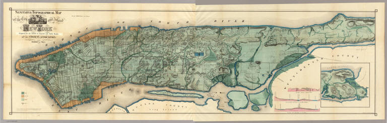
Viele, Egbert L.
Full Title
Sanitary & Topographical Map of the City and Island of New York Prepared for the Council of Hygiene and Public Health of the Citizens Association. Under the direction of Egbert L. Viele, Topographical Engineer. Entered ... 1865 by Egbert L. Viele ... New York. Ferd. Mayer & Co. Lithographers, 96 Fulton St. N.Y. (with 1 inset map and 3 profiles).
List No
3723.000
Note
For some reason Haskell and Stokes date this map 1864 although it was copyrighted by Viele in 1865. Removed from the Report of the Council of Hygiene (see our copy). The map shows all the original water courses of Manhattan Island, with the street grid superimposed on top. Also, three different kinds of land are shown: Marsh, Made Land, and Meadow. Sewer lines are indicated. A very beautiful full color map occasioned by a not so beautiful subject. In 1874 Viele reissued the map in larger format as the Topographical Atlas of the City of New York (see our copy). This map was also published as a separate pocket map, in covers.
Author
[Allen, Paul, Biddle, Nicholas, Clark, William, Lewis, Meriwether]
Full Title
A Map of Lewis and Clark's Track, Across the Western Portion of North America From the Mississippi to the Pacific Ocean; By Order of the Executive of the United States, in 1804, 5 & 6. Copied by Samuel Lewis from the Original Drawing of Wm. Clark. Smal. Harrison fct.
List No
3493.001
Note
Uncolored map showing topography and rivers in the region as well as towns, Indian villages, and population figures. Bound into the front of volume one.
Author
United States Coast Survey
Full Title
U.S. Coast Survey A.D. Bache, Superintendent, City Of San Francisco And Its Vicinity California. From a Trigonometrical Survey by R.D. Cutts, Assistant. Topography by A.F. Rodgers Sub-assistant. Hydrography by the Party under the command of Lieut. James Alden U.S.N. Asst. 1853. U.S. Coast Survey Office. Price 50 Cents. Verified I.I. Stevens ... No. 627. Outlines and Topography engraved by Max. F.O. Strobel; Lettering by E.F. Woodward.
List No
3463.000
Note
Vogdes shows this as the first edition. Vogdes says that the survey was completed in April, 1852, and that the interior topography was taken from Eddy's official map of the city. We have a reproduction of an earlier state of the chart which has no soundings and is dated 1852; it says the plan of the city was taken from the map by Cooke and Le Count; there are differences in the piers and the buildings along the piers. We can find no reference for this earlier state. In the Annual Report of the Survey for 1853, another issue of the chart was published (litho) with the addition of more notes regarding tides in the upper left - this same chart was also issued (engraved on thin paper) in the collection of charts published by the survey in 1854. Map is without color.
Author
Goodwin, F.A.
Full Title
Map Of California And The Adjacent Country. Compiled by F. Goodwin From the best Authors and actual Observation. Entered ... 1855 by F. Goodwin ... New York. Lith. of Geo. E. Leefe, 223 Fulton St. N.Y. (with 8 page description) A Brief Description of California, From The Time of Its First Occupation by the United States and Subsequent Growth ... Accompanied by a Map of California and adjacent Country.
List No
3438.001
Note
Wheat calls this "rare but otherwise unimportant," due to some misspellings and inaccuracies in the map. Streeter sale illustrates the map and the price realized was the same as the Eddy map of 1853. I find the Wheat inaccuracies minor, with most of them being misspellings. The overall map is impressive. It would be interesting to find the map or maps that were used as sources. Ouline color by state. Folded into dark brown cloth covers 16.5x11 with "Map Of California And Adjacent Country By F. Goodwin" stamped in gilt.
Author
Ordway, Eliza S.
Full Title
Map Of The United States. Eliza S. Ordway.
List No
2454.000
Note
Date is approximate, estimated by Howard Welsh. Probably a school project. With black top and bottom rollers. Without color.
Author
Fremont, J.C.
Full Title
Map Of An Exploring Expedition To The Rocky Mountains in the Year 1842, Oregon & North California In The Years 1843-44. By Brevet Capt. J. C. Fremont Of The Corps Of Topographical Engineers Under the orders of Col. J.J. Abert, Chief Of The Topographical Bureau. Lith. by E. Weber & Co. Baltimore, Md.
List No
1833.001
Note
House Issue; map in case. Lacks the astronomical observations that appear in the first issue by the Senate. The large map of the west is one of the most interesting and beautiful government maps of the 1840's. It filled in many of the gaps in cartographic knowledge of the west. Charles Preuss was the cartographer. Fremont and Preuss mapped only what they saw along their routes, leaving large areas blank. Map is without color. Book is bound with full leather with "Executive Documents 2d Sess. 28th Cong." on the spine in gold.
|