Author
[Geographisches Institut (Weimar, Germany), Weiland, Carl Ferdinand, 1782 -1847]
Full Title
Die Konigl. Preussischen Provinzen Westphalen und Rhein-Provinz nebst dem Kurfurstenthum Hessen, Grossherzogthum Hessen, Herzogthum Nassau, Furstenthum Waldeck und dem Gebiete der freien Stadt Frankfurt, entworfen und gezeichnet von C.F. Weiland. Gest. v. C. Jungmann. Weimar, im Verlage der geographischen Instituts, 1856.
List No
2077.018
Note
Engraved map. Outline hand col. Relief shown by hachures. Includes area and population table.
Author
Johnston, W. & A.K.
Full Title
Empire of Germany (southern portion). (with) Frankfurt. (with) Munich. Keith Johnston's General Atlas. Feb. 1912. Engraved, Printed, and Published by W. & A.K. Johnston, Limited, Edinburgh & London.
List No
2763.027
Note
Fold out map. States and counties outlined in color. Relief shown by hachures. Three scales.
Author
Meyer, Joseph, 1796-1856
Full Title
Frankfurt am Mayn, 1845. Aus der Geographischen Graviranstalt des Bibliographischen Instituts zu Hildburghausen, Amsterdam, Paris u. Philadelphia, (1860)
List No
4807.040
Note
Engraved map. Includes view of Frankfurt from Sachshausen. Legend in German, English and French. A revision of the 1837 map published by the Society for the Diffusion of Useful Knowledge, London. "Meyers Handatlas No. 62."
Author
Society for the Diffusion of Useful Knowledge (Great Britain)
Full Title
Frankfort. Frankfurt am Mayn. Published under the superintendence of the Society for the Diffusion of Useful Knowledge. Drawn by W.B. Clarke, Archt. Engraved by T.E. Nicholson. Printed by E. Brain. Published Baldwin & Cradock, 47 Paternoster Row, 1837. (London: Chapman & Hall, 1844)
List No
0890.177
Note
Engraved map. Hand col. Inset: View of Frankfort, from Sachsenhausen.
Author
Holmes, J.W.
Full Title
Map Of Saint Clair County, Illinois. Published by J.W. Holmes, Civil Engineer & Map Publisher, 1863. Field Surveys Conducted by R.S. Hodgen, C.E. & Surveyor. Manufactured by R. Pearsall Smith, 517, 519, 521 Minor St. Phila, Pa. Entered ... 1863 by Joseph W. Holmes ... Illinois. (with 15 inset maps).
List No
3751.001
Note
County map in case map form - fairly rare, in that most county maps were mounted on rollers. The map was published by Robert Pearsall Smith (the two copies listed in Phillips were published by Sage and by Holmes, in Buffalo) in Philadelphia. St. Clair county is opposite St. Louis, giving it special importance. Full color with 15 inset maps and 13 views, and one advertisement.
Author
[Union Atlas Co., Warner & Beers]
Full Title
Map of St. Clair County. (with) Lebanon. (with) Carlyle. (Union Atlas Co., Warner & Beers, Proprietors. Lakeside Building Cor: of Clark & Adams Sts. Chicago. 1876. Entered ... 1876 by Warner & Beers ... Washington D.C.)
List No
1159.117
Note
Col. lithographed map with 2 city insets. Shows townships and sections, landowners, acreages, railroads, schools, churches, farm houses, timbered areas, etc. Lebanon map shows block numbers.
Author
Campbell, R.A.
Full Title
Campbell's topographical & sectional map of Madison, St. Clair, and Monroe counties. (Drawn by R.A. Campbell and H.F. Walling). Entered ... 1869 by R.A. Campbell ... Pennsylvania. (1870)
List No
2483.082
Note
Hand colored map. Shows townships, public land townships and sections, settlements, railroads, etc.
Author
Tanner, Henry S.
Full Title
Map Of North & South Carolina By H.S. Tanner. Improved To 1825. American Atlas. Entered ... 20th day of August 1823, by H.S. Tanner ... Pennsylvania. Published by H.S. Tanner, Philadelphia. Engraved by H.S. Tanner & Assistants.
List No
2755.014
Note
In full color by county.
Author
Finley, Anthony
Full Title
Map Of Virginia And Maryland Contrusted from the Latest Authorities. 1825. (with) Plan Of Washington City & Georgetown. Drawn by D.H. Vance. Engraved by J.H. Young. Published by A. Finley Philada. 1824.
List No
0278.007
Note
In full color by county with inset map uncolored. Statistical tables details the population in 1820 of "White, Free Black & Slave Population" by county.
Author
Society for the Diffusion of Useful Knowledge (Great Britain)
Full Title
Birmingham. Engraved & printed by J. Henshall, no. 1, Cloudesley Terrace, Islington. London, published by the Society for the Diffusion of Useful Knowledge, May 15th, 1839. (London: Chapman & Hall, 1844)
List No
0890.164
Note
Engraved map. Hand col. Includes "Plan of Birmingham and its environs," and drawings of the facades of 6 buildings.
Author
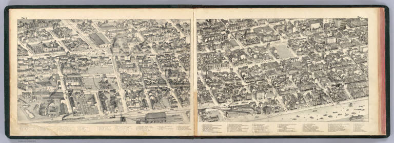
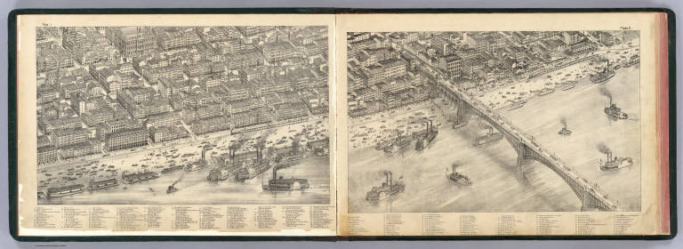
[Compton, Richard J., Dry, Camille N.]
Full Title
(Pictorial St. Louis) plate 3, plate 4. (By C.N. Dry, 1876)
List No
4209.004
Note
Two facing lithographed views. Covers area roughly Levee to 7th St. between Convent and Myrtle streets. Shows boats, wagons, trains, trolleys, pedestrians, etc. Includes keys to buildings.
Author
Mitchell, Samuel Augustus
Full Title
St. Louis. Entered ... 1870 by S. Augustus Mitchell, Jr. ... Pennsylvania.
List No
2483.033
Note
Hand colored. Shows wards, railroads, etc.
Author
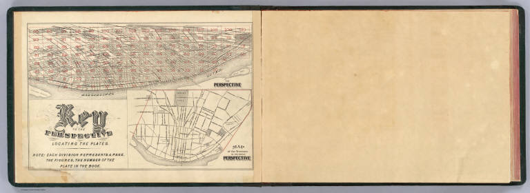
[Compton, Richard J., Dry, Camille N.]
Full Title
Key to the perspective locating the plates. Entered ... 1874 by Compton & Company ... Washington, D.C.
List No
4209.001
Note
Index map to sheets of the view. Inset map: Map of the territory in the above perspective. Color lithograph. Oriented with north toward right.
Author
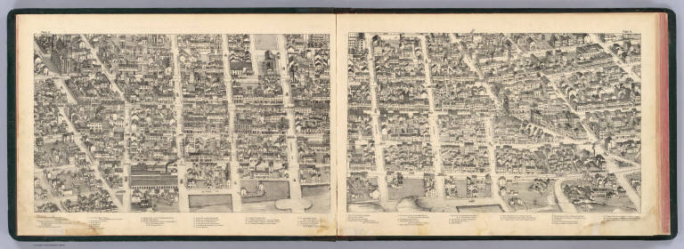
[Compton, Richard J., Dry, Camille N.]
Full Title
(Pictorial St. Louis) plate 5, plate 6. (By C.N. Dry, 1876)
List No
4209.005
Note
Two facing lithographed views. Shows wagons, trolleys, pedestrians, etc. Includes keys to buildings.
Author
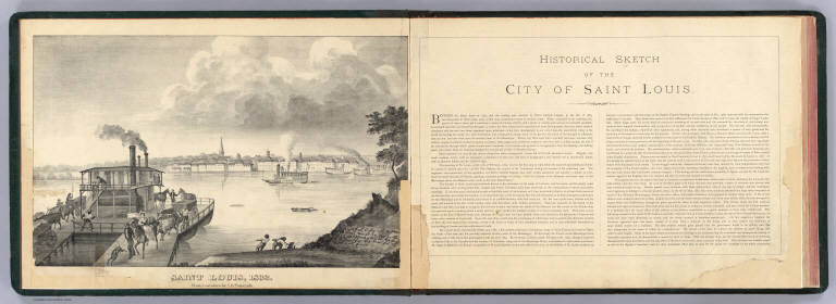
[Compton, Richard J., Dry, Camille N., Pomarade, L. D.]
Full Title
Saint Louis, 1832. From a painting by L.D. Pomarade. Entered ... 1876 by Compton & Company ... Washington, D.C.
List No
4209.002
Note
Lithographed view of the city from East Saint Louis showing riverfront building facades, boats, etc. Ferry with passengers and animals, dockworkers in foreground. With a certification by Pomarade, 1875.
Author
[Compton, Richard J., Dry, Camille N.]
Full Title
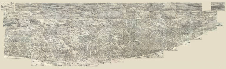
(Pictorial St. Louis) Composite (By C.N. Dry, 1876)
List No
4209.058
Note
Composite of 110 lithographed views.
Author
Asher & Adams
Full Title
Asher & Adams' Missouri. Entered according to Act of Congress in the year 1874 by Asher & Adams ... at Washington. (New York, 1874)
List No
0041.023
Note
Hand col. engraved map. Shows townships, distances along railroads, etc. Prime meridians: Greenwich and Washington.
Author
[Compton, Richard J., Dry, Camille N.]
Full Title
(Pictorial St. Louis) plate 1, plate 2. C.N. Dry. Entered ... 1874 by Compton & Company ... Washington, D.C.
List No
4209.003
Note
Two facing lithographed views. Covers area inland from the levee between Elm and Wash streets including the Eads Bridge. Shows boats, wagons, pedestrians, etc. Includes keys to buildings.
Author
Burr, David H., 1803-1875
Full Title
Map of Illinois & Missouri Exhibiting the Post Offices, Post Roads, Canals, Rail Roads, &c. By David H. Burr. (Late Topographer to the Post Office.) Geographer to the House of Representatives of the U.S. John Arrowsmith. Entered ... July 10th, 1839, by David H. Burr ... District of Columbia.
List No
0104.012
Note
In full color by county. Postal routes by coach, stage, sulkey, cross, rail roads and canals shown. In 8 sections mounted on linen. Label on back states "No. 12. Illinois, Missouri."
Author
Finley, Anthony
Full Title
Tennessee. Published by A. Finley Philada. Young & Delleker Sc.
List No
0285.025
Note
Full color by county.
Author
Colton, G.W.
Full Title
Illinois. (with) Vicinity Of Chicago. Published By J.H. Colton & Co. No. 172 William St. New York. Entered ... 1855 by J.H. Colton & Co. ... New York. No. 44.
List No
0149.049
Note
In full color by county.
Author
[Union Atlas Co., Warner & Beers]
Full Title
Belleville. (Union Atlas Co., Warner & Beers, Proprietors. Lakeside Building Cor: of Clark & Adams Sts. Chicago. 1876. Entered ... 1876 by Warner & Beers ... Washington D.C.)
List No
1159.116
Note
Hand col. lithographed map. Shows wards, block numbers, etc.
Author
[Union Atlas Co., Warner & Beers]
Full Title
Map of Jefferson County. (Union Atlas Co., Warner & Beers, Proprietors. Lakeside Building Cor: of Clark & Adams Sts. Chicago. 1876. Entered ... 1876 by Warner & Beers ... Washington D.C.)
List No
1159.119
Note
Col. lithographed map. Shows townships and sections, landowners, acreages, railroads, schools, churches, farm houses, timbered areas, etc.
Author
[Campbell, R.A., Union Atlas Co., Warner & Beers]
Full Title
Map of St. Louis City. Copyright 1872 by R.A. Campbell. (Union Atlas Co., Warner & Beers, Proprietors. Lakeside Building Cor: of Clark & Adams Sts. Chicago. 1876. Entered ... 1876 by Warner & Beers ... Washington D.C.)
List No
1159.143
Note
Col. lithographed map. Show wards, street car lines, etc.
Author
[Union Atlas Co., Warner & Beers]
Full Title
Official railroad map of Illinois. 1876. (Union Atlas Co., Warner & Beers, Proprietors. Lakeside Building Cor: of Clark & Adams Sts. Chicago. 1876. Entered ... 1876 by Warner & Beers ... Washington D.C.)
List No
1159.003
Note
Col. lithograph.
Author
Colton, G.W.
Full Title
The City of St. Louis, Missouri. The City of Chicago, Illinois. Published By G. W & C. B. Colton & Co. No. 172 William St. New York.
List No
0152.055
Note
The plans of Chicago & St. Louis are upon the same scale.
Full Title
Total population of each state and territory at each census. Ohio, Indiana, Michigan, Illinois, Wisconsin, Minnesota, Iowa, Missouri, N. Dakota, S. Dakota, Nebraska, Kansas, Montana, Wyoming, Colorado, New Mexico, Arizona, Utah, Nevada, Idaho, Washington, Oregon, California, Alaska, Hawaii. (Prepared under the supervision of Henry Gannett, Geographer of the Twelfth Census. United States Census Office, 1903. Julius Bien & Co., N.Y.)
List No
2152.019
Note
Lithographed graphs.
Author
Thompson, Thos. H.
Full Title
Map of Occidental (with) Plan of Geyserville. (both) Sonoma Co. California, 1877. Map Number One. (Salt Point, Mendocino, and Cloverdale Townships.)
List No
2205.006
Note
In full color.
Author
Mitchell, Samuel Augustus
Full Title
County map of Kentucky, and Tennessee. Entered ... 1870 by S. Augustus Mitchell, Jr. ... Pennsylvania.
List No
2483.021
Note
Hand colored. Relief shown by hachures. Shows settlements, railroads, etc. Prime meridians: Greenwich and Washington.
Author
Mitchell, Samuel Augustus
Full Title
County map of the state of Illinois. (with) Vicinity of Springfield. Entered ... 1870 by S. Augustus Mitchell, Jr. ... Pennsylvania.
List No
2483.030
Note
Hand colored map with inset. Shows settlements, railroads, etc. Prime meridians: Greenwich and Washington.
Author
Carey, Mathew
Full Title
Virginia. W. Barker sculp.
List No
4865.014
Note
Uncolored.
Author
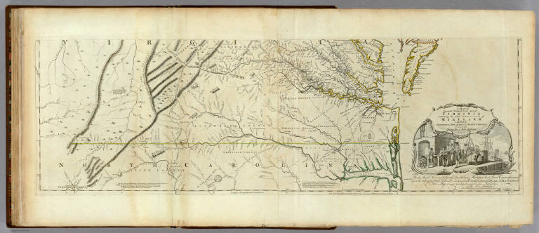
[Jefferys, Thomas, Fry, Joshua, 1700 (ca.)-1754, Jefferson, Peter, 1708-1754]
Full Title
A Map of the most Inhabited part of Virginia containing the whole province of Maryland with Part of Pensilvania, New Jersey and North Carolina. Drawn by Joshua Fry & Peter Jefferson in 1775. Printed for Robt. Sayer ... London. (Southern Section)
List No
0346.024
Note
Southern section in outline color and containing title cartouche. Note below cartouche states: "To the Right Honourable, George Dunk Earl of Halifax First Lord Commissioner; and to the Rest of the Right Honourable and Honourable Commissioners, for Trade and Plantations. This Map is most humbly Inscribed to their Lordships, By their Lordship's Most Obedient & most devoted humble Servt. Thos. Jefferys." Survey lines are noted and explained. In outline color by state.
Author
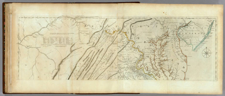
[Jefferys, Thomas, Fry, Joshua, 1700 (ca.)-1754, Jefferson, Peter, 1708-1754]
Full Title
A Map of the most Inhabited part of Virginia containing the whole province of Maryland with Part of Pensilvania, New Jersey and North Carolina. Drawn by Joshua Fry & Peter Jefferson in 1775. Printed for Robt. Sayer ... London. (Northern Section)
List No
0346.023
Note
Map in two sections this being the northern one. Distances and directions shown on chart derived by J. Dalrymple in 1755. Map in outline color by state. Title cartouche on lower half.
Author
[Fry, Joshua, 1700 (ca.)-1754, Jefferson, Peter, 1708-1754, Robert de Vaugondy, Didier, 1723-1786, Robert de Vaugondy, Gilles, 1688-1766]
Full Title
Carte de la Virginie et du Maryland. Dressee sur la grande carte Angloise de Mrs. Josue Fry et Pierre Jefferson, par le Sr. Robert de Vaugondy Geographe ordinaire du Roi. Avec Privilege 1755. Grave E. Haussard.
List No
3353.101
Note
Engraved map. Hand col. borders. Relief shown pictorially. Ornamental cartouche. Shows missions, forts, Native American tribes and villages, etc. First state of the Vaugondy version of the Fry and Jefferson map.
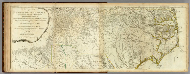
Author
[Jefferys, Thomas, Mouzon, Henry]
Full Title
An Accurate Map Of North And South Carolina With Their Indian Frontiers, Shewing in a distinct manner all the Mountains, Rivers, Swamps, Marshes, Bays, Creeks, Harbours, Sandbanks and Soundings on the Coasts; with The Roads and Indian Paths; as well as The Boundary or Provincial Lines, The Several Townships and other divisions of the Land In Both The Provinces; the whole From Actual Surveys By Henry Mouzon And Others. London. Printed for Robt. Sayer and J. Bennett ... May 30th 1775. (Northern Section)
List No
0346.026
Note
In outline color by state. In two sections with this being the northernmost. Large title cartouche at upper left.
Author
Ruger, Edward
Full Title
Map Prepared to exhibit the Campaigns in which the Army Of The Cumberland Took part during the War of the Rebellion. By order of Maj. Genl. Geo. H. Thomas. U.S.A. Compiled under the direction of Bvt. Major Genl. Z.B. Tower Chief Engr. Military Div. of the Tenn. by Ed. Ruger, Supt. Topl. Engr. Office at Nashville. Assistants. Capt. A. Kilp & Lieut. R. Flach 3rd U.S.C.A. (Heavy) & Asst. Top. Engrs. ... Photolith. by the N.Y. Lithg. Engrg. & Prtg. Co. 16 & 18 Park Place.
List No
3852.000
Note
Very detailed map showing most of the southern states with the lines of march of the various Generals' campaigns shown in different colors. Date estimated. Plate 118:1 in "Atlas to Accompany..."
Author
Popple, Henry
Full Title
A Map of the British Empire in America with the French and Spanish Settlements adjacent thereto. by Henry Popple. (Sheet 10).
List No
2874.012
Note
An uncolored portion showing the region from Virginia south to Florida. Counties are named, forts are identified, and Indian tribes noted.
Author
Lewis, Samuel
Full Title
Tennessee. Drawn by S. Lewis. Engraved by Lawson. (Boston: Published by Thomas & Andrews. 1812)
List No
0028.047
Note
Engraved map, uncolored. Relief shown by hachures. Shows counties, "Indian lines," settlements, rivers, etc. Prime meridians: Philadelphia and London. The names of Lewis and Lawson partially erased.
Author
Morse, Jedidiah
Full Title
A Map of the States of Virginia, North Carolina, South Carolina, and Georgia; Comprehending the Spanish Provinces of East and West Florida: Exhibiting the Boundaries as fixed by the late Treaty of Peace between the United States and the Spanish Dominions. Compiled from late Surveys & Observations by Joseph Purcell. W. Harrison Senr. & Junr. sc. Engraved for Morse's Geography. Publish'd by John Stockdale Jany. 25th 1792.
List No
0632.014
Note
Map shows the boundaries between the United States and the Spanish Dominions, the individual states, and the territories claimed by the Indian nations. Map without color.
Author
[Carey, H. C., Lea, I., Union Atlas Co., Warner & Beers]
Full Title
Illinois in 1822. (with view:) First State House of Illinois at Kaskaskia, the oldest town in the State). (Union Atlas Co., Warner & Beers, Proprietors. Lakeside Building Cor: of Clark & Adams Sts. Chicago. 1876. Entered ... 1876 by Warner & Beers ... Washington D.C.)
List No
1159.002
Note
Hand col. lithograph. Shows townships, roads, "Indian boundary line," etc. Includes text and tables. A re-engraved and differently layed out version of the map and text "From the American Atlas, published in Philadelphia in 1822," that is, "A complete historical, chronological, and geographical American Atlas ... " published by H.C. Carey and I. Lea. The original map by "J. Yeager, sculp." The Kaskaskia view, not on the map in the 1822 atlas, measures 7 x 11 cm.
Author
Carey, Mathew
Full Title
A Map of The Tennassee State formerly Part of North Carolina taken Chiefly from Surveys by Genl. D. Smith & others. J.T. Scott Sculp. Engraved for Carey's American Edition of Guthrie's Geography improved.
List No
2862.041
Note
Uncolored with references to public roads, Indian boundaries and Indian towns.
Author
Bradley, Abraham Junior
Full Title
Map of the United States, Exhibiting the Post-Roads, the situations, connexions and distances of the Post-Offices, Stage Roads, Counties & Principal Rivers By Abraham Bradley Junr. Entered ... 2nd day of June1804, by Abraham Bradley Junr. of the District of Columbia. (inset) Map Of North America. (1809)
List No
3043.000
Note
Third edition. Compared to the first edition of 1804 and the second of 1805, Illinois is added; about 25 towns are added to the western Connecticut Reserve (the Fire Lands) in northern Ohio; Township and Range lines are added in southern Indiana. Relief shown pictorially. Shows Indian tribes. Prime meridian: Washington. Without the case, dissected as issued, mounted on new linen.
Author
Johnston, Alexander Keith, 1804-1871
Full Title
South-western Germany by Keith Johnston, F.R.S.E. Engraved & printed by W. & A.K. Johnston, Edinburgh. William Blackwood & Sons, Edinburgh & London, (1861)
List No
0373.021
Note
Engraved map. Boundaries hand col.; hydrography printed in blue. Relief shown by hachures. "Keith Johnston's general atlas 18."
Author
Lizars, Daniel
Full Title
Upper & Lower Rhine. Partly provinces of Prussia. Published by D. Lizars, Edinburgh. (1831?)
List No
0436.023
Note
Hand colored engraved map. Relief shown by hachures.
Author
Scheda, Josef
Full Title
(Composite I, II, VI, VII) General - Karte Des Oesterreichischen Kaiserstaates. Mit Einem Grossen Theile Der Angrenzenden Lander. Seiner Kaiserl. Konigl. Apostolischen Majestat Franz Josef Dem Ersten Kaiser Von Oesterreich, &. &. &. In Allertiefster Ehrfurcht Gewidmet. Im K.K. Militarisch-Geografischen Institute durch Hauptmann Josef Scheda des k.k. Ingenieur-Geografen-Corps. Abtheilungs-Chef im obigen Institute. Ritter mehrerer hohen Orden, Besitzer der grossen goldenen Medaille fur Kunst und Wissenschaft von Oesterreich, Preussen, Hannover und Sachsen, Mitglied des geografischen Vereins zu Berlin und Darmstadt, berbeitet und herausgegeben. (title sheet illustration) T. Haselwander fec. F. Bruckl sculp.
List No
0879.004
Note
Composite of sheets I, II, VI, VII.
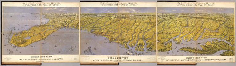
Author
Bachmann, John
Full Title
Panorama of the Seat of War. Birds Eye View Of Virginia, Maryland Delaware And The District Of Columbia. John Bachmann, Publisher, 115 & 117 Nassau St., New York. Entered ... 1861 by John Bachmann ... New York. Drawn from Nature and Lith. by John Bachmann.
List No
0043.001
Note
1st issue; a 2nd issue shows smoke at Manassas. This view joins with the North and South Carolina view and the Florida and Georgia view to form one continuous panorama of the east coast of the Confederacy. Full color. Bound in black leather covers 38x3
Author
Bachmann, John
Full Title
Panorama of the Seat of War. Birds Eye View Of North And South Carolina And Part Of Georgia. John Bachmann, Publisher, 115 & 117 Nassau St., New York. Entered ... 1861 by John Bachmann ... New York. Drawn from Nature and Lith. by John Bachmann.
List No
2664.001
Note
Shows shelling of Ft. Hatteras. Stephenson shows an earlier issue (304.5) that does not have Bachmann's name as publisher, nor the phrase "drawn from nature and lith. by John Bachmann." Full color. Bound in black leather covers 38x30 with "North & South Carolina, Part of Georgia. G.G.W." stamped in gold.
Author
Bachmann, John
Full Title
(Composite of) Panorama of the Seat of War. Birds eye view of Florida and part of Georgia and Alabama .. North and South Carolina and part of Georgia .. Virginia, Maryland, Delaware and the District of Columbia. John Bachmann, Publisher, 115 & 117 Nassau St., New York. Entered ... 1861 by John Bachmann ... New York. Drawn from Nature and Lith. by John Bachmann.
List No
5491.000
Note
Composite map image from three separate issues.
Author
Burr, David H., 1803-1875
Full Title
Map of North And South Carolina Exhibiting the Post Offices, Post Roads, Canals, Rail Roads, &c. By David H. Burr. (Late Topographer to the Post Office.) Geographer to the House of Representatives of the U.S. John Arrowsmith. Entered ... July 10th, 1839, by David H. Burr ... District of Columbia.
List No
0104.006
Note
In full color by county. Postal routes by coach, stage, sulkey, cross, rail roads and canals shown. In 8 sections mounted on linen. Label on back states "No. 6. North & South Carolina."
Author
Burr, David H., 1803-1875
Full Title
Map of Virginia, Maryland and Delaware Exhibiting the Post Offices, Post Roads, Canals, Rail Roads, &c. By David H. Burr. (Late Topographer to the Post Office.) Geographer to the House of Representatives of the U.S. John Arrowsmith. Entered ... July 10th, 1839, by David H. Burr ... District of Columbia.
List No
0104.005
Note
In full color by county. Postal routes by coach, stage, sulkey, cross, rail roads and canals shown. In 8 sections mounted on linen. Label on back states "No. 5. Delaware, Maryland, Virginia."
|