Full Title
154. Composition of church membership of the states and territories: 1890. Julius Bien & Co. Lith., N.Y. (1898)
List No
1873.035
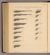
Note
Color lithographed chart. "The area of the circle represents in each case the entire church membership, the various sectors represent, proportionally, the strength of each denomination."
Full Title
155. Proportion of the Roman Catholics to the aggregate population: 1890. 156. Proportion of the Methodists to the aggregate population: 1890. Julius Bien & Co. Lith., N.Y. (1898)
List No
1873.036
Note
Two color lithographed maps.
Full Title
157. Proportion of the Baptists to the aggregate population: 1890. 158. Proportion of the Lutherans to the aggregate population: 1890. Julius Bien & Co. Lith., N.Y. (1898)
List No
1873.037
Note
Two color lithographed maps.
Full Title
159. Proportion of the Presbyterians to the aggregate population: 1890. 160. Proportion of the Congregationalists to the aggregate population: 1890. Julius Bien & Co. Lith., N.Y. (1898)
List No
1873.038
Note
Two color lithographed maps.
Full Title
161. Proportion of the Disciples of Christ to the aggregate population: 1890. 162. Proportion of the Episcopalians to the aggregate population: 1890. Julius Bien & Co. Lith., N.Y. (1898)
List No
1873.039
Note
Two color lithographed maps.
Full Title
Distribution of the membership of the principal religious denominations expressed by the proportion which their membership bears to all communicants: 1890. 163. Baptists -- 164. Catholics -- 165. Congregationalists -- 166. Disciples of Christ -- 167. Episcopalians -- 168. Evangelical Association -- 169. Friends -- 170. German Evangelical Synod -- 171. Jews -- 172. Latter Day Saints -- 173. Lutherans -- 174. Methodists -- 175. Presbyterians -- 176. Reformed -- 177. Unitarians -- 178. United Bretheren. Julius Bien & Co. Lith., N.Y. (1898)
List No
1873.040
Note
Sixteen color lithographed maps.
Full Title
209 ... 220. Number of deaths from ... per 1000 deaths from known causes. Julius Bien & Co. Lith., N.Y. (1898)
List No
1873.041
Note
Twelve color lithographed maps. Contents: 209. Consumption -- 210. Pneumonia -- 211. Diarrheal diseases -- 212. Diphtheria -- 213. Croup -- 214. Typhoid fever -- 215. Cancer and tumor -- 216. Malarial fever -- 217. Measles -- 218. Whooping cough -- 219. Scarlet fever -- 220. Heart disease and dropsy.
Full Title
267. Proportion of wage earners in manufactures. 268. Proportion of wage earners in agriculture. Julius Bien & Co. Lith., N.Y. (1898)
List No
1873.042
Note
Two color lithographed maps.
Full Title
272. Distribution of those engaged in certain selected occupations, by color and nationality: 1890. Julius Bien & Co. Lith., N.Y. (1898)
List No
1873.043
Note
Color lithographed chart.
Full Title
285. Average size of farms: 1890. 286. Proportion of improved land to total area: 1890. Julius Bien & Co. Lith., N.Y. (1898)
List No
1873.044
Note
Two color lithographed maps.
Full Title
287. Value of farm products per acre: 1890. 288. Value of farm products per square mile: 1890. Julius Bien & Co. Lith., N.Y. (1898)
List No
1873.045
Note
Two color lithographed maps.
Full Title
291. Yield of wheat per square mile: 1890. 292. Production of wheat per acre of improved land: 1890. 293. Average yield of wheat per acre: 1890. 294. Production of wheat per capita: 1890. Julius Bien & Co. Lith., N.Y. (1898)
List No
1873.046
Note
Four color lithographed maps.
Full Title
297. Yield of Indian corn per square mile: 1890. 298. Production of Indian corn per acre of improved land: 1890. 299. Average yield of Indian corn per acre: 1890. 300. Production of Indian corn per capita: 1890. Julius Bien & Co. Lith., N.Y. (1898)
List No
1873.047
Note
Four color lithographed maps.
Full Title
303. Yield of oats per square mile: 1890. 304. Production of oats per acre of improved land: 1890. 305. Average yield of oats per acre: 1890. 306. Production of oats per capita: 1890. Julius Bien & Co. Lith., N.Y. (1898)
List No
1873.048
Note
Four color lithographed maps.
Full Title
309. Yield of rye per square mile: 1890. 310. Production of rye per acre of improved land: 1890. Julius Bien & Co. Lith., N.Y. (1898)
List No
1873.049
Note
Two color lithographed maps.
Full Title
313. Yield of barley per square mile: 1890. 314. Production of barley per acre of improved land: 1890. Julius Bien & Co. Lith., N.Y. (1898)
List No
1873.050
Note
Two color lithographed maps.
Full Title
317. Production of all grains per acre of improved land: 1890. 320. Production of tobacco in relation to the entire area of tobacco-producing counties: 1890. Julius Bien & Co. Lith., N.Y. (1898)
List No
1873.051
Note
Two color lithographed maps.
Full Title
321. Yield of cotton per square mile: 1890. 322. Average yield of cotton per acre: 1890. Julius Bien & Co. Lith., N.Y. (1898)
List No
1873.052
Note
Two color lithographed maps.
Full Title
324. Production of hay per square mile: 1890. 325. Yield of hay per acre: 1890. Julius Bien & Co. Lith., N.Y. (1898)
List No
1873.053
Note
Two color lithographed maps.
Full Title
330. Location of areas irrigated in 1889. Julius Bien & Co. Lith., N.Y. (1898)
List No
1873.054
Note
Color lithographed map.
Full Title
Manufactures: 1890. Value of product in dollars per head of population. 337. Center of manufactures for the 7th, 8th, 9th, 10th, and 11th censuses. 338. Brick and tile. 339. Carriages and wagons. 340. Chemicals production. 341. Clay and pottery products. 342. Coke. Julius Bien & Co. Lith., N.Y. (1898)
List No
1873.055
Note
Six color lithographed maps.
Full Title
Manufactures: 1890. Value of product in dollars per head of population. 343. Cotton. 344. Lumber. 345. Glass. 346. Hosiery and knit goods. 347. Leather. 348. Paper. Julius Bien & Co. Lith., N.Y. (1898)
List No
1873.056
Note
Six color lithographed maps.
Full Title
Manufactures: 1890. Value of product in dollars per head of population. 349. Refining of petroleum. 350. Shipbuilding. 351. Silk and silk goods. 352. Slaughtering and meatpacking wholesale. 353. Woolen goods. 354. Worsted goods. Julius Bien & Co. Lith., N.Y. (1898)
List No
1873.057
Note
Six color lithographed maps.
Full Title
366. Production of coal per square mile: 1890. 367. Localities producing iron ore in 1889 and the varieties of ore produced. Julius Bien & Co. Lith., N.Y. (1898)
List No
1873.058
Note
Two color lithographed maps. Iron ore map shows producing areas for red hematite, brown hematite, magnetite and carbonate.
Full Title
370. Navigable rivers and principal transportation routes on the sea coast and Great Lakes: 1890. Julius Bien & Co. Lith., N.Y. (1898)
List No
1873.059
Note
Color lithographed map.
Full Title
372. Railroad systems of the United States: 1890. Julius Bien & Co. Lith., N.Y. (1898)
List No
1873.060
Note
Color lithographed map.
Full Title
377. True value of real and personal property per capita: 1890. 381. True valuation of real estate and improvements thereon per acre: 1890. Julius Bien & Co. Lith., N.Y. (1898)
List No
1873.061
Note
Two color lithographed maps.
Full Title
382. True valuation of real estate and improvements thereon per capita: 1890. 383. Assessed valuation of real and personal property per capita: 1890. Julius Bien & Co. Lith., N.Y. (1898)
List No
1873.062
Note
Two color lithographed maps.
Full Title
385. Taxation on real and personal property per capita: 1890. 398. Distribution per capita of the combined county, municipal and school district indebtedness less sinking fund, 1890. Julius Bien & Co. Lith., N.Y. (1898)
List No
1873.063
Note
Two color lithographed maps.
Author
[Gannett, Henry, 1846-1914, United States. Census Office]
Full Title
(Covers to) Twelfth census of the United States, taken in the year 1900. William R. Merriam, Director. Statistical atlas. Prepared under the supervision of Henry Gannett, Geographer of the Twelfth Census. Washington: United States Census Office. 1903.
List No
2152A
Note
Bound in blue linen with "Statistical Atlas of the United States, 1900" on the cover.
Author
[Gannett, Henry, 1846-1914, United States. Census Office]
Full Title
(Title Page to) Twelfth census of the United States, taken in the year 1900. William R. Merriam, Director. Statistical atlas. Prepared under the supervision of Henry Gannett, Geographer of the Twelfth Census. Washington: United States Census Office. 1903.
List No
2152B
Note
Maps by Julius Bien & Co. The maps are in color and overwhelmingly thematic in nature covering the topics of population, vital statistics, agriculture, and manufacturing. Bound in blue linen with "Statistical Atlas of the United States, 1900" on the cover.
Author
[Gannett, Henry, 1846-1914, United States. Census Office]
Full Title
(Contents to) Twelfth census of the United States, taken in the year 1900. William R. Merriam, Director. Statistical atlas. Prepared under the supervision of Henry Gannett, Geographer of the Twelfth Census. Washington: United States Census Office. 1903.
List No
2152C
Note
Contents.
Author
[Gannett, Henry, 1846-1914, United States. Census Office]
Full Title
(Contents to) Twelfth census of the United States, taken in the year 1900. William R. Merriam, Director. Statistical atlas. Prepared under the supervision of Henry Gannett, Geographer of the Twelfth Census. Washington: United States Census Office. 1903.
List No
2152D
Note
Contents (continued)
Author
[Gannett, Henry, 1846-1914, United States. Census Office]
Full Title
(Contents to) Twelfth census of the United States, taken in the year 1900. William R. Merriam, Director. Statistical atlas. Prepared under the supervision of Henry Gannett, Geographer of the Twelfth Census. Washington: United States Census Office. 1903.
List No
2152E
Note
List of illustrations.
Author
[Gannett, Henry, 1846-1914, United States. Census Office]
Full Title
(Contents to) Twelfth census of the United States, taken in the year 1900. William R. Merriam, Director. Statistical atlas. Prepared under the supervision of Henry Gannett, Geographer of the Twelfth Census. Washington: United States Census Office. 1903.
List No
2152F
Note
List of illustrations (continued)
Author
[Gannett, Henry, 1846-1914, United States. Census Office]
Full Title
(Contents to) Twelfth census of the United States, taken in the year 1900. William R. Merriam, Director. Statistical atlas. Prepared under the supervision of Henry Gannett, Geographer of the Twelfth Census. Washington: United States Census Office. 1903.
List No
2152G
Note
List of illustrations (continued)
Author
[Gannett, Henry, 1846-1914, United States. Census Office]
Full Title
(Contents to) Twelfth census of the United States, taken in the year 1900. William R. Merriam, Director. Statistical atlas. Prepared under the supervision of Henry Gannett, Geographer of the Twelfth Census. Washington: United States Census Office. 1903.
List No
2152H
Note
List of illustrations (continued)
Author
[Gannett, Henry, 1846-1914, United States. Census Office]
Full Title
(Contents to) Twelfth census of the United States, taken in the year 1900. William R. Merriam, Director. Statistical atlas. Prepared under the supervision of Henry Gannett, Geographer of the Twelfth Census. Washington: United States Census Office. 1903.
List No
2152I
Note
List of illustrations (continued)
Author
[Gannett, Henry, 1846-1914, United States. Census Office]
Full Title
(Contents to) Twelfth census of the United States, taken in the year 1900. William R. Merriam, Director. Statistical atlas. Prepared under the supervision of Henry Gannett, Geographer of the Twelfth Census. Washington: United States Census Office. 1903.
List No
2152J
Note
List of illustrations (continued)
Author
[Gannett, Henry, 1846-1914, United States. Census Office]
Full Title
(Contents to) Twelfth census of the United States, taken in the year 1900. William R. Merriam, Director. Statistical atlas. Prepared under the supervision of Henry Gannett, Geographer of the Twelfth Census. Washington: United States Census Office. 1903.
List No
2152K
Note
List of illustrations (continued)
Author
[Gannett, Henry, 1846-1914, United States. Census Office]
Full Title
(Contents to) Twelfth census of the United States, taken in the year 1900. William R. Merriam, Director. Statistical atlas. Prepared under the supervision of Henry Gannett, Geographer of the Twelfth Census. Washington: United States Census Office. 1903.
List No
2152L
Note
List of illustrations (continued) and Letter of transmittal.
Full Title
Accessions of territory from the Treaty of Peace to the Gadsden Purchase. (Prepared under the supervision of Henry Gannett, Geographer of the Twelfth Census. United States Census Office, 1903). Julius Bien & Co., N.Y.
List No
2152.001
Note
Color lithographed map.
Full Title
Distribution of the population: 1790. (Prepared under the supervision of Henry Gannett, Geographer of the Twelfth Census. United States Census Office, 1903). Julius Bien & Co., N.Y.
List No
2152.002
Note
Color lithographed map.
Full Title
Distribution of the population: 1800. (Prepared under the supervision of Henry Gannett, Geographer of the Twelfth Census. United States Census Office, 1903). Julius Bien & Co., N.Y.
List No
2152.003
Note
Color lithographed map.
Full Title
Distribution of the population east of the 100th meridian: 1810. (Prepared under the supervision of Henry Gannett, Geographer of the Twelfth Census. United States Census Office, 1903). Julius Bien & Co., N.Y.
List No
2152.004
Note
Color lithographed map.
Full Title
Distribution of the population east of the 100th meridian: 1820. (Prepared under the supervision of Henry Gannett, Geographer of the Twelfth Census. United States Census Office, 1903). Julius Bien & Co., N.Y.
List No
2152.005
Note
Color lithographed map.
Full Title
Distribution of the population east of the 100th meridian: 1830. (Prepared under the supervision of Henry Gannett, Geographer of the Twelfth Census. United States Census Office, 1903). Julius Bien & Co., N.Y.
List No
2152.006
Note
Color lithographed map.
Full Title
Distribution of the population east of the 100th meridian: 1840. (Prepared under the supervision of Henry Gannett, Geographer of the Twelfth Census. United States Census Office, 1903). Julius Bien & Co., N.Y.
List No
2152.007
Note
Color lithographed map.
Full Title
Distribution of the population east of the 100th meridian: 1850. (Prepared under the supervision of Henry Gannett, Geographer of the Twelfth Census. United States Census Office, 1903). Julius Bien & Co., N.Y.
List No
2152.008
Note
Color lithographed map.
Full Title
Distribution of the population east of the 100th meridian: 1860. (Prepared under the supervision of Henry Gannett, Geographer of the Twelfth Census. United States Census Office, 1903). Julius Bien & Co., N.Y.
List No
2152.009
Note
Color lithographed map.
Full Title
Distribution of the population, excluding Indians not taxed: 1870. (Prepared under the supervision of Henry Gannett, Geographer of the Twelfth Census. United States Census Office, 1903). Julius Bien & Co., N.Y.
List No
2152.010
Note
Color lithographed map.
Full Title
Distribution of the population, excluding Indians not taxed: 1880. (Prepared under the supervision of Henry Gannett, Geographer of the Twelfth Census. United States Census Office, 1903). Julius Bien & Co., N.Y.
List No
2152.011
Note
Color lithographed map.
Full Title
Distribution of the population, excluding Indians not taxed: 1890. (Prepared under the supervision of Henry Gannett, Geographer of the Twelfth Census. United States Census Office, 1903). Julius Bien & Co., N.Y.
List No
2152.012
Note
Color lithographed map.
Full Title
Distribution of the population: 1900. (Prepared under the supervision of Henry Gannett, Geographer of the Twelfth Census. United States Census Office, 1903). Julius Bien & Co., N.Y.
List No
2152.013
Note
Color lithographed map.
Full Title
Increase of population in the United States and the principal countries of Europe from 1800 to 1900. (Prepared under the supervision of Henry Gannett, Geographer of the Twelfth Census. United States Census Office, 1903). Julius Bien & Co., N.Y.
List No
2152.014
Note
Lithographed chart.
Author
Gannett, Henry, 1846-1914
Full Title
Sketch map showing the center of population June 1st 1900. Compiled by Henry Gannett, Geographer. (United States Census Office, 1903). Julius Bien & Co., N.Y.
List No
2152.015
Note
Lithographed map of part of Indiana.
Author
Gannett, Henry, 1846-1914
Full Title
Map showing the position of the center of population at the close of each decade from 1790 to 1900 and the location of the median point in 1880, 1890 and 1900. Compiled by Henry Gannett, Geographer. (United States Census Office, 1903). Julius Bien & Co., N.Y.
List No
2152.016
Note
Lithographed map of Ohio and West Virginia and parts of Virginia, Maryland, Pennsylvania, Kentucky, Indiana and Michigan.
Full Title
1. Total and urban population at each census. 2. Density of population at each census, excluding Alaska and Hawaii. 3. Proportion of urban to total population at each census. (Prepared under the supervision of Henry Gannett, Geographer of the Twelfth Census. United States Census Office, 1903)
List No
2152.017
Note
Three lithographed graphs.
Full Title
Total population of each state and territory at each census. Maine, New Hampshire, Vermont, Massachusetts, Rhode Island, Connecticut, New York, New Jersey, Pennsylvania, Delaware, Maryland, Dist. of Columbia, Virginia, West Virginia, N. Carolina, S. Carolina, Georgia, Florida, Alabama, Mississippi, Louisiana, Texas, Kentucky, Tennessee, Arkansas, Indian Ter., Oklahoma. (Prepared under the supervision of Henry Gannett, Geographer of the Twelfth Census. United States Census Office, 1903). Julius Bien & Co., N.Y.
List No
2152.018
Note
Lithographed graphs.
Full Title
Total population of each state and territory at each census. Ohio, Indiana, Michigan, Illinois, Wisconsin, Minnesota, Iowa, Missouri, N. Dakota, S. Dakota, Nebraska, Kansas, Montana, Wyoming, Colorado, New Mexico, Arizona, Utah, Nevada, Idaho, Washington, Oregon, California, Alaska, Hawaii. (Prepared under the supervision of Henry Gannett, Geographer of the Twelfth Census. United States Census Office, 1903. Julius Bien & Co., N.Y.)
List No
2152.019
Note
Lithographed graphs.
Full Title
Proportion of urban to total population, by states and territories, at each census. (Prepared under the supervision of Henry Gannett, Geographer of the Twelfth Census. United States Census Office, 1903). Julius Bien & Co., N.Y.
List No
2152.020
Note
Lithographed graphs.
Full Title
Rank of states and territories in population at each census. (Prepared under the supervision of Henry Gannett, Geographer of the Twelfth Census. United States Census Office, 1903). Julius Bien & Co., N.Y.
List No
2152.021
Note
Color lithographed chart.
Full Title
Rank of the most populous cities at each census. (Prepared under the supervision of Henry Gannett, Geographer of the Twelfth Census. United States Census Office, 1903). Julius Bien & Co., N.Y.
List No
2152.022
Note
Color lithographed chart.
Full Title
Total population of great cities at each census. (Prepared under the supervision of Henry Gannett, Geographer of the Twelfth Census. United States Census Office, 1903)
List No
2152.023
Note
Lithographed graphs.
Full Title
1. Total and urban population by states and territories: 1900. 2. Density of population by states and territories: 1900. 3. Total population of cities of more than 100,000 inhabitants: 1900. (Prepared under the supervision of Henry Gannett, Geographer of the Twelfth Census. United States Census Office, 1903). Julius Bien & Co., N.Y.
List No
2152.024
Note
Three lithographed charts.
Author
Gannett, Henry, 1846-1914
Full Title
Density of increase of population of the United States 1890 to 1900. Compiled by Henry Gannett, Geographer. (United States Census Office, 1903). Julius Bien & Co., N.Y.
List No
2152.025
Note
Color lithographed map.
Author
Gannett, Henry, 1846-1914
Full Title
Proportion of population in cities and towns of more than 2000 inhabitants at the twelfth census 1900. Compiled by Henry Gannett, Geographer. (United States Census Office, 1903). Julius Bien & Co., N.Y.
List No
2152.026
Note
Color lithographed map.
Full Title
1. Density of population: 1900. 2. Proportion of urban to total population: 1900. 3. Proportion of increase of total population: 1890 to 1900. 4. Proportion of whites of foreign parentage to total population: 1900. 5. Density of increase of population: 1890 to 1900. 6. Numerical gain or loss in foreign born: 1900. (Prepared under the supervision of Henry Gannett, Geographer of the Twelfth Census. United States Census Office, 1903. Julius Bien & Co., N.Y.)
List No
2152.027
Note
Six color lithographed maps.
Author
Gannett, Henry, 1846-1914
Full Title
Proportion of increase of total population 1890 to 1900. Compiled by Henry Gannett, Geographer. (United States Census Office, 1903). Julius Bien & Co., N.Y.
List No
2152.028
Note
Color lithographed map.
Author
Gannett, Henry, 1846-1914
Full Title
The predominating sex of the United States at the twelfth census, 1900. Compiled by Henry Gannett, Geographer. (United States Census Office, 1903). Julius Bien & Co., N.Y.
List No
2152.029
Note
Color lithographed map.
Full Title
Age and sex, in percentages of each element of the population. Total population ... White population ... Colored population, 1900, 1890, 1880. (Prepared under the supervision of Henry Gannett, Geographer of the Twelfth Census. United States Census Office, 1903). Julius Bien & Co., N.Y.
List No
2152.030
Note
Nine lithographed graphs.
Full Title
Age and sex, in percentages of each element of the population. Native white population ... Foreign white population ... Native white of native parents ... Indians ... 1900, 1890, 1880. (Prepared under the supervision of Henry Gannett, Geographer of the Twelfth Census. United States Census Office, 1903). Julius Bien & Co., N.Y.
List No
2152.031
Note
Nine lithographed graphs.
Full Title
1. Age and sex, in percentages of each element of the population. Native white of foreign parents, 1900, 1890. Negro, 1900. 2. Conjugal condition: 1900. Total population, Native white of native parents, Native white of foreign parents, Foreign white, Negro. (Prepared under the supervision of Henry Gannett, Geographer of the Twelfth Census. United States Census Office, 1903). Julius Bien & Co., N.Y.
List No
2152.032
Note
Eight lithographed graphs.
Full Title
Aggregate population by age and sex: 1900. Alabama ... Montana. (Prepared under the supervision of Henry Gannett, Geographer of the Twelfth Census. United States Census Office, 1903). Julius Bien & Co., N.Y.
List No
2152.033
Note
Twenty-seven lithographed graphs.
Full Title
Aggregate population by age and sex: 1900. Nebraska ... Wyoming. (Prepared under the supervision of Henry Gannett, Geographer of the Twelfth Census. United States Census Office, 1903). Julius Bien & Co., N.Y.
List No
2152.034
Note
Twenty-four lithographed graphs.
Full Title
Native white population by age and sex: 1900. Alabama ... Montana. (Prepared under the supervision of Henry Gannett, Geographer of the Twelfth Census. United States Census Office, 1903). Julius Bien & Co., N.Y.
List No
2152.035
Note
Twenty-seven lithographed graphs.
Full Title
Native white population by age and sex: 1900. Nebraska ... Wyoming. (Prepared under the supervision of Henry Gannett, Geographer of the Twelfth Census. United States Census Office, 1903). Julius Bien & Co., N.Y.
List No
2152.036
Note
Twenty-four lithographed graphs.
Full Title
Foreign white population by age and sex: 1900. Alabama ... Montana. (Prepared under the supervision of Henry Gannett, Geographer of the Twelfth Census. United States Census Office, 1903). Julius Bien & Co., N.Y.
List No
2152.037
Note
Twenty-seven lithographed graphs.
Full Title
Foreign white population by age and sex: 1900. Nebraska ... Wyoming. (Prepared under the supervision of Henry Gannett, Geographer of the Twelfth Census. United States Census Office, 1903). Julius Bien & Co., N.Y.
List No
2152.038
Note
Twenty-four lithographed graphs.
Full Title
Negro population by age and sex: 1900. Alabama ... Nebraska. (Prepared under the supervision of Henry Gannett, Geographer of the Twelfth Census. United States Census Office, 1903). Julius Bien & Co., N.Y.
List No
2152.039
Note
Twenty-seven lithographed graphs.
Full Title
Negro population by age and sex: 1900. Nevada ... Wyoming. (Prepared under the supervision of Henry Gannett, Geographer of the Twelfth Census. United States Census Office, 1903). Julius Bien & Co., N.Y.
List No
2152.040
Note
Twenty-three lithographed graphs.
Full Title
Elements of the population: 1900. (Prepared under the supervision of Henry Gannett, Geographer of the Twelfth Census. United States Census Office, 1903). Julius Bien & Co., N.Y.
List No
2152.041
Note
Three lithographed charts.
Full Title
The total population and its elements at each census. (Prepared under the supervision of Henry Gannett, Geographer of the Twelfth Census. United States Census Office, 1903). Julius Bien & Co., N.Y.
List No
2152.042
Note
Color lithographed pie charts. Elements: native white of native parents, native white of foreign parents, foreign white, colored and native white.
Full Title
Constituents of the population of states and territories: 1900. (Prepared under the supervision of Henry Gannett, Geographer of the Twelfth Census. United States Census Office, 1903). Julius Bien & Co., N.Y.
List No
2152.043
Note
Color lithographed chart. Constituents are native white of native parents, native white of foreign parents, foreign white, Indians, Chinese and Japanese, and Negro.
Full Title
Constituents of the population of cities of more than 100,000 inhabitants: 1900. (Prepared under the supervision of Henry Gannett, Geographer of the Twelfth Census. United States Census Office, 1903). Julius Bien & Co., N.Y.
List No
2152.044
Note
Color lithographed chart. Constituents are native white of native parents, native white of foreign parents, foreign white, Chinese and Japanese, and Negro.
Full Title
Constituents of the male population of militia age: 1900. (Prepared under the supervision of Henry Gannett, Geographer of the Twelfth Census. United States Census Office, 1903). Julius Bien & Co., N.Y.
List No
2152.045
Note
Color lithographed chart. Constituents are native white of native parents, native white of foreign parents, foreign white, Indian, Chinese and Japanese, and Negro.
Full Title
Constituents of the male population of voting age: 1900. (Prepared under the supervision of Henry Gannett, Geographer of the Twelfth Census. United States Census Office, 1903). Julius Bien & Co., N.Y.
List No
2152.046
Note
Color lithographed chart. Constituents are native white of native parents, native white of foreign parents, foreign white, Indian, Chinese and Japanese, and Negro.
Full Title
Composition of the population of states and territories including resident natives, native immigrants and foreign born, with per cent of native emigrants: 1900. (Prepared under the supervision of Henry Gannett, Geographer of the Twelfth Census. United States Census Office, 1903). Julius Bien & Co., N.Y.
List No
2152.047
Note
Color lithographed chart. Components are resident natives, native immigrants, foreign born and native emigrants.
Full Title
State of birth of the native population by states and territories: 1900. (Prepared under the supervision of Henry Gannett, Geographer of the Twelfth Census. United States Census Office, 1903). Julius Bien & Co., N.Y.
List No
2152.048
Note
Color lithographed chart. The two categories are: native to state and all other natives.
Full Title
Distribution of persons born in each specified state and territory who are living in other states and territories: 1900. (Prepared under the supervision of Henry Gannett, Geographer of the Twelfth Census. United States Census Office, 1903). Julius Bien & Co., N.Y.
List No
2152.049
Note
Color lithographed chart.
Full Title
Net results of migration by states and territories: 1900. Interstate migration, all migration. (Prepared under the supervision of Henry Gannett, Geographer of the Twelfth Census. United States Census Office, 1903). Julius Bien & Co., N.Y.
List No
2152.050
Note
Lithographed chart.
Full Title
Interstate migration: 1900. Emigrants, immigrants. (Prepared under the supervision of Henry Gannett, Geographer of the Twelfth Census. United States Census Office, 1903). Julius Bien & Co., N.Y.
List No
2152.051
Note
Lithographed chart.
Author
Gannett, Henry, 1846-1914
Full Title
Sketch map showing the position of the center of the Negro population and the median point in 1880, 1890 and 1900. Compiled by Henry Gannett, Geographer. (United States Census Office, 1903). Julius Bien & Co., N.Y.
List No
2152.052
Note
Lithographed map. Covers parts of Alabama, Georgia and Tennessee. Also shows counties, cities, railroads, etc.
Full Title
1. Negro population by states and territories: 1900. 2. Percentage of the native white of native parentage and of the Negro under 1 year of age by states and territories: 1900. (Prepared under the supervision of Henry Gannett, Geographer of the Twelfth Census. United States Census Office, 1903). Julius Bien & Co., N.Y.
List No
2152.053
Note
Two lithographed charts.
Full Title
Percentage of white and Negro population in certain states at each census. (Prepared under the supervision of Henry Gannett, Geographer of the Twelfth Census. United States Census Office, 1903). Julius Bien & Co., N.Y.
List No
2152.054
Note
Fifteen graphs. Cover Delaware, Maryland, District of Columbia, Virginia & West Virginia, North Carolina, South Carolina, Georgia, Florida, Kentucky, Tennessee, Alabama, Mississippi, Louisiana, Arkansas and Texas.
Author
Gannett, Henry, 1846-1914
Full Title
Density of Negro population of the United States at the twelfth census, 1900. Compiled by Henry Gannett, Geographer. (United States Census Office, 1903). Julius Bien & Co., N.Y.
List No
2152.055
Note
Color lithographed map.
Author
Gannett, Henry, 1846-1914
Full Title
Proportion of Negro to total population of the United States at the twelfth census, 1900. Compiled by Henry Gannett, Geographer. (United States Census Office, 1903). Julius Bien & Co., N.Y.
List No
2152.056
Note
Color lithographed map.
Full Title
Foreign born at each census, with the proportion of each leading nationality: 1850 to 1900. (Prepared under the supervision of Henry Gannett, Geographer of the Twelfth Census. United States Census Office, 1903). Julius Bien & Co., N.Y.
List No
2152.057
Note
Six color lithographed pie charts.
Full Title
1. Total foreign born at each census with the number of each leading nationality: 1850 to 1900. 2. Proportion which each of the leading nationalities bears to the total foreign born at each census: 1850 to 1900. (Prepared under the supervision of Henry Gannett, Geographer of the Twelfth Census. United States Census Office, 1903). Julius Bien & Co., N.Y.
List No
2152.058
Note
Two color lithographed charts.
Full Title
Foreign born of each leading nationality at each census: 1850 to 1900. (Prepared under the supervision of Henry Gannett, Geographer of the Twelfth Census. United States Census Office, 1903). Julius Bien & Co., N.Y.
List No
2152.059
Note
Twelve lithographed graphs.
Full Title
1. Foreign born population, by states and territories: 1900. 2. Percentage of aliens in the total foreign born of each specified nativity: 1900. 3. Percentage of aliens in the foreign born males 21 years of age and over in cities having 100,000 inhabitants or more: 1900. (Prepared under the supervision of Henry Gannett, Geographer of the Twelfth Census. United States Census Office, 1903). Julius Bien & Co., N.Y.
List No
2152.060
Note
Three lithographed graphs.
Author
Gannett, Henry, 1846-1914
Full Title
Density of foreign born population of the United States at the twelfth census, 1900. Compiled by Henry Gannett, Geographer. (United States Census Office, 1903). Julius Bien & Co., N.Y.
List No
2152.061
Note
Color lithographed map.
Author
Gannett, Henry, 1846-1914
Full Title
Proportion of foreign born to total population of the United States at the twelfth census, 1900. Compiled by Henry Gannett, Geographer. (United States Census Office, 1903). Julius Bien & Co., N.Y.
List No
2152.062
Note
Color lithographed map.
Full Title
Proportion of foreign born of each leading nationality, by states and territories: 1900. (Prepared under the supervision of Henry Gannett, Geographer of the Twelfth Census. United States Census Office, 1903). Julius Bien & Co., N.Y.
List No
2152.063
Note
Color lithographed chart.
Full Title
Proportion of foreign born of each leading nationality, in cities of 100,000 and over: 1900. (Prepared under the supervision of Henry Gannett, Geographer of the Twelfth Census. United States Census Office, 1903). Julius Bien & Co., N.Y.
List No
2152.064
Note
Color lithographed chart.
Full Title
1. Density of natives of Germany: 1900. 2. Proportion of natives of Germany to total population: 1900. (Prepared under the supervision of Henry Gannett, Geographer of the Twelfth Census. United States Census Office, 1903). Julius Bien & Co., N.Y.
List No
2152.065
Note
Two color lithographed maps.
Full Title
1. Density of natives of Ireland: 1900. 2. Proportion of natives of Ireland to total population: 1900. (Prepared under the supervision of Henry Gannett, Geographer of the Twelfth Census. United States Census Office, 1903). Julius Bien & Co., N.Y.
List No
2152.066
Note
Two color lithographed maps.
Full Title
1. Density of natives of Great Britain: 1900. 2. Proportion of natives of Great Britain to total population: 1900. (Prepared under the supervision of Henry Gannett, Geographer of the Twelfth Census. United States Census Office, 1903). Julius Bien & Co., N.Y.
List No
2152.067
Note
Two color lithographed maps.
Full Title
1. Density of natives of Canada: 1900. 2. Proportion of natives of Canada to total population: 1900. (Prepared under the supervision of Henry Gannett, Geographer of the Twelfth Census. United States Census Office, 1903). Julius Bien & Co., N.Y.
List No
2152.068
Note
Two color lithographed maps.
Full Title
1. Density of Scandinavians: 1900. 2. Proportion of Scandinavians to total population: 1900. (Prepared under the supervision of Henry Gannett, Geographer of the Twelfth Census. United States Census Office, 1903). Julius Bien & Co., N.Y.
List No
2152.069
Note
Two color lithographed maps.
Full Title
Geographical distribution of groups of nations: 1900 and 1890. 1. Teutons. 2. Greco-Latins. 3. Irish. 4. Slavs. (Prepared under the supervision of Henry Gannett, Geographer of the Twelfth Census. United States Census Office, 1903). Julius Bien & Co., N.Y.
List No
2152.070
Note
Four lithographed graphs.
Full Title
Geographical distribution of groups of nations: 1900 and 1890. 1. Scandinavians. 2. British. 3. British Americans. 4. Asiatics. (Prepared under the supervision of Henry Gannett, Geographer of the Twelfth Census. United States Census Office, 1903). Julius Bien & Co., N.Y.
List No
2152.071
Note
Four lithographed graphs.
Full Title
1. Density of foreign born population: 1900. 2. Density of Negro population: 1900. 3. Proportion of foreign born to total population: 1900. 4. Proportion of Negro to total population: 1900. 5. Increase and decrease of the foreign born: 1890 to 1900. 6. Increase and decrease of the Negro population: 1890 to 1900. (Prepared under the supervision of Henry Gannett, Geographer of the Twelfth Census. United States Census Office, 1903. Julius Bien & Co., N.Y.)
List No
2152.072
Note
Six color lithographed maps.
Full Title
1. Distribution of natives of certain foreign countries: 1900. 2. Percentage of each nativity in cities of 25,000 inhabitants or more: 1900. (Prepared under the supervision of Henry Gannett, Geographer of the Twelfth Census. United States Census Office, 1903). Julius Bien & Co., N.Y.
List No
2152.073
Note
Nine lithographed graphs. "1" contents: Germany -- Ireland -- Canada and New Foundland -- Great Britain -- Norway, Sweden and Denmark -- Poland -- Russia -- Italy.
Full Title
1. White population of foreign parentage, including foreign born whites, by states and territories: 1900. 2. Proportion of aliens to total foreign born males of voting age in each specified nativity: 1900. (Prepared under the supervision of Henry Gannett, Geographer of the Twelfth Census. United States Census Office, 1903). Julius Bien & Co., N.Y.
List No
2152.074
Note
Two lithographed graphs.
Author
Gannett, Henry, 1846-1914
Full Title
Proportion of whites of foreign parentage to total population of the United States at the twelfth census, 1900. Compiled by Henry Gannett, Geographer. (United States Census Office, 1903). Julius Bien & Co., N.Y.
List No
2152.075
Note
Color lithographed map.
Full Title
1. The predominating sex: 1900. 2. Proportion of divorced to married: 1900. 3. Gain or loss as the result of all migration: 1900. 4. Proportion of aliens to foreign born males 21 years of age and over: 1900. 5. Gain or loss as the result of interstate migration: 1900. 6. Proportion of foreign born whites 10 years of age and over who cannot speak English: 1900. (Prepared under the supervision of Henry Gannett, Geographer of the Twelfth Census. United States Census Office, 1903). Julius Bien & Co., N.Y.
List No
2152.076
Note
Six color lithographed maps.
Full Title
Conjugal condition of the population by age and sex, in proportions of the total number of each age group. Aggregate population: 1900. Aggregate population: 1890. Native white of native parents: 1900. Native white of foreign parents: 1900. (Prepared under the supervision of Henry Gannett, Geographer of the Twelfth Census. United States Census Office, 1903). Julius Bien & Co., N.Y.
List No
2152.077
Note
Four color lithographed graphs.
Full Title
Conjugal condition of the population by age and sex, in proportions of the total number of each age group: 1900. Foreign white. Negro. Indian. Chinese and Japanese. (Prepared under the supervision of Henry Gannett, Geographer of the Twelfth Census. United States Census Office, 1903). Julius Bien & Co., N.Y.
List No
2152.078
Note
Four color lithographed graphs.
Author
Gannett, Henry, 1846-1914
Full Title
Proportion of illiterates among native white voters of the United States at the twelfth census, 1900. Compiled by Henry Gannett, Geographer. (United States Census Office, 1903). Julius Bien & Co., N.Y.
List No
2152.079
Note
Color lithographed map.
Author
Gannett, Henry, 1846-1914
Full Title
Proportion of illiterates among Negro voters of the United States at the twelfth census, 1900. Compiled by Henry Gannett, Geographer. (United States Census Office, 1903). Julius Bien & Co., N.Y.
List No
2152.080
Note
Color lithographed map.
Full Title
Males of voting age by color and nativity, and by illiteracy: 1900. (Prepared under the supervision of Henry Gannett, Geographer of the Twelfth Census. United States Census Office, 1903). Julius Bien & Co., N.Y.
List No
2152.081
Note
Color lithographed chart.
Full Title
Proportion of illiterates among the total population 10 years of age and over (by state). 1900. 1890. (Prepared under the supervision of Henry Gannett, Geographer of the Twelfth Census. United States Census Office, 1903). Julius Bien & Co., N.Y.
List No
2152.082
Note
Two lithographed graphs.
Full Title
Proportion of illiterates among the native white population 10 years of age and over (by state). 1900. 1890. (Prepared under the supervision of Henry Gannett, Geographer of the Twelfth Census. United States Census Office, 1903). Julius Bien & Co., N.Y.
List No
2152.083
Note
Two lithographed graphs.
Full Title
Proportion of illiterates among the foreign white population 10 years of age and over (by state). 1900. 1890. (Prepared under the supervision of Henry Gannett, Geographer of the Twelfth Census. United States Census Office, 1903). Julius Bien & Co., N.Y.
List No
2152.084
Note
Two lithographed graphs.
Full Title
Proportion of illiterates among the Negro population 10 years of age and over (by state). 1900. 1890. (Prepared under the supervision of Henry Gannett, Geographer of the Twelfth Census. United States Census Office, 1903). Julius Bien & Co., N.Y.
List No
2152.085
Note
Two lithographed graphs.
Full Title
Proportion of white persons of foreign parentage 10 years of age and over, who cannot speak English: 1900 (by state. Prepared under the supervision of Henry Gannett, Geographer of the Twelfth Census. United States Census Office, 1903). Julius Bien & Co., N.Y.
List No
2152.086
Note
Lithographed graph.
Full Title
Classification of the occupations by race and nativity: 1900. (Prepared under the supervision of Henry Gannett, Geographer of the Twelfth Census. United States Census Office, 1903). Julius Bien & Co., N.Y.
List No
2152.087
Note
Color lithographed chart.
Full Title
Proportions by nativity and race of persons engaged in the principal occupations: 1900. (Prepared under the supervision of Henry Gannett, Geographer of the Twelfth Census. United States Census Office, 1903). Julius Bien & Co., N.Y.
List No
2152.088
Note
Color lithographed chart.
Full Title
1. Population 10 years of age and over, by sex, classified as wage earners and non-wage earners: 1900. 2. Population 10 years of age and over, by color and general nativity, classified as wage earners and non-wage earners: 1900. 3. Elements of the population 10 years of age and over, by sex, classified as wage earners and non-wage earners: 1900. Native white of native parents, Native white of foreign parents, Foreign white, Colored. (Prepared under the supervision of Henry Gannett, Geographer of the Twelfth Census. United States Census Office, 1903). Julius Bien & Co., N.Y.
List No
2152.089
Note
Six charts. Lithograph.
Full Title
Proportion of males and females in each class of occupations and in certain occupation groups: 1900. (Prepared under the supervision of Henry Gannett, Geographer of the Twelfth Census. United States Census Office, 1903). Julius Bien & Co., N.Y.
List No
2152.090
Note
Lithographed chart.
Full Title
Proportions of persons engaged in certain groups of occupations to all wage earners: 1900. 1. Agriculture. 2. Manufacturing and mechanical pursuits. 3. Mining and quarrying. 4. Trade and transportation. 5. Domestic and personal service. 6. Professional service. (Prepared under the supervision of Henry Gannett, Geographer of the Twelfth Census. United States Census Office, 1903). Julius Bien & Co., N.Y.
List No
2152.091
Note
Six color lithographed maps.
Full Title
Proportions of persons engaged in each class of occupations: 1900 (by states. Prepared under the supervision of Henry Gannett, Geographer of the Twelfth Census. United States Census Office, 1903). Julius Bien & Co., N.Y.
List No
2152.092
Note
Color lithographed chart.
Full Title
Proportions of persons engaged in each class of occupations: 1890 (by states. Prepared under the supervision of Henry Gannett, Geographer of the Twelfth Census. United States Census Office, 1903). Julius Bien & Co., N.Y.
List No
2152.093
Note
Color lithographed chart.
Full Title
Distribution of wage earners of specified parentage by principal occupations: 1900. 1. Native. 2. Irish. 3. Foreign. 4. German. 5. Negro. 6. French. (Prepared under the supervision of Henry Gannett, Geographer of the Twelfth Census. United States Census Office, 1903). Julius Bien & Co., N.Y.
List No
2152.094
Note
Six graphs. Lithograph.
Full Title
Distribution of wage earners of specified parentage by principal occupations: 1900. 1. Norwegian. 2. Canadian (English). 3. Danish. 4. Canadian (French). 5. Swedish. 6. British. (Prepared under the supervision of Henry Gannett, Geographer of the Twelfth Census. United States Census Office, 1903). Julius Bien & Co., N.Y.
List No
2152.095
Note
Six graphs. Lithograph.
Full Title
Distribution of wage earners of specified parentage by principal occupations: 1900. 1. Austrian. 2. Hungarian. 3. Polish. 4. Russian. 5. Italian. 6. Bohemian. (Prepared under the supervision of Henry Gannett, Geographer of the Twelfth Census. United States Census Office, 1903). Julius Bien & Co., N.Y.
List No
2152.096
Note
Six graphs. Lithograph.
Full Title
1. Average number of persons to a family for the United States: 1850 to 1900. 2. Average number of persons to a private family by states and territories: 1900. (Prepared under the supervision of Henry Gannett, Geographer of the Twelfth Census. United States Census Office, 1903). Julius Bien & Co., N.Y.
List No
2152.097
Note
Two charts. Lithograph.
Author
Gannett, Henry, 1846-1914
Full Title
Average size of private families at the twelfth census, 1900. Compiled by Henry Gannett, Geographer. (United States Census Office, 1903). Julius Bien & Co., N.Y.
List No
2152.098
Note
Color lithographed map.
Full Title
Proportion of homes owned free, owned encumbered, and hired: 1900 (by states. Prepared under the supervision of Henry Gannett, Geographer of the Twelfth Census. United States Census Office, 1903). Julius Bien & Co., N.Y.
List No
2152.099
Note
Color lithographed chart.
Full Title
Proportion of farm homes owned free, owned encumbered, and hired: 1900 (by states. Prepared under the supervision of Henry Gannett, Geographer of the Twelfth Census. United States Census Office, 1903. Julius Bien & Co., N.Y.)
List No
2152.100
Note
Color lithographed chart.
Full Title
The death rate due to consumption per 100,000 of population 1900 (New York, New Jersey, New England. Prepared under the supervision of Henry Gannett, Geographer of the Twelfth Census. United States Census Office, 1903). Julius Bien & Co., N.Y.
List No
2152.101
Note
Color lithographed map. New Jersey shown in inset. Relief shown by contours.
Full Title
The death rate due to consumption per 100,000 of population 1900 (Michigan. Prepared under the supervision of Henry Gannett, Geographer of the Twelfth Census. United States Census Office, 1903). Julius Bien & Co., N.Y.
List No
2152.102
Note
Color lithographed map. Relief shown by contours.
Full Title
The death rate due to cancer and tumor per 100,000 of population 1900 (New York, New Jersey, New England. Prepared under the supervision of Henry Gannett, Geographer of the Twelfth Census. United States Census Office, 1903). Julius Bien & Co., N.Y.
List No
2152.103
Note
Color lithographed map. New Jersey shown in inset. Relief shown by contours.
Full Title
The death rate due to cancer and tumor per 100,000 of population 1900 (Michigan. Prepared under the supervision of Henry Gannett, Geographer of the Twelfth Census. United States Census Office, 1903). Julius Bien & Co., N.Y.
List No
2152.104
Note
Color lithographed map. Relief shown by contours.
Full Title
The death rate due to diphtheria and croup per 100,000 of population 1900 (New York, New Jersey, New England. Prepared under the supervision of Henry Gannett, Geographer of the Twelfth Census. United States Census Office, 1903). Julius Bien & Co., N.Y.
List No
2152.105
Note
Color lithographed map. New Jersey shown in inset. Relief shown by contours.
Full Title
The death rate due to diphtheria and croup per 100,000 of population 1900 (Michigan. Prepared under the supervision of Henry Gannett, Geographer of the Twelfth Census. United States Census Office, 1903). Julius Bien & Co., N.Y.
List No
2152.106
Note
Color lithographed map. Relief shown by contours.
Full Title
The death rate due to influenza per 100,000 of population 1900 (New York, New Jersey, New England. Prepared under the supervision of Henry Gannett, Geographer of the Twelfth Census. United States Census Office, 1903). Julius Bien & Co., N.Y.
List No
2152.107
Note
Color lithographed map. New Jersey shown in inset. Relief shown by contours.
Full Title
The death rate due to influenza per 100,000 of population 1900 (Michigan. Prepared under the supervision of Henry Gannett, Geographer of the Twelfth Census. United States Census Office, 1903). Julius Bien & Co., N.Y.
List No
2152.108
Note
Color lithographed map. Relief shown by contours.
Full Title
The death rate due to typhoid fever per 100,000 of population 1900 (New York, New Jersey, New England. Prepared under the supervision of Henry Gannett, Geographer of the Twelfth Census. United States Census Office, 1903). Julius Bien & Co., N.Y.
List No
2152.109
Note
Color lithographed map. New Jersey shown in inset. Relief shown by contours.
Full Title
The death rate due to typhoid fever per 100,000 of population 1900 (Michigan. Prepared under the supervision of Henry Gannett, Geographer of the Twelfth Census. United States Census Office, 1903). Julius Bien & Co., N.Y.
List No
2152.110
Note
Color lithographed map. Relief shown by contours.
Full Title
1. Death rates per 1000 of population in the registration states: 1900. 2. Comparative death rates per 1000 of population under 15 and from 15 to 45 years of age in the rural districts of the registration states by birthplace of mothers: 1900. 3. Death rates per 1000 of population in the registration states by sex, color and general nativity: 1900. 4. Comparative death rates per 1000 of population under 15 and from 15 to 45 years of age in cities in the registration states by birthplace of mothers: 1900. 5. Proportion of deaths due to certain causes, per 1000 deaths from all causes among the white and the colored in the United States: 1900. 6. Death rates from certain diseases per 100,000 of population in the registration states: 1900. 7. Death rates of the white and the colored per 1000 of population in certain cities: 1900. (Prepared under the supervision of Henry Gannett, Geographer of the Twelfth Census. United States Census Office, 1903). Julius Bien & Co., N.Y.
List No
2152.111
Note
Seven charts. Lithographed.
Full Title
1. Percentages of deaths from certain causes in the United States: 1900 and 1890. 2. Percentages of deaths from certain causes in the registration area: 1900 and 1890. (Prepared under the supervision of Henry Gannett, Geographer of the Twelfth Census. United States Census Office, 1903). Julius Bien & Co., N.Y.
List No
2152.112
Note
Two graphs. Lithographed
Full Title
Proportion of deaths in each month and the relative proportions at all ages and at specified age groups: 1900. All ages, Under 5, 5 to 9, 60 and over. (Prepared under the supervision of Henry Gannett, Geographer of the Twelfth Census. United States Census Office, 1903). Julius Bien & Co., N.Y.
List No
2152.113
Note
Four charts. Lithographed.
Full Title
1. Death rates from general diseases in each month for cities and rural districts of the registration states: 1900. 2. Death rates from measles in each month for cities and rural districts of the registration states: 1900. (Prepared under the supervision of Henry Gannett, Geographer of the Twelfth Census. United States Census Office, 1903). Julius Bien & Co., N.Y.
List No
2152.114
Note
Four charts. Lithographed.
Full Title
1. Death rates from scarlet fever and diphtheria in each month for cities and rural districts of the registration states: 1900. 2. Comparative proportion of deaths from diphtheria and croup at specified ages in the registration area: 1900 and 1890. (Prepared under the supervision of Henry Gannett, Geographer of the Twelfth Census. United States Census Office, 1903). Julius Bien & Co., N.Y.
List No
2152.115
Note
Five charts. Lithographed.
Full Title
1. Death rates from whooping cough and malarial fever in each month for cities and rural districts of the registration states: 1900. 2. Comparative proportion of deaths from malarial fever at each age in the registration area: 1900 and 1890. (Prepared under the supervision of Henry Gannett, Geographer of the Twelfth Census. United States Census Office, 1903). Julius Bien & Co., N.Y.
List No
2152.116
Note
Five charts. Lithographed.
Full Title
1. Death rates from influenza and typhoid fever in each month for cities and rural districts of the registration states: 1900. 2. Comparative proportion of deaths from typhoid fever at each age in the registration area: 1900 and 1890. (Prepared under the supervision of Henry Gannett, Geographer of the Twelfth Census. United States Census Office, 1903). Julius Bien & Co., N.Y.
List No
2152.117
Note
Five charts. Lithographed.
Full Title
1. Death rates from cerebro-spinal fever in each month for cities and rural districts of the registration states: 1900. 2. Comparative proportion of deaths from cerebro-spinal fever and erysipelas at each age in the registration area: 1900 and 1890. (Prepared under the supervision of Henry Gannett, Geographer of the Twelfth Census. United States Census Office, 1903). Julius Bien & Co., N.Y.
List No
2152.118
Note
Four charts. Lithographed.
Full Title
1. Death rates from old age and diarrheal diseases in each month for cities and rural districts of the registration states: 1900. 2. Comparative proportion of deaths from diarrheal diseases, excluding cholera infantum, at each age in the registration area: 1900 and 1890. (Prepared under the supervision of Henry Gannett, Geographer of the Twelfth Census. United States Census Office, 1903). Julius Bien & Co., N.Y.
List No
2152.119
Note
Five charts. Lithographed.
Full Title
1. Death rates from consumption in each month for cities and rural districts of the registration states: 1900. 2. Comparative proportion of deaths from consumption and pneumonia at each age in the registration area: 1900 and 1890. (Prepared under the supervision of Henry Gannett, Geographer of the Twelfth Census. United States Census Office, 1903). Julius Bien & Co., N.Y.
List No
2152.120
Note
Four charts. Lithographed.
Full Title
Comparative proportion of deaths from diabetes, scrofula and tabes, and cancer at each age in the registration area: 1900 and 1890. (Prepared under the supervision of Henry Gannett, Geographer of the Twelfth Census. United States Census Office, 1903). Julius Bien & Co., N.Y.
List No
2152.121
Note
Three charts. Lithographed.
Full Title
1. Death rates from diseases of the nervous system and diseases of the circulatory system in each month for cities and rural districts of the registration states: 1900. 2. Comparative proportion of deaths from apoplexy and paralysis at each age in the registration area: 1900 and 1890. (Prepared under the supervision of Henry Gannett, Geographer of the Twelfth Census. United States Census Office, 1903). Julius Bien & Co., N.Y.
List No
2152.122
Note
Five charts. Lithographed.
Full Title
1. Death rates from diseases of the respiratory system in each month for cities and rural districts of the registration states: 1900. 2. Comparative proportion of deaths from bronchitis, and heart disease and dropsy at each age in the registration area: 1900 and 1890. (Prepared under the supervision of Henry Gannett, Geographer of the Twelfth Census. United States Census Office, 1903). Julius Bien & Co., N.Y.
List No
2152.123
Note
Four charts. Lithographed.
Full Title
1. Death rates from diseases of the digestive system in each month for cities and rural districts of the registration states: 1900. 2. Comparative proportion of deaths from diseases of the liver, and diseases of the bones and joints at each age in the registration area: 1900 and 1890. (Prepared under the supervision of Henry Gannett, Geographer of the Twelfth Census. United States Census Office, 1903). Julius Bien & Co., N.Y.
List No
2152.124
Note
Four charts. Lithographed.
Full Title
1. Death rates from accidents and injuries, excluding suicides, and suicides in each month for cities and rural districts of the registration states: 1900. 2. Comparative proportion of deaths from suicides at specified ages in the registration area: 1900 and 1890. (Prepared under the supervision of Henry Gannett, Geographer of the Twelfth Census. United States Census Office, 1903). Julius Bien & Co., N.Y.
List No
2152.125
Note
Five charts. Lithographed.
Full Title
Map showing the centers of population from 1790 to 1900 and centers of farms, agricultural products and manufactures from 1850 to 1900. (Prepared under the supervision of Henry Gannett, Geographer of the Twelfth Census. United States Census Office, 1903). Julius Bien & Co., N.Y.
List No
2152.126
Note
Color lithographed map.
Full Title
Relative proportion of improved and unimproved areas in farms to the total area of the United States: 1850 to 1900. Exclusive of Alaska and Hawaii. (Prepared under the supervision of Henry Gannett, Geographer of the Twelfth Census. United States Census Office, 1903). Julius Bien & Co., N.Y.
List No
2152.127
Note
Six pie charts. Lithographed.
Full Title
1. Total number of improved and unimproved acres in farms: 1850 to 1900. 2. Value of farm land with improvements: 1850 to 1900. 3. Value of live stock on farms: 1850 to 1900. 4. Value of implements and machinery on farms: 1850 to 1900. 5. Average value per farm of all farm property: 1850 to 1900. 6. Average value per farm of land with improvements, including buildings: 1850 to 1900. (Prepared under the supervision of Henry Gannett, Geographer of the Twelfth Census. United States Census Office, 1903). Julius Bien & Co., N.Y.
List No
2152.128
Note
Six graphs. Lithographed.
Author
Gannett, Henry, 1846-1914
Full Title
Average size of farms at the twelfth census, 1900. Compiled by Henry Gannett, Geographer. (United States Census Office, 1903). Julius Bien & Co., N.Y.
List No
2152.129
Note
Color lithographed map.
Full Title
1. Average size of farms: 1900 (by states). 2. Average size of farms: 1850 to 1900. 3. Number of farms: 1850 to 1900. (Prepared under the supervision of Henry Gannett, Geographer of the Twelfth Census. United States Census Office, 1903). Julius Bien & Co., N.Y.
List No
2152.130
Note
Three graphs. Lithographed.
Full Title
1. Total number of improved and unimproved acres in farms: 1900. 2. Total number of acres in farms of white and colored farmers: 1900. (Prepared under the supervision of Henry Gannett, Geographer of the Twelfth Census. United States Census Office, 1903). Julius Bien & Co., N.Y.
List No
2152.131
Note
Two graphs. Lithographed.
Author
Gannett, Henry, 1846-1914
Full Title
Proportion of improved land to total area at the twelfth census, 1900. Compiled by Henry Gannett, Geographer. (United States Census Office, 1903). Julius Bien & Co., N.Y.
List No
2152.132
Note
Color lithographed map.
Full Title
Percentage of increase in the value of farms and improvements: 1850 to 1900. (Prepared under the supervision of Henry Gannett, Geographer of the Twelfth Census. United States Census Office, 1903). Julius Bien & Co., N.Y.
List No
2152.133
Note
Five color lithographed maps.
Author
Gannett, Henry, 1846-1914
Full Title
Value of farm products per acre of improved land at the twelfth census, 1900. Compiled by Henry Gannett, Geographer. (United States Census Office, 1903). Julius Bien & Co., N.Y.
List No
2152.134
Note
Color lithographed map.
Author
Gannett, Henry, 1846-1914
Full Title
Value of farm products per square mile at the twelfth census, 1900. Compiled by Henry Gannett, Geographer. (United States Census Office, 1903). Julius Bien & Co., N.Y.
List No
2152.135
Note
Color lithographed map.
Full Title
1. Total value of farm products: 1900. 2. Total value of farm land with improvements, live stock and farm implements: 1900. (Prepared under the supervision of Henry Gannett, Geographer of the Twelfth Census. United States Census Office, 1903. Julius Bien & Co., N.Y.)
List No
2152.136
Note
Two graphs. Lithographed.
Full Title
1. Average value of farm products per farm: 1900. 2. Average value of net farm products per acre: 1900. (Prepared under the supervision of Henry Gannett, Geographer of the Twelfth Census. United States Census Office, 1903). Julius Bien & Co., N.Y.
List No
2152.137
Note
Two graphs. Lithographed.
Full Title
1. Value of farm products per acre: 1900. 2. Value of farm land per acre: 1900. 3. Proportion of gross farm income to total farm property: 1900. 4. Average size of farms: 1900. 5. Gains or losses in improved land: 1890 to 1900. 6. Proportion of improved land to total area: 1900. (Prepared under the supervision of Henry Gannett, Geographer of the Twelfth Census. United States Census Office, 1903). Julius Bien & Co., N.Y.
List No
2152.138
Note
Six color lithographed maps.
Full Title
1. Average value of farm property per farm for white and colored farmers: 1900 (by states). 2. Average value of farm property per acre for white and colored farmers: 1900 (by states. Prepared under the supervision of Henry Gannett, Geographer of the Twelfth Census. United States Census Office, 1903). Julius Bien & Co., N.Y.
List No
2152.139
Note
Two graphs. Lithographed.
Full Title
1. Proportion of farms owned to all farms, 1890, 1900. 2. Proportion of farms rented for cash to all farms, 1890, 1900. 3. Proportion of farms rented on shares to all farms, 1890, 1900. (Prepared under the supervision of Henry Gannett, Geographer of the Twelfth Census. United States Census Office, 1903. Julius Bien & Co., N.Y.)
List No
2152.140
Note
Six color lithographed maps.
Full Title
Proportion of the number of farms of specified areas: 1900. Classified by tenure. Classified by race of occupants. Classified by principal crops. Classified by amount of income. (Prepared under the supervision of Henry Gannett, Geographer of the Twelfth Census. United States Census Office, 1903). Julius Bien & Co., N.Y.
List No
2152.141
Note
Four charts. Color lithograph.
Full Title
Classification of farms by number of farms by tenure: 1900. (Prepared under the supervision of Henry Gannett, Geographer of the Twelfth Census. United States Census Office, 1903). Julius Bien & Co., N.Y.
List No
2152.142
Note
Color lithographed chart.
Full Title
Classification of farm area by tenure: 1900. (Prepared under the supervision of Henry Gannett, Geographer of the Twelfth Census. United States Census Office, 1903. Julius Bien & Co., N.Y.)
List No
2152.143
Note
Color lithographed chart.
Full Title
Percentages of the number of farms, of specified tenures: 1900. Classified by area. Classified by source of income. Classified by income. Classified by race. (Prepared under the supervision of Henry Gannett, Geographer of the Twelfth Census. United States Census Office, 1903. Julius Bien & Co., N.Y.)
List No
2152.144
Note
Color lithographed chart.
Full Title
Percentages of the number of farms of specified incomes: 1900. Classified by principal source of income. Classified by race of farmer. Classified by tenure. Classified by area. (Prepared under the supervision of Henry Gannett, Geographer of the Twelfth Census. United States Census Office, 1903. Julius Bien & Co., N.Y.)
List No
2152.145
Note
Color lithographed chart.
Author
Gannett, Henry, 1846-1914
Full Title
Number of swine per square mile at the twelfth census, 1900. Compiled by Henry Gannett, Geographer. (United States Census Office, 1903). Julius Bien & Co., N.Y.
List No
2152.146
Note
Color lithographed map.
Author
Gannett, Henry, 1846-1914
Full Title
Number of neat cattle per square mile at the twelfth census, 1900. Compiled by Henry Gannett, Geographer. (United States Census Office, 1903). Julius Bien & Co., N.Y.
List No
2152.147
Note
Color lithographed map.
Author
Gannett, Henry, 1846-1914
Full Title
Number of sheep per square mile at the twelfth census, 1900. Compiled by Henry Gannett, Geographer. (United States Census Office, 1903). Julius Bien & Co., N.Y.
List No
2152.148
Note
Color lithographed map.
Author
Gannett, Henry, 1846-1914
Full Title
Number of horses, mules, and asses per square mile at the twelfth census, 1900. Compiled by Henry Gannett, Geographer. (United States Census Office, 1903). Julius Bien & Co., N.Y.
List No
2152.149
Note
Color lithographed map.
Full Title
1. Number of swine on farms and ranges: 1900. 2. Number of neat cattle on farms and ranges: 1900. 3. Number of sheep on farms and ranges: 1900. 4. Number of horses on farms and ranges: 1900. (Prepared under the supervision of Henry Gannett, Geographer of the Twelfth Census. United States Census Office, 1903). Julius Bien & Co., N.Y.
List No
2152.150
Note
Four graphs. Lithographed.
Full Title
Map showing the centers of farms, agricultural products, population and manufactures at the twelfth census. (Prepared under the supervision of Henry Gannett, Geographer of the Twelfth Census. United States Census Office, 1903). Julius Bien & Co., N.Y.
List No
2152.151
Note
Color lithographed map. Shows centers: number of farms, total area in farms, improved acreage, farm values, cotton production, corn production, wheat production, oats production, six cereals production, gross farm income, population, manufacture.
Full Title
1. Production of corn: 1850 to 1900. 2. Production of wheat: 1850 to 1900. 3. Production of oats: 1850 to 1900. 4. Production of cotton: 1850 to 1900. (Prepared under the supervision of Henry Gannett, Geographer of the Twelfth Census. United States Census Office, 1903). Julius Bien & Co., N.Y.
List No
2152.152
Note
Four graphs. Lithograph.
Author
Gannett, Henry, 1846-1914
Full Title
Production of all grains per square mile of total area at the twelfth census, 1900. Compiled by Henry Gannett, Geographer. (United States Census Office, 1903). Julius Bien & Co., N.Y.
List No
2152.153
Note
Color lithographed map.
Author
Gannett, Henry, 1846-1914
Full Title
Production of corn per square mile of total area at the twelfth census, 1900. Compiled by Henry Gannett, Geographer. (United States Census Office, 1903). Julius Bien & Co., N.Y.
List No
2152.154
Note
Color lithographed map.
Author
Gannett, Henry, 1846-1914
Full Title
Yield of corn per acre at the twelfth census, 1900. Compiled by Henry Gannett, Geographer. (United States Census Office, 1903). Julius Bien & Co., N.Y.
List No
2152.155
Note
Color lithographed map.
Author
Gannett, Henry, 1846-1914
Full Title
Production of wheat per square mile at the twelfth census, 1900. Compiled by Henry Gannett, Geographer. (United States Census Office, 1903). Julius Bien & Co., N.Y.
List No
2152.156
Note
Color lithographed map.
Author
Gannett, Henry, 1846-1914
Full Title
Yield of wheat per acre at the twelfth census, 1900. Compiled by Henry Gannett, Geographer. (United States Census Office, 1903). Julius Bien & Co., N.Y.
List No
2152.157
Note
Color lithographed map.
Author
Gannett, Henry, 1846-1914
Full Title
Production of oats per square mile at the twelfth census, 1900. Compiled by Henry Gannett, Geographer. (United States Census Office, 1903). Julius Bien & Co., N.Y.
List No
2152.158
Note
Color lithographed map.
Author
Gannett, Henry, 1846-1914
Full Title
Yield of oats per acre at the twelfth census, 1900. Compiled by Henry Gannett, Geographer. (United States Census Office, 1903). Julius Bien & Co., N.Y.
List No
2152.159
Note
Color lithographed map.
Author
Gannett, Henry, 1846-1914
Full Title
Production of rye per square mile at the twelfth census, 1900. Compiled by Henry Gannett, Geographer. (United States Census Office, 1903). Julius Bien & Co., N.Y.
List No
2152.160
Note
Color lithographed map.
Author
Gannett, Henry, 1846-1914
Full Title
Production of barley per square mile at the twelfth census, 1900. Compiled by Henry Gannett, Geographer. (United States Census Office, 1903). Julius Bien & Co., N.Y.
List No
2152.161
Note
Color lithographed map.
Author
Gannett, Henry, 1846-1914
Full Title
Production of hay and forage per square mile at the twelfth census, 1900. Compiled by Henry Gannett, Geographer. (United States Census Office, 1903). Julius Bien & Co., N.Y.
List No
2152.162
Note
Color lithographed map.
Full Title
1. Production of wheat: 1900. 2. Production of corn: 1900. (Prepared under the supervision of Henry Gannett, Geographer of the Twelfth Census. United States Census Office, 1903). Julius Bien & Co., N.Y.
List No
2152.163
Note
Two graphs. Lithograph.
Full Title
1. Production of oats: 1900. 2. Production of rye: 1900. 3. Production of barley: 1900. Production of buckwheat: 1900. (Prepared under the supervision of Henry Gannett, Geographer of the Twelfth Census. United States Census Office, 1903). Julius Bien & Co., N.Y.
List No
2152.164
Note
Four graphs. Lithograph.
Author
Gannett, Henry, 1846-1914
Full Title
Production of cotton per square mile at the twelfth census, 1900. Compiled by Henry Gannett, Geographer. (United States Census Office, 1903). Julius Bien & Co., N.Y.
List No
2152.165
Note
Color lithographed map.
Author
Gannett, Henry, 1846-1914
Full Title
Yield of cotton per acre at the twelfth census, 1900. Compiled by Henry Gannett, Geographer. (United States Census Office, 1903). Julius Bien & Co., N.Y.
List No
2152.166
Note
Color lithographed map.
Author
Gannett, Henry, 1846-1914
Full Title
Production of tobacco per square mile at the twelfth census, 1900. Compiled by Henry Gannett, Geographer. (United States Census Office, 1903). Julius Bien & Co., N.Y.
List No
2152.167
Note
Color lithographed map.
Full Title
Production of cotton: 1900. Production of tobacco: 1900. Production of potatoes: 1900. Production of sweet potatoes: 1900. Production of onions: 1900. (Prepared under the supervision of Henry Gannett, Geographer of the Twelfth Census. United States Census Office, 1903). Julius Bien & Co., N.Y.
List No
2152.168
Note
Five graphs. Lithograph.
Full Title
1. Average yield per acre of corn: 1900. 2. Average yield per acre of oats: 1900. (Prepared under the supervision of Henry Gannett, Geographer of the Twelfth Census. United States Census Office, 1903). Julius Bien & Co., N.Y.
List No
2152.169
Note
Two graphs. Lithograph.
Full Title
1. Average yield per acre of wheat: 1900. 2. Average yield per acre of buckwheat: 1900. 3. Average yield per acre of cotton: 1900. (Prepared under the supervision of Henry Gannett, Geographer of the Twelfth Census. United States Census Office, 1903). Julius Bien & Co., N.Y.
List No
2152.170
Note
Three graphs. Lithograph.
Full Title
1. Average yield per acre of barley: 1900. 2. Average yield per acre of rye: 1900. (Prepared under the supervision of Henry Gannett, Geographer of the Twelfth Census. United States Census Office, 1903). Julius Bien & Co., N.Y.
List No
2152.171
Note
Two graphs. Lithograph.
Full Title
Production per capita of the principal crops: 1900. 1. Corn ... 2. Wheat ... 3. Oats ... 4. Barley ... (all) bushels per capita. 5. Cotton ... 6. Tobacco ... (both) pounds per capita. (Prepared under the supervision of Henry Gannett, Geographer of the Twelfth Census. United States Census Office, 1903). Julius Bien & Co., N.Y.
List No
2152.172
Note
Six color lithographed maps.
Full Title
1. Production of potatoes per square mile: 1900. 2. Production of sweet potatoes per square mile: 1900. (Prepared under the supervision of Henry Gannett, Geographer of the Twelfth Census. United States Census Office, 1903). Julius Bien & Co., N.Y.
List No
2152.173
Note
Two color lithographed maps.
Full Title
1. Apples, principal regions of production: 1900. 2. Pears, principal regions of production: 1900. (Prepared under the supervision of Henry Gannett, Geographer of the Twelfth Census. United States Census Office, 1903). Julius Bien & Co., N.Y.
List No
2152.174
Note
Two color lithographed maps.
Full Title
1. Cherries, principal regions of production: 1900. 2. Grapes, principal regions of production: 1900. (Prepared under the supervision of Henry Gannett, Geographer of the Twelfth Census. United States Census Office, 1903). Julius Bien & Co., N.Y.
List No
2152.175
Note
Two color lithographed maps.
Full Title
1. Peaches and nectarines, principal regions of production: 1900. 2. Apricots, principal regions of production: 1900. (Prepared under the supervision of Henry Gannett, Geographer of the Twelfth Census. United States Census Office, 1903). Julius Bien & Co., N.Y.
List No
2152.176
Note
Two color lithographed maps.
Full Title
1. Plums and prunes, principal regions of production: 1900. 2. Figs, principal regions of production: 1900. (Prepared under the supervision of Henry Gannett, Geographer of the Twelfth Census. United States Census Office, 1903). Julius Bien & Co., N.Y.
List No
2152.177
Note
Two color lithographed maps.
Full Title
1. Relative size of the eleven arid states and territories with proportion in public land, private ownership, farm area, improved land, and irrigated acreage: 1899. 2. Comparison of number of irrigators and area irrigated: 1899 and 1889. 3. Comparison of value of crops and cost of irrigation construction: 1899. 4. Average area of irrigated land on farms: 1899 and 1889. (Prepared under the supervision of Henry Gannett, Geographer of the Twelfth Census. United States Census Office, 1903). Julius Bien & Co., N.Y.
List No
2152.178
Note
Four graphs. Lithographed.
Author
Gannett, Henry, 1846-1914
Full Title
Map showing the center of manufactures at each decade 1850 to 1900 and the center of population from 1790 to 1900. Compiled by Henry Gannett, Geographer. (United States Census Office, 1903). Julius Bien & Co., N.Y.
List No
2152.179
Note
Lithographed map. Shows states, major cities and rivers.
Full Title
1. Capital invested at each census: 1850 to 1900. 2. Average number of wage earners employed in manufactures at each census: 1850 to 1900. 3. Value of products at each census: 1850 to 1900. 4. Proportion of average number of wage earners employed in manufactures to population at each census: 1850 to 1900. (Prepared under the supervision of Henry Gannett, Geographer of the Twelfth Census. United States Census Office, 1903). Julius Bien & Co., N.Y.
List No
2152.180
Note
Four graphs. Lithographed.
Full Title
1. Capital invested in each state and territory: 1900. 2. Capital invested by state groups. (Prepared under the supervision of Henry Gannett, Geographer of the Twelfth Census. United States Census Office, 1903). Julius Bien & Co., N.Y.
List No
2152.181
Note
Two charts. Lithographed.
Full Title
1. Average number of wage earners employed in manufactures: 1900 (by state and territory). 2. Average number of wage earners employed in manufactures by state groups. (Prepared under the supervision of Henry Gannett, Geographer of the Twelfth Census. United States Census Office, 1903). Julius Bien & Co., N.Y.
List No
2152.182
Note
Two charts. Lithographed.
Full Title
Proportion of average number of wage earners employed in manufactures to total population: 1900. (Prepared under the supervision of Henry Gannett, Geographer of the Twelfth Census. United States Census Office, 1903). Julius Bien & Co., N.Y.
List No
2152.183
Note
Graph. Lithographed.
Full Title
Value of products of manufactures by states and territories at each census: 1850 to 1900. (Prepared under the supervision of Henry Gannett, Geographer of the Twelfth Census. United States Census Office, 1903). Julius Bien & Co., N.Y.
List No
2152.184
Note
Forty-five graphs. Lithographed.
Author
Gannett, Henry, 1846-1914
Full Title
Value of products of manufactures per square mile at the twelfth census, 1900. Compiled by Henry Gannett, Geographer. (United States Census Office, 1903). Julius Bien & Co., N.Y.
List No
2152.185
Note
Color lithographed map.
Full Title
Value of products of manufactures in the seven teen (sic) leading states: 1870 to 1900. (Prepared under the supervision of Henry Gannett, Geographer of the Twelfth Census. United States Census Office, 1903). Julius Bien & Co., N.Y.
List No
2152.186
Note
Lithographed chart.
Full Title
Products of manufactures and agriculture per capita of the population: 1900. (Prepared under the supervision of Henry Gannett, Geographer of the Twelfth Census. United States Census Office, 1903). Julius Bien & Co., N.Y.
List No
2152.187
Note
Graph. Lithographed.
Full Title
Products of manufactures and agriculture per capita of the population: 1890. (Prepared under the supervision of Henry Gannett, Geographer of the Twelfth Census. United States Census Office, 1903). Julius Bien & Co., N.Y.
List No
2152.188
Note
Graph. Lithographed.
Full Title
Proportion of urban to total products of manufactures: 1900. (Prepared under the supervision of Henry Gannett, Geographer of the Twelfth Census. United States Census Office, 1903). Julius Bien & Co., N.Y.
List No
2152.189
Note
Graph. Lithographed.
Full Title
1. Value of products in certain manufacturing cities: 1900. 2. Capital, wages and products for one hundred counties in which the principal cities are located: 1860 to 1900. 3. Value of products of urban and rural manufactures by state groups: 1900. (Prepared under the supervision of Henry Gannett, Geographer of the Twelfth Census. United States Census Office, 1903). Julius Bien & Co., N.Y.
List No
2152.190
Note
Three graphs. Lithographed.
Full Title
Value of all manufactured products, and proportional value of each group: 1880 to 1900. (Prepared under the supervision of Henry Gannett, Geographer of the Twelfth Census. United States Census Office, 1903). Julius Bien & Co., N.Y.
List No
2152.191
Note
Three pie charts. Lithographed.
Full Title
1. Value of products of manufactures for groups of industries: 1900 and 1890. 2. Capital, wages, and value of products for urban and rural districts: 1900. (Prepared under the supervision of Henry Gannett, Geographer of the Twelfth Census. United States Census Office, 1903). Julius Bien & Co., N.Y.
List No
2152.192
Note
Two graphs. Lithographed.
Full Title
Value of products of certain manufacturing industries: 1850-1900. (Prepared under the supervision of Henry Gannett, Geographer of the Twelfth Census. United States Census Office, 1903). Julius Bien & Co., N.Y.
List No
2152.193
Note
Sixteen graphs. Lithographed. Contents: Iron and steel -- Slaughtering and meat packing -- Lumber and timber -- Flour and grist mills -- Clothing, men's and women's -- Liquors, distilled, malt and vinous -- Cotton goods -- Cars, steam railroad -- Wool manufactures -- Leather, tanned, curried and finished -- Paper and wood pulp -- Silk -- Agricultural implements -- Clay products -- Hosiery and knit goods -- Glass.
Full Title
Production of lumber at each census in each state in which this industry is of importance: 1850 to 1900. (Prepared under the supervision of Henry Gannett, Geographer of the Twelfth Census. United States Census Office, 1903). Julius Bien & Co., N.Y.
List No
2152.194
Note
Twenty-nine Graphs. Lithographed.
Full Title
1. The lumber industry and its products: 1900. 2. Materials and products: 1900. (Prepared under the supervision of Henry Gannett, Geographer of the Twelfth Census. United States Census Office, 1903). Julius Bien & Co., N.Y.
List No
2152.195
Note
Six graphs. Lithographed chart.
Author
Gannett, Henry, 1846-1914
Full Title
Value of lumber and timber products per square mile at the twelfth census, 1900. Compiled by Henry Gannett, Geographer. (United States Census Office, 1903). Julius Bien & Co., N.Y.
List No
2152.196
Note
Color lithographed map.
Full Title
Cotton production, exports and consumption: 1850 to 1900. (Prepared under the supervision of Henry Gannett, Geographer of the Twelfth Census. United States Census Office, 1903. Julius Bien & Co., N.Y.)
List No
2152.197
Note
Six pie charts. Color lithograph. Each shows exports, northern consumption and southern consumption.
Full Title
Value of products of selected industries: 1900. 1. Cheese, butter, and condensed milk. 2. Liquors, distilled, malt, and vinous. 3. Manufactured ice. 4. Textiles. 5. Cotton goods. (Prepared under the supervision of Henry Gannett, Geographer of the Twelfth Census. United States Census Office, 1903). Julius Bien & Co., N.Y.
List No
2152.198
Note
Five graphs. Lithograph.
Full Title
Value of products of selected industries: 1900. 1. Woolen goods, worsted goods, wool hats and shoddy. 2. Hosiery and knit goods. 3. Silk and silk goods. 4. Men's and women's clothing, total factory product. 5. Men's and women's clothing, factory product, for 22 cities. 6. Men's and women's clothing, factory product. (Prepared under the supervision of Henry Gannett, Geographer of the Twelfth Census. United States Census Office, 1903). Julius Bien & Co., N.Y.
List No
2152.199
Note
Five graphs. Lithograph.
Full Title
Value of products of selected industries: 1900. 1. Flour and grist mill products. 2. Slaughtering and meat packing. 3. Slaughtering and meat packing for 13 cities. (Prepared under the supervision of Henry Gannett, Geographer of the Twelfth Census. United States Census Office, 1903). Julius Bien & Co., N.Y.
List No
2152.200
Note
Three graphs. Lithograph.
Full Title
Value of products of selected industries: 1900. 1. Iron and steel products. 2. Coke. 3. Clay products, brick, tile, pottery, etc. 4. Glass, including glass cutting, staining, and ornamenting. 5. Leather, tanned, curried, and finished. 6. Boots and shoes, factory product. (Prepared under the supervision of Henry Gannett, Geographer of the Twelfth Census. United States Census Office, 1903). Julius Bien & Co., N.Y.
List No
2152.201
Note
Six graphs. Lithograph.
Full Title
Value of products of selected industries: 1900. 1. Lumber and timber products. 2. Agricultural implements. 3. Cars, construction and repairs. 4. Carriages and wagons. (Prepared under the supervision of Henry Gannett, Geographer of the Twelfth Census. United States Census Office, 1903). Julius Bien & Co., N.Y.
List No
2152.202
Note
Four graphs. Lithograph.
Full Title
Value of products of selected industries: 1900. 1. Chemicals and allied products. 2. Petroleum refining. 3. Paper and wood pulp. 4. Printing and publishing, book and job, music and newspapers. (Prepared under the supervision of Henry Gannett, Geographer of the Twelfth Census. United States Census Office, 1903). Julius Bien & Co., N.Y.
List No
2152.203
Note
Four graphs. Lithograph.
Full Title
Value of products of manufactures per square mile: 1900. 1. Flour and grist mill. 2. Cheese, butter and condensed milk. 3. Slaughtering and meat packing. 4. Liquors, distilled, malt and vinous. 5. Clay products, brick and tile, pottery, etc. 6. Glass. (Prepared under the supervision of Henry Gannett, Geographer of the Twelfth Census. United States Census Office, 1903). Julius Bien & Co., N.Y.
List No
2152.204
Note
Six color lithographed maps.
Full Title
Value of products of manufactures per square mile: 1900. 1. Textiles. 2. Cotton goods. 3. Wool. 4. Silk and silk goods. 5. Hosiery and knit goods. 6. Men's and women's clothing, factory product. (Prepared under the supervision of Henry Gannett, Geographer of the Twelfth Census. United States Census Office, 1903). Julius Bien & Co., N.Y.
List No
2152.205
Note
Six color lithographed maps.
Author
Hamel, P.W.
Full Title
Plan and section of cave in Cave Valley, Southeastern Nevada. Surveyed by P.W. Hamel, 1869. Drawn by Weyss & Thompson. The Graphic Co., N.Y. (1889)
List No
2220.001
Note
Lithographed map, sepia toned. Relief shown by hachures. Vertical scale of plan ca. 1:1,589.
Full Title
Alpine Lake in the Sierra Nevada, near Camp Independence, Cala. 1871. U.S. Geographical Surveys West of the 100th Meridian. (1889)
List No
2220.002
Note
Photographically based lithographed view, sepia toned. Shows peaks, lake, trees, etc.
Full Title
Kearsarge Mining Works, Kearsarge District, eastern flank of the Sierra Nevada, near Camp Independence, Cala. 1871. U.S. Geographical Surveys West of the 100th Meridian. (1889)
List No
2220.003
Note
Lithographed view, b&w. Shows buildings, trees, etc.
Full Title
Scene at mouth of Canon of the Virgin River near Shonesburg, Utah. Wriggle Trail at the right. (From a sketch made by John E. Weyss). 1872. U.S. Geographical Surveys West of the 100th Meridian. (1889)
List No
2220.004
Note
Lithographed view, sepia toned.
|