|
REFINE
Media Group: hampton
1-7 of 7
Author
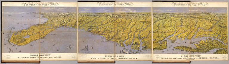
Bachmann, John
Full Title
(Composite of) Panorama of the Seat of War. Birds eye view of Florida and part of Georgia and Alabama .. North and South Carolina and part of Georgia .. Virginia, Maryland, Delaware and the District of Columbia. John Bachmann, Publisher, 115 & 117 Nassau St., New York. Entered ... 1861 by John Bachmann ... New York. Drawn from Nature and Lith. by John Bachmann.
List No
5491.000
Note
Composite map image from three separate issues.
Author
Abbot, Henry L.
Full Title
Campaign Maps, Army Of The Potomac. Map No. 1 Yorktown To Williamsburg. Prepared By Command Of Maj. Gen. George B. McClellan U.S.A. Commanding Army Of The Potomac Brig. Gen. A.A. Humphreys ... Compilation under the Direction of Brig. Gen. A.A. Humphreys, By Capt. H.L. Abbot, Top. Engrs. Engraved by W.H. Dougal.
List No
3879.000
Note
The first in a series of three (see our #3877 and 3878). Shows the entire peninsula south to Fortress Monroe. Indicates confederate defenses at Yorktown. Date is estimated. Plate 18:2 in "Atlas to Accompany..." Map is without color.
Author
Colton, J. H.
Full Title
Colton's New Topographical Map Of The Eastern Portion Of The State Of North Carolina With Part Of Virginia & South Carolina From The Latest & Best Authorities. Published by J.H. Colton, No. 172 William St. N.Y. 1863. Entered ... 1860 by J.H. Colton ... New York. Printed by Lang & Cooper, 117 Fulton St. N.Y. (inset) Plan Of The Sea Coast From Virginia To Florida.
List No
3044.000
Note
1st issued 1861. Last issue 1864. With an inset "Plan of the Sea Coast From Virginia to Florida." This map is a companion map to Colton's Topographical Map of the Seat of War in Virginia, Maryland, &c. (see our copy), but on a larger scale (8 miles to an inch vs. 12 miles). It is both highly detailed (railroads, physical features, towns, counties, etc.) and highly decorative (many ships illustrated off the coasts). Map has outline color by state and water painted in blue; inset has full color by state.
Author
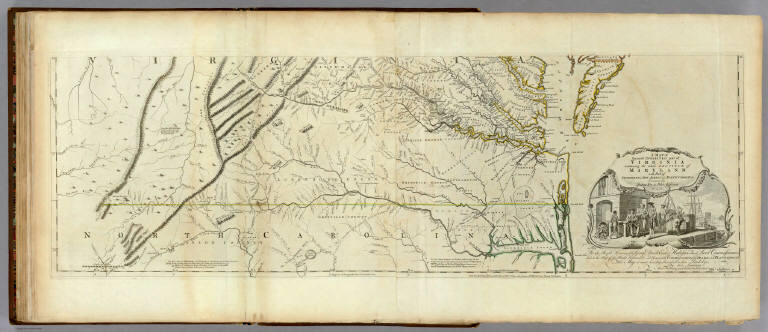
[Jefferys, Thomas, Fry, Joshua, 1700 (ca.)-1754, Jefferson, Peter, 1708-1754]
Full Title
A Map of the most Inhabited part of Virginia containing the whole province of Maryland with Part of Pensilvania, New Jersey and North Carolina. Drawn by Joshua Fry & Peter Jefferson in 1775. Printed for Robt. Sayer ... London. (Southern Section)
List No
0346.024
Note
Southern section in outline color and containing title cartouche. Note below cartouche states: "To the Right Honourable, George Dunk Earl of Halifax First Lord Commissioner; and to the Rest of the Right Honourable and Honourable Commissioners, for Trade and Plantations. This Map is most humbly Inscribed to their Lordships, By their Lordship's Most Obedient & most devoted humble Servt. Thos. Jefferys." Survey lines are noted and explained. In outline color by state.
Author
Semple, E.A.
Full Title
A Plan Of The Property Of The Hampton Normal And Agricultural Institute At Hampton Virginia. Surveyed by E.A. Semple, C.S. American Photo-Lithographic Company, N.Y. (Osborne's Process). S.C.A. Del. Mih. 1876.
List No
5307.000
Note
The Hampton Institute was one of the first black educational institutions in the United States. Outline color.
Author
Lange, Henry, 1821-1893.
Full Title
Der Bundesdistrict Columbia, Virginien, Nord-Carolina, Maryland, u. Delaware. (with inset map) Der Bundesdistrict Columbia. H. Lange's Atlas v. Nord Amerika Blatt IV. Braunschweig: Verlag v. George Westermann. Lith. Anst. von L. Kraatz in Berlin.
List No
2743.004
Note
Engraved map. Borders hand col. Shows roads, canals, railroads, etc. Relief shown by hachures. Scale of inset map (ca. 1:370,000)
Author
[Abbot, Henry L., Cram, Thomas J., United States. War Department]
Full Title
Copy of a map. Sheet no. 1 military reconnaissance, Department of Virginia, Major-General Wool commanding. Drawn by Sergt. Ch. Worret and compiled under the direction of Col. T.J. Cram, Chief Top. Engrs., Dept. Va. (with) Campaign maps, Army of the Potomac. Map no. 1 Yorktown to Williamsburg. Prepared by command of Maj. Gen. George B. McClellan ..., Brig. Gen. A. A. Humphreys ... Map compilation under the direction of Brig. Gen. A.A. Humphreys, by Capt. H.L. Abbot, Top. Engrs., September 1862. Julius Bien & Co., Lith., N.Y. (1891-1895)
List No
1780.018
Note
Col. map with ancillary map. Relief shown by hachures.
1-7 of 7
|