Author
Hopkins, Griffith Morgan
Full Title
Part of ward 10, (city of Providence). Vol. 3, plate P. Entered according to act of Congress in the year 1875 by G.M. Hopkins, in the office of the Librarian of Congress at Washington, D.C.
List No
0327.072
Note
Hand colored lithographed map with inset Shows businesses, fire hydrants, horse car lines, steam car lines, brick or stone buildings, frame buildings, lot numbers, street numbers, landowners, etc. Includes Swan Point Cemetery and East Avenue Plat.
Author
Hopkins, Griffith Morgan
Full Title
Part of ward 10, city of Providence. Vol. 3, plate Q. Entered according to act of Congress in the year 1875 by G.M. Hopkins, in the office of the Librarian of Congress at Washington, D.C.
List No
0327.073
Note
Hand colored lithographed map. Shows businesses, fire hydrants, horse car lines, steam car lines, brick or stone buildings, frame buildings, lot numbers, street numbers, landowners, etc. Includes Blackstone Canal, North Burial Ground, Batcheller Plat and Hedley Plat.
Author
Hopkins, Griffith Morgan
Full Title
Part of ward 10, city of Providence. Vol. 3, plate R. Entered according to act of Congress in the year 1875 by G.M. Hopkins, in the office of the Librarian of Congress at Washington, D.C.
List No
0327.074
Note
Hand colored lithographed map. Shows businesses, fire hydrants, horse car lines, steam car lines, brick or stone buildings, frame buildings, lot numbers, street numbers, landowners, etc. Includes Whipple's Pond, Wanskuck Pond, Geneva Mills, Wanskuck Mills and Roger Williams Chapel.
Author
Hopkins, Griffith Morgan
Full Title
Part of ward 10, city of Providence. Vol. 3, plate S. Entered according to act of Congress in the year 1875 by G.M. Hopkins, in the office of the Librarian of Congress at Washington, D.C.
List No
0327.075
Note
Hand colored lithographed map. Shows businesses, fire hydrants, horse car lines, steam car lines, brick or stone buildings, frame buildings, lot numbers, street numbers, landowners, etc. Includes Hillwood.
Author
Hopkins, Griffith Morgan
Full Title
Part of ward 10, (city of Providence). Vol. 3, plate T. Entered according to act of Congress in the year 1875 by G.M. Hopkins, in the office of the Librarian of Congress at Washington, D.C.
List No
0327.076
Note
Hand colored lithographed map. Shows businesses, fire hydrants, horse car lines, steam car lines, brick or stone buildings, frame buildings, lot numbers, street numbers, landowners, etc.
Author
Hopkins, Griffith Morgan
Full Title
Part of ward 10, (city of Providence). Vol. 3, plate U. Entered according to act of Congress in the year 1875 by G.M. Hopkins, in the office of the Librarian of Congress at Washington, D.C.
List No
0327.077
Note
Hand colored lithographed map. Shows businesses, fire hydrants, horse car lines, steam car lines, brick or stone buildings, frame buildings, lot numbers, street numbers, landowners, etc. Includes Oaklands, and Smith Plat.
Author
Hopkins, Griffith Morgan
Full Title
Part of ward 10, city of Providence. Vol. 3, plate V. Entered according to act of Congress in the year 1875 by G.M. Hopkins, in the office of the Librarian of Congress at Washington, D.C.
List No
0327.078
Note
Hand colored lithographed map. Shows businesses, fire hydrants, horse car lines, steam car lines, brick or stone buildings, frame buildings, lot numbers, street numbers, landowners, etc. Includes Merino Pond and Manton Pond.
Author
Hopkins, Griffith Morgan
Full Title
Part of ward 10, city of Providence. Vol. 3, plate W. Entered according to act of Congress in the year 1875 by G.M. Hopkins, in the office of the Librarian of Congress at Washington, D.C.
List No
0327.079
Note
Hand colored lithographed map. Shows businesses, fire hydrants, horse car lines, steam car lines, brick or stone buildings, frame buildings, lot numbers, street numbers, landowners, etc. Includes part of Merino Pond and Dyerville Manufacturing Co.
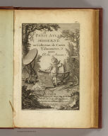
Author
[Delamarche, Charles Francois, Lattre, Jean]
Full Title
(Covers to) Petit atlas moderne ou collection de cartes elementaires dedie a la jeunesse. A Paris, chez Delamarche, Geogr., Rue du Jardinet No. 13, vis a vis celle de l'Eperon. (ca. 1800)
List No
0421A
Note
Modern brown cloth binding with gilt on leather spine title.
Author
[Delamarche, Charles Francois, Lattre, Jean]
Full Title
(Title Page to) Petit atlas moderne ou collection de cartes elementaires dedie a la jeunesse. A Paris, chez Delamarche, Geogr., Rue du Jardinet No. 13, vis a vis celle de l'Eperon. (ca. 1800)
List No
0421B
Note
Engraved illustrated title page showing cherub with globe, maps, surveying instruments, etc. Called "Frontispice" in table of contents.
Author
[Delamarche, Charles Francois, Lattre, Jean]
Full Title
(Contents Page to) Petit atlas moderne ou collection de cartes elementaires dedie a la jeunesse. A Paris, chez Delamarche, Geogr., Rue du Jardinet No. 13, vis a vis celle de l'Eperon. (ca. 1800)
List No
0421C
Note
"Table."
Author
[Delamarche, Charles Francois, Lattre, Jean]
Full Title
(Positions de la Sphere. A Paris, chez Delamarche, Geogr., ca. 1800)
List No
0421.001
Note
Nine engraved maps or illustrations on 1 sheet. Title from table of contents. Contents: Disque de la Lune -- L'Hemisphere de la Terre eclaire par le Soleil au solstice d'Ete -- L'Hemisphere de la Terre eclaire par le Soleil au solstice d'Hyver -- Disque du Soleil -- Eclipse de Soleil -- Horison droit -- Horison parallele -- Eclipse de Lune -- Horison oblique.
Author
[Delamarche, Charles Francois, Lattre, Jean]
Full Title
(Systemes. A Paris, chez Delamarche, Geogr., ca. 1800)
List No
0421.002
Note
Five engraved maps or illustrations on 1 sheet. Title from table of contents. Contents: Sphere armillaire -- Systeme de Ptolomee -- Systeme de Copernic -- Systeme de Ticho-Brahe -- Rose de boussole. Includes notes.
Full Title
Mappe-monde ou description du Globe Terrestre avec les nouvelles decouvertes. P.J. Picquet, sculpt. (A Paris, chez Delamarche, Geogr., ca. 1800)
List No
0421.003
Note
Engraved double hemisphere map. Outline hand coloring. Prime meridian: Ferro. "1."
Full Title
L'Europe suivant ses nouvelles divisions. (A Paris, chez Delamarche, Geogr., ca. 1800)
List No
0421.004
Note
Engraved map. Outline hand coloring. Relief shown pictorially. Prime meridians: Ferro and Paris. "2."
Author
Lattre, Jean
Full Title
Carte de la France divisee par gouvernements. A Paris, chez Lattre, Rue St. Jacques, avec priv. (ca. 1800)
List No
0421.005
Note
Engraved map. Outline hand coloring. Relief shown pictorially. Prime meridian: Ferro.
Full Title
L'Empire Francais, divise en 110 departemens avec les principaux chefs lieux. Picquet sculpt. (A Paris, chez Delamarche, Geogr., ca. 1800)
List No
0421.006
Note
Engraved map. Outline hand coloring. Relief shown pictorially. Prime meridians: Ferro and Paris. "7."
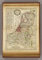
Author
Lattre, Jean
Full Title
Les Pays Bas Septentrionaux et Meridionaux. A Paris, chez Lattre, avec priv. (ca. 1800)
List No
0421.007
Note
Engraved map. Outline hand coloring. Relief shown pictorially. Prime meridian: Ferro.
Full Title
Roymes. d'Espagne et de Portugal divises par gdes. provinces. (A Paris, chez Delamarche, Geogr., ca. 1800)
List No
0421.008
Note
Engraved map. Outline hand coloring. Relief shown pictorially. Prime meridian: Ferro.
Full Title
L'Italie divisee en ses differents etats. Avec priv. (A Paris, chez Delamarche, Geogr., ca. 1800)
List No
0421.009
Note
Engraved map. Outline hand coloring. Relief shown pictorially. Prime meridian: Ferro.
Author
Lattre, Jean
Full Title
L'Allemagne, divisee par cercles avec les etats de Boheme. A Paris, ches Lattre, rue St. Jacq. (ca. 1800)
List No
0421.010
Note
Engraved map. Outline hand coloring. Relief shown pictorially. Prime meridian: Ferro.
Full Title
Royaume de Hongrie divise en ses principales provinces. (A Paris, chez Delamarche, Geogr., ca. 1800)
List No
0421.011
Note
Engraved map. Outline hand coloring. Relief shown pictorially. Prime meridian: Ferro.
Full Title
La Pologne avec ses demenbremens. (A Paris, chez Delamarche, Geogr., ca. 1800)
List No
0421.012
Note
Engraved map. Outline hand coloring. Relief shown pictorially. Prime meridians: Ferro and Paris.
Full Title
Les royaumes d'Angleterre, d'Ecosse et d'Irelande. Avec privil. (A Paris, chez Delamarche, Geogr., ca. 1800)
List No
0421.013
Note
Engraved map. Outline hand coloring. Relief shown pictorially. Includes inset of the Shetland and Orkney islands. Prime meridian: Ferro.
Full Title
Couronnes du Nord comprenant les royaumes de Danemarc, Suede et Norwege. Avec priv. (A Paris, chez Delamarche, Geogr., ca. 1800)
List No
0421.014
Note
Engraved map. Outline hand coloring. Relief shown pictorially. Prime meridian: Ferro.
Author
Delamarche, Charles Francois
Full Title
Russie d'Europe divisee par gouvernemens. A Paris, chez Delamarche, Geogr., rue du Foin St. Jacques. (ca. 1800)
List No
0421.015
Note
Engraved map. Outline hand coloring. Relief shown pictorially. Prime meridian: Ferro.
Full Title
Turquie d'Europe et partie de celle d'Asie, divisee par gds. gouvernemts. (A Paris, chez Delamarche, Geogr., ca. 1800)
List No
0421.016
Note
Engraved map. Outline hand coloring. Relief shown pictorially. Prime meridian: Ferro.
Full Title
L'Asie divisee en ses principaux etats. Avec pivilege du Roi 1783. (A Paris, chez Delamarche, Geogr., ca. 1800)
List No
0421.017
Note
Engraved map. Outline hand coloring. Relief shown pictorially. Prime meridian: Ferro.
Author
Lattre, Jean
Full Title
Les Indes Orientales et leur archipel. A Paris, ches Lattre. Avec priv. (ca. 1800)
List No
0421.018
Note
Engraved map. Outline hand coloring. Relief shown pictorially. Prime meridian: Ferro.
Author
Lattre, Jean
Full Title
L'Empire de la Chine avec les isles du Japon. A Paris, ches Lattre, rue St. Jacq. (ca. 1800)
List No
0421.019
Note
Engraved map. Outline hand coloring. Relief shown pictorially. Prime meridian: Ferro.
Author
Delamarche, Charles Francois
Full Title
L'Afrique divisee en ses principaux etats. A Paris, chez Delamarche, Geo. (ca. 1800)
List No
0421.020
Note
Engraved map. Outline hand coloring. Relief shown pictorially. Prime meridian: Ferro.
Author
Delamarche, Charles Francois
Full Title
L'Egypte ancienne et moderne. A Paris, chez Delamarche, Geog. (ca. 1800)
List No
0421.021
Note
Engraved map. Outline hand coloring. Relief shown pictorially and by hachures. Prime meridian: Ferro.
Full Title
Cotes de Barbarie ou les royaumes de Maroc, de Fez, d'Alger, de Tunis et de Tripoli. Avec privilege. (A Paris, chez Delamarche, Geogr., ca. 1800)
List No
0421.022
Note
Engraved map. Outline hand coloring. Relief shown pictorially. Prime meridian: Ferro.
Author
Delamarche, Charles Francois
Full Title
Amerique Septentrionle. divisee en ses principaux etats. A Paris, chez Delamarche, Geo., 1783. (ca. 1800)
List No
0421.023
Note
Engraved map. Outline hand coloring. Relief shown pictorially. Prime meridian: Ferro.
Full Title
Etats-Unis de l'Amerique Seple. avec le Canada et la Floride. (A Paris, chez Delamarche, Geogr., ca. 1800)
List No
0421.024
Note
Engraved map. Outline hand coloring. Relief shown pictorially. Prime meridian: Ferro.
Author
Delamarche, Charles Francois
Full Title
Golfe du Mexique avec les Isles Antilles. A Paris, chez Delamarche, Geog., avec privil., 1783. (ca. 1800)
List No
0421.025
Note
Engraved map. Outline hand coloring. Prime meridian: Ferro.
Author
Delamarche, Charles Francois
Full Title
Amerique Meridionale divisee en ses principaux etats, avec privilege. A Paris, ches Delamarche, Geo., Rue du Foin St. Jacques. (ca. 1800)
List No
0421.026
Note
Engraved map. Outline hand coloring. Relief shown pictorially. Prime meridian: Ferro.
Author
Delamarche, Charles Francois
Full Title
Carte des 12 tribus d'Israel. A Paris, chez Delamarche, Geog., avec priv. (ca. 1800)
List No
0421.027
Note
Engraved map. Outline hand coloring. Relief shown pictorially. Prime meridian: Ferro.
Author
Delamarche, Charles Francois
Full Title
Carte des regions et des lieux dont il est parle dans le Nouveau Testament. (with) Plan de Jerusalem du tems le N.S.J.Ch. (with) Judee sous Herode le Grand et sous ses 3 fils Archelaus, Herode Antipas et Philippe. A Paris, chez Delamarche, Geogr., ca. 1800)
List No
0421.028
Note
Engraved map with 2 insets. Outline hand coloring. Prime meridian: Ferro.
Full Title
(Covers to) Modern atlas, adapted to Morse's School geography. Boston: Published by Richardson & Lord. Sold also by Collins & Hannay, New-York; and by booksellers generally throughout the country. 1828.
List No
0627A
Note
Accompanies New system of geography. Later edition of the 1824 work. Has outline maps added, plus many changes on the political maps. In outline color and bound with blue cardboard, the title as above. List of "Morse's geographical works" with blurbs on back cover.
Full Title
(Index to) Modern atlas, adapted to Morse's School geography. Boston: Published by Richardson & Lord. Sold also by Collins & Hannay, New-York; and by booksellers generally throughout the country. 1828.
List No
0627B
Note
Inside front cover. "Index to the outlines" is key to features abbreviated on the outline maps.
Author
[Morse, Jedidiah, Morse, Sidney E. (Sidney Edwards), 1794-1871]
Full Title
(Index to) Modern atlas, adapted to Morse's School geography. Boston: Published by Richardson & Lord. Sold also by Collins & Hannay, New-York; and by booksellers generally throughout the country. 1828.
List No
0627C
Note
Inside back cover. "Index to the outlines continued from the first page of the atlas" is key to features abbreviated on the outline maps.
Full Title
The World. J.W. Barber sc. (with) A view of the comparative lengths of the principal rivers ... (with) Table of the comparative heights of the principal mountains in the world. (Published by Richardson & Lord. Sold also by Collins & Hannay, New-York, 1828)
List No
0627.001
Note
Engraved double hemisphere map with diagrams and view. Hand colored.
Full Title
North America. J.W. Barber sc. (Published by Richardson & Lord. Sold also by Collins & Hannay, New-York, 1828)
List No
0627.002
Note
Engraved map. Outline hand colored. Relief shown by hachures.
Full Title
South America. J.W. Barber sc. (with) British Isles. (Published by Richardson & Lord. Sold also by Collins & Hannay, New-York, 1828)
List No
0627.003
Note
Engraved map with inset. Hand colored. Relief shown by hachures.
Full Title
United States. Engraved for Morse's School geography. (Published by Richardson & Lord. Sold also by Collins & Hannay, New-York, 1828)
List No
0627.004
Note
Engraved map. Outline hand colored. Relief shown by hachures. Shows states, settlements, rivers, etc. Prime meridians: Washington and Greenwich. Engraver name erased from plate.
Full Title
Europe. Engraved for Morse's School geography. (Published by Richardson & Lord. Sold also by Collins & Hannay, New-York, 1828)
List No
0627.005
Note
Engraved map. Hand colored. Relief shown by hachures.
Full Title
Asia. J.W. Barber sc. (with) Syria. (Published by Richardson & Lord. Sold also by Collins & Hannay, New-York, 1828)
List No
0627.006
Note
Engraved map. Hand colored. Relief shown by hachures.
Full Title
Africa. J.W. Barber sc. (with) Outline of British Isles. (with) Outline of Europe. (Published by Richardson & Lord. Sold also by Collins & Hannay, New-York, 1828)
List No
0627.007
Note
Engraved map with 2 inset outline maps. Hand colored. Relief shown by hachures.
Full Title
Outline of Asia. Outline of S. America. Outline of Africa. Outline of the U. States. Outline of N. America. (Published by Richardson & Lord. Sold also by Collins & Hannay, New-York, 1828)
List No
0627.008
Note
Five engraved outline maps. Hand colored.
Author
Smith, Asa
Full Title
(Covers to) Smith's illustrated astronomy, designed for the use of the public or common schools in the United States. Illustrated with numerous original diagrams. By Asa Smith, Principal of Public School No. 12, City of New York. Fifth edition. New York: Cady & Burgess, 60 John Street. 1850.
List No
0903A
Note
Tan covers with cloth spine. Includes illustration of "The 2nd telescope in size in the United States at the Cincinnati Observatory" that also appears opposite title page. Ornamental border.
Author
Smith, Asa
Full Title
(Title Page to) Smith's illustrated astronomy, designed for the use of the public or common schools in the United States. Illustrated with numerous original diagrams. By Asa Smith, Principal of Public School No. 12, City of New York. Fifth edition. New York: Cady & Burgess, 60 John Street. 1850.
List No
0903B
Author
Smith, Asa
Full Title
(Contents to) Smith's illustrated astronomy. Entered ... 1848 by Asa Smith ... Southern District of New York. Vincent L. Dill, Stereotyper, Sun Building. C.A. Alvord, Printer. (1850)
List No
0903C
Note
Table of contents.
Author
Smith, Asa
Full Title
(Preface to) Smith's illustrated astronomy. (By Asa Smith. New York: Cady & Burgess, 60 John Street. 1850)
List No
0903D
Full Title
The largest telescopes in the World. Hints to teachers. (By Asa Smith. New York: Cady & Burgess, 60 John Street. 1850)
List No
0903.001
Note
Black and white illustration of telescope at Cincinnati, Ohio, with table of World's largest telescopes and text.
Full Title
(Orrery, with a view of the Solar System in the back ground. By Asa Smith. New York: Cady & Burgess, 60 John Street. 1850)
List No
0903.002
Note
Black and white illustration. Title from table of contents.
Full Title
Saturn. (By Asa Smith. New York: Cady & Burgess, 60 John Street. 1850)
List No
0903.011
Note
Black and white illustration. Insets: Perpendicular view of Saturn's rings -- Saturn (deity) -- A view of Saturn's rings and moons as seen from the planet at midnight.
Full Title
Herschel or Uranus & Leverrier or Neptune. (By Asa Smith. New York: Cady & Burgess, 60 John Street. 1850)
List No
0903.012
Note
Black and white illustration with insets showing two astronomers.
Full Title
Phases of the Moon. (By Asa Smith. New York: Cady & Burgess, 60 John Street. 1850)
List No
0903.013
Note
Black and white illustrations.
Full Title
Telescopic view of the new Moon. (By Asa Smith. New York: Cady & Burgess, 60 John Street. 1850)
List No
0903.014
Note
Black and white illustration.
Full Title
Telescopic view of the full Moon. Telescopic view of the Moon past the last quadrature. (By Asa Smith. New York: Cady & Burgess, 60 John Street. 1850)
List No
0903.015
Note
Two black and white illustrations on 1 sheet.
Full Title
(Eclipses. By Asa Smith. New York: Cady & Burgess, 60 John Street. 1850)
List No
0903.016
Note
Nine (fig. 1-9) black and white illustrations. Title from table of contents.
Full Title
Moons nodes, eclipses, &c. (with) Inferior & superior conjunction, superior & inferior planets. (with) Heleocentric and geocentric longitude. (By Asa Smith. New York: Cady & Burgess, 60 John Street. 1850)
List No
0903.017
Note
Black and white illustration, with 2 insets.
Full Title
Greatest number of eclipses in one year. (By Asa Smith. New York: Cady & Burgess, 60 John Street. 1850)
List No
0903.018
Note
Black and white illustration.
Full Title
Tides. (By Asa Smith. New York: Cady & Burgess, 60 John Street. 1850)
List No
0903.019
Note
Black and white illustration with inset.
Full Title
Orbits of the planets. (By Asa Smith. New York: Cady & Burgess, 60 John Street. 1850)
List No
0903.020
Note
Black and white illustration.
Full Title
Refraction, parallax, light & heat. (By Asa Smith. New York: Cady & Burgess, 60 John Street. 1850)
List No
0903.021
Note
Black and white illustration.
Full Title
Terrestrial & celestial globes. (By Asa Smith. New York: Cady & Burgess, 60 John Street. 1850)
List No
0903.022
Note
Black and white map.
Full Title
Binary or double stars. (By Asa Smith. New York: Cady & Burgess, 60 John Street. 1850)
List No
0903.023
Note
Black and white illustrations.
Full Title
Nebulae or clusters of stars at an immense distance beyond our cluster. (By Asa Smith. New York: Cady & Burgess, 60 John Street. 1850)
List No
0903.024
Note
Black and white illustrations. Contents: Resolved nebulae -- Stellar and resolvable nebulae -- Double nebulae -- Hollow nebulae -- I(r)resolvable and planetary nebulae -- Remarkable nebulae -- elongated nebulae.
Full Title
Visible heavens from January 21st to April 17th. (By Asa Smith. New York: Cady & Burgess, 60 John Street. 1850)
List No
0903.025
Note
Black and white map.
Full Title
Visible heavens from April 18th to July 21st. (By Asa Smith. New York: Cady & Burgess, 60 John Street. 1850)
List No
0903.026
Note
Black and white map.
Full Title
Visible heavens from July 22nd to October 31st. (By Asa Smith. New York: Cady & Burgess, 60 John Street. 1850)
List No
0903.027
Note
Black and white map.
Full Title
Visible heavens from November 1st to Jany. 20th. (By Asa Smith. New York: Cady & Burgess, 60 John Street. 1850)
List No
0903.028
Note
Black and white map.
Author
Thomson, John
Full Title
(Covers to) A new general atlas, consisting of a series of geographical designs, on various projections, exhibiting the form and component parts of the globe; and a collection of maps and charts, delineating the natural and political divisions of the empires, kingdoms, and states in the World. Constructed from the best systematic works, and the most authentic voyages and travels. With a memoir of the progress of geography, a summary of physical geography, and a consulting index to facilitate the finding out of places. Edinburgh: Printed by George Ramsay and Company, for John Thomson and Company, Edinburgh; Baldwin, Cradock, and Joy, London; and John Cumming, Dublin. 1817.
List No
1007A
Author
Thomson, John
Full Title
(Title Page to) A new general atlas, consisting of a series of geographical designs, on various projections, exhibiting the form and component parts of the globe; and a collection of maps and charts, delineating the natural and political divisions of the empires, kingdoms, and states in the World. Constructed from the best systematic works, and the most authentic voyages and travels. With a memoir of the progress of geography, a summary of physical geography, and a consulting index to facilitate the finding out of places. Edinburgh: Printed by George Ramsay and Company, for John Thomson and Company, Edinburgh; Baldwin, Cradock, and Joy, London; and John Cumming, Dublin. 1817.
List No
1007B
Author
Thomson, John
Full Title
(Contents to) A new general atlas, consisting of a series of geographical designs, on various projections, exhibiting the form and component parts of the globe; and a collection of maps and charts, delineating the natural and political divisions of the empires, kingdoms, and states in the World. Constructed from the best systematic works, and the most authentic voyages and travels. With a memoir of the progress of geography, a summary of physical geography, and a consulting index to facilitate the finding out of places. Edinburgh: Printed by George Ramsay and Company, for John Thomson and Company, Edinburgh; Baldwin, Cradock, and Joy, London; and John Cumming, Dublin. 1817.
List No
1007C
Note
Lists contents of major parts of the atlas. Includes dedication by Thompson to Alexander Keith and (Keith's?) coat of arms by "Hewitt sculp., Grafton Str. East."
Author
Thomson, John
Full Title
(Contents to) A new general atlas, consisting of a series of geographical designs, on various projections, exhibiting the form and component parts of the globe; and a collection of maps and charts, delineating the natural and political divisions of the empires, kingdoms, and states in the World. Constructed from the best systematic works, and the most authentic voyages and travels. With a memoir of the progress of geography, a summary of physical geography, and a consulting index to facilitate the finding out of places. Edinburgh: Printed by George Ramsay and Company, for John Thomson and Company, Edinburgh; Baldwin, Cradock, and Joy, London; and John Cumming, Dublin. 1817.
List No
1007D
Note
"List of projections, maps, and charts, arranged to suit the consulting index." "Printed by George Ramsay and Company, Edinburgh, 20th September 1817."
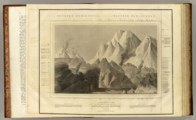
Author
Thomson, John
Full Title
A comparative view of the heights of the principal mountains and other elevations in the World. Drawn & engraved for Thomson's New general atlas by W. & D. Lizars, Edinburgh. (1817)
List No
1007.001
Note
Engraved view. Includes vertical scale with names of heights.
Author
Thomson, John
Full Title
Hydrographical chart of the World on Wright or Mercators projection with tracts of the last circumnavigators. R. Scott sculpt. Drawn and engraved for John Thompson Junr. & Co., Edinburgh, 1814.
List No
1007.002
Note
Engraved map. Outline hand color. Relief shown pictorially.
Author
Thomson, John
Full Title
Northern Hemisphere. Kirkwood sculp. Drawn & engraved for John Thompson Co.'s New general atlas, 12 August 1814.
List No
1007.003
Note
Engraved map. Hand colored. Relief shown pictorially.
Author
Thomson, John
Full Title
Southern Hemisphere. Kirkwood sculp. Drawn & engraved for John Thompson Co.'s New general atlas, 12 August 1814.
List No
1007.004
Note
Engraved map. Hand colored. Relief shown pictorially.
Author
Thomson, John
Full Title
Eastern Hemisphere. Drawn & engraved for Thomson's New general atlas, 1815.
List No
1007.005
Note
Engraved map. Hand colored. Relief shown pictorially.
Author
Thomson, John
Full Title
Western Hemisphere. Drawn & engraved for Thomson's New general atlas, 1815.
List No
1007.006
Note
Engraved map. Hand colored. Relief shown pictorially.
Author
[Buchanan, George, Thomson, John]
Full Title
Northern Hemisphere projected on the plane of the horizon of London. By Geo. Buchanan. J. & G. Menzies sculpt., Edinr. Projected & engraved for Thomson's New general atlas, 20th Sept. 1816.
List No
1007.007
Note
Engraved map. Outline hand color. Relief shown by hachures. "N.B. The scale is quite correct for distances from London; it is also very nearly so for distances on any part of the meridian of London or on any lines passing through London."
Author
[Buchanan, George, Thomson, John]
Full Title
Southern Hemisphere projected on the plane of the horizon of London. By Geo. Buchanan. J. & G. Menzies sculpt., Edinr. Projected & engraved for Thomson's New general atlas, 20th Sept. 1816.
List No
1007.008
Note
Engraved map. Outline hand color. Relief shown by hachures. "N.B. The scale only measures with sufficient accuracy distances in the direction of the meridians."
Author
Thomson, John
Full Title
Europe. J. & G. Menzies sculpt. (1817)
List No
1007.009
Note
Engraved map. Hand color. Relief shown pictorially.
Author
Thomson, John
Full Title
British Isles. Drawn & engraved by Hewitt, Broad Str., Bloomsby. Drawn & engraved for Thomson's New general atlas, May 1st, 1815.
List No
1007.010
Note
Engraved map. Hand colored. Relief shown by hachures. Includes inset of Orkney and Shetland islands.
Author
Thomson, John
Full Title
Ireland. Neale (i.e. Neele) sculpt., Strand, London. Drawn & engraved for Thomson's New general atlas Feby. 1815.
List No
1007.011
Note
Engraved map. Hand colored. Relief shown by hachures.
Author
Thomson, John
Full Title
Scotland. Drawn & engraved by Hewitt, Broad Str(ee)t., Bloomsbury. Drawn and engraved for Thomson's New general atlas. April 1st, 1815.
List No
1007.012
Note
Engraved map. Hand colored. Relief shown by hachures. Includes inset of the Shetland and Orkney islands.
Author
Thomson, John
Full Title
England. Neele sculpt., Strand, London. Drawn & engraved for Thomson's New general atlas, Septr. 16, 1814.
List No
1007.013
Note
Engraved map. Hand colored. Relief shown by hachures. Shows ship routes, roads, settlements, counties, etc.
Author
Thomson, John
Full Title
Remote British islands. Drawn & engraved by N.R. Hewitt, Grafton Strt., East Tottenham Court Road. Drawn & engraved for Thomson's New general atlas. Jany. 1st, 1817.
List No
1007.014
Note
Five engraved maps and 2 views. Outline hand color. Relief shown by hachures. Contents: Isles of Guernsey, Herm, Sark and Alderney. Scale 1:250,000 -- Isle of Jersey. Scale 1:150,000 -- Isles of Scilly. Scale 1:120,000 -- Isle of Mann. Scale 1:180,000 -- Isle of Wight. Scale 1:160,000 -- View of Eddystone Light House -- Freshwater Bay, in the Isle of Wight, with a distant view of the Needle Rocks.
Author
Thomson, John
Full Title
The British Channel. J. & G. Menzies sculpt., Edinr. Drawn & engraved for Thomson's New general atlas, 16th Sept. 1814.
List No
1007.015
Note
Engraved map. Hand colored.
Author
Thomson, John
Full Title
Chart of the North and Baltic seas, &c. (with) Harbour of Heligoland. (with) Port of Revel. (with) Harbour of St. Petersburg. Neele sc., Strand. Drawn & engraved for Thomson's New general atlas, 1816.
List No
1007.016
Note
Engraved map with 3 ancillary maps. Hand colored. Depths shown by soundings.
Author
Thomson, John
Full Title
Scandinavia, or Sweden, Denmark & Norway. J. & G. Menzies sculpt., Edinbr. (Drawn & engraved for Thomson's New general atlas, 1817)
List No
1007.017
Note
Engraved map. Hand colored.
Author
Thomson, John
Full Title
Denmark. (with) Iceland. (with) Feroe Islands. Engd. by W. Dassauville, Edin. Drawn & engraved for Thomson's New general atlas, 14th July 1814.
List No
1007.018
Note
Engraved map with 2 insets. Hand colored. Relief shown by hachures.
Author
Thomson, John
Full Title
Germany north of the Mayne. Neele sc., Strand, London. Drawn & engraved for Thomson's New general atlas, 1816.
List No
1007.019
Note
Engraved map. Hand colored. Relief shown by hachures.
Author
Thomson, John
Full Title
Holland. Neele sculpt., London. Drawn & engraved for Thomson's New general atlas, 16th Septr. 1814.
List No
1007.020
Note
Engraved map. Hand colored.
Author
Thomson, John
Full Title
Belgium or the Netherlands. Drawn and engraved for Thomson's New general atlas, 1815.
List No
1007.021
Note
Engraved map. Hand colored.
Author
Thomson, John
Full Title
France. Engd. by Kirkwood & Son, Edinr. (Drawn & engraved for Thomson's New general atlas, 1817)
List No
1007.022
Note
Engraved map. Hand colored. Relief shown pictorially.
Author
Thomson, John
Full Title
France, in provinces. Kirkwood sculpt. Drawn & engraved for Thomson's New general atlas, 12 August 1814.
List No
1007.023
Note
Engraved map. Hand colored. Relief shown by hachures.
Author
Thomson, John
Full Title
Spain & Portugal. J. & G. Menzies sculpt., Edinr. Drawn & engraved for Thomson's New general atlas, 21st Augt. 1815.
List No
1007.024
Note
Engraved map. Hand colored. Relief shown by hachures.
Author
Thomson, John
Full Title
Chart of the Mediterranean Sea. (with) Bay & roads of Marseilles. (with) The harbour of Genoa. (with) Plan of the rock and bay of Gibraltar shewing the position of the combined fleet and attack of the battering ships in 1782. (with) Leghorn Road. (with) Sketch of the watering place of Algeziras. (with) Attack on Algiers by the fleet under the command of Adml. Lord Exmouth, Augst. 27th 1816. (with) Gulf of Smyrna. Neele sculp., Strand. Drawn & engraved for Thomson's New general atlas, 1817.
List No
1007.025
Note
Engraved map with 7 inset maps. Outline hand color. Relief shown by hachures; depths by soundings in insets.
Author
Thomson, John
Full Title
Attica. Turkish dominions in Europe. E. Mitchell sculpt. Drawn and engraved for Thomson's New general atlas, 1815.
List No
1007.026
Note
Two engraved maps on 1 sheet. Hand colored. Relief shown by hachures.
Author
Thomson, John
Full Title
Italy. (with) Island of Elba. R. Scott, sculpt. Drawn & engraved for Thomson's New general atlas, 1814.
List No
1007.027
Note
Engraved map with inset. Outline hand color. Relief shown by hachures.
Author
Thomson, John
Full Title
Venetian States. Drawn & engraved by N.R. Hewitt, Charlotte Str(ee)t, Fitzroy Square. Drawn and engraved for Thomson's New general atlas, 1816.
List No
1007.028
Note
Engraved map. Hand colored.
Author
Thomson, John
Full Title
Swisserland (with view) Mont Blanc, nearly three miles above the level of the sea. T. Clerk sculpt. Drawn & engraved for Thomson's New general atlas, 1814.
List No
1007.029
Note
Engraved map. Hand colored. Relief shown by hachures and pictorially. With b&w view.
Author
Thomson, John
Full Title
Germany south of the Mayne. Neele sc., London. Drawn & engraved for Thomson's New general atlas, 1816.
List No
1007.030
Note
Engraved map. Hand colored. Relief shown by hachures. Includes Vorarlberg and the Archbishopric of Salzburg.
Author
Thomson, John
Full Title
Austrian Dominions. Neele, sculp., 352, Strand. Drawn & engraved for Thomson's New general atlas, 1816.
List No
1007.031
Note
Engraved map. Hand colored. Relief shown by hachures.
Author
Thomson, John
Full Title
Prussian Dominions. Engd. by W. Dassauville. (Drawn & engraved for Thomson's New general atlas, 1817)
List No
1007.032
Note
Engraved map. Hand colored. Relief shown by hachures.
Author
Thomson, John
Full Title
Poland as divided. J. & G. Menzies sculpt, Edinr. (Drawn & engraved for Thomson's New general atlas, 1817)
List No
1007.033
Note
Engraved map. Hand colored. Relief shown by hachures.
Author
Thomson, John
Full Title
European Russia. Engd. by J. Moffat, Edinr. Drawn and engraved for Thomson's New general atlas, July 21, 1815.
List No
1007.034
Note
Engraved map. Hand colored. Relief shown by hachures.
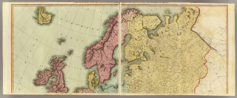
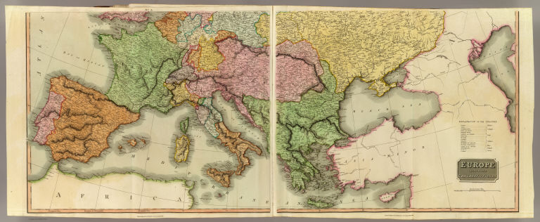
Author
Thomson, John
Full Title
A map of Europe with the political divisions after the Peace of Paris and Congress of Vienna. Drawn & engraved for Thomson's New general atlas, 1816.
List No
1007.035
Note
Two engraved maps. Hand colored. Sheets 1 and 2 (or the northern half) of "Europe after the Congress of Vienna" engraved by Neele. Relief shown by hachures.
Author
Thomson, John
Full Title
Europe after the Congress of Vienna. Neele sculpt., 352 Strand, London. Drawn & engraved for Thomson's New general atlas, 1816.
List No
1007.036
Note
Two engraved maps. Hand colored. Sheets 3 and 4 (or the southern half). Sheets 1-2 have title in upper margins: A map of Europe with the political divisions after the Peace of Paris and Congress of Vienna. Relief shown by hachures.
Author
Thomson, John
Full Title
(Composite of) Europe after the Congress of Vienna. Neele sculpt., 352 Strand, London. Drawn & engraved for Thomson's New general atlas, 1816.
List No
1007.037
Note
Composite of four engraved maps. Hand colored. Sheets 1-2 have title in upper margins: A map of Europe with the political divisions after the Peace of Paris and Congress of Vienna. Relief shown by hachures.
Author
Thomson, John
Full Title
Asia. J. & G. Menzies sculpt. (Drawn & engraved for Thomson's New general atlas, 1817)
List No
1007.038
Note
Engraved map. Hand colored. Relief shown pictorially.
Author
Thomson, John
Full Title
Russian Empire. N.R. Hewitt Sc., 10 Broad Str., Bloomsby., London. Drawn & engraved for John Thomson & Co.'s New general atlas, 12 August 1814.
List No
1007.039
Note
Engraved map. Outline hand color. Relief shown by hachures.
Author
Thomson, John
Full Title
Tartary. N.R. Hewitt sc., 10 Broad Str., Bloomsbry., London. Drawn and engraved for Thomson's New general atlas, Sepr. 1st., 1814.
List No
1007.040
Note
Engraved map. Outline hand color. Relief shown by hachures.
Author
Thomson, John
Full Title
Corea and Japan. J. & G. Menzies sculpt., Edinr. Drawn & engraved for Thomson's New general atlas, 16th. Augt. 1815.
List No
1007.041
Note
Engraved map. Hand colored. Relief shown by hachures.
Author
Thomson, John
Full Title
China. R. Scott sculpt., Edinr. Drawn & engraved for Thomson's New general atlas. Edinburgh 1815.
List No
1007.042
Note
Engraved map. Hand colored. Relief shown by hachures. Shows "Tract of the Hindoostan & Lion with the British Embassy to China 1793."
Author
Thomson, John
Full Title
East India Isles. T. Clerk sculpt., Edinr. (Drawn & engraved for Thomson's New general atlas, 1817)
List No
1007.043
Note
Engraved map. Hand colored. Relief shown pictorially.
Author
[J. & G. Menzies, Thomson, John]
Full Title
Hindoostan. (with) Isle of Ceylon. J. & G. Menzies sculpt., Edinr. (Drawn & engraved for Thomson's New general atlas, 1817)
List No
1007.044
Note
Engraved map with inset. Hand colored. Relief shown by hachures.
Author
Thomson, John
Full Title
Northern Hindostan. (with) Cabul. (with) Napaul. S.J. Neele sculp., 352 Strand. Drawn & engraved for Thomson's New general atlas, 1817.
List No
1007.045
Note
Engraved map with 2 insets. Hand colored. Relief shown by hachures.
Author
Thomson, John
Full Title
Southern Hindostan. Neele sculpt. Drawn & engraved for Thomson's New general atlas, 1816.
List No
1007.046
Note
Engraved map. Hand colored. Relief shown by hachures.
Author
Thomson, John
Full Title
Birman Empire. Engd. by Moffat & Smellie Edinr. Drawn & engraved for Thomson's New general atlas. (1817)
List No
1007.047
Note
Engraved map. Hand colored. Relief shown by hachures. Covers present-day Burma and parts of Bhutan, India, Bangladesh, Thailand, Cambodia, Laos, Vietnam and southern China.
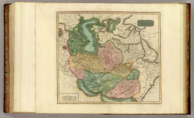
Author
Thomson, John
Full Title
Persia. J. & G. Menzies sculpt., Edinr. (Drawn & engraved for Thomson's New general atlas, 1817)
List No
1007.048
Note
Engraved map. Hand colored. Relief shown by hachures.
Author
Thomson, John
Full Title
Turkey in Asia. Engd. by W. Dassauville. (Drawn & engraved for Thomson's New general atlas, 1817)
List No
1007.049
Note
Engraved map. Hand colored. Relief shown pictorially.
Author
Thomson, John
Full Title
Arabia, Egypt, Abyssinia, Red Sea &c. J. & G. Menzies sculpt., Edinr. Drawn and engraved for Thomson's New general atlas, 14th July 1814.
List No
1007.050
Note
Engraved map. Outline hand color. Relief shown by hachures. Includes descriptive notes.
Author
Thomson, John
Full Title
Africa. Drawn and engraved for Thomson's New general atlas. (1817)
List No
1007.051
Note
Engraved map. Hand colored. Relief shown by hachures. Engraver name and date erased from plate. "No. 47." "47/2" added by hand on verso.
Author
[J. & G. Menzies, Thomson, John]
Full Title
Africa. J. & G. Menzies sculpt. (Drawn & engraved for Thomson's New general atlas, 1813?)
List No
1007.052
Note
Engraved map. Hand colored. Relief shown pictorially. Printed label with "No. 47" pasted on verso.
Author
Thomson, John
Full Title
Egypt. Abyssinia. Engraved by N.R. Hewitt. Drawn & engraved for Thomson's New general atlas, 1817.
List No
1007.053
Note
Two engraved maps on 1 sheet. Hand colored. Relief shown by hachures. Includes descriptive notes.
Author
Thomson, John
Full Title
North Africa. South Africa. Engd. by W. Dassauville, Edinr. Drawn and engraved for Thomson's New general atlas, 1815.
List No
1007.054
Note
Two engraved maps on 1 sheet. Hand colored. Relief shown by hachures. Label with "No. 49" affixed to upper left corner.
Author
Thomson, John
Full Title
Atlantic islands. Cape Verd Ids. Canary Ids. Azore Ids. Madeira Ids. (with) Road of Rayal with Porto Pin in the island of Fayal. (with) Puerto de Naos and Puerto Cavillo in the isle of Lancarota. (with view) The peak of Teneriffe ... T. Clerk sculpt. Drawn & engraved for Thomson's New general atlas, Sepr. 16th, 1814.
List No
1007.055
Note
Four engraved maps on 1 sheet, with 2 inset maps and a view. Hand colored. Relief shown by hachures. Prime meridian: Ferro.
Author
Thomson, John
Full Title
Chart of North Atlantic Ocean with tracks of the shipping to West Indies, North America &ce. Engd. by J. Moffat, Edinr. (Drawn & engraved for Thomson's New general atlas, 1817)
List No
1007.056
Note
Engraved map. Hand colored. Depths shown by soundings. Prime meridians: London and Ferro.
Author
Thomson, John
Full Title
America. J. & G. Menzies sculpt. Drawn and engraved for Thomson's New general atlas, 1st July, 1813.
List No
1007.057
Note
Engraved map. Hand colored. Relief shown pictorially.
Author
Thomson, John
Full Title
North America. N.R. Hewitt sc., 10 Broad Str., Bloomsby., London. Drawn and engraved for Thomson's New general atlas, 1814.
List No
1007.058
Note
Engraved map. Hand colored. Relief shown by hachures. Coloring differs from other copy.
Author
Thomson, John
Full Title
North America. N.R. Hewitt sc., 10 Broad Str., Bloomsby., London. Drawn and engraved for Thomson's New general atlas, 1814.
List No
1007.059
Note
Engraved map. Hand colored. Relief shown by hachures. Unlike other copy, this shows coasts of Hudson's Bay, Labrador and Upper and Lower Canada in yellow, and also has annotations.
Author
Thomson, John
Full Title
Canada and Nova Scotia. Engd. by W. Dassauville, Edinr. (Drawn & engraved for Thomson's New general atlas, 1817)
List No
1007.060
Note
Engraved map. Hand colored. Relief shown by hachures.
Author
Thomson, John
Full Title
United States of America. (with) The course of the River St. Laurence, from Lake Ontario to Manicouagan Point. J. & G. Menzies sculpt., Edinr. (Drawn & engraved for Thomson's New general atlas, 1817)
List No
1007.061
Note
Engraved map with ancillary map. Hand colored. Relief shown by hachures.
Author
Thomson, John
Full Title
Northern provinces of the United States. (with view) The Great Falls of Niagara. Hewitt sc., Grafton Str. E(a)st, Tottenham Ct. Rd. Drawn & engraved for Thomson's New general atlas, 1817.
List No
1007.062
Note
Engraved map. Hand colored. Relief shown by hachures.
Author
Thomson, John
Full Title
Southern provinces of the United States. (with view) Characteristic scenery of the Hudson River. Hewitt sc., Grafton Str. East, Tottenham Court Rd. Drawn & engraved for Thomson's New general atlas, 1817.
List No
1007.063
Note
Engraved map. Hand colored. Relief shown by hachures. Shows settlements, Indian tribes, etc.
Author
Thomson, John
Full Title
Spanish North America. Drawn and engraved for Thomson's New general atlas, 1814.
List No
1007.064
Note
Engraved map. Hand colored. Relief shown by hachures. Shows drainage, state boundaries, Indian tribes, etc.
Author
Thomson, John
Full Title
Spanish North America, southern part. Drawn & engraved for Thomson's New general atlas, 1816.
List No
1007.065
Note
Engraved map. Hand colored. Relief shown by hachures.
Author
Thomson, John
Full Title
West Indies. Engraved by Kirkwood & Son, Edinr. Drawn & engraved for John Thomson & Co.'s New general atlas, 12 August 1814.
List No
1007.066
Note
Engraved map. Hand colored. Relief shown by hachures. Prime meridians: Ferro and London.
Author
Thomson, John
Full Title
Island of Cuba. (with) Chart of the Bahama Islands. (with) The Bermudas or Summer Islands. Neele sculp., Strand. Drawn & engraved for Thomson's New general atlas, 1816.
List No
1007.067
Note
Engraved map with 2 ancillary maps. Hand colored. Relief shown by hachures; Bahamas map also shows depths by soundings.
Author
Thomson, John
Full Title
Jamaica. (with) The harbour of Bluefields. (with) The harbours of Kingston and Port Royal. T. Clerk sculpt. (Drawn & engraved for Thomson's New general atlas, 1817)
List No
1007.068
Note
Engraved map with 2 insets. Hand colored. Relief shown by hachures.
Author
Thomson, John
Full Title
Porto Rico and Virgin Isles. Haiti, Hispaniola or St. Domingo. West India Islands. J. & G. Menzies sculpt., Edinr. Drawn and engraved for Thomson's New general atlas, Feby. 1815.
List No
1007.069
Note
Two engraved maps on 1 sheet. Hand colored. Relief shown by hachures. Scale of Hispaniola map ca. 1:1,150,000.
Author
Thomson, John
Full Title
St. Christophers. (with) St. Lucia. (with) Nevis. West India Islands. Engraved by Kirkwood & Son, Edinburgh. (Drawn & engraved for Thomson's New general atlas, 1817)
List No
1007.070
Note
Engraved map with 2 insets. Hand colored. Relief shown by hachures. Scale of St. Lucia map ca. 1:250,000, Nevis ca. 1:100,000.
Author
Thomson, John
Full Title
Guadaloupe. (with) Mariegalante &c. (with) Antigua. West India Islands. Engraved by Kirkwood & Son, Edinburgh. (Drawn & engraved for Thomson's New general atlas, 1817)
List No
1007.071
Note
Engraved map with 2 insets. Hand colored. Relief shown by hachures. Scales of insets: Marie Galante ca. 1:240,000, Antigua ca. 1:90,000. Prime meridians: London and Ferro.
Author
Thomson, John
Full Title
Martinico. (with) Dominica. (with) Cul de Sac Royal. West India Islands. Engraved by Kirkwood & Son, Edinr. (Drawn & engraved for Thomson's New general atlas, 1817)
List No
1007.072
Note
Engraved map with 2 insets. Hand colored. Relief shown by hachures. Scale of Dominica map ca. 1:137,000.
Author
Thomson, John
Full Title
St. Vincent. Barbadoes. West India Islands. Engraved by Kirkwood & Son, Edinburgh. (Drawn & engraved for Thomson's New general atlas, 1817)
List No
1007.073
Note
Two engraved maps. Hand colored. Relief shown by hachures. Scale of Barbadoes map ca. 1:85,000. Prime meridians: Ferro and London.
Author
Thomson, John
Full Title
Grenada. Tobago. Trinidad. Curacao. (with) Fort Amsterdam. West India Islands. Neele sc., Strand. Drawn & engraved for Thomson's New general atlas, 1816.
List No
1007.074
Note
Four engraved maps with inset. Hand colored. Relief shown by hachures.
Author
Thomson, John
Full Title
South America. Engd. by J. Moffat, Edinr. Drawn and engraved for Thomson's New general atlas, Edinr., Septr. 16th, 1814.
List No
1007.075
Note
Engraved map. Hand colored. Relief shown by hachures.
Author
Thomson, John
Full Title
Caraccas and Guiana. Engd. by J. Moffat, Edinr. (Drawn & engraved for Thomson's New general atlas, 1817)
List No
1007.076
Note
Engraved map. Hand colored. Relief shown by hachures. Covers Venezuela, the Guianas and parts of Colombia, Peru and Brazil. Shows rivers, settlements, Indian tribes, etc.
Author
Thomson, John
Full Title
Peru, Chili and La Plata. Drawn & engraved for Thomson's New general atlas, 1816.
List No
1007.077
Note
Engraved map. Hand colored. Relief shown by hachures. Covers Bolivia, Paraguay, Uruguay and parts of Peru, Chile, Argentina and Brazil.
Author
Thomson, John
Full Title
Map of the islands in the Pacific Ocean. (with) Owhyhee. (with) Karakakooa Bay, Owhyhee. (with) Otaheite. (with) Matavia Bay, Otaheite. Neele sculp., 352 Strand. Drawn & engraved for Thomson's New general atlas, 1817.
List No
1007.078
Note
Engraved map with 4 insets. Hand colored. Relief shown by hachures.
Author
Thomson, John
Full Title
New Holland and Asiatic isles. Drawn and engraved for Thomson's New general atlas, 1814.
List No
1007.079
Note
Engraved map. Hand colored. Relief shown by hachures. David Rumsey Collection copy: has place names added in pencil.
Author
Thomson, John
Full Title
Chart of the Northern Passage between Asia & America. Neele sculp., 352 Strand. Drawn & engraved for Thomson's New general atlas, 1816.
List No
1007.080
Note
Engraved map. Hand colored. Relief shown by hachures; depths by soundings. Shows settlements, Cook's tracks 1778-79.
Author
Thomson, John
Full Title
A chart of New South Wales, Van Diemen's Land. Surveys in the interior of New South Wales. (with) Van Diemen's Land, from the most recent authorities and surveys. (with) Part of Australasia. (with) British settlements at Port Jackson, &c. J. Aspin, del. Hewitt sculp., Buckingham Place. (Drawn & engraved for Thomson's New general atlas, 1821)
List No
1007.081
Note
Engraved map with 3 insets. Hand colored. Relief shown by hachures. An added sheet.
Author
Thomson, John
Full Title
A chart of the discoveries of Captains Ross, Parry & Franklin in the Arctic Regions in the years 1818, 1819, 1820, 1821 & 1822. (with) Capt. Franklin's journey from Coppermine River to the head of Bathurst Inlet & return by Hood's River. J. Aspin delt. Hewitt sc., Buckingham Place. (Drawn & engraved for Thomson's New general atlas) (1822?)
List No
1007.082
Note
Engraved map with inset. Hand colored. David Rumsey Collection copy has the names "Mag. Pole" and "C. Garry" added in pencil. An added sheet.
Author
[Gamble, William H., Miller, M. A. (Matthew Amos), White, M. Wood]
Full Title
(Covers to) White's new county and district atlas of the state of West Virginia. Comprising fifty-four counties; three hundred and twenty-seven township districts; and two thousand five hundred and sixty-seven school districts. From the most recent surveys and authentic sources. Maps drawn by William H. Gamble, Philadelphia, Penna. Examined and corrected by M.A. Miller, top. eng., Staunton, Virginia. Grafton, West Virginia: M. Wood White. Philadelphia: S.A. Mitchell. 1873. Entered ... 1873 by M. Wood White ... at Washington.
List No
1199A
Note
Bound in half leather dark brown cloth covered boards with "White's West Virginia atlas" stamped in gilt.
Author
[Gamble, William H., Miller, M. A. (Matthew Amos), White, M. Wood]
Full Title
(Title Page to) White's new county and district atlas of the state of West Virginia. Comprising fifty-four counties; three hundred and twenty-seven township districts; and two thousand five hundred and sixty-seven school districts. From the most recent surveys and authentic sources. Maps drawn by William H. Gamble, Philadelphia, Penna. Examined and corrected by M.A. Miller, top. eng., Staunton, Virginia. Grafton, West Virginia: M. Wood White. Philadelphia: S.A. Mitchell. 1873. Entered ... 1873 by M. Wood White ... at Washington.
List No
1199B
Note
William H. Gamble did maps; Mitchell collaborated. Bound in half leather dark brown cloth covered boards with "White's West Virginia atlas." stamped in gilt. Full color.
Author
[Gamble, William H., Miller, M. A. (Matthew Amos), White, M. Wood]
Full Title
(Contents Page to) White's new county and district atlas of the state of West Virginia. Comprising fifty-four counties; three hundred and twenty-seven township districts; and two thousand five hundred and sixty-seven school districts. From the most recent surveys and authentic sources. Maps drawn by William H. Gamble, Philadelphia, Penna. Examined and corrected by M.A. Miller, top. eng., Staunton, Virginia. Grafton, West Virginia: M. Wood White. Philadelphia: S.A. Mitchell. 1873. Entered ... 1873 by M. Wood White ... at Washington.
List No
1199C
Author
Mitchell, Samuel Augustus
Full Title
A time table indicating the difference in time between the principal cities of the world, and also showing their air-line distance from Washington. Entered according to Act of Congress in the year 1864 by S. Augustus Mitchell, Jr. in the ... District Court of the U.S. for the Eastern District of Pennsylvania. (1873)
List No
1199.001
Note
Hand colored lithograph.
Author
Mitchell, Samuel Augustus
Full Title
Map of the World on the Mercator projection, exhibiting the American continent as its centre. Entered according to Act of Congress in the year 1872 by S. Augustus Mitchell in the Office of the Librarian of Congress at Washington. (1873)
List No
1199.002
Note
Lithographed map. Hand colored. Relief shown by hachures. Countries in full color. Shows explorers' sea routes.
Author
[Mitchell, Samuel Augustus, Williams, W. (Wellington)]
Full Title
Map of the United States, and territories. Together with Canada &c. (with) Island of Newfoundland. Constructed & engraved by W. Williams, Philadelphia. Entered according to Act of Congress in the year 1872 by S. Augustus Mitchell in the Office of the Librarian of Congress at Washington. (1873)
List No
1199.003
Note
Lithographed map. Hand colored. Relief shown by hachures. States, provinces in full color. Shows settlements, railroads, routes in west, etc. Prime meridians: Greenwich and Washington.
Author
[Gamble, William H., Mitchell, Samuel Augustus]
Full Title
County map of West Virginia. Drawn & eng. by W.H. Gamble, Phila. Entered according to Act of Congress in the year 1872 by S. Augustus Mitchell in the Office of the Librarian of Congress at Washington. (1873)
List No
1199.004
Note
Lithographed map. Hand colored. Relief shown by hachures. Counties in full color. Shows settlements, railroads, etc. Prime meridians: Greenwich and Washington. Ornamental border.
Author
[Gamble, William H., White, M. Wood]
Full Title
White's political map of West Virginia. Drawn & eng. by W.H. Gamble, Phila. Entered according to Act of Congress in the year 1873 by M. Wood White in the Office of the Librarian of Congress at Washington.
List No
1199.005
Note
Lithographed map. Hand colored. Relief shown by hachures. Shows settlements, railroads, congressional and senatorial districts, etc. Prime meridians: Greenwich and Washington. Ornamental border.
Author
[Gamble, William H., Mitchell, Samuel Augustus]
Full Title
Map showing the coal fields of West Virginia. Drawn & eng. by W.H. Gamble, Phila. Entered according to Act of Congress in the year 1872 by S. Augustus Mitchell in the Office of the Librarian of Congress at Washington. (1873)
List No
1199.006
Note
Lithographed map. Hand colored. Relief shown by hachures. Shows also settlements, railroads, etc. Prime meridians: Greenwich and Washington. Ornamental border.
Author
White, M. Wood
Full Title
White's topographical, county & district atlas of West Virginia. Counties of Morgan, Berkeley, Jefferson. (with) Charlestown. (with) Martinsburg. Entered according to Act of Congress in the year 1873 by M. Wood White in the Office of the Librarian of Congress at Washington.
List No
1199.007
Note
Lithographed map with 2 insets. Hand colored. Relief shown by hachures. Shows townships, settlements, railroads, roads, etc. Ornamental border.
Author
White, M. Wood
Full Title
White's topographical, county & district atlas of West Virginia. Counties of Mineral, Hampshire. Entered according to Act of Congress in the year 1873 by M. Wood White in the Office of the Librarian of Congress at Washington.
List No
1199.008
Note
Lithographed map. Hand colored. Relief shown by hachures. Shows townships, settlements, railroads, roads, etc. Ornamental border.
Author
White, M. Wood
Full Title
White's topographical, county & district atlas of West Virginia. Counties of Grant, Hardy. Entered according to Act of Congress in the year 1873 by M. Wood White in the Office of the Librarian of Congress at Washington.
List No
1199.009
Note
Lithographed map. Hand colored. Relief shown by hachures. Shows townships, settlements, etc. Ornamental border.
Author
White, M. Wood
Full Title
White's topographical, county & district atlas of West Virginia. Counties of Randolph, Pendleton. (with) Beverly. Entered according to Act of Congress in the year 1873 by M. Wood White in the Office of the Librarian of Congress at Washington.
List No
1199.010
Note
Lithographed map with inset. Hand colored. Relief shown by hachures. Shows townships, settlements, etc. Ornamental border.
Author
White, M. Wood
Full Title
White's topographical, county & district atlas of West Virginia. Counties of Preston, Taylor, Barbour, Tucker. (with) Fetterman. Entered according to Act of Congress in the year 1873 by M. Wood White in the Office of the Librarian of Congress at Washington.
List No
1199.011
Note
Lithographed map with inset. Hand colored. Relief shown by hachures. Shows townships, settlements, railroads, etc. Ornamental border.
Author
White, M. Wood
Full Title
White's topographical, county & district atlas of West Virginia. Counties of Wetzel, Monongalia, Marion, Doddridge, Harrison. Entered according to Act of Congress in the year 1873 by M. Wood White in the Office of the Librarian of Congress at Washington.
List No
1199.012
Note
Lithographed map. Hand colored. Relief shown by hachures. Shows townships, settlements, railroads, etc. Ornamental border.
Author
White, M. Wood
Full Title
Plan of Mannington, Marion County, W. Va. (1873)
List No
1199.014
Note
Lithographed map. Hand colored. Shows lot numbers, buildings, land ownership, etc. Includes list of businesses.
Author
White, M. Wood
Full Title
White's topographical, county & district atlas of West Virginia. Counties of Hancock, Brooke, Ohio, Marshall. Entered according to Act of Congress in the year 1873 by M. Wood White in the Office of the Librarian of Congress at Washington.
List No
1199.015
Note
Lithographed map. Hand colored. Shows townships, settlements, railroads, etc. Ornamental border.
Author
White, M. Wood
Full Title
Wheeling. (with) New Manchester. (with) Benwood. (with) Plan of Buckannon, Upshur County. (with) Moundsville. Entered according to Act of Congress in the year 1873 by M. Wood White in the Office of the Librarian of Congress at Washington.
List No
1199.016
Note
Lithographed map with 4 insets. Hand colored. Shows wards, major buildings, etc. Ornamental border.
Author
White, M. Wood
Full Title
White's topographical, county & district atlas of West Virginia. Counties of Tyler, Ritchie, Pleas(a)nts, Wood, Wirt. Entered according to Act of Congress in the year 1873 by M. Wood White in the Office of the Librarian of Congress at Washington.
List No
1199.017
Note
Lithographed map. Hand colored. Relief shown by hachures. Shows townships, settlements, railroads, etc. Ornamental border.
Author
White, M. Wood
Full Title
Parkersburg. Entered according to Act of Congress in the year 1873 by M. Wood White in the Office of the Librarian of Congress at Washington.
List No
1199.018
Note
Lithographed map. Hand colored. Shows wards, major buildings, railroad, etc. Relief shown by hachures. Oriented with north toward upper left. Ornamental border.
Author
White, M. Wood
Full Title
White's topographical, county & district atlas of West Virginia. Counties of Mason, Jackson, Roane. Entered according to Act of Congress in the year 1873 by M. Wood White in the Office of the Librarian of Congress at Washington.
List No
1199.019
Note
Lithographed map. Hand colored. Relief shown by hachures. Shows townships, settlements, railroads, etc. Ornamental border.
Author
White, M. Wood
Full Title
White's topographical, county & district atlas of West Virginia. Counties of Calhoun, Gilmer, Braxton, Lewis, Upshur. (with) Weston. Entered according to Act of Congress in the year 1873 by M. Wood White in the Office of the Librarian of Congress at Washington.
List No
1199.020
Note
Lithographed map with inset. Hand colored. Relief shown by hachures. Shows townships, settlements, railroad, etc. Ornamental border.
Author
White, M. Wood
Full Title
White's topographical, county & district atlas of West Virginia. Counties of Pocohontas (i.e. Pocahontas), Greenbrier. (with) Lewisburg. Entered according to Act of Congress in the year 1873 by M. Wood White in the Office of the Librarian of Congress at Washington.
List No
1199.021
Note
Lithographed map with inset. Hand colored. Relief shown by hachures. Shows townships, settlements, railroad, etc. Ornamental border. David Rumsey Collection copy has annotations in pencil.
Author
White, M. Wood
Full Title
White's topographical, county & district atlas of West Virginia. Counties of Clay, Webster, Nicholas, Fayette. Entered according to Act of Congress in the year 1873 by M. Wood White in the Office of the Librarian of Congress at Washington.
List No
1199.022
Note
Lithographed map. Hand colored. Relief shown by hachures. Shows townships, settlements, railroad, etc. Ornamental border.
Author
White, M. Wood
Full Title
City of Charleston, Capitol of West Virginia. 1873.
List No
1199.023
Note
Lithographed map. Hand colored. Shows wards, buildings, railroad, etc. Relief shown by hachures.
Author
White, M. Wood
Full Title
White's topographical, county & district atlas of West Virginia. Counties of Putnam, Kanawha, Boone. Entered according to Act of Congress in the year 1873 by M. Wood White in the Office of the Librarian of Congress at Washington.
List No
1199.024
Note
Lithographed map. Hand colored. Relief shown by hachures. Shows townships, settlements, railroad, etc. Ornamental border.
Author
White, M. Wood
Full Title
City of Huntington. (with) Clarksburg. (with) Plan of Guyandotte, Cabell County, W. Va. Entered according to Act of Congress in the year 1873 by M. Wood White in the Office of the Librarian of Congress at Washington.
List No
1199.025
Note
Lithographed map with 2 insets. Hand colored. Shows streets, railroad, etc. Includes list of business subscribers in Huntington. Insets show buildings, etc.
Author
White, M. Wood
Full Title
White's topographical, county & district atlas of West Virginia. Counties of Cabell, Wayne, Lincoln, Logan. Entered according to Act of Congress in the year 1873 by M. Wood White in the Office of the Librarian of Congress at Washington.
List No
1199.026
Note
Lithographed map. Hand colored. Relief shown by hachures. Shows townships, settlements, railroad, etc. Ornamental border. Covers also present-day Mingo County.
Author
White, M. Wood
Full Title
Plan of Pt. Pleasant, Mason County, W. Va. (with) Wellsburg. (with) Grafton, West Grafton, South Grafton. Entered according to Act of Congress in the year 1873 by M. Wood White in the Office of the Librarian of Congress at Washington.
List No
1199.027
Note
Lithographed map. Hand colored. Relief shown by hachures. Shows streets, buildings, etc. Includes list of business subscribers in Clifton. Ornamental border.
Author
White, M. Wood
Full Title
White's topographical, county & district atlas of West Virginia. Counties of Raleigh, Mercer, Summers, Monroe. (with) Union. (with) Plan of Ronceverte, Greenbrier County. Entered according to Act of Congress in the year 1873 by (M. Wood) White in the Office of the Librarian of Congress at Washington.
List No
1199.028
Note
Lithographed map. Hand colored. Relief shown by hachures. Shows townships, settlements, railroad, etc. Ornamental border.
Author
White, M. Wood
Full Title
White's topographical, county & district atlas of West Virginia. Counties of Wyoming, McDowell. Entered according to Act of Congress in the year 1873 by (M. Wood) White in the Office of the Librarian of Congress at Washington.
List No
1199.029
Note
Lithographed map. Hand colored. Relief shown by hachures. Shows townships, settlements, railroad, etc. Ornamental border.
Author
[Gamble, William H., Mitchell, Samuel Augustus]
Full Title
A new map of Palestine or the Holy Land. (with) Modern Jerusalem. Drawn and engraved by W.H. Gamble, Philada. Entered according to Act of Congress in the year 1872 by S. Augustus Mitchell in the Office of the Librarian of Congress at Washington. (1873)
List No
1199.030
Note
Lithographed map. Hand colored. Relief shown by hachures. Shows setltements, roads, etc. Ornamental border.
Author
[White, M. Wood, Young, James H.]
Full Title
Map of the Roman Empire at the period of its greatest extent. About the year A.D. 107. Engraved to illustrate Mitchell's ancient geography. (with) Map of Britannia Romanorum of Roman Britain. (with) Map of northern and central Syria. Drawn & engraved by J.H. Young. Entered according to Act of Congress in the year 1844 by S. Augustus Mitchell in the ... District Court of the eastern district of Pennsylvania. (1873)
List No
1199.031
Note
Lithographed map. Hand colored. Relief shown by hachures. Provinces in full color. Shows settlements, routes of the Ten Thousand, Alexander the Great and Hannibal. Prime meridians: Washington and Ferro.
Author
Beers, F. W. (Frederick W.)
Full Title
(Covers to) Atlas of the Hudson River Valley from New York City to Troy, including a section of about 8 miles in width. Published by Watson & Co., 278 Pearl Street and 36 Vesey Street, New York. Compiled from official records and careful surveys, under the supervision of F.W. Beers, C.E., 1891. Copyright 1891, by Watson & Co.
List No
1574A
Note
Bound in half leather brown cloth-covered boards with cloth label reading "Atlas of the Hudson River Valley" in gold; title is also stamped in gold on the spine.
Author
Beers, F. W. (Frederick W.)
Full Title
(Title Page to) Atlas of the Hudson River Valley from New York City to Troy, including a section of about 8 miles in width. Published by Watson & Co., 278 Pearl Street and 36 Vesey Street, New York. Compiled from official records and careful surveys, under the supervision of F.W. Beers, C.E., 1891. Copyright 1891, by Watson & Co.
List No
1574B
Note
This is the last atlas by F.W. Beers and one of his best. It is also the only land ownership atlas published in the 19th century of the Hudson River Valley. With full hand color. Atlas is bound in half leather brown cloth-covered boards with cloth label reading "Atlas of the Hudson River Valley" in gold; title is also stamped in gold on the spine.
Author
Beers, F. W. (Frederick W.)
Full Title
Index to maps in Hudson River Valley atlas. Copyrighted 1891, by Watson & Co.
List No
1574.001
Note
Hand colored index map in 3 segments, and tabular index of settlements showing map numbers.
Author
[Beers, F. W. (Frederick W.), Watson, Gaylord]
Full Title
Map of New-York, Brooklyn, Jersey City &c. Published by Gaylord Watson, 278 Pearl Street, New York. 1891.
List No
1574.002
Note
Hand colored lithographed map. Relief shown by hachures. Shows cities, neighborhoods, wards, major buildings, ferries, bridge, wharves, railroads, parks, radial distances from City Hall, etc. " 1 section 1."
Author
[Beers, F. W. (Frederick W.), Watson, Gaylord]
Full Title
Watson's new map of New-York and adjacent cities. Published by Gaylord Watson, 278 Pearl Street, New York. 1891.
List No
1574.003
Note
Hand colored lithographed map. Relief shown by hachures. Shows cities, neighborhoods, wards, major buildings, ferries, bridges, wharves, railroads, parks, radial distances from City Hall, etc. Includes Central Park, Harlem, Ward's Island, Morrisania, Fort Washington, Spuyten Duyvil, etc. Includes inset. "Section 2."
Author
[Beers, F. W. (Frederick W.), Watson & Co. (New York, N.Y.)]
Full Title
Portion of Bergen County, N.J. Copyrighted, 1891, by Watson & Co.
List No
1574.004
Note
Hand colored lithographed map. Relief shown by hachures. Shows cities, neighborhoods, wards, major buildings, landowners, ferries, bridges, wharves, railroads, parks, etc. "Section 3."
Author
[Beers, F. W. (Frederick W.), Watson & Co. (New York, N.Y.)]
Full Title
Plan of Irvington, Dobbs Ferry and surroundings. Copyrighted, 1891, by Watson & Co.
List No
1574.010
Note
Hand colored lithographed map. Shows cities, neighborhoods, major buildings, landowners, wharves, railroads, parks, etc. "E.3."
Author
[Beers, F. W. (Frederick W.), Watson & Co. (New York, N.Y.)]
Full Title
Portion of Rockland County. Portion of Westchester County. Copyrighted, 1891, by Watson & Co.
List No
1574.011
Note
Hand colored lithographed map. Relief shown by hachures; depths by soundings. Shows cities, neighborhoods, wards, major buildings, landowners, ferry, wharves, railroads, cemeteries, etc. "Section 7."
Author
[Beers, F. W. (Frederick W.), Watson & Co. (New York, N.Y.)]
Full Title
Plan of Tarrytown, North Tarrytown and surroundings. Copyrighted, 1891, by Watson & Co.
List No
1574.012
Note
Hand colored lithographed map. Relief shown by hachures. Shows cities, neighborhoods, major buildings, landowners, wharves, railroads, etc. "E.4."
Author
[Beers, F. W. (Frederick W.), Watson & Co. (New York, N.Y.)]
Full Title
Portion of Rockland County. Portion of Westchester County. Copyrighted, 1891, by Watson & Co.
List No
1574.013
Note
Hand colored lithographed map. Relief shown by hachures; depths by soundings. Shows cities, neighborhoods, major buildings, landowners, wharves, railroads, parks, cemeteries, State Prison at Ossining, etc. "Section 8."
Author
[Beers, F. W. (Frederick W.), Watson & Co. (New York, N.Y.)]
Full Title
Portion of Rockland County. Portion of Westchester County. Copyrighted, 1891, by Watson & Co.
List No
1574.014
Note
Hand colored lithographed map. Relief shown by hachures; depths by soundings. Shows settlements, major buildings, landowners, wharves, railroads, cemeteries, etc. Includes West Haverstraw, Haverstraw, Croton Point, town of Cortland, etc. "Section 9."
Author
[Beers, F. W. (Frederick W.), Watson & Co. (New York, N.Y.)]
Full Title
Portion of Rockland County. Portion of Westchester County. Copyrighted, 1891, by Watson & Co.
List No
1574.015
Note
Hand colored lithographed map. Relief shown by hachures; depths by soundings. Shows settlements, major buildings, landowners, wharves, railroads, etc. Includes Stony Point, Jones Point, Verplanck, Oscawanna, Montrose, etc. "Section 10."
Author
[Beers, F. W. (Frederick W.), Watson & Co. (New York, N.Y.)]
Full Title
Portion of Orange & Rockland county. Portion of Putnam & Westchester County. Copyrighted, 1891, by Watson & Co.
List No
1574.016
Note
Hand colored lithographed map. Relief shown by hachures; depths by soundings. Shows settlements, wards, major buildings, landowners, bridges, wharves, railroads, cemeteries, etc. Includes Peekskill, Fort Montgomery, Fort Clinton, Doodletown, etc. "Section 11."
Author
[Beers, F. W. (Frederick W.), Watson & Co. (New York, N.Y.)]
Full Title
Portion of Orange County. Portion of Putnam County. Copyrighted, 1891, by Watson & Co.
List No
1574.017
Note
Hand colored lithographed map. Relief shown by hachures; depths by soundings. Shows settlements, major buildings, landowners, wharves, railroads, etc. Includes Highland Falls, West Point and Garrison. "Section 12."
Author
[Beers, F. W. (Frederick W.), Watson & Co. (New York, N.Y.)]
Full Title
Plan of Cornwall, Orange County. Plan of Garrison, Putnam County. Copyrighted, 1891, by Watson & Co.
List No
1574.018
Note
Two hand colored lithographed maps on 1 sheet. Relief shown by hachures and spot heights. Shows streets, buildings, landowners, wharves, railroads, park, cemeteries, etc. "W.6," "E.6." Garrison at 1:9,600 scale.
Author
[Beers, F. W. (Frederick W.), Watson & Co. (New York, N.Y.)]
Full Title
Portion of Orange County. Portion of Putnam County. Copyrighted, 1891, by Watson & Co.
List No
1574.019
Note
Hand colored lithographed map. Relief shown by hachures; depths by soundings. Shows settlements, major buildings, landowners, wharves, railroads, cemetery, etc. Shows West Point, Cold Spring, etc. "Section 13."
Author
[Beers, F. W. (Frederick W.), Watson & Co. (New York, N.Y.)]
Full Title
Portion of Orange County. Portion of Dutchess & Putnam County. Copyrighted, 1891, by Watson & Co.
List No
1574.020
Note
Hand colored lithographed map. Relief shown by hachures and spot heights; depths by soundings. Shows settlements, major buildings, landowners, wharves, railroads, park, cemeteries, etc. "Section 14."
Author
[Beers, F. W. (Frederick W.), Watson & Co. (New York, N.Y.)]
Full Title
Portion of Orange County. Portion of Dutchess County. Copyrighted, 1891, by Watson & Co.
List No
1574.021
Note
Hand colored lithographed map. Relief shown by hachures and spot heights; depths by soundings. Shows settlements, wards, major buildings, landowners, wharves, railroads, park, cemeteries, etc. "Section 15."
Author
[Beers, F. W. (Frederick W.), Watson & Co. (New York, N.Y.)]
Full Title
Portion of Orange & Ulster County. Portion of Dutchess County. Copyrighted, 1891, by Watson & Co.
List No
1574.022
Note
Hand colored lithographed map. Depths shown by soundings. Shows settlements, major buildings, landowners, wharves, railroad, cemeteries, etc. Shows Wappingers Falls, New Hamburg, Carthage Landing, Middle Hope, Marlborough, etc. "Section 16."
Author
[Beers, F. W. (Frederick W.), Watson & Co. (New York, N.Y.)]
Full Title
Portion of Ulster County. Portion of Dutchess County. Copyrighted, 1891, by Watson & Co.
List No
1574.023
Note
Hand colored lithographed map. Relief shown by hachures; depths by soundings. Shows settlements, buildings, landowners, wharves, railroads, cemeteries, etc. "Section 17."
Author
[Beers, F. W. (Frederick W.), Watson & Co. (New York, N.Y.)]
Full Title
Portion of Ulster County. Portion of Dutchess County. Copyrighted, 1891, by Watson & Co.
List No
1574.024
Note
Hand colored lithographed map. Relief shown by hachures; depths by soundings. Shows settlements, wards, buildings, landowners, bridge, wharves, railroads, parks, cemeteries, etc. Includes Poughkeepsie, Vassar College, etc. "Section 18."
Author
[Beers, F. W. (Frederick W.), Watson & Co. (New York, N.Y.)]
Full Title
Portion of Ulster County. Portion of Dutchess County. Copyrighted, 1891, by Watson & Co.
List No
1574.025
Note
Hand colored lithographed map. Relief shown by hachures; depths by soundings. Shows settlements, major buildings, landowners, wharves, railroads, cemetery, etc. Includes Hudson River State Hospital and Hyde Park, etc. "Section 19."
Author
[Beers, F. W. (Frederick W.), Watson & Co. (New York, N.Y.)]
Full Title
Portion of Ulster County. Portion of Dutchess County. Copyrighted, 1891, by Watson & Co.
List No
1574.026
Note
Hand colored lithographed map. Depths shown by soundings. Shows settlements, major buildings, landowners, wharves, railroads, cemetery, etc. Includes Hyde Park, West Park, Rockdale Farm, Staatsburgh, etc. "Section 20."
Author
[Beers, F. W. (Frederick W.), Watson & Co. (New York, N.Y.)]
Full Title
Portion of Ulster County. Portion of Dutchess County. Copyrighted, 1891, by Watson & Co.
List No
1574.027
Note
Hand colored lithographed map. Depths shown by soundings. Shows settlements, major buildings, landowners, wharves, railroads, cemetery, etc. Includes Vanderberg Cove, Esopus Lighthouse, Port Ewen, etc. "Section 21."
Author
[Beers, F. W. (Frederick W.), Watson & Co. (New York, N.Y.)]
Full Title
Portion of Ulster County. Portion of Dutchess County. Copyrighted, 1891, by Watson & Co.
List No
1574.028
Note
Hand colored lithographed map. Depths shown by soundings. Shows settlements, major buildings, landowners, ferry, wharves, railroads, cemetery, etc. Includes Kingston, Rhinecliff, Rhinebeck, East Kingston, etc. "Section 22."
Author
[Beers, F. W. (Frederick W.), Watson & Co. (New York, N.Y.)]
Full Title
Portion of Ulster County. Portion of Dutchess County. Copyrighted, 1891, by Watson & Co.
List No
1574.029
Note
Hand colored lithographed map. Depths shown by soundings. Shows settlements, major buildings, landowners, wharves, railroads, cemetery, etc. Includes Barrytown, Barrytown Corners, Red Hook, etc. "Section 23."
Author
[Beers, F. W. (Frederick W.), Watson & Co. (New York, N.Y.)]
Full Title
Portion of Ulster County. Portion of Columbia & Dutchess County. Copyrighted, 1891, by Watson & Co.
List No
1574.030
Note
Hand colored lithographed map. Depths shown by soundings. Shows settlements, major buildings, landowners, wharves, railroads, park, cemeteries, etc. Includes Saugerties, Tivoli, Madalin, Glasco, etc. "Section 23."
Author
[Beers, F. W. (Frederick W.), Watson & Co. (New York, N.Y.)]
Full Title
Portion of Greene & Ulster County. Portion of Columbia & Dutchess County. Copyrighted, 1891, by Watson & Co.
List No
1574.031
Note
Hand colored lithographed map. Relief shown by hachures; depths by soundings. Shows settlements, major buildings, landowners, wharves, railroads, cemeteries, etc. Includes Saugerties, Malden, Smith's Landing P.O., Germantown, etc. "Section 25."
Author
[Beers, F. W. (Frederick W.), Watson & Co. (New York, N.Y.)]
Full Title
Portion of Greene County. Portion of Columbia County. Copyrighted, 1891, by Watson & Co.
List No
1574.032
Note
Hand colored lithographed map. Relief shown by hachures; depths by soundings. Shows settlements, major buildings, landowners, ferry, wharves, railroads, cemeteries, etc. Includes Catskill, North Germantown, Rogers Island, etc. "Section 26."
Author
[Beers, F. W. (Frederick W.), Watson & Co. (New York, N.Y.)]
Full Title
Portion of Greene County. Portion of Columbia County. Copyrighted, 1891, by Watson & Co.
List No
1574.033
Note
Hand colored lithographed map. Relief shown by hachures; depths by soundings. Shows settlements, major buildings, wards, landowners, wharves, railroads, fairgrounds, cemeteries, etc. Includes Hudson, Athens, Claverback, Stottville, Leeds, Hamburgh, etc. "Section 27."
Author
[Beers, F. W. (Frederick W.), Watson & Co. (New York, N.Y.)]
Full Title
Portion of Greene County. Portion of Columbia County. Copyrighted, 1891, by Watson & Co.
List No
1574.034
Note
Hand colored lithographed map. Relief shown by hachures; depths by soundings. Shows settlements, major buildings, wards, landowners, wharves, railroads, fairgrounds, cemeteries, etc. Includes Coxsackie, Columbiaville, Stockport, Upper Landing, etc. "Section 28."
Author
[Beers, F. W. (Frederick W.), Watson & Co. (New York, N.Y.)]
Full Title
Portion of Greene County. Portion of Columbia County. Copyrighted, 1891, by Watson & Co.
List No
1574.035
Note
Hand colored lithographed map. Depths shown by soundings. Shows settlements, major buildings, landowners, wharves, railroads, cemeteries, etc. Includes Stuyvesant, Kinderhook, New Baltimore, etc. "Section 29."
Author
[Beers, F. W. (Frederick W.), Watson & Co. (New York, N.Y.)]
Full Title
Portion of Albany and Greene County. Portion of Rensselaer and Columbia County. Copyrighted, 1891, by Watson & Co.
List No
1574.036
Note
Hand colored lithographed map. Depths shown by soundings. Shows settlements, major buildings, landowners, wharves, railroads, cemeteries, etc. Includes Coeymans, Schodack Landing P.O., Muitzeskill, South Schodack, etc. "Section 30."
Author
[Beers, F. W. (Frederick W.), Watson & Co. (New York, N.Y.)]
Full Title
Portion of Albany County. Portion of Rensselaer County. Copyrighted, 1891, by Watson & Co.
List No
1574.037
Note
Hand colored lithographed map. Depths shown by soundings. Shows settlements, major buildings, landowners, wharves, railroads, cemeteries, etc. Includes Castleton, South Schodack, South Bethlehem, Beckers Corners, etc. "Section 31."
Author
[Beers, F. W. (Frederick W.), Watson & Co. (New York, N.Y.)]
Full Title
Portion of Albany County and city of Albany. Portion of Rensselaer County and Bath and Greenbush. Copyrighted, 1891, by Watson & Co.
List No
1574.038
Note
Hand colored lithographed map. Depths shown by soundings. Shows settlements, wards, major buildings, landowners, wharves, bridges, railroads, cemeteries, etc. Also includes Bethlehem Center, Glenmont, East Greenbush, etc. "Section 32."
Author
[Beers, F. W. (Frederick W.), Watson & Co. (New York, N.Y.)]
Full Title
Portion of Albany County and city of Albany. Portion of Rensselaer County and Bath and Greenbush. Copyrighted, 1891, by Watson & Co.
List No
1574.039
Note
Hand colored lithographed map. Depths shown by soundings. Shows settlements, wards, major buildings, landowners, wharves, bridges, railroads, parks, cemeteries, etc. Also includes Kenwood, De Freestville, Clinton Heights, etc. "Section 33."
Author
[Beers, F. W. (Frederick W.), Watson & Co. (New York, N.Y.)]
Full Title
Portion of Albany County and West Troy. Portion of Rensselaer County and city of Troy. Copyrighted, 1891, by Watson & Co.
List No
1574.040
Note
Hand colored lithographed map. Depths shown by soundings. Shows settlements, wards, major buildings, landowners, wharves, bridges, railroads, parks, cemeteries, etc. Also includes Newtonville, Cuylers Island, Hillhouse Island, Breakers Island, etc. "Section 34."
Author
[Beers, F. W. (Frederick W.), Watson & Co. (New York, N.Y.)]
Full Title
Portion of Albany County and city of Cohoes. Portion of Rensselaer County and cities of Lansingburgh & Troy. Copyrighted, 1891, by Watson & Co.
List No
1574.041
Note
Hand colored lithographed map. Depths shown by soundings. Shows settlements, wards, major buildings, landowners, wharves, bridges, railroads, parks, cemeteries, etc. "Section 35."
Author
Blum, George W.
Full Title
(Text page to) The Cyclers' Guide and Road Book of California Containing Map of California in relief with principal Roads, Seven Sectional Maps showing all available Roads for Cyclers from Chico to San Diego, and a Map of Golden Gate Park. 1896. Price, One Dollar. Compiled and Published by Geo. W. Blum, 330 Pine St., S.F. Edward Denny & Co., Agents.
List No
1592C
Note
Includes explanation of symbols and abbreviations used on maps.
Author
Mitchell, Samuel Augustus
Full Title
(Covers to) Mitchell's ancient atlas, classical and sacred, containing maps illustrating the geography of the ancient World, as described by the writers of antiquity; also, the political divisions, cities, towns, places distinguished by remarkable events ... As determined by modern observations; together with a table of the corresponding ancient and modern names of the places engraved in the maps. The whole accompanied by a descriptive geography, embellished with numerous engravings of remarkable events, views of important cities, noted structures, and various interesting antique remains. By S. Augustus Mitchell. Philadelphia: Published by J.H. Butler & Co. For sale by the booksellers throughout the United States. 1875.
List No
1753A
Note
Covers are quarter leather peachy beige paper covered boards with "Mitchell's Ancient Atlas. Containing Maps Illustrating Classical and Sacred Geography. Contents ... Philadelphia: J.H. Butler & Co. ... Entered ... 1844, by S. Augustus Mitchell ... Pennsylvania." Full color.
Author
Mitchell, Samuel Augustus
Full Title
(Title Page to) Mitchell's ancient atlas, classical and sacred, containing maps illustrating the geography of the ancient World, as described by the writers of antiquity; also, the political divisions, cities, towns, places distinguished by remarkable events ... As determined by modern observations; together with a table of the corresponding ancient and modern names of the places engraved in the maps. The whole accompanied by a descriptive geography, embellished with numerous engravings of remarkable events, views of important cities, noted structures, and various interesting antique remains. By S. Augustus Mitchell. Philadelphia: Published by J.H. Butler & Co. For sale by the booksellers throughout the United States. 1875.
List No
1753B
Note
Covers are quarter leather peachy beige paper covered boards with "Mitchell's Ancient Atlas. Containing Maps Illustrating Classical and Sacred Geography. Contents ... Philadelphia: J.H. Butler & Co. ... Entered ... 1844, by S. Augustus Mitchell ... Pennsylvania." Full color.
Author
Mitchell, Samuel Augustus
Full Title
Map of the World as known to the ancients. Engraved to illustrate Mitchell's ancient geography. (with) Comparative map of the World. (with) The World according to Ptolemy. Drawn & engraved by J.H. Young. Entered ... 1844, by S. Augustus Mitchell ... Eastern District of Pennsylvania. (1875)
List No
1753.001
Note
Engraved map with 2 insets. Hand colored. Relief shown by hachures. Prime meridians: Ferro and Washington. "Classical geography" upper margin.
Author
Mitchell, Samuel Augustus
Full Title
Map of Asia Minor. Engraved to illustrate Mitchell's ancient geography. (with) Island of Crete. Drawn & engraved by J.H. Young. Entered ... 1844, by S. Augustus Mitchell ... Eastern District of Pennsylvania. (1875)
List No
1753.002
Note
Engraved map with inset. Hand colored. Relief shown by hachures. Prime meridians: Ferro and Washington. "Classical geography" upper margin.
Author
Mitchell, Samuel Augustus
Full Title
Map of ancient Greece. Engraved to illustrate Mitchell's ancient geography. Drawn & engraved by J.H. Young. Entered ... 1844, by S. Augustus Mitchell ... Eastern District of Pennsylvania. (1875)
List No
1753.003
Note
Engraved map. Hand colored. Relief shown by hachures. Prime meridians: Ferro and Washington. "Classical geography" upper margin.
Author
Mitchell, Samuel Augustus
Full Title
Map of ancient Italy. Engraved to illustrate Mitchell's ancient geography. (with) Plan of ancient Rome. (with) Vicinity of ancient Rome. Drawn & engraved by J.H. Young. Entered ... 1844, by S. Augustus Mitchell ... Eastern District of Pennsylvania. (1875)
List No
1753.004
Note
Engraved map with 2 insets. Hand colored. Relief shown by hachures. Prime meridians: Ferro and Washington. "Classical geography" upper margin.
Author
Mitchell, Samuel Augustus
Full Title
Map of the Roman Empire at the period of its greatest extent about the year A.D. 107. Engraved to illustrate Mitchell's ancient geography. (with) Map of Britannia Romanorum or Roman Britain. (with) Map of northern and Central Syria. Drawn & engraved by J.H. Young. Entered ... 1844, by S. Augustus Mitchell ... Eastern District of Pennsylvania. (1875)
List No
1753.005
Note
Engraved map with 2 insets. Hand colored. Relief shown by hachures. Prime meridians: Washington and Ferro. "Classical geography" upper margin.
Author
Mitchell, Samuel Augustus
Full Title
The World as known to the Children of Israel and representing countries &c. mentioned in the Old Testament. (with) Map of Canaan, part of Egypt and the route of the Israelites in the desert. (with) The land of Israel with the boundaries of the Twelve Tribes. (with) Form of the camp of the Israelites. (with) Northern Canaan. Drawn & engraved by J.H. Young. Entered ... 1844, by S. Augustus Mitchell ... Eastern District of Pennsylvania. (1875)
List No
1753.006
Note
Engraved maps with 4 insets. Hand colored. Relief shown by hachures. Prime meridians: Ferro and Washington. "Sacred geography" upper margin.
Author
Mitchell, Samuel Augustus
Full Title
Map of the incursions of the barbarians who destroyed the Roman Empire. (with) Map of Palestine of the Holy Land. (with) Vicinity of the ancient city of Jerusalem. (with) Plan of the ancient city of Jerusalem. Drawn & engraved by J.H. Young. Entered ... 1844, by S. Augustus Mitchell ... Eastern District of Pennsylvania. (1875)
List No
1753.007
Note
Engraved map with 3 insets. Hand colored. Relief shown by hachures. Prime meridians: Washington and Ferro. "Sacred geography" upper margin.
Author
[Vincent, Bory de Saint-Vincent, M. (Jean Baptiste GeneviFve Marcellin), 1778-1846, Desmarest, Nicolas, 1725-1815]
Full Title
(Covers to) Atlas encyclopedique contenant les cartes et les planches relatives a la geographie physique. Par M. Desmarest, de l'Academie des Sciences; et par M. le Colonel Bory de St.-Vincent ... A Paris, Chez Mme. veuve Agasse, Imprimeur-Libraire, rue des Poitevins, no. 6. M.DCCCXXVII.
List No
1801A
Author
[Bory de Saint-Vincent, M. (Jean Baptiste GeneviFve Marcellin), 1778-1846, Desmarest, Nicolas, 1725-1815, Vincent]
Full Title
(Half Title Page to) Atlas encyclopedique contenant les cartes et les planches relatives a la geographie physique. Par M. Desmarest, de l'Academie des Sciences; et par M. le Colonel Bory de St.-Vincent ... A Paris, Chez Mme. veuve Agasse, Imprimeur-Libraire, rue des Poitevins, no. 6. M.DCCCXXVII.
List No
1801B
Author
[Bory de Saint-Vincent, M. (Jean Baptiste GeneviFve Marcellin), 1778-1846, Desmarest, Nicolas, 1725-1815, Vincent]
Full Title
(Title Page to) Atlas encyclopedique contenant les cartes et les planches relatives a la geographie physique. Par M. Desmarest, de l'Academie des Sciences; et par M. le Colonel Bory de St.-Vincent ... A Paris, Chez Mme. veuve Agasse, Imprimeur-Libraire, rue des Poitevins, no. 6. M.DCCCXXVII.
List No
1801C
Author
[Bory de Saint-Vincent, M. (Jean Baptiste GeneviFve Marcellin), 1778-1846, Desmarest, Nicolas, 1725-1815, Vincent]
Full Title
(Contents to) Atlas encyclopedique contenant les cartes et les planches relatives a la geographie physique. Par M. Desmarest, de l'Academie des Sciences; et par M. le Colonel Bory de St.-Vincent ... A Paris, Chez Mme. veuve Agasse, Imprimeur-Libraire, rue des Poitevins, no. 6. M.DCCCXXVII.
List No
1801D
Note
"Premiere table ... Second table ..."
Author
[Bory de Saint-Vincent, M. (Jean Baptiste GeneviFve Marcellin), 1778-1846, Desmarest, Nicolas, 1725-1815, Vincent]
Full Title
(Contents to) Atlas encyclopedique contenant les cartes et les planches relatives a la geographie physique. Par M. Desmarest, de l'Academie des Sciences; et par M. le Colonel Bory de St.-Vincent ... A Paris, Chez Mme. veuve Agasse, Imprimeur-Libraire, rue des Poitevins, no. 6. M.DCCCXXVII.
List No
1801E
Note
End of "Second table."
Author
[Bory de Saint-Vincent, M. (Jean Baptiste GeneviFve Marcellin), 1778-1846, Desmarest, Nicolas, 1725-1815, Vincent]
Full Title
Distribution primitive du genre humain a la surface du Globe, Par M. le Colonel Bory de St. Vincent. Grave par Ambroise Tardieu. (A Paris, Chez Mme. veuve Agasse, Imprimeur-Libraire, rue des Poitevins, no. 6. M.DCCCXXVII)
List No
1801.001
Note
Hand col. engraved map. Relief shown by hachures.
Author
[Bory de Saint-Vincent, M. (Jean Baptiste GeneviFve Marcellin), 1778-1846, Desmarest, Nicolas, 1725-1815, Vincent]
Full Title
Carte des glaces, circompolaires boreales. Grave par Berthe. (A Paris, Chez Mme. veuve Agasse, Imprimeur-Libraire, rue des Poitevins, no. 6. M.DCCCXXVII)
List No
1801.002
Note
Engraved map. Shows routes of Phipps 1773, Hearn 1772 and Cook 1776-1780.
Author
[Bory de Saint-Vincent, M. (Jean Baptiste GeneviFve Marcellin), 1778-1846, Desmarest, Nicolas, 1725-1815, Vincent]
Full Title
Carte des glaces, circompolaires australes. Grave par Berthe. (A Paris, Chez Mme. veuve Agasse, Imprimeur-Libraire, rue des Poitevins, no. 6. M.DCCCXXVII)
List No
1801.003
Note
Engraved map. Shows routes of Cook, Furneaux and Bouvet, 1738-1780. David Rumsey Collection copy has annotations in pencil.
Author
[Bory de Saint-Vincent, M. (Jean Baptiste GeneviFve Marcellin), 1778-1846, Desmarest, Nicolas, 1725-1815, Vincent]
Full Title
Theorie des vents (Amerique. A Paris, Chez Mme. veuve Agasse, Imprimeur-Libraire, rue des Poitevins, no. 6. M.DCCCXXVII)
List No
1801.004
Note
Engraved map. Prime meridians: Ferro and Paris.
|