|
REFINE
Media Group: Tmobile
1-8 of 8
Author
Anonymous
Full Title
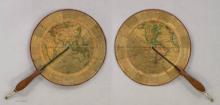
(Untitled Geographical/Astronomical Wheel).
List No
4213.000
Note
Untitled, unauthored and undated varnished card wheel 11 3/4" in diameter, printed on both sides with hand colored highlighting, and mounted with a mahogany handle with brass alidades divided 0-90 degrees. Both terrestrial hemispheres are shown, with political, geographic and astronomical features in great detail. The circumference carries numerous definitions and instructions for use and calculation e.g. "To find the Azimuth of ye Sun at any given hour of the Day; To find the Space of Time during which there is no Dark Night; etc." A wonderful, most rare device.
Author
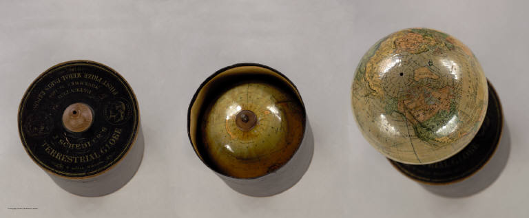
Schedler, Joseph
Full Title
J. Schedler's Terrestrial Globe, 6 inches Diameter. Patented November 24 1868. Prize Medal Paris Expos. 1867. Clerks Office of the District Court of the Southern District of New York.
List No
2477.000
Note
The globe is stored in a cylindrical box, which also serves as a stand for the globe. Alaska is part of the U.S., indicating that the globe was up to date. One of the first globes to use gores produced by lithography (Warner).
Author
Popple, Henry
Full Title
(Covers to) A Map of the British Empire in America with the French and Spanish Settlements adjacent thereto. by Henry Popple. C. Lempriere inv. & del. B Baron Sculp. To the Queen's Most Excellent Majesty This Map is most humbly Inscribed by Your Majesty's most Dutiful, most Obedient, and most Humble Servant Henry Popple. London Engrav'd by Willm. Henry Toms & R.W. Seale, 1733. (index map) ... W.H. Toms Sculp.
List No
2874A
Author
Popple, Henry
Full Title
America Septentrionalis. A Map of the British Empire in America with the French and Spanish Settlements adjacent thereto. by Henry Popple. To the Queen's Most Excellent Majesty This Map is most humbly Inscribed by Your Majesty's most Dutiful, most Obedient, and most Humble Servant Henry Popple. W.H. Toms Sculp.
List No
2874.001
Note
Index map in full color with numeric notations indicating location of the accompanying maps. With eighteen inset maps and four views (Fall of Niagara, Mexico [City], Quebec and New York). Note by Edmund Halley at the bottom verifies the accuracy of the map.
Author
Popple, Henry
Full Title
(Composite Map of) A Map of the British Empire in America with the French and Spanish Settlements adjacent thereto. by Henry Popple. C. Lempriere inv. & del. B Baron Sculp. To the Queen's Most Excellent Majesty This Map is most humbly Inscribed by Your Majesty's most Dutiful, most Obedient, and most Humble Servant Henry Popple. London Engrav'd by Willm. Henry Toms & R.W. Seale, 1733.
List No
2874.002
Note
A composite of all twenty sheets of the Popple Atlas. Sheets without color.
Author
[Abel, Henry J., Young, James H.]
Full Title
Map of the Settled Part of Wisconsin Territory compiled from the Latest Authorities by Aug. Mitchell. Philadelphia. Improved and Published by Henry J. Abel, of Wis. Ter. Compiled and Engraved by J.H. Young, Philada. 1838. (with) The Entire Territory of Wisconsin. As Established by Act of Congress. April 10, 1836.
List No
4046.001
Note
Maps in full color by county.
Author
Smiley, Thomas T.
Full Title
Middle States.
List No
0902.005
Note
In full color by state. Uncolored vignette depicts the signing of Penn's Treaty.
Author
American Publishing Company
Full Title
Rambles Through Our Country. An Instructive Geographical Game For The Young. Copyright Secured 1881. American Publishing Company. Hartford, Conn. 1886.
List No
3886.000
Note
This is meant to accompany a board game with a map of the United States (see our #5086). However, it functions as a geography of the U.S. by itself. In full color.
1-8 of 8
|