|
REFINE
Media Group: zTravel ACTUAL
1-19 of 19
Author
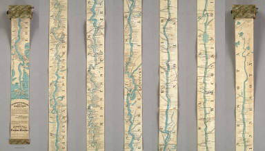
Coloney, Fairchild & Co.
Full Title
Coloney & Fairchild's Patent Ribbon Maps ... Ribbon Map Of The Father Of Waters. Geographical and Scenic Maps upon this plan of all the rivers, rail road routes, stage and coast lines in the country are in preparation.
List No
4995.000
Note
This is the most ambitious Coloney & Fairchild strip or ribbon map: it shows the Mississippi River from its delta to its source at Lake Itaska, a distance of 2600 miles. It is backed on linen and rolls into paper covered spool with a hand crank. This is the revised edition, with much additional material added on river towns by William Bowen, President of the Pilot's Association of St. Louis (this information comes from the promotion for this map printed on the Ribbon Map of New York City). No record of the first issue found, although a copy exists at the Minnesota Historical Society. The river is colored blue against a black and white background. Distances from New Orleans are printed on the river at intervals to the source. Karrow's listing is for a variant: the map printed in five strips on one sheet and folded into the 1866 edition of Edward's Gazetteer of the Mississippi River. Scarce.
Author
Colles, Christopher
Full Title
From Philadelphia to Annapolis Md. (56)
List No
2467.053
Note
Without color.
Author
American Telephone and Telegraph Company
Full Title
(Covers to) Lines And Metallic Circuit Connections. American Telephone and Telegraph Company. 15 Dey St., New York September 1898. (inset) Maine.
List No
3791A
Author
American Telephone and Telegraph Company
Full Title
Lines And Metallic Circuit Connections. American Telephone and Telegraph Company. 15 Dey St., New York September 1898. (inset) Maine.
List No
3791.001
Note
Shows the United States west to Kansas. Completed and projected telephone lines are shown. On the verso is "List of Stations Connected by Metallic Circuit Lines With the Long Distance System." On the folded cover is the statement "1000 miles and return in 5 minutes. The mail is quick, telegraph is quicker; but Long Distance Telephone is Instantaneous and you don't have to wait for an answer." Folding into self wrappers 20x9.5, with "American Telephone and Telegraph Company. Long Distance Telephone. New York. Boston, Philadelphia, Pittsburg, Cincinnati, Chicago, St. Louis. General Offices 15 Dey St. New York."
Author
American Telephone and Telegraph Company
Full Title
(Covers to) Lines and Metallic Circuit Connections. American Telephone and Telegraph Co. 18 Cortlandt St. New York. March 1, 1891.
List No
5564A
Author
American Telephone and Telegraph Company
Full Title
Lines and Metallic Circuit Connections. American Telephone and Telegraph Co. 18 Cortlandt St. New York. March 1, 1891.
List No
5564.001
Note
The map shows the communication lines in orange. On the folded cover is the statement "500 miles and return in 5 minutes. The mail is quick; telegraph is quicker; but Long Distance Telephone is Instantaneous and you don't have to wait for an answer." On the back of the map is a list of public pay stations. Folding into self wrappers 20x9.5, with "New York, Boston, Buffalo, Washington. Local and Long Distance Telephone. American Telephone and Telegraph Company. General Offices, 18 Cortlandt St. New-York. John C. Rankin Co., 34 Cortlandt St. N.Y."
Author
Colton, G.W.
Full Title
Indiana. Published By J.H. Colton & Co. No. 172 William St. New York. Entered ... 1855 by J.H. Colton & Co. ... New York. No. 41.
List No
0149.046
Note
In full color by county.
Author
[Jones, T.W., Moore, S.S.]
Full Title
Road from Philadelphia to Washington. (Maps) 9, 10, 11 and 12. W. Harrison, Junr. sc.
List No
2646.008
Note
Four uncolored maps spanning two pages. Area from Charlestown to Abington shown.
Author
U.S. General Land Office
Full Title
Department Of The Interior General Land Office J.A. Williamson, Commissioner. State of Indiana. 1878. Compiled from the official Records of the General Land Office and other sources by C. Roeser, Principal Draughtsman G.L.O. Photo lith & print by Julius Bien 16 & 18 Park Place N.Y.
List No
5456.000
Note
Printed outline color.
Author
Bradford, Thomas G.
Full Title
Indiana. Entered ... 1838, by T.G. Bradford ... Massachusetts. Engraved by G.W. Boynton.
List No
0089.019
Note
In full color.
Author
Johnson, A.J.
Full Title
A Diagram Exhibiting the difference of time between the places shown & Washington. Ex. the figures on the Dials denote the Air-line distances from Washington. By Johnson & Browning. No. 84.
List No
2905.056
Note
Dials in color and in five rings around the center dial showing Washington at 12:00.
Author
Haasis & Lubrecht
Full Title
The American Union Railroad Map Of The United States, British Possessions, West Indies, Mexico, And Central America. 1871. Published by Haasis & Lubrecht, 107 Liberty Street, New York. Smith & McDougal, Electrotypers, 82 Beekman Street, New York. (inset) Central America.
List No
3822.000
Note
This is a reworking of the Lubrecht and Rosa map "The American Continent" of 1864, and the first edition, first issue in a new format. Statistics at the top of the 1864 map are here replaced with a view "From the Atlantic to the Pacific Ocean" emphasizing the recently completed transcontinental railroad. Also, an elaborate title and view of a steam engine and train station have replaced the more subdued 1864 title. Population tables of the United States are added to the left and right sides of the map. The map itself has been updated to show political and some topographical changes of the ensuing seven years. Projected railroad lines are shown running everywhere in the west. The coloring is very bright, to match the decidedly optimistic (expansionist) flavor of the map. D.L. Guernsey published editions of 1871 and 1874 in Concord New Hampshire, with no major changes in the map. WH has an 1873 edition by Haasis and Lubrecht that adds text next to the population figures, more railroads, no changes in topography. Issued in a cover with a label in German from Wilhelm Lubrecht in Stuttgart, Germany, indicating it may have been sold to emigrants. Full color. Map has green paper edging, is dissected into 16 sections, and fold into a new gray cloth folding case 35x27 with "American Union Railroad Map Haasis & Lubrecht 1871" stamped in gilt on the spine.
Author
Melish, John
Full Title
A diagram of the United States shewing the bearings and distances of the principal places from Washington, and from each other, with a scale of time. Prepared for the Travellers directory by John Melish. (Philadelphia: Published by the Author. 1822)
List No
0501.002
Note
Distances in geographical miles. "The scale at bottom below the Scale of Longitude shows the time."
Author
[Colton, J. H., New York And Erie Railway Company]
Full Title
Map of the New York and Erie Rail Road and its connections. The most direct route between New York and all Eastern & Western cities & towns. J.H. Colton & Co. Great broad gauge double track route ... Engraved, printed and mounted by J.H. Colton & Co., 172 William St., N. York. Entered ... 1856, by J.H. Colton ... New York.
List No
5296.000
Note
Certain states are shown in full color; railroad lines shown in red.
Author
[Roeser, C. (Charles), United States. Post Office Department]
Full Title
Post route map of the states of Ohio and Indiana with adjacent parts of Pennsylvania, Michigan, Illinois, Kentucky, and West Virginia showing post offices, with the intermediate distances between them and mail routes in operation on 1st February 1884. Published by order of Postmaster General Walter Q. Gresham under the direction of C. Roeser Jr., Topographer P.O. Dept. 1884. The first edition was issued in 1870 ... (seal) Post Office Department United States Of America. "With Celerity, Certainty And Security." (with) City of Cincinnati and environs.
List No
3081.001
Note
1st issue 1870. Dissected into two sheets (each into 30 sections) labeled Western Part and Eastern Part. The usual incredible detail of these wonderful postal maps is all here - with five classes of roads shown. "The service on this Diagram brought up to date of April 1, 1884." With printed outline color by county. Sheets fold into red cloth end sheets labeled with the above title, and into a new red cloth folding case 23x14 with "Post Route Map Of Ohio & Indiana 1884" stamped in gold on the spine.
Author
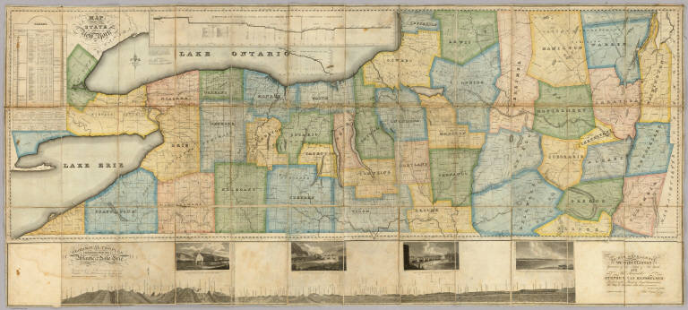
[Dey, J. Ogden, Vance, David H.]
Full Title
Map of the Western Part of the State Of New York. 1823. By D.H. Vance. Improved and enlarged to the east boundary of the State by J. Ogden Dey 1824. Engraved by Balch, Rawdon & Co. To His Excellency De Witt Clinton ... And ... Stephen Van Rensselaer ... This Map is Inscribed with their permission. By The Publisher John Ogden Dey. Albany January 1825. Copy Right Secured. (with four inset profiles).
List No
4999.001
Note
Vance published the upper and western part of this map in 1823 (see Streeter 3818). Dey enlarged it in 1824 and 1825 by adding an eastern portion, taking the state to its eastern boundary with New England, and also adding a lower section that includes a "Geological Profile Extending from the Atlantic to Lake Erie" (which shows the Erie Canal) and four views of the complete Erie Canal. On the main map is a profile of the western and middle sections of the Erie Canal and tables of statistics and geological remarks. The whole production is a celebration of the recently completed Erie Canal. Streeter calls the 1823 issue a "fine large scale colored map." Full color by county. Map has silk edging and is dissected into 36 sections. Folds with marbled paper end sheets, and lies loosely in quarter leather marbled paper covered boards 30x17 with leather ties; "Dey's Improved Map Of N. York" is stamped in gilt on the spine. Scarce.
Author
[Garcia Cubas, Antonio, 1832-1912, Ramirez, Jose Fernando, 1804-1871]
Full Title
Cuadro historico-geroglifico de la peregrinacion de las tribus Aztecas que poblaron el Valle de Mexico. Num. I. Acompanado de algunas esplicaciones para su inteligencia, por D. Jose Fernando Ramirez, Conservador del Museo Nacional. Litog. de Iriarte y Ca., calle de Santa Clara no. 23. Munozguren litogo. Imprenta de Lara. Entegra 29a. (1858)
List No
4116.031
Note
Lithographed pictorial map. Surrounded by explanatory text. "Atlas mexicano, por Antonio Garcia y Cubas Cuadro I."
Author
International & Great Northern Railroad
Full Title
Colonists' and emigrants' route to Texas. Rand, McNally & Co., Engr's, Chicago. (untitled inset map of the eastern half of the United States). (1878?)
List No
5050.001
Note
A birds eye view of Texas showing the lines of the International & Great Northern Railroad. With the stamp of Henry H. Hannan, Swan Creek, Ohio. Includes 5 drawings: Pictures of productions on the International & Great Northern Railroad.
Author
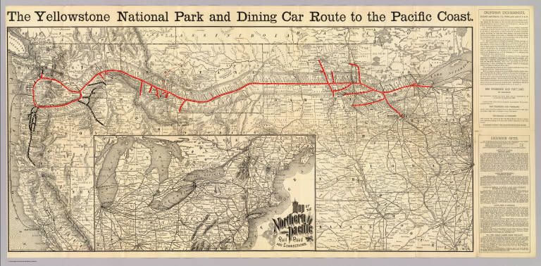
Northern Pacific Railroad Company
Full Title
The Yellowstone Park and dining car route to the Pacific Coast. Rand, McNally & Co., Engr's, Chicago. (inset) Map of the Northern Pacific Rail Road and connections.
List No
3570.001
Note
Relief shown by hachures. Map shows railroad route in red, otherwise is printed without color. Generally covers area from Fresno, Calif. and Cairo, Ill. north, and from Chicago west, excluding Colorado, Utah and most of Nevada and Nebraska. Inset covers northeastern U.S.
1-19 of 19
|