|
REFINE
Media Group: qtvr
1-73 of 73
Author
Lucas, Fielding Jr.
Full Title
United States. B.T. Welch & Co. Sc. Drawn & Published by F. Lucas Jr. Baltimore.
List No
4584.045
Note
Full color by state and region.
Author
Bachmann, John
Full Title
Panorama of the Seat of War. Birds Eye View Of Virginia, Maryland Delaware And The District Of Columbia. John Bachmann, Publisher, 115 & 117 Nassau St., New York. Entered ... 1861 by John Bachmann ... New York. Drawn from Nature and Lith. by John Bachmann.
List No
0043.001
Note
1st issue; a 2nd issue shows smoke at Manassas. This view joins with the North and South Carolina view and the Florida and Georgia view to form one continuous panorama of the east coast of the Confederacy. Full color. Bound in black leather covers 38x3
Author
[Carey, Mathew, Lewis, Samuel]
Full Title
The State of Pennsylvania reduced with permission from Reading Howell's Map, by Samuel Lewis. Smither Sculp. Engraved for Carey's American Edition of Guthrie's Geography improved.
List No
2542.010
Note
Uncolored.
Author
[Mitchell, Samuel Augustus, Young, James H.]
Full Title
A New Map Of Texas, With The Contiguous American & Mexican States by J.H. Young. Philadelphia: Published by S. Augustus Mitchell. 1836. Sold by Mitchell & Hinman No. 6 North Fifth Street. Engraved by J.H. Young. Entered ... 1835 by S. Augustus Mitchell ... Pennsylvania.
List No
5140.001
Note
The second edition, Streeter showing editions of 1835, 1836, 1837, 1838, 1839, 1842, 1843, and 1845. This map covers about the same area as the David Burr map (see our #5024) but shows the boundary between Texas and Louisiana more correctly. Three text insets are titled "Remarks on Texas," "Land Grants," and "Rivers of Texas." A scarce, important early Texas map, not listed in Martin and Martin. Full color. Folded into black leather covers 12.5x7.5 with "Mitchell's Map Of Texas" and a decorative border stamped in gilt.
Author
Melish, John
Full Title
Map of the United States with the contiguous British & Spanish Possessions Compiled from the latest & best Authorities By John Melish. Engraved by J. Vallance & H.S. Tanner. Entered ... 6th day of June 1816. Published by John Melish Philadelphia. (inset) West Indies.
List No
5168.001
Note
With insets of the West Indies and a Statistical Table. This map has the distinction of being the first large scale detailed map made in the U.S. that showed the entire country from the Atlantic to the Pacific. This copy is an early state of the first edition -this is Martin's third state of the first edition and Ristow's fourth state (Ristow discovered a town and trail added in Ohio - Adelphi - making for a sub state of Martin's third state). The first state was an incomplete proof copy, making this the second/third state of the completed copy. The differences between this and the first complete state are small: Mansfield, Wooster, and Adelphi (and a trail from Adelphi to Athens and Chillicothe) added in Ohio, and "Vevay or" added before "Swiss Vineyards" in southeastern Indiana. Martin and Ristow identify seven states of the 1816 edition. Melish published new editions in 1818 (five states), 1819 (two states), 1820 (eight states), 1822 (two states), and 1823 (one state) for a total of twenty five different issues. Notwithstanding the many issues, the map has become extremely rare. A book accompanied the map (though issued separately) titled "A Geographical Description of the United States..." (see our #2424). Outline color by state or territory. This copy is dissected into 40 sections, backed with linen, and edged in brown cloth. It folds with marbled end sheets into new blue cloth folding boards and slip case 24.5x16.5 with leather label on spine reading "Melish. Map Of The United States. 1816" in gold.
Author
[Hoffman, Hoffmann, Charles F., J.T. Gardner, Whitney, J.D., Geological Survey of California]
Full Title
Geological Survey Of California, J.D. Whitney, State Geologist. Map of a portion of the Sierra Nevada adjacent to the Yosemite Valley from surveys made by Chs. F. Hoffmann and J.T. Gardner, 1863-1867.Map of a portion of the Sierra Nevada adjacent to the Yosemite Valley.
List No
4824.000
Note
This map is among the most detailed and largest scale maps of Yosemite issued during this part of the 19th century, rivaled only by the Wheeler Survey map of Yosemite published in 1883. This is a second issue of this map, here mounted as a wall map. This is the same as the first issue that appeared with the Yosemite Guide Book (see our #4212) except that it adds "Hite's Cove" on the Merced River just slightly west of its junction with Devil's Gulch. In the (1870) third issue (our #4650) Hite's Cove is relocated to a point just south of the Merced on the road titled "Road to Hite's Cove" and the erasure of the prior label is apparent. We have dated this second issue (1869) as a best guess. With black top and bottom rollers, and pink linen edging. Map is without color.
Author
Hutchins, Thomas
Full Title
A New Map of the Western Parts of Virginia, Pennsylvania, Maryland and North Carolina; Comprehending the River Ohio, and all the Rivers, which fall into it; Part of the River Mississippi, the Whole of the Illinois River, Lake Erie; Part of the Lakes Huron, Michigan &c. And all the Country bordering on these Lakes and Rivers. By Thos. Hutchins, Captain in the 60 Regiment of Foot. London, Published according to Act of Parliament Novembr. ye 1st, 1778 by T. Hutchins ... Engrav'd by T. Cheevers.
List No
5044.000
Note
This map was published separately and at the same time as Hutchins' "Topographical Description..." and should accompany the book. Streeter calls it "by far the best map of the west printed to that time." It was the first large scale map of the area west of the Allegheny Mountains based on personal observations, although Hutchins gives credit to Lewis Evans' "Map of the Middle Colonies" as the best prior source of information about the area. The map contains extensive printed notes which describe important aspects of the country depicted. This map ranks with the most important American maps issued in the 18th century and is now rare. Hutchins later became the first Geographer of the United States. With outline color. Map is dissected into 32 sections and mounted on linen. Folds into new green cloth folding boards and quarter leather green cloth slip case 24x16 with "Hutchin's New Map Of Western Parts Of Virginia, Etc. 1778" on the spine in gold.
Author
Eddy, John H.
Full Title
Map Of The Country Thirty Miles Round the City of New York. Designed & Drawn by I.H. Eddy of N. York, 1812. To Dewitt Clinton Esqr. Mayor of the City of New York This Map is inscribed by his respectful friend The Author. Published by Prior & Dunning, Map & Chart sellers No. 111 Water Street. Copy Right secured according to Law. Engrd. by P. Maverick, Newark, N. Jersey.
List No
3472.000
Note
1st edition. Other editions of 1828, 36, 39, 42. Reengraved by Colton in 1846 (see our 1853 edition). Rare. Stokes: "This is one of the most complete, accurate, and beautiful early engraved maps showing New York and its environs." It was engraved by Peter Maverick. Stokes states that J. M. Atwood reengraved this map in 1846 for Colton (although the reengraving changed the map substantially). The 1828 reissue was in guide book form by Hooker and Blunt, Disturnell issued the 1836 and 39 editions (see our 1839 issue), and Goodrich issued the 1842 edition. Stokes dates the map at 1811 because of a reference to its publication in the October, 1811 issue of The American Medical and Philosophical Register. Eddy's name is written "I.H. Eddy" on the map, the "I" probably mistaken by the engraver for the "J." Map has outline color; dissected into 15 sections and mounted on linen. Folds with a gray marbled end sheet into a new gray cloth folding case 21x13 with "Thirty Miles Round New York J. Eddy 1811" stamped in gilt on the spine.
Author
[Mitchell, Samuel Augustus, Young, James H.]
Full Title
Map Of The United States By J.H. Young. Published by S. Augustus Mitchell. Entered ... Pennsylvania, October 10th, 1831 by S. Augustus Mitchell. Engraved by J.H. Young, D. Haines & F. Dankworth. (inset) A Map Of North America Including All The Recent Geographical Discoveries. (with 10 additional inset maps).
List No
2723.001
Note
1st edition, 1st wall map issued by Mitchell. This edition does not have the counties delineated and numbered. Ristow mistakenly says all editions have the townships (he means counties) numbered, but this one, the first, does not, thereby eliminating the index of counties and thus showing more of the western territory. This map predates the Traveler's Guide by 1 year, and thus is Mitchell's first "original" production, as opposed to the Finley material he reissued as the American Atlas and Pocket Maps. The case for the map has a leather label saying "Traveler's Map of the United States." Copyright date is October 10, 1831. There is no other date on the map. Ristow thinks the map was issued in early 1832, but it is not in Phillips until 1834 edition (which probably has the counties indicated by number and the 1831 copyright), so Ristow may not have seen this edition, but rather the 1834. The map is hand painted in bright full color by state (insets by county), dissected in 24 sections with green paper end sheets, mounted on linen and edged in pink silk. The covers 24x20 are half red leather marbled paper covered boards with ties and a leather label embossed with "Traveller's Map Of The United States" in gilt.
Author
[Blaskowitz, Charles, Faden, William, 1750?-1836]
Full Title
A Topographical Chart of the Bay of Narraganset in the Province of New England, with all the Isles contained therein, among which Rhode Island and Connonicut have been particularly Surveyed, Shewing the true position & bearings of the Banks, Shoals, Rocks &c. as likewise the Soundings: To which have been added the several Works & Batteries raised by the Americans. Taken by Order of the Principal Farmers on Rhode Island, By Charles Blaskowitz. Engraved & Printed for Wm. Faden, Charing Cross, as the Act directs, July 22d 1777. To the Right Honourable Hugh Earl Percy, Baron Percy, Lucy, Poinings, Fitz-Paine, Bryan & Latimer, Lieutenant General of His Majesty's Forces in Great Britain and America. This Plan is ... most humbly Inscribed, by ... Wm. Faden. (in manuscript) Hinck S.
List No
3951.001
Note
The most important map of the area around Providence and Newport issued during the Revolution. With hand painted color. A separately issued copy dissected into 16 sections and mounted on linen. Folds into a marbled slip case 24x17 with a paper label with "Rhode Island" printed in manuscript.
Author
Townsend, Dennis
Full Title
Townsend's Patent Folding Globe. Patented by Dennis Townsend Feb. 16, 1869. (expanded globe).
List No
3891.002
Note
Globe shown after expansion - 6 inches in diameter. Globe in full color with numbered counties and features. Globe has rings on both ends which allow it to be easily expanded and to be hung. Instructions are also given for mounting the globe on a stand.
Author
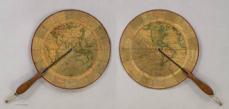
Anonymous
Full Title
(Untitled Geographical/Astronomical Wheel).
List No
4213.000
Note
Untitled, unauthored and undated varnished card wheel 11 3/4" in diameter, printed on both sides with hand colored highlighting, and mounted with a mahogany handle with brass alidades divided 0-90 degrees. Both terrestrial hemispheres are shown, with political, geographic and astronomical features in great detail. The circumference carries numerous definitions and instructions for use and calculation e.g. "To find the Azimuth of ye Sun at any given hour of the Day; To find the Space of Time during which there is no Dark Night; etc." A wonderful, most rare device.
Author
Holbrook's Apparatus Mfg. Co.
Full Title
(Untitled Terrestrial Globe).
List No
5229.000
Note
This three inch solid wood, paper covered globe is hinged to open and reveal the western and eastern hemispheres on a flat globular projection on the two inside surfaces. It was used as a teaching device to show students how a globe can be represented on a flat surface. The date is estimated by Warner, based on Holbrook's move to Wethersfield, Connecticut in 1854 to use convict labor to manufacture his globes (including this one). Full color.
Author
Cushee, Richard
Full Title
A New Globe of the Earth by R. Cushee 1731.
List No
3992.000
Note
Scarce 3 inch diameter pocket globe in black fishskin case lined with colored celestial gores. California is shown as an island, and eastern Australia is not mapped. A very early example of a pocket globe.
Author
Geographic Educator
Full Title
Terrestrial Globe - 6" Dia. - Geographic Educator. New York, U.S.A. Printed in U.S.A. Copyright 1927.
List No
0296.000
Note
Opens up to reveal six sections in layers. The opening portions are like a puzzle, with the various states its pieces. Layers from bottom to top include: 1. Australia. 2. South America. 3. Africa. 4. Asia. 5. North America (with states delineated). 6. Europe. Total height from base to top of the globe is eleven inches. The globe itself is 5.5 inches.
Author
Wilson, James
Full Title
A three inch Terrestrial Globe by Wilson's & Co. Alby. (with) A Celestial Globe, With all the Stars of the 1st. 2d. & 3d. Magnitudes. By Wilson & Son's Alby.
List No
3122.000
Note
The date of the globes is an estimate. Paired with a three inch celestial globe. On a turned wooden stand with four black ball feet, full height from base to top, 5 inches. Warner says that Wilson changed the business name from Wilson & Co. to Wilson & Sons in 1822. The celestial globe this is paired with is by Wilson & Sons, so I assume 1822 as the only year globes were made with both business names. The globe is very well engraved, showing much detail in the continents for its small size. Longitude is given from both Washington and London. Kimball notes that David Wilson, James' son, did the engraving for a new edition of the three inch globes in the early 1820's, which I assume are these globes. David later had brief success as a miniature painter, utilizing the same delicate engraving skills which he applied to these extremely well engraved globes. The three inch globe was also sold in pocket form with the celestial sphere on the inside of the case and on a stand with horizon ring and brass meridian. On this turned wooden stand version, the globe is mounted horizontally, an unusual presentation. Wilson made the first globes in the United States, with 1810 his first year of production and 1850 (by Cyrus Lancaster) his last.
Author
Loring, Josiah
Full Title
Loring's Terrestrial Globe containing all the Late Discoveries and Geographical Improvements, also the Tracks of the most celebrated Circumnavigators. Compiled from Smith's new English Globe, with additions and improvements by Annin & Smith. Boston: Josiah Loring, 136 Washington St. 1833.
List No
2899.000
Note
1st terrestrial globe by Loring. Loring's first globe was the 12" celestial of 1832. Loring's address is 136 Washington Street, Boston. Accompanied by the 12" celestial globe of 1833. Both the terrestrial and celestial were copied (with credit given) from C. Smith's English globes. Annin & Smith of Boston did the engraving. Loring was succeeded in business by Gilman Joslin who continued to produce globes under Loring's name until the 1850's (Warner). These two globes were commended by the Judges at the 1833 fair of the Massachusetts Charitable Mechanic Association (Warner). Four legged table model with horizon ring. Total height from bottom of base to top of the meridian is 17.5 inches.
Author
[Lancaster, Cyrus, Wilson, James]
Full Title
Wilson's New American Thirteen Inch Terrestrial Globe, Exhibiting with the Greatest Possible Accuracy, The Positions of the Principal Known Places of the Earth; with the Tracks of Various Circumnavigators, Together with New Discoveries and Political Alterations Down to the present Period: 1836. By Cyrus Lancaster, Albany St. N.Y. S. Wood & Sons Agents N. York.
List No
4992.000
Note
The second year of production of Wilson's Thirteen Inch Globe by Cyrus Lancaster. Compared to the last Wilson issue of 1834 (see our #4310) we cannot detect any changes in the geography. In fact, both the 1834 and the 1836 are out of date regarding the United States - Arkansas is shown in enlarged pre 1824 form and Northwestern Territory is shown where Michigan Territory should be. But then most of the early American globes did not keep current with the changes to political geography. With a four leg table stand. Total height from base to top is 18 inches.
Author
Loring, Josiah
Full Title
Loring's Celestial Globe Containing all the known Stars, Nebulae &c. Compiled from the Works of Wollaston, Flamsted, De la Caille, Havelius, Mayer, Bradley, Herschel, Maskelyne. The Transactions of the Astronomical Society of London &c. &c. (From Smith's New English Globe.) Boston, Josiah Loring, 136 Washington St. 1833. Annin & Smith sc.
List No
2897.000
Note
2nd issue - this was 1st issued in 1832. Engraved by Annin & Smith. Loring's address is 136 Washington Street, Boston. Shows stars of magnitudes 1 to 9 and nebulae. Accompanies the 1833 Terrestrial 12" globe. Four legged table model with horizon ring. Total height from base to top is 17.5 inches, with the globe measuring 12 inches.
Author
Rand McNally and Company
Full Title
Rand, McNally & Co's. New Eighteen Inch Terrestrial Globe ... Copyright, 1894, by Rand, McNally & Co.
List No
4225.000
Note
Rand McNally's first globe was a 12" terrestrial produced in 1887 (Warner). This 18" floor globe appeared seven years later and is an impressive production. The graphic elements are very clearly rendered, in the best fashion of wax engraving. A horizon ring is still employed, with a metal stand that is unique and unusual, apparently of the "Aesthetic Revival" school of design that flourished at the end of the 19th century. Isothermal lines are shown for January and July, as are submarine telegraph cables. The gores show a water mark "& Sons" with a "96" below, so this globe had been issued in 1896. The political geography is pre 1898 and the Spanish American War (see Cuba, etc.). Total height from base to top of globe is 48 inches.
Author
[Franklin Globes, Nims, H.B. & Co.]
Full Title
The Franklin Terrestrial Globe 12 Inches in Diameter Containing All The Geographical Divisions & Political Boundaries to the present date. Carefully Compiled from the best Authorities. H.B. Nims & Co. Troy, N.Y. Rae Smith, Engraver. N.Y.
List No
2816.000
Note
Engraved by Rae Smith, New York. On a Serpentine stand with full horizon ring and brass meridian. Merriam & Moore issued the first Franklin Globes in Troy, New York, around 1850, and the Globes were issued by various successor firms up to about 1896, in sizes ranging from 6" to 30". Dated by "National Park" shown for Yellowstone National Park (established 1872). Globe measures 12 inches in diameter with its full height including base at 18 inches.
Author
Wilson, James
Full Title
A New American Terrestrial Globe on which the Principal Places of the Known World are Accurately laid down with the traced attempts of Captain Cook to discover a Southern Continent by James Wilson 1811.
List No
4994.000
Note
Wilson's first dated globe, issued one year after his undated 1810 globe, also 13 inches. This is the first dated globe issued in the United States. In 1812 Wilson issued his first Celestial Globe. This thirteen inch Terrestrial Globe is on a four leg table stand. Total height from base to tip is 18 inches.
Author
[Copley, Charles, Joslin, Gilman]
Full Title
Improved Globe, Boston. Manufactured by Gilman Joslin, Corrected to 1870. Entered according to Act of Congress in the year 1852 by Charles Copley ... New York. (Terrestrial Globe).
List No
2920.001
Note
16" pair of Terrestrial and Celestial globes. These globes were originally issued by Copley and sold by Blunt in New York in 1852. Joslin revised and reissued them (this pair) in 1869, continuing until the 1890's (Warner). These are both floor stand models and are illustrated in Joslin's catalogue of the early 1870's (see our copy). Franklin Globes also issued the Copley Globes, but they may have been made by Joslin or Nims for Franklin (Warner). "National Park" is shown in the U.S. where Yellowstone Park was created in 1872, but we think this is anticipatory rather than after the fact. The "corrected to 1870" was usually done a year or two before the date (Coffeen). The Copley globes are beautifully executed, have a "modern" look, and are "extremely detailed, even to the point of obscurity" (Warner). Warner further states that "no examples of the Joslin 1869 state of these globes are known." This pair may be the only survivors. Copley won a gold medal in 1852 from the American Institute for the globes (see Transactions of the American Institute 1852, p124-5). Warner lists a Franklin 16" Terrestrial (3-88) by Nims that is similar to this. Total height from base to top is 43 inches.
Author
Betts, John
Full Title
By The Queens Royal Letters Patent. Betts's New Portable Terrestrial Globe. Compiled from The Latest and Best Authorities. London, John Betts, 115 Strand.
List No
4362.000
Note
The first edition of Betts' collapsible 15-inch "umbrella" type globe. The date is estimated from the U.S. geography. Later editions continued to the end of the century. In the original wooden box with advertisements for Betts' geographical products. It is interesting that the color is printed onto the gores - thus being a fairly early example of color lithography.
Author
Betts, John
Full Title
By The Queens Royal Letters Patent. Betts's Portable Terrestrial Globe. Compiled from The Latest and Best Authorities. British Empire coloured red. London: George Philip & Son Ltd. 32 Fleet Street. Liverpool: Philip Son & Nephew Ltd. 45-51, South Castle Street.
List No
4478.000
Note
Undated 15-inch hanging globe, with the date of 1915 estimated by the Panama Canal (1914) and Austria Hungary (prior to WW I). George Philip took over production from Betts around 1880, and examples appear as late as 1932 (Welsh Sale #364).
Author
Cheney, Flavius
Full Title
12 Inch Globe Manufactured By The Cheney Globe Co., Mystic, Conn. Copyright, 1896 by Flavius Cheney.
List No
4199.000
Note
An uncommon 12-inch globe with crudely printed gores, colored politically, although the key indicates that it was sometimes colored to show the heights of land and depth of oceans (Warner: "In 1896 Cheney obtained a copyright on a 12-inch terrestrial globe, the colors indicating the height of land and depth of water."). Cheney published a "Globe Manual for Schools" in 1882, with later editions to 1897. The Cheney Globe Company was in business from 1888 to about 1900. This globe is a desk model with a three leg iron stand and horizon ring, total height 20 inches.
Author
[Cary, John, ca. 1754-1835, Cary, William]
Full Title
Cary's New Terrestrial Globe Exhibiting The Tracks and Discoveries made by Captain Cook; Also those of Captain Vancouver on the Northwest Coast of America and M. De La Perouse, On the Coast of Tartary, Together With every other Improvement collected from Various Navigators and Travellers to the present time. London: Made & Sold by J. & W. Cary, Strand, March 1st, 1816. With Corrections and Additions to 1818.
List No
3401.000
Note
Dated March 1st, 1816, With Corrections and Additions to 1818. 2nd edition, 1st edition was either 1816 or 1817 depending on the authority. Uses Arrowsmith for the American Northwest. Cary issued globes in 3.5", 9", 12" and 21" sizes starting in 1792 (Fordham) and added the 18" in 1816/17. During this period he issued the globes with his brother William, later with his brother George. The globe is beautifully drawn with precision in a style similar to Cary's maps, lacking any ornamentation. The stand is a four leg table type, with horizon ring. An 18-inch globe, measuring 25-inches from base to tip.
Author
Holbrook, Charles W.
Full Title
Chas. W. Holbrook's Twelve inch Globe Containing the Latest Political Divisions, And Ocean Currents. Revised to Date. 1890.
List No
0326.000
Note
Interesting "modern" iron stand. Globe shows isothermal lines and currents. Globe measures 12-inches and stands 22-inches from top to base.
Author
[Copley, Charles, Joslin, Gilman]
Full Title
Improved Globe, Boston. Manufactured by Gilman Joslin, Corrected to 1870. Entered according to Act of Congress in the year 1852 by Charles Copley ... New York. (Celestial Globe).
List No
2920.002
Note
16" pair of Terrestrial and Celestial globes. These globes were originally issued by Copley and sold by Blunt in New York in 1852. Joslin revised and reissued them (this pair) in 1869, continuing until the 1890's (Warner). These are both floor stand models and are illustrated in Joslin's catalogue of the early 1870's (see our copy). Franklin Globes also issued the Copley Globes, but they may have been made by Joslin or Nims for Franklin (Warner). "National Park" is shown in the U.S. where Yellowstone Park was created in 1872, but we think this is anticipatory rather than after the fact. The "corrected to 1870" was usually done a year or two before the date (Coffeen). The Copley globes are beautifully executed, have a "modern" look, and are "extremely detailed, even to the point of obscurity" (Warner). Warner further states that "no examples of the Joslin 1869 state of these globes are known." This pair may be the only survivors. Copley won a gold medal in 1852 from the American Institute for the globes (see Transactions of the American Institute 1852, p124-5). Warner lists a Franklin 16" Terrestrial (3-88) by Nims that is similar to this. Total height from base to top is 43 inches.
Author
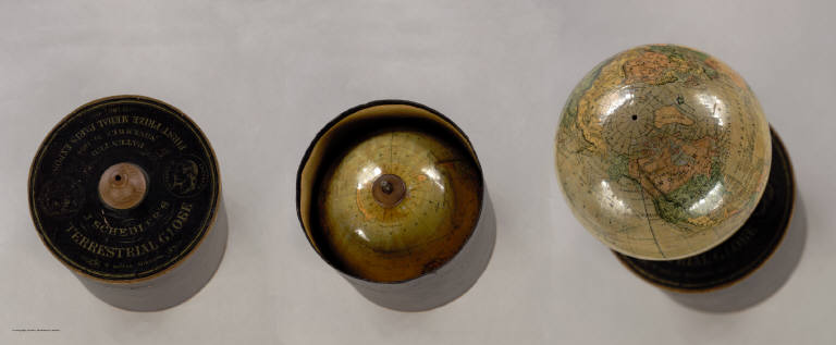
Schedler, Joseph
Full Title
J. Schedler's Terrestrial Globe, 6 inches Diameter. Patented November 24 1868. Prize Medal Paris Expos. 1867. Clerks Office of the District Court of the Southern District of New York.
List No
2477.000
Note
The globe is stored in a cylindrical box, which also serves as a stand for the globe. Alaska is part of the U.S., indicating that the globe was up to date. One of the first globes to use gores produced by lithography (Warner).
Author
Carey, Mathew
Full Title
Missouri Territory formerly Louisiana. Bower, Sc.
List No
4577.027
Note
Territory shown in outline color from Louisiana in the south to Lake Winnepeg in the north and the Pacific Ocean in the west.
Author
[Mitchell, John, Raynal, G.T., Zatta, Antonio]
Full Title
Le Isole Bermude. (title cartouche) Le Colonie Unite dell' America Settentrle. di Nuova Projezione Ass. Ee. Li Signori Riformatori dello Studio di Padova. Venezia 1778, Presso Antonio Zatta, con Privilegio dell' Eccellentissimo Senato.
List No
5007.001
Note
In full color. Map appears on an unfurled scroll laid atop a drawing of the local flora and fauna. Large elaborate drawing surrounds the title cartouche for 12 map sheets when viewed as a composite.
Author
Holdredge, Sterling M.
Full Title
(Illustrated Title Page to) State, Territorial and Ocean Guide Book of the Pacific: Containing The Time and Distance Tables ... on or Connecting with the Pacific Coast and the Interior ... To Which Are Added Nine Large and Reliable Maps Showing Principal Towns, Routes of Communication, etc. San Francisco: Published Semi-Annually by Sterling M. Holdredge. ... 1866.
List No
2544A
Note
Cowen p289. 2nd edition, 1st was 1865. Only two editions are known, 1865 and 1866 (Wheat). Wheat praised these maps and illustrated all nine. With a beautiful chromo litho title page illustrated with a globe showing the western hemisphere. Transportation scenes surround globe, including ships, a riverboat, train, and stagecoach. The nine maps are all double page and full of interesting information. They were lithographed by Grafton T. Brown, the first black lithographer in San Francisco. Rare. Book bound with cloth covers and "Guide Book of the Pacific" on the spine.
Author
Popple, Henry
Full Title
(Composite Map of) A Map of the British Empire in America with the French and Spanish Settlements adjacent thereto. by Henry Popple. C. Lempriere inv. & del. B Baron Sculp. To the Queen's Most Excellent Majesty This Map is most humbly Inscribed by Your Majesty's most Dutiful, most Obedient, and most Humble Servant Henry Popple. London Engrav'd by Willm. Henry Toms & R.W. Seale, 1733.
List No
2874.002
Note
A composite of all twenty sheets of the Popple Atlas. Sheets without color.
Author
Popple, Henry
Full Title
A Map of the British Empire in America with the French and Spanish Settlements adjacent thereto. by Henry Popple. (Sheet 17).
List No
2874.019
Note
First panel of the last column includes part of Central America and the title cartouche. Drawing depicts natives and local flora and fauna. In the background, the British are loading a ship and talking. Uncolored.
Author
Maclure, William
Full Title
A Map of the United States of America. By Samuel G. Lewis.
List No
2749.001
Author
Darton, William
Full Title
North America, from the Latest Authorities. Engraved by Willm. Darton. No. 58, Holborn Hill. Published Jany. 26, 1814 by Willm. Darton, London.
List No
3407.001
Note
Very early map puzzle. The map is from Darton's Union Atlas (see our copy, #4767). Map has some color and has obviously faded with some small sections missing from a few pieces.
Author
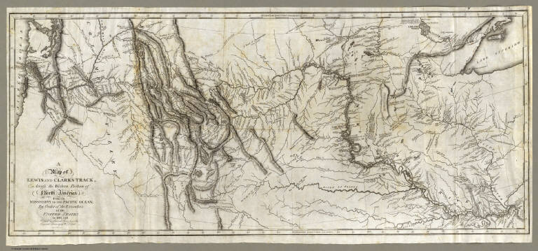
[Allen, Paul, Biddle, Nicholas, Clark, William, Lewis, Meriwether]
Full Title
A Map of Lewis and Clark's Track, Across the Western Portion of North America From the Mississippi to the Pacific Ocean; By Order of the Executive of the United States, in 1804, 5 & 6. Copied by Samuel Lewis from the Original Drawing of Wm. Clark. Smal. Harrison fct.
List No
3493.001
Note
Uncolored map showing topography and rivers in the region as well as towns, Indian villages, and population figures. Bound into the front of volume one.
Author
[McCleary, Samuel, Pierce, John]
Full Title
McCleary & Pierce's Geographical Analysis of the State of New York, Albany 1850. Patented Sep. 1849.
List No
4086.001
Note
Puzzle in full color by county. Surrounding pieces showing adjoining states and bodies of water colored dark brown and blue. The counties are numbered, named by county and county seat.
Author
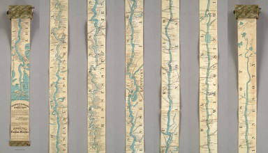
Coloney, Fairchild & Co.
Full Title
Coloney & Fairchild's Patent Ribbon Maps ... Ribbon Map Of The Father Of Waters. Geographical and Scenic Maps upon this plan of all the rivers, rail road routes, stage and coast lines in the country are in preparation.
List No
4995.000
Note
This is the most ambitious Coloney & Fairchild strip or ribbon map: it shows the Mississippi River from its delta to its source at Lake Itaska, a distance of 2600 miles. It is backed on linen and rolls into paper covered spool with a hand crank. This is the revised edition, with much additional material added on river towns by William Bowen, President of the Pilot's Association of St. Louis (this information comes from the promotion for this map printed on the Ribbon Map of New York City). No record of the first issue found, although a copy exists at the Minnesota Historical Society. The river is colored blue against a black and white background. Distances from New Orleans are printed on the river at intervals to the source. Karrow's listing is for a variant: the map printed in five strips on one sheet and folded into the 1866 edition of Edward's Gazetteer of the Mississippi River. Scarce.
Author
Mitchell, Samuel Augustus
Full Title
Map of the United States and Texas Engraved to Illustrate Mitchell's School and Family Geography. No. 4. (with) Map of Mexico and Guatimala ... No. 5. Engraved by W. Williams. Entered ... 1839, by S. Augustus Mitchell ... Connecticut.
List No
0523.003
Note
In full color by state, territory, or country.
Author
Mitchell, Samuel Augustus
Full Title
Map of the United States and Texas. (with) Map of Mexico and Guatimala. Entered ... 1839, by S. Augustus Mitchell ... Pennsylvania.
List No
0522.002
Note
Without color. Dotted divisions between the states, territories, and countries. Mountains and deserts shown.
Author
[Fremin, A.R., Gaultier, J., Logerot]
Full Title
Amerique du Nord; Amerique du Sud; Oceanie; Afrique; Asie; Europe et ses Chemins de fer; France et ses Chemins de fer.
List No
4782.001
Note
Each puzzle map with pink borders and ribbon ties. All maps in full color.
Author
Garcia Cubas, Antonio, 1832-1912
Full Title
Carta Hydrografica. VII. A. Garcia Cubas. Propiedad De Los Editores. Publicado por Debray Sucesores - Mexico.
List No
2693.007
Note
The water system of Mexico. An inset map shows the relative length of the rivers throughout the country. The map is surrounded by drawings of the country's rivers, waterfalls, and lakes. In full color.
Author
[Dutton, Clarence E. (Clarence Edward), 1841-1912, Holmes, William Henry, 1846-1933]
Full Title
Panorama from Point Sublime. [Part I. Looking East.] W(illiam) H. H(olmes). Atlas Sheets XV. Julius Bien & Co. lith. U.S. Geological Survey, Geology of the Grand Canon District.
List No
4713.016
Note
In full color. First of three sheets.
Author
Tanner, Henry S.
Full Title
A Map of North America, Constructed According To The Latest Information: by H.S. Tanner. S.W. Sheet. Entered ... 27th day of May 1822, by H.S. Tanner ... Pennsylvania. Engraved & Published by H.S. Tanner. Philadelphia. 1822. Printed by Wm. Duffee. American Atlas.
List No
5388.011
Note
Third of four sheets comprising the North American map. Scale measured at 10 degrees latitude. In full color. This section contains the title cartouche with an elaborate drawing that includes Natural Bridge in Virginia and the Falls of Niagara. This section includes California and Mexico.
Author
Tanner, Henry S.
Full Title
(Composite of) A Map of North America, Constructed According To The Latest Information: by H.S. Tanner. S.E. Sheet. Entered ... 27th day of May 1822, by H.S. Tanner ... Pennsylvania. Engraved & Published by H.S. Tanner. Philadelphia. 1822. Printed by Wm. Duffee. American Atlas.
List No
5388.013
Note
Composite of the four North American map sheet. Scale measured at 10 degrees latitude. In full color.
Author
Paul, Rene
Full Title
Map Of The City Of St. Louis Compiled from information in the possession of Rene Paul Esqr. 1844. Published By Twichel & Cook N.W. Cor. Main & Pine Sts. St. Louis Mo. Engraved at the Office of J.T. Hammond, By T. Twichel. N.W. Cor. Main & Pine Streets. St. Louis Mo.
List No
4197.001
Note
Second edition. In covers with printed paper label "Map of the City of St. Louis, 1844." Engraved map, with three vignettes, two of buildings and one of a steamboat on the Mississippi River. Table of population statistics and a key to the important buildings located on the map. Color coded by ward. A beautiful map, exquisitely colored, and scarce. Rene Paul, the city surveyor, first issued this map in 1842. In 1835 Paul did a larger map of St. Louis separately and for Eugene Charles Dupre's Atlas of the City and County of St. Louis (illustrated in Ristow p.296, Karrow 9-1553-4). This earlier map was lithographed by Lehman & Duval. Folded into dark brown cloth covers 13x8 with "Map Of The City Of St. Louis, 1844" printed in black on yellow paste down label.
Author
Bancroft, A.L.
Full Title
Bancroft's Map Of California, Nevada, Utah And Arizona. Published By A.L. Bancroft & Compy. Booksellers & Stationers, San Francisco, Cal. 1873. Entered ... by A.L. Bancroft & Company ... Washington, D.C.
List No
0046.000
Note
1st edition was 1864. From Bancroft's Map the of Pacific States which appeared in 1863. Wheat says Bancroft changed the large Pacific States map in 1870, but we believe that the smaller maps such as this continue to be from the original 1863 or 1867 plates, updated to show railroad expansion and topographical changes. With black top and bottom rollers. Full color by county.
Author
[Hayden, F.V., Holmes, William Henry, 1846-1933]
Full Title
Panoramic Views. W.H. Holmes. U.S. Geological and Geographical Survey of the Territories. F.V. Hayden in Charge. Sheet XX.
List No
4576.022
Note
Four panoramic views: 1) The Twin Lakes - Lake Fork of the Arkansas; 2) South Western Border of the Mesa Verde Showing the Sierra El Late; 3) The Quartzite Group - San Juan Mountains; 4) The La Plata Mountains.
Author
Humboldt, Alexander von, 1769-1859
Full Title
Carte Du Mexique et des Pays Limitrophes Situes Au Nord et a l'est Dressee d'apres la Grande Carte de la Nouvelle Espagne De Mr. A. De Humboldt et d'autres Materiaux par J.B. Poirson. 1811. 2. Grave par Barriere. et l'ecriture par L. Aubert. Se trouve a Paris chez F. Schoell, Libraire.
List No
0328.004
Note
An uncolored map of Mexico, the United States and the West Indies.
Author
Jefferys, Thomas
Full Title
A New Map of Nova Scotia, and Cape Breton Island with the adjacent parts of New England and Canada, Composed from a great number of actual Surveys; and other materials Regulated by many new Astronomical Observations of the Longitude as well as Latitude; by Thomas Jefferys, Geographer to the King. London. Printed & Sold by R. Sayer & J. Bennett ... 15 June 1775.
List No
0346.016
Note
Chart details "Observations on which this Map is Grounded" with latitude and longitude readings as well as the name of the observer. In outline color.
Author
Smith, Charles, fl. 1800-1822
Full Title
Comparative View Of The Heights Of The Principal Mountains &c. In The World. Western Hemisphere. Eastern Hemisphere. London, Published by C. Smith, Mapseller No. 172 Strand, Augt. 1st 1816. Gardner Sculpt.
List No
0909.000
Note
Shows the comparative heights of mountains in the Eastern and Western Hemispheres, as well as the comparative heights of important places. A list of Authorities is given to the left of the title, and an Explanation shows how the system of numbering mountains and places works. A former owner has added "6225....White Mountains, N.H." to the table. This chart may be one of the earliest of its genre; it is not listed in Wolter's "Heights of Mountains..." (he lists the Thomson 1817 similar chart as the first of this type). The British Museum lists this Smith as the first chart of this kind. Interestingly, Smith's chart does not show the Himalayan Mountains; Thomson adds the Himalayan Mountains to his chart with a note about the recent publication of data on their heights. With black top and bottom sticks, and green silk edging. Full hand painted color.
Author
Vancouver, George, 1757-1798
Full Title
A Chart shewing part of the Coast of N.W. America, with the tracks of His Majesty's Sloop Discovery and Armed Tender Chatham; Commanded by George Vancouver Esqr. and prepared under his immediate inspection by Lieut. Joseph Baker, in which the Continental Shore has been traced and determined from Lat. 45¼30'N. and Long. 236¼12' E. to Lat. 52¼15'N and Long 232¼40'E. at the different periods shown by the Tracks. Warner Sculp. 5. (with) three inset maps. London: Published May 1st 1798, by J. Edwards Pall Mall & G. Robinson Paternoster Row.
List No
3354.005
Note
Map uncolored and shaded. Note in the title cartouche states, "The parts not shaded are taken from Spanish Authorities." The large map shows the route north in unbroken lines, and the route south in dotted lines. Inset maps include: 1. Entrance of Columbia River 2. Gray's Harbour 3. Port Discovery. Map extends from Cape Lookout, Oregon in the south to Kings Island, British Columbia in the north.
Author
Finley, Anthony
Full Title
Map of the States Of Ohio Indiana & Illinois And Part Of Michigan Territory Compiled from the Latest Authorities. D.H. Vance Del. J.H. Young Sc. Philada. Published by A. Finley 1825.
List No
0278.011
Note
In full color by county or region of the state. Statistical information includes mileage, population broken down by White Males, White Females, Free People of Colour, Slaves and Militia.
Author
Carrigain, Philip
Full Title
New Hampshire. New Hampshire By Recent Survey made under the Supreme Authority And Published According To Law by Philip Carrigain, Counselor at Law And Late Secretary of the State. To his Excellency John Taylor Gilman Esq. ... by ... Philip Carrigain, Concord 1816. J.J. Barralet del. W. Harrison Scr. Philada. Entered ... 14th day of October 1814 by Philip Carrigain ... New Hampshire. (inset) The States of the Union East of the Hudson With the adjacent British Colonies. (inset) The Middle Southern And Western Sections of the United States with the Territories.
List No
2303.000
Note
1st and only ed. Engraved by W. Harrison. J.J. Barralet drafted the map. It was copyrighted in 1814. It was Carrigain's only map of importance, yet it is a spectacular map. Edged in teal blue silk and hand painted with full color by county. Map is dissected into 36 sections and folds into marbled end sheets then into a new tan cloth folding case 28x22.5 with "New Hampshire P. Carrigain 1816" stamped in gilt on the spine.
Author
Bowen, Emanuel
Full Title
A new & accurate map of Mexico or New Spain together with California, New Mexico &c. Drawn from the best modern maps & charts & regulated by astronl. observns. By Eman: Bowen. (London: Printed for William Innys, Richard Ware, Aaron Ward, J. and P. Knapton, John Clarke, T. Longman and T. Shewell, Thomas Osborne, Henry Whitridge ... M.DCC.XLVII)
List No
3733.057
Note
Engraved map. Shows shoals, etc. Includes historical note on California and ornamental cartouche. Relief shown pictorially. Inset map: The Gallipago Islands : discovered & described by Capt. Cowley in 1684. Scale [ca. 1:5,000,000]
Author
Arrowsmith, John
Full Title
Burmah, Siam, and Cochin China, By J. Arrowsmith. (Map) 31. London, Pubd. 15 Feby. 1842, by J. Arrowsmith, 10 Soho Square.
List No
4613.031
Note
In outline color.
Author
Jefferys, Thomas
Full Title
(Engraved title page to) The West-India atlas: or, a compendious description of the West-Indies: illustrated with forty one correct charts and maps, taken From actual surveys. Together with an historical account of the several countries and islands which compose that part of the world. By the late Thomas Jefferys, Geographer to the King. London: Printed for Robert Sayer and John Bennett, Map, Chart, Print-Sellers, and Globe Makers, Fleet-Street, M,DCC,LXXXIII.
List No
4723B
Note
This is a superb atlas of the West Indies and a companion atlas to Jeffery's American Atlas also first issued in 1775. The latest date on the charts in this copy is 1788 (The Cape Verd Islands). There is a beautifully illustrated title page that precedes the main title page, which reads "The West Indian Atlas..." Jefferys died in 1771; Sayer and Bennet acquired his materials in preparation for this atlas, and published the atlas posthumously under his name (as they did with the American Atlas) in 1775. The heart of this atlas and the most detailed part is the sixteen sheet large chart and index sheet of the whole of the West Indies. The rest of the atlas consists of charts of the Atlantic Islands and the British Channel, as well as individual maps and charts of seventeen islands in the West Indies. Twenty seven pages of text gives the sources for the maps and charts, and a historical account of the West Indies. Three of the large chart maps also appeared in the American Atlas. Comparing the two Florida sheets in this atlas to the same sheets in the 1775 American Atlas, numerous changes to the coast lines and other features appear. That would indicate that Sayer updated the charts as the atlas was reissued - Phillips shows issues of 1775, 1781, 1787, 1794, 1796, 1807, and 1818. With the 1794 and later editions, 20 maps are added of various additional islands. Sayer and Bennet also published in 1775 a smaller version of this atlas called "The West India Islands: From Actual Survey and Observations..." that consisted of the same text, a general chart of the Islands, and the same sixteen or seventeen (depending on the edition) charts of the islands that appear in the larger version (P3942). Finally, Jefferys himself published in 1762 "A Description of the Spanish Islands and Settlements on the Coast of the West Indies" which was issued in quarto, with a general chart and 32 maps and plans of harbors and towns (P3941).
Author
L'Isle, Guillaume de, 1675-1726
Full Title
Hemisphere Occidentale. Dressee en 1720 pour l'usage particulier du Roy sur les observations astronomiques et geographiques raportees la meme annee dans l'Histoire et dans les memoires de l'Academie Rle. des Sciences. Par Guillaume De l'Isle premier Geographe de sa Majeste de la meme Academie. A Paris, chez l'Auteur le Sieur Del'Isle sur le Quay de l'Horloge, sous le Privilege de l'Academie royale des Sciences le 15. Septembre 1724. De la Haye sculp.
List No
4764.004
Note
Engraved map in outline color. Relief shown pictorially. Shows routes of Tasman, Gaetan, Madna, Halley, le Maire and others through 1710.
Author
[Bouchette, Joseph, Faden, William, 1750?-1836]
Full Title
To His Royal Highness George Augustus Frederick ... This Topographical map of the Province of Lower Canada, shewing its division into Districts, Counties, Seigniories, & Townships. Sheet) G-H (... Is ... Most gratefully dedicated by ... Joseph Bouchette, His Majesty's Surveyor General of the Province & Lieutt. Colonel C.M. ... (Published by W. Faden, Charing Cross, Augst. 12th. 1815). Engraved by J. Walker & Sons, 47 Bernard Street, Russell Square, London.
List No
4431.008
Note
One sheet of engraved map on 10 sheets. Relief shown by hachures. Shows buildings, parcel boundaries, etc. Includes part of inset maps "City of Quebec," and "Town of Montreal," continued on adjoining sheets. Illustrated cartouche.
Author
Chevalier, August
Full Title
The "Chevalier" Commercial, Pictorial and Tourist Map of San Francisco From Latest U.S. Gov. and Official Surveys. Designed-Engraved And Copyrighted By Aug. Chevalier, Lithographer Publisher, San Francisco ... copyrighted 1911 ...
List No
0140.000
Note
1st edition was 1903. A very beautiful map of San Francisco showing contour lines; all important buildings and public improvements are drawn in vignettes on the map. At the bottom of the map is the publisher's statement: "This Map is an Improved and Enlarged Edition of The Commercial Pictorial and Tourist Map of San Francisco Copyrighted Dec. 1903 by August Chevalier. Similar Maps For Other Cities in the U.S. Are Being Made." "The Exposition City 1915"
Author
Cram, George Franklin
Full Title
Cram's Rail Road & Township Map of Montana. Published by Geo. F. Cram. Proprietor of the Western Map Depot. 66, Lake St. Chicago Ills. 1875.
List No
5370.033
Note
Map in full color by county. Railroad lines clearly shown.
Author
[Homann, Johann Baptist, 1663-1724, Hubner, Johann, 1688-1731]
Full Title
(Charte von Teutschland. Charte von Pohlen. Charte von Ungarn und Turcken. Charte von Moscau oder Russland. Johanne Baptista Homanno, Norimbergae, 1719)
List No
4385.005
Note
Four hand col. engraved outline maps. Show provincial boundaries and major and cities and rivers. Numbered 16-19.
Author
Pinkerton, John, 1758-1826
Full Title
North America. Drawn under the direction of Mr. Pinkerton by L. Hebert. Neele sculpt. 352 Strand. London: published June 25th. 1812 by Cadell & Davies, Strand & Longman, Hurst, Rees, Orme, & Brown, Paternoster Row.
List No
0732.042
Note
Engraved map. Full hand col. Relief shown by hachures. "Pinkerton's modern atlas."
Author
[Robert de Vaugondy, Didier, 1723-1786, Robert de Vaugondy, Gilles, 1688-1766]
Full Title
Orbis Vetus in utraque continente juxta mentem Sansonianam distinctus, nec non observationibus astonimicis redactus, accurante Robert de Vaugondy, Geography Regis ordinario, 1752. Cum Privilegio Regis. Lusetiae Parisiorum, apud Autorem in ripa Sequanae, ab horologis palatii dicta, prope pontem novum. Et apud Ant. Boudet Bibliopolam et Typographum regis in via Sti. Jacobi.
List No
3353.001
Note
Engraved double hemisphere map. Hand col. borders. Relief shown pictorially. Includes notes. Ornamental cartouches.
Author
Wyld, James, 1812-1887
Full Title
Map of North America from 20 to 80 Degrees North Latitude Exhibiting The recent Discoveries, Geographical and Nautical; Drawn chiefly from the Authorities of M. De Humboldt, Lieutt. Pike, Messrs. Lewis and Clarke, Sir Alexr. MacKenzie, Mr. Hearne, Coll. Bouchette, Captns. Vancouver, Ross, Parry & Franklin, also describing the Boundary Lines between the Territories of Great Britain & Spain with the United States. London, Published by Jas. Wyld, (successor to W. Faden) No. 5, Charing Cross. Geographer to His Majesty; and to H.R.H. the Duke Of York. June 1st 1823.
List No
4087.001
Note
The first edition, listed in Phillips but not by Stevens and Tree or Wheat (both list 1824/25 as the first edition). A large impressive map showing with great accuracy the recent discoveries in the north west passage, but wildly off in the American southwest - Wheat: "a large and beautiful map, excellent in all respects save for its southwestern geography." In the southwest, Wyld adds many mountain ranges that were purely speculative - probably just to fill in blank spaces in the map (unlike Arrowsmith). In northwestern Texas is a curious note on the topography of the area attributed to "Mellish" which is copied from a pre-1822 edition of his large map of the United States. Comparing this edition to the derived map of 1846, "Mexico, the British Possessions...," one sees many changes in the northern areas and few in the southwest. Stevens and Tree list editions of 1824, 1827/8, 1838, and 1851/56. The 1824/25 edition adds a fold out flap of Mexico and Central America (WH copy). With outline color. Map is dissected into 24 sections and mounted on linen. Map folds into a brown marbled paper covered slip case with black leather spine with "Map Of North America" stamped in gilt.
Author
[Glover, E. S., Hicks-Judd Company]
Full Title
California St. - south side - from Webb to Kearny St. (The Hicks-Judd Photo. Eng. Co. The Illustrated directory. Published by the Hicks-Judd Co. Copyright 1895, by Eli S. Glover. Vol 1, no. 7. July and August, 1895)
List No
4642.113
Note
Drawn illustrations of building street fronts and business establishments. Includes key.
Author
[Glover, E. S., Hicks-Judd Company]
Full Title
California St. - north side - from Webb to Kearny St. (The Hicks-Judd Photo. Eng. Co. The Illustrated directory. Published by the Hicks-Judd Co. Copyright 1895, by Eli S. Glover. Vol 1, no. 7. July and August, 1895)
List No
4642.114
Note
Drawn illustrations of building street fronts and business establishments. Includes key.
Author
[Bernizet, Sebastien, La Perouse, Jean-Francois de Galaup, comte de, 1741-1788]
Full Title
Plan de la Baie Castries. Situee sur la cote orientale de Tartarie, par 51029'0" de latitude nord et 139039'0" de longitude orientale du meridien de Paris, leve en juillet 1787. Par Sen. Bernizet sous l'inspection de M. de la Perouse. L. Aubert scripsit. Atlas du Voyage de la Perouse no. 52. (Paris: L'Imprimerie de la Republique, An V, 1797)
List No
3355.052
Note
Engraved map. Relief shown by hachures; depths by soundings.
Author
Janvier, Jean
Full Title
L'Amerique Septentrionale divisee en ses principaux etats. Par le Sr. Janvier Geographe. A Paris, Chez Lattre Graveur, rue S. Jacques, a la Ville de Bordeaux, 1782. Avec privilege du Roy.
List No
2612.070
Note
Engraved map. Boundaries outlined in hand col. Relief shown pictorially. Ornamental cartouche. Prime meridian: Ferro.
Author
[Bancroft, H.H., Knight, W.H.]
Full Title
Bancroft's Map Of The Pacific States. Compiled By Wm. Henry Knight. Published by H.H. Bancroft & Co. Booksellers and Stationers, San Francisco, Cal. 1867. Entered ... 1867, by H.H. Bancroft & Company ... California.
List No
2549.000
Note
Highly detailed, important map. 1st edition 1863. This map was the "mother" map for Bancroft's several issues of the pocket map versions of the northern and southern halves of this map, as well as for many later issues of this map. It is wonderfully detailed, full of endless information on the western states, information that is found in few other maps of the same period. It differs from the 1863 edition in not having an inset map of Hawaii and in showing Montana and Idaho. With black top and bottom rollers. Full color by county, outlined by state.
Author
Garnier, F. A., 1803-1863
Full Title
Tableau synoptique de la sphericite de la terre, ou plan en perspective des principaux aspects du globe terrestre pris dans les deux hemispheres et reproduits sur une plus grande echelle dans les cartes suivantes, d'apres la projection orthographique. Atlas spheroidal & universel de geographie dresse par F.A. Garnier, geographe. Paris, Vve. Jules Renouard, Editeur, r. de Tournon, no. 6, Paris, 1860. Imp. Sarazin, r. Git-le-Coeur, no. 8. Paris.
List No
5023.014
Note
Six hemispheric maps. Full col. Relief shown hachures. Contents: Europe -- Asie -- Amerique Septentle. -- Afrique -- Oceanie -- Amerique Meridle. Prime meridian: Paris.
1-73 of 73
|


![Panorama from Point Sublime. [Part I. Looking East.]](https://www.davidrumsey.com/rumsey/Size2/D0009/00092156.jpg)


