Author
[D.H. Hurd & Co., Whinnery, H. P.]
Full Title
Residence of Joseph Shattuck, Concord St., Nashua, N.H. (drawn by) Whinnery. The McLane Mills, post office furniture manufactured. Hon. John McLane, proprietor. Milford, N.H. Drawn by Whinnery. D.H. Hurd & Co., Boston, Mass. (1892)
List No
2023.089
Note
Two black and white drawings showing buildings and grounds. Inset: North view of house.
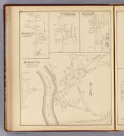
Full Title
Hillsborough Bridge P.O., town of Hillsborough, Hillsborough Co. (D.H. Hurd & Co., Boston. 1892)
List No
2023.090
Note
Lithographed map. Shows buildings, landowners, railroad, cemetery, etc.
Full Title
Hudson P.O., town of Hudson, Hillsborough County. (with) Merrimack P.O., town of Merrimack. (with) Thornton Ferry P.O., town of Merrimack. (with) Reeds Ferry P.O., town of Merrimack. (D.H. Hurd & Co., Boston. 1892)
List No
2023.091
Note
Lithographed map with 3 insets. Shows buildings, landowners, etc. Scale of insets 1:6,000.
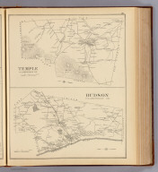
Full Title
Temple, Hillsborough Co. Hudson, Hillsborough Co. (D.H. Hurd & Co., Boston. 1892)
List No
2023.092
Note
Two lithographed maps. Show settlements, roads, railroad, landowners, etc. Relief shown by hachures. Hudson at 1:39,000 scale.
Full Title
Bennington, Hillsborough Co. (with) Windsor, Hillsborough Co. (D.H. Hurd & Co., Boston. 1892)
List No
2023.093
Note
Lithographed map with inset. Shows settlements, railroads, landowners, etc.
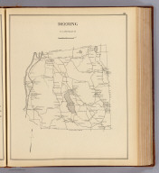
Full Title
Deering, Hillsborough Co. (D.H. Hurd & Co., Boston. 1892)
List No
2023.094
Note
Lithographed map. Shows settlements, roads, railroad, landowners, etc.
Full Title
Cheshire County, N.H. (D.H. Hurd & Co., Boston. 1892)
List No
2023.095
Note
Hand colored map. Shows settlements, towns, railroads, population, valuation, etc. Relief shown by hachures.
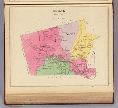
Full Title
Keene, Cheshire Co. (D.H. Hurd & Co., Boston. 1892)
List No
2023.096
Note
Hand colored map. Shows wards, streets and roads, railroads, landowners, etc.
Full Title
Part of Keene, Cheshire Co., N.H. Part of Ward 1. (D.H. Hurd & Co., Boston. 1892)
List No
2023.097
Note
Hand colored map. Shows buildings color coded as business blocks or residences, ward boundaries and railroads.
Full Title
Part of Keene, Cheshire Co., N.H. Ward 1. (with) Part of Ward 2. (D.H. Hurd & Co., Boston. 1892)
List No
2023.098
Note
Hand colored map with inset. Shows buildings color coded as business blocks or residences, ward boundaries and railroads.
Full Title
Part of Keene, Cheshire Co., N.H. Part of Ward 2. (D.H. Hurd & Co., Boston. 1892)
List No
2023.099
Note
Hand colored map with inset. Shows buildings color coded as business blocks or residences, ward boundaries and railroads. Includes Greenlawn Cemetery and City Hall.
Full Title
Part of Keene, Cheshire Co., N.H. Ward Three. (with) Part of Ward 5. (D.H. Hurd & Co., Boston. 1892)
List No
2023.100
Note
Hand colored map with inset. Shows buildings color coded as business blocks or residences, ward boundaries and railroads. Includes Museum Block, Clark Block, 1st and 2nd Congregational churches and Bethany Church.
Full Title
Part of Keene, Cheshire Co., N.H. Part of Ward 4. (D.H. Hurd & Co., Boston. 1892)
List No
2023.101
Note
Hand colored map with inset. Shows buildings color coded as business blocks or residences, ward boundaries and railroads. Includes the Armory and Court House.
Full Title
Part of Keene, Cheshire Co., N.H. Part of Ward 5. (D.H. Hurd & Co., Boston. 1892)
List No
2023.102
Note
Hand colored map with inset. Shows buildings color coded as business blocks or residences, ward boundaries and railroads. Includes F.R.R. shops and round house, City Hotel and St. Bernard's Church.
Full Title
Swanzey, Cheshire Co. Surry, Cheshire Co. Hinsdale, Cheshire Co. West Swanzey P.O., town of Swanzey, Cheshire Co. (with) East Swanzey P.O., Cheshire Co. (with) Westport P.O., town of Swanzey, Cheshire Co. (D.H. Hurd & Co., Boston. 1892)
List No
2023.103
Note
Four lithographed maps with 2 insets. Show settlements, railroads, landowners, buildings, etc. Relief shown by hachures.
Full Title
Hinsdale P.O., town of Hinsdale, Cheshire Co. (D.H. Hurd & Co., Boston. 1892)
List No
2023.104
Note
Lithographed map. Shows buildings, streets, railroad, landowners, etc.
Full Title
Richmond, Cheshire Co. (D.H. Hurd & Co., Boston. 1892)
List No
2023.105
Note
Lithographed map. Shows settlements, roads, landowners, etc.
Full Title
Winchester, Cheshire County. Winchester P.O., town of Winchester. (with) Ashuelot, town of Winchester. (with) Lower Ashuelot, town of Winchester. (D.H. Hurd & Co., Boston. 1892)
List No
2023.106
Note
Two lithographed maps with 2 insets. Show settlements, roads, streets, railroads, buildings, landowners, etc. Relief shown by hachures. Scale of Winchester P.O. not given.
Full Title
Troy, Cheshire Co. Troy P.O., town of Troy, Cheshire County. Marlborough, Cheshire Co. (D.H. Hurd & Co., Boston. 1892)
List No
2023.107
Note
Three lithographed maps. Show settlements, buildings, roads, streets, railroads, landowners, etc.
Full Title
Marlborough P.O., town of Marlborough, Cheshire Co. (D.H. Hurd & Co., Boston. 1892)
List No
2023.108
Note
Lithographed map. Shows streets, railroad, buildings, landowners, etc.
Full Title
Westmoreland, Cheshire Co. Gilsum, Cheshire Co. (with) Park Hill P.O., town of Westmoreland P.O. (sic). (D.H. Hurd & Co., Boston. 1892)
List No
2023.109
Note
Two lithographed maps. Show settlements, railroad, landowners, etc. Gilsum at 1:43,000 scale.
Full Title
Walpole P.O., town of Walpole, Cheshire Co. (with) North Walpole, town of Walpole, Cheshire Co. (with) Gilsum P.O., town of Gilsum, Cheshire Co. (D.H. Hurd & Co., Boston. 1892)
List No
2023.110
Note
Lithographed map with 2 insets. Shows settlements, railroad, landowners, etc. Gilsum P.O. at 1:5,400 scale.
Full Title
Walpole, Cheshire Co. Sullivan and Roxbury, Cheshire Co. (D.H. Hurd & Co., Boston. 1892)
List No
2023.111
Note
Two lithographed maps. Show settlements, railroad, landowners, etc. Relief shown by hachures.
Full Title
Chesterfield, Cheshire Co. (with) Chesterfield Factory P.O., town of Chesterfield. (with) Chesterfield P.O., town of Chesterfield. (D.H. Hurd & Co., Boston. 1892)
List No
2023.112
Note
Lithographed map with 2 insets. Shows settlements, landowners, etc. Relief shown by hachures. Chesterfield Factory P.O. is now called Spofford.
Full Title
Nelson, Cheshire Co. Rindge, Cheshire Co. (D.H. Hurd & Co., Boston. 1892)
List No
2023.113
Note
Two lithographed maps. Show settlements, railroad, landowners, etc. Relief shown by hachures. Rindge is at 1:46,000 scale.
Full Title
Marlow, Cheshire Co. (with) Rindge, town of Rindge. (with) Marlow P.O., Cheshire Co. (with) Munsonville P.O., town of Nelson. (D.H. Hurd & Co., Boston. 1892)
List No
2023.114
Note
Lithographed map with 3 insets. Shows settlements, landowners, etc.
Full Title
Alstead, Cheshire Co. (with) Alstead P.O., town of Alstead. (D.H. Hurd & Co., Boston. 1892)
List No
2023.115
Note
Lithographed map with inset. Shows settlements, landowners, etc.
Full Title
Fitzwilliam, Cheshire Co. (with) Fitzwilliam Village, town of Fitzwilliam. (with) Fitzwilliam Depot P.O., town of Fitzwilliam. (D.H. Hurd & Co., Boston. 1892)
List No
2023.116
Note
Lithographed map with 2 insets. Shows settlements, railroad, landowners, etc.
Full Title
Stoddard, Cheshire Co. (with) Stoddard P.O., town of Stoddard, Cheshire Co. (and Mill Village. D.H. Hurd & Co., Boston. 1892)
List No
2023.117
Note
Lithographed map with inset. Shows settlements, landowners, etc.
Full Title
Dublin, Harrisville, Cheshire Co. Harrisville P.O., town of Harrisville. (D.H. Hurd & Co., Boston. 1892)
List No
2023.118
Note
Two lithographed maps. Show settlements, railroads, landowners, buildings. Relief shown by hachures. Harrisville P.O. at 1:4,800 scale.
Full Title
Jaffrey, Cheshire Co. (with) East Jaffrey P.O., town of Jaffrey, Cheshire Co. (with) Jaffrey Center P.O., town of Jaffrey. (D.H. Hurd & Co., Boston. 1892)
List No
2023.119
Note
Lithographed map with 2 insets. Shows settlements, railroad, landowners, etc. Relief shown by hachures. East Jaffrey P.O. is now Jaffrey.
Full Title
Sullivan County. (D.H. Hurd & Co., Boston. 1892)
List No
2023.120
Note
Hand colored map. Shows settlements, towns, railroads, population, valuation, etc. Relief shown by hachures.
Full Title
Newport, Sullivan Co. (with) N. Newport P.O., town of Newport, Sullivan Co. (D.H. Hurd & Co., Boston. 1892)
List No
2023.121
Note
Lithographed map with inset. Shows settlements, railroad, landowners, etc. Relief shown by hachures.
Full Title
Newport, town of Newport, Sullivan Co. (with) Unity P.O., town of Unity, Sullivan Co. (D.H. Hurd & Co., Boston. 1892)
List No
2023.122
Note
Lithographed map with inset. Shows streets, railroad, buildings, landowners, etc.
Full Title
Plainfield, Sullivan County. Unity, Sullivan Co. (D.H. Hurd & Co., Boston. 1892)
List No
2023.123
Note
Two lithographed maps. Show settlements, landowners, etc. Relief shown by hachures. Unity at 1:48,000 scale.
Author
Greaves, H.
Full Title
Highland View, residence of Wm. H. Moody, Esq., Claremont, N.H. H. Greaves, 1892. (D.H. Hurd & Co., Boston)
List No
2023.124
Note
Two black and white illustrations showing house, barns, trees, etc.
Full Title
Center part of Claremont P.O., town of Claremont, Sullivan Co. (with) Meriden P.O., town of Plainfield, Sullivan Co. (with) Plainfield P.O., town of Plainfield, Sullivan Co. (with) East Plainfield P.O., town of Plainfield, Sullivan Co. (with) Quaker City P.O., town of Unity. (D.H. Hurd & Co., Boston. 1892)
List No
2023.125
Note
Lithographed map. Shows buildings shaded as public buildings or business blocks and residences, landowners, etc.
Full Title
Claremont P.O., town of Claremont, Sullivan Co. (with) Claremont, Sullivan Co. (with) The Plains, town of Claremont, Sullivan Co. (with) West Claremont P.O., Claremont, Sullivan Co. (D.H. Hurd & Co., Boston. 1892)
List No
2023.126
Note
Lithographed map. Shows buildings shaded as public buildings or business blocks and residences, landowners, etc.
Full Title
Sunapee, Sullivan Co. (with) Georges Mills P.O., Sunapee, Sullivan Co. (with) Lake View, town of Sunapee, Sullivan Co. (with) Sunapee Harbor, Sullivan County. (D.H. Hurd & Co., Boston. 1892)
List No
2023.127
Note
Lithographed map with 3 insets. Shows settlements, railroad, landowners, etc. Relief shown by hachures.
Author
[D.H. Hurd & Co., Greaves, H.]
Full Title
"Cupola Farm," P.M. Rossiter Esq., Claremont Junction, New Hampshire. H. Greaves, del. D.H. Hurd & Co., Boston (1892)
List No
2023.128
Note
Black and white illustration showing residence, barn and grounds.
Full Title
Croydon, Sullivan Co. (with) Croydon Flat P.O., town of Croydon. (with) Croydon P.O., town of Croydon. (D.H. Hurd & Co., Boston. 1892)
List No
2023.129
Note
Lithographed map with 2 insets. Shows settlements, roads, landowners, etc. Relief shown by hachures.
Full Title
Charlestown and Langdon, Sullivan County. (with) Charlestown P.O., town of Charleston, Sullivan County. (with) S. Charlestown P.O., town of Charlestown. (with) N. Charlestown P.O., town of Charlestown. (with) Langdon P.O., town of Langdon. (D.H. Hurd & Co., Boston. 1892)
List No
2023.130
Note
Lithographed map with 4 insets. Shows settlements, railroads, roads, landowners, etc. Relief shown by hachures.
Full Title
Acworth, Sullivan County. (with) Acworth P.O., town of Ackworth. (with) S. Acworth P.O., town of Ackworth. (D.H. Hurd & Co., Boston. 1892)
List No
2023.131
Note
Lithographed map with 2 insets. Shows settlements, roads, landowners, etc. Relief shown by hachures.
Full Title
Springfield, Sullivan Co. (with) W. Springfield P.O. (with) Keyes P.O., town of Lempster, Sullivan County (and) Lempster P.O., town of Lempster. (D.H. Hurd & Co., Boston. 1892)
List No
2023.132
Note
Lithographed map with 2 insets. Shows settlements, roads, landowners, etc. Relief shown by hachures.
Full Title
Lempster, Sullivan Co. Washington, Sullivan Co. Goshen, Sullivan Co. (with) E. Washington P.O., town of Washington. (with) E. Lempster P.O. (with) Washington P.O., town of Washington. (D.H. Hurd & Co., Boston. 1892)
List No
2023.133
Note
Three lithographed maps with 3 insets. Show settlements, roads, landowners, etc. Relief shown by hachures.
Full Title
Grantham, Sullivan Co. (with) Grantham P.O., town of Grantham. (D.H. Hurd & Co., Boston. 1892)
List No
2023.134
Note
Lithographed map with inset. Shows settlements, roads, landowners, etc.
Full Title
Cornish, Sullivan Co. (with) Cornish Flat P.O., town of Cornish. (D.H. Hurd & Co., Boston. 1892)
List No
2023.135
Note
Lithographed map with inset. Shows settlements, roads, railroad, landowners, etc. Relief shown by hachures.
Full Title
Rockingham County, N.H. (D.H. Hurd & Co., Boston. 1892)
List No
2023.136
Note
Hand colored lithographed map. Shows settlements, railroads, population, valuation, etc. Includes inset.
Full Title
Portsmouth, Rockingham Co. Part of the city of Portsmouth. (D.H. Hurd & Co., Boston. 1892)
List No
2023.137
Note
Two lithographed maps. City of Portsmouth map is hand colored and is at 1:2,400 scale, not "100 roads = 1 inch" as stated on map. Show settlements, roads, railroads landowners, buildings color coded as business blocks or residences.
Full Title
Part of the city of Portsmouth. (D.H. Hurd & Co., Boston. 1892)
List No
2023.138
Note
Hand colored map. Shows buildings color coded as business blocks or residences, etc.
Author
[D.H. Hurd & Co., Greaves, H.]
Full Title
"The Oceanic," Star Island, Isles of Shoals, N.H., Laighton Bros., proprietors. Appledore House, Appledore Island, Isles of Shoals, Laighton Brothers. H. Greaves 1892. D.H. Hurd & Co., Boston.
List No
2023.139
Note
Two black and white illustrations showing buildings, shore, boats, etc.
Full Title
Part of the city of Portsmouth. (D.H. Hurd & Co., Boston. 1892)
List No
2023.140
Note
Hand colored map. Shows buildings color coded as business blocks or residences, etc. Includes Goodwin Park and Haymarket Square.
Full Title
Part of the city of Portsmouth. (D.H. Hurd & Co., Boston. 1892)
List No
2023.141
Note
Hand colored map. Shows buildings color coded as business blocks or residences, etc. Includes Market Square, Union Wharf, Shea's Wharf, Russells Wharf and Long Wharf.
Full Title
Part of the city of Portsmouth. (D.H. Hurd & Co., Boston. 1892)
List No
2023.142
Note
Hand colored map. Shows buildings color coded as business blocks or residences, etc. Includes Union Rail Road Station and Noble Island.
Full Title
Part of the city of Portsmouth. (D.H. Hurd & Co., Boston. 1892)
List No
2023.143
Note
Hand colored map. Shows buildings color coded as business blocks or residences, etc. Includes North Mill Pond, Eldredges Brewery and Frank Jones Brewery Co.
Full Title
Part of the city of Portsmouth. (D.H. Hurd & Co., Boston. 1892)
List No
2023.144
Note
Hand colored map. Shows buildings color coded as business blocks or residences, etc. Includes North Mill Pond and City Farm.
Full Title
Exeter P.O., town of Exeter. (with) Exeter, Rockingham Co. (D.H. Hurd & Co., Boston. 1892)
List No
2023.145
Note
Lithographed map with inset. Shows buildings shaded as public buildings or business blocks and residences, owners, etc.
Full Title
Plaistow, Rockingham Co. (with) Plaistow P.O., town of Plaistow. (D.H. Hurd & Co., Boston. 1892)
List No
2023.146
Note
Lithographed map with inset. Shows settlements, roads, railroad, landowners, etc.
Author
[D.H. Hurd & Co., Poole, A. F.]
Full Title
Phillips Exeter Academy. Bert Poole, 1892. D.H. Hurd & Co., Boston.
List No
2023.147
Note
Black and white illustration showing buildings, grounds, students and bicycles.
Full Title
Salem, Rockingham Co. (with) Salem Village, Town of Salem. (with) Salem Depot, town of Salem. (D.H. Hurd & Co., Boston. 1892)
List No
2023.148
Note
Lithographed map with 2 insets. Shows settlements, roads, railroad, landowners, etc.
Full Title
East Kingston ... Danville ... Hampstead ... (all) Rockingham County. (D.H. Hurd & Co., Boston. 1892)
List No
2023.149
Note
Three lithographed maps. Show settlements, roads, railroad, landowners, etc.
Full Title
Sandown, Rockingham Co. (D.H. Hurd & Co., Boston. 1892)
List No
2023.150
Note
Lithographed map. Shows settlements, roads, railroad, landowners, etc.
Full Title
Deerfield, Rockingham Co. (D.H. Hurd & Co., Boston. 1892)
List No
2023.151
Note
Lithographed map. Shows settlements, roads, landowners, etc.
Full Title
Candia, Rockingham County. Epping, Rockingham County. (with) Candia P.O., town of Candia. (with) Chester, Rockingham County. (with) Chester Village, town of Chester. (D.H. Hurd & Co., Boston. 1892)
List No
2023.152
Note
Two lithographed maps with 3 insets. Show settlements, roads, railroads, landowners, etc. Epping at 1:34,000 scale.
Full Title
Fremont, Rockingham Co. Epping Village & P.O., town of Epping. (D.H. Hurd & Co., Boston. 1892)
List No
2023.153
Note
Two lithographed maps. Show settlements, roads, railroad, landowners, buildings, Spruce Swamp, etc. Epping Village at 1:4,500 scale.
Full Title
Hampton Falls, Rockingham County. Auburn, Rockingham Co. (D.H. Hurd & Co., Boston. 1892)
List No
2023.154
Note
Two lithographed maps. Show settlements, roads, railroads, landowners, etc. Relief shown by hachures. Auburn at 1:40,000 scale.
Full Title
Raymond, Rockingham County. (with) Raymond P.O., town of Raymond. (with) Massabesic, town of Auburn, Rockingham Co. (D.H. Hurd & Co., Boston. 1892)
List No
2023.155
Note
Lithographed map with 2 insets. Shows settlements, roads, railroad, landowners, etc.
Full Title
South Hampton, Rockingham Co. Atkinson, Rockingham Co. (D.H. Hurd & Co., Boston. 1892)
List No
2023.156
Note
Two lithographed maps. Show settlements, roads, railroad, landowners, etc. Atkinson map at 1:29,000 scale.
Full Title
Kingston, Rockingham Co. Kingston P.O., town of Kingston, Rockingham Co. (D.H. Hurd & Co., Boston. 1892)
List No
2023.157
Note
Two lithographed maps. Show settlements, roads, streets, railroad, landowners, buildings, etc. Scale of Kingston P.O. not given.
Full Title
Derry Depot P.O., town of Derry, Rockingham Co. (D.H. Hurd & Co., Boston. 1892)
List No
2023.158
Note
Lithographed map. Shows streets, railroad, landowners, etc.
Full Title
Derry, Rockingham Co. Seabrook, Rockingham Co. Rye, Rockingham Co. (with) Star Island, Gosport Ward, town of Rye. (D.H. Hurd & Co., Boston. 1892)
List No
2023.159
Note
Three lithographed maps with inset. Show settlements, roads, railroads, landowners, etc.
Full Title
Kensington, Rockingham Co. (with) East Derry P.O., town of Derry, Rockingham County. (with) Derry P.O., town of Derry, Rockingham County. (D.H. Hurd & Co., Boston. 1892)
List No
2023.160
Note
Lithographed map with 2 insets. Shows settlements, roads, landowners, etc.
Full Title
Newington, Rockingham Co. Londonderry, Rockingham Co. (D.H. Hurd & Co., Boston. 1892)
List No
2023.161
Note
Two lithographed maps. Show settlements, roads, railroads, landowners, etc. Londonderry at 1:54,000 scale.
Full Title
North Hampton, Rockingham Co. Newton, Rockingham Co. (D.H. Hurd & Co., Boston. 1892)
List No
2023.162
Note
Two lithographed maps. Show settlements, roads, railroads, landowners, etc. Newton at 1:22,000 scale.
Full Title
Greenland, Rockingham Co. (with) Newton Village, town of Newton. (D.H. Hurd & Co., Boston. 1892)
List No
2023.163
Note
Lithographed map with inset. Shows settlements, roads, railroads, landowners, etc.
Full Title
Stratham, Rockingham Co. (D.H. Hurd & Co., Boston. 1892)
List No
2023.164
Note
Lithographed map. Shows settlements, roads, railroad, landowners, etc. Relief shown by hachures.
Full Title
Nottingham, Rockingham Co. (D.H. Hurd & Co., Boston. 1892)
List No
2023.165
Note
Lithographed map. Shows settlements, roads, landowners, etc.
Full Title
Newmarket, Rockingham Co. (with) South Newmarket, Rockingham Co. (with) South Newmarket P.O., town of South Newmarket, Rockingham Co. (with) Newmarket P.O., town of Newmarket. (with) Town of Newcastle, Rockingham Co. (D.H. Hurd & Co., Boston. 1892)
List No
2023.166
Note
Lithographed map with 4 insets. Shows settlements, roads, railroads, landowners, etc. South Newmarket P.O. changed name to Newfields by 1895.
Full Title
Windham, Rockingham Co. Newcastle Village, town of Newcastle. (D.H. Hurd & Co., Boston. 1892)
List No
2023.167
Note
Two lithographed maps. Show settlements, roads, streets, railroad, landowners, etc. Newcastle Village at ca. 1:4,300 scale. It is co-extensive with the town of New Castle.
Full Title
Northwood, Rockingham Co. (with) Northwood Narrows P.O., town of Northwood. (D.H. Hurd & Co., Boston. 1892)
List No
2023.168
Note
Lithographed map with inset. Shows settlements, roads, landowners, etc.
Full Title
Hampton, Rockingham Co. Hampton Beach, town of Hampton. (D.H. Hurd & Co., Boston. 1892)
List No
2023.169
Note
Two lithographed maps. Show settlements, roads, railroad, landowners, buildings shaded as public buildings/business blocks or residences, etc. Relief shown by hachures. Hampton Beach is at ca. 1:6,500 scale.
Full Title
Brentwood, Rockingham County. Hampton P.O., town of Hampton. (D.H. Hurd & Co., Boston. 1892)
List No
2023.170
Note
Two lithographed maps. Show settlements, roads, streets, railroad, landowners, etc. Hampton P.O. at ca. 1:11,500 scale.
Full Title
Grafton County, N.H. (D.H. Hurd & Co., Boston. 1892)
List No
2023.171
Note
Hand colored map. Shows settlements, towns, railroads, population, valuation, etc. Relief shown by hachures.
Full Title
Scythestone works of the Pike Manufacturing Co., Pike Station, N.H. (D.H. Hurd & Co., Boston. 1892)
List No
2023.172
Note
Six black and white illustrations: Pike Station, N.H., warehouse, boarding house & residence -- Quarry -- Interior of mill room at Evansville, Vt. showing process of sawing stones -- Mill at Pike Station, N.H. -- Vermont mill -- Grinding room at Pike Station, N.H. showing process of grinding stones. Inset drawing: Cutting stone.
Full Title
Haverhill, Grafton Co. (D.H. Hurd & Co., Boston. 1892)
List No
2023.173
Note
Lithographed map. Shows settlements, roads, railroads, landowners, etc. Relief shown by hachures.
Full Title
Woodsville P.O., town of Haverhill, Grafton Co. (with) Haverhill P.O., town of Haverhill, Grafton Co., N.H. (with) Plan of Pike Station, town of Haverhill, Grafton Co., N.H. (with) North Haverhill, town of Haverhill, Grafton Co., N.H. (with) Pike Station and quarries of Pike Mfg. Co. (D.H. Hurd & Co., Boston. 1892)
List No
2023.174
Note
Lithographed map with 4 insets. Shows buildings shaded to indicate public buildings/business blocks or residences, landowners, railroad, etc. "Approved by the Pike Mfg. Co. ..."
Full Title
Orange, Grafton Co. Alexandria, Grafton Co. (with) Alexandria P.O., town of Alexandria. (D.H. Hurd & Co., Boston. 1892)
List No
2023.175
Note
Two lithographed maps with inset. Show settlements, roads, railroad, landowners, etc. Relief shown by hachures. Alexandria is at ca. 1:52,000 scale; inset at ca. 1:11,900 scale.
Full Title
Canaan, Grafton Co. (with) Canaan Centre P.O., town of Canaan. (with) Canaan P.O., town of Canaan. (with) West Canaan P.O., town of Canaan. (D.H. Hurd & Co., Boston. 1892)
List No
2023.176
Note
Lithographed map with 3 insets. Shows settlements, roads, railroad, landowners, etc. Relief shown by hachures.
Full Title
Plymouth P.O., town of Plymouth. (with) Lyme, Grafton Co. (with) Plymouth, Grafton Co. (with) Lyme Center P.O., town of Lyme, Grafton Co. (with) Lyme P.O., town of Lyme, Grafton Co. (D.H. Hurd & Co., Boston. 1892)
List No
2023.177
Note
Lithographed map with 4 insets. Shows buildings shaded to indicate public/business blocks or residences, streets, railroad, bridge, landowners, etc.
Full Title
Orford, Grafton Co. (with) Orford P.O., town of Orford. (D.H. Hurd & Co., Boston. 1892)
List No
2023.178
Note
Lithographed map with inset. Shows settlements, roads, landowners, etc.
Full Title
Enfield P.O., Grafton Co. (D.H. Hurd & Co., Boston. 1892)
List No
2023.179
Note
Lithographed map. Shows buildings shaded to indicate public/business blocks or residences, landowners, railroad, etc.
Full Title
Lebanon P.O., town of Lebanon, Grafton Co. (with) Enfield, Grafton County. (with) Enfield Center P.O., town of Enfield. (with) Locke Haven, town of Enfield. (D.H. Hurd & Co., Boston. 1892)
List No
2023.180
Note
Lithographed map with 3 insets. Shows buildings shaded to indicate public/business blocks or residences, landowners, railroad, cemeteries, etc.
Full Title
Lebanon, Grafton Co. (D.H. Hurd & Co., Boston. 1892)
List No
2023.181
Note
Lithographed map. Shows settlements, roads, railroad, landowners, etc. Relief shown by hachures.
Full Title
West Lebanon P.O., town of Lebanon, Grafton Co. (D.H. Hurd & Co., Boston. 1892)
List No
2023.182
Note
Lithographed map. Shows buildings shaded to indicate public/business blocks or residences, landowners, railroad, etc.
Full Title
Monroe, Lyman & Bath, Grafton Co. (with) Monroe P.O. (D.H. Hurd & Co., Boston. 1892)
List No
2023.183
Note
Two lithographed maps with inset. Show settlements, roads, railroad, landowners, etc. Relief shown by hachures.
Full Title
Piermont, Grafton Co. (with) Swift Water P.O., town of Bath. (with) Bath P.O., town of Bath. (with) Piermont P.O., town of Piermont. (D.H. Hurd & Co., Boston. 1892)
List No
2023.184
Note
Lithographed map with 3 insets. Shows settlements, roads, landowners, etc. Relief shown by hachures.
Full Title
Franconia, Grafton Co. Lincoln, Grafton Co., Woodstock, Grafton Co. (D.H. Hurd & Co., Boston. 1892)
List No
2023.185
Note
Two lithographed maps. Show settlements, roads, railroads, landowners, etc. Relief shown by hachures. Scale of Lincoln and Woodstock ca. 1:73,000.
Author
[D.H. Hurd & Co., Poole, A. F.]
Full Title
Deer Park Hotel, North Woodstock, N.H. Bert Poole, 1892. D.H. Hurd & Co., Boston.
List No
2023.186
Note
Black and white drawing, surrounded by 7 auxiliary drawings. Show buildings, grounds, etc. Auxiliary drawings: (Cascade) -- Meeting of the rivers -- Bell's Cascade -- View looking south -- Looking north from hotel tower -- Agassiz Basin -- Georgiana Falls.
Full Title
Grafton, Grafton Co. (with) Franconia P.O., town of Franconia, Grafton Co. (with) Grafton P.O. (with) E. Grafton P.O., town of Grafton. (D.H. Hurd & Co., Boston. 1892)
List No
2023.187
Note
Lithographed map with 3 insets. Shows settlements, roads, railroad, landowners, etc. Relief shown by hachures.
Full Title
Waterville, Grafton Co. Thornton, Grafton Co. (D.H. Hurd & Co., Boston. 1892)
List No
2023.188
Note
Two lithographed maps. Show settlements, roads, landowners, etc. Thornton at 1:70,000 scale. Relief shown by hachures.
Full Title
Ellsworth and Rumney, Grafton Co. (with) Rumney P.O., town of Rumney, Grafton Co. (D.H. Hurd & Co., Boston. 1892)
List No
2023.189
Note
Lithographed map with inset. Shows settlements, roads, railroad, landowners, etc. Relief shown by hachures.
Full Title
Landaff, Grafton Co., Easton, Grafton Co. Bristol, Grafton Co. (D.H. Hurd & Co., Boston. 1892)
List No
2023.190
Note
Two lithographed maps. Show settlements, roads, landowners, etc. Bristol is at 1:45,000 scale. Relief shown by hachures.
Full Title
Bristol P.O., town of Bristol, Grafton Co., N.H. (D.H. Hurd & Co., Boston. 1892)
List No
2023.191
Note
Lithographed map. Shows buildings shaded to indicate public/business blocks or residences, landowners, railroad, etc.
Full Title
Bridgewater, Grafton Co. Hebron, Grafton Co. (with) Hebron P.O., town of Hebron. (D.H. Hurd & Co., Boston. 1892)
List No
2023.192
Note
Two lithographed maps with inset. Show settlements, roads, railroad, landowners, etc. Hebron Town at 1:36,000 scale. Relief shown by hachures.
Full Title
Warren, Grafton Co. (with) Ashland, Grafton County. (with) Ashland P.O., town of Ashland. (with) Warren P.O., town of Warren. (D.H. Hurd & Co., Boston. 1892)
List No
2023.193
Note
Lithographed map with 3 insets. Shows settlements, roads, railroad, landowners, etc. Relief shown by hachures.
Full Title
Wentworth, Grafton Co. (with) Wentworth P.O., town of Wentworth. (D.H. Hurd & Co., Boston. 1892)
List No
2023.194
Note
Lithographed map with inset. Shows settlements, roads, railroad, landowners, etc. Relief shown by hachures.
Author
[D.H. Hurd & Co., Greaves, H.]
Full Title
Hotel Lookoff, Sugar Hill, N.H. Hiram Noyes & Sons, proprietors. H. Greaves del. D.H. Hurd & Co., Boston (1892)
List No
2023.195
Note
Black and white drawing showing building, grounds, coach, etc. Ancillary drawings: White Mountains from Hotel Lookoff -- The dairy farm -- Mineral springs & bowling alley looking towards Mt. Lafayette.
Full Title
Campton, Grafton Co. Holderness, Grafton Co. (with) Campton Village P.O., town of Campton. (D.H. Hurd & Co., Boston. 1892)
List No
2023.196
Note
Two lithographed maps with inset. Show settlements, roads, railroad, landowners, etc. Relief shown by hachures.
Full Title
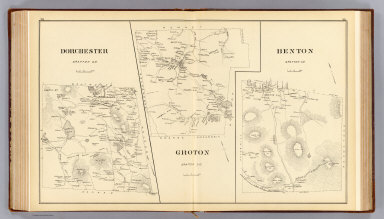
Dorchester, Grafton Co. Groton, Grafton Co. Benton, Grafton Co. (D.H. Hurd & Co., Boston. 1892)
List No
2023.197
Note
Three lithographed maps. Show settlements, roads, railroad, landowners, etc. Relief shown by hachures.
Full Title
Hanover, Grafton Co. (with) Livermore, Grafton Co. (with) Etna P.O. (D.H. Hurd & Co., Boston. 1892)
List No
2023.198
Note
Lithographed map with 2 insets. Shows settlements, roads, landowners, etc. Relief shown by hachures.
Author
Greaves, H.
Full Title
Sunset Hill House, Sugar Hill, N.H. Bowles & Hoskins (proprietors). H.E. Greaves, 1892. (D.H. Hurd & Co., Boston)
List No
2023.199
Note
Black and white drawing showing building, grounds, etc. Ancillary drawings: Mt. Lafayette from Sunset Hill House -- Looking west from Sunset Hill house -- Pearl Lake -- "Lovers Lane" -- Bridal Veil Falls -- The annex -- Looking north from Sunset Hill House -- Mt. Washington from Sunset Hill House.
Full Title
Hanover P.O., town of Hanover, Grafton Co. (D.H. Hurd & Co., Boston. 1892)
List No
2023.200
Note
Lithographed map. Shows buildings shaded to indicate public/business blocks or residences, landowners, cemetery, Dartmouth College, New Hampshire Agricultural College Farm, etc.
Full Title
Bethlehem, Grafton Co. Bethlehem P.O. ... Maplewood P.O., town of Bethlehem, Grafton Co. (D.H. Hurd & Co., Boston. 1892)
List No
2023.201
Note
Two lithographed maps. Show settlements, roads, streets, railroads, landowners, buildings etc. Relief shown by hachures. Bethlehem P.O., Maplewood P.O. at 1:6,400 scale.
Full Title
Lisbon, Grafton Co. (with) Sugar Hill P.O., town of Lisbon, Grafton Co. (D.H. Hurd & Co., Boston. 1892)
List No
2023.202
Note
Lithographed map with inset. Shows settlements, roads, railroad, landowners, etc. Relief shown by hachures.
Author
[D.H. Hurd & Co., Greaves, H.]
Full Title
Saranac Glove Works, Littleton, N.H. H. Greaves, del. D.H. Hurd & Co., Boston. Goodnow House, E.H. Goodnow & Co., proprietors, Sugar Hill, Franconia, N.H. H. Greaves, del. D.H. Hurd & Co., Boston. (1892)
List No
2023.203
Note
Two black and white drawings showing buildings and grounds. Insets: Residence of Ira Parker, Esq. -- View of Mt. Washington from Parker Mt. -- Mt. Washington -- Mt. Lafayette.
Full Title
Lisbon P.O., town of Lisbon. Littleton, Grafton County. (with) Pattenville P.O., town of Littleton. (with) Willowdale P.O., town of Littleton. (D.H. Hurd & Co., Boston. 1892)
List No
2023.204
Note
Two lithographed maps with 2 insets. Show buildings shaded to indicate public/business blocks or residences, settlements, roads, railroads, landowners, etc. Relief shown by hachures. Littleton scale 1:50,000.
Full Title
Littleton P.O., town of Littleton, Grafton Co. (D.H. Hurd & Co., Boston. 1892)
List No
2023.205
Note
Lithographed map. Shows buildings shaded to indicate public/business blocks or residences, landowners, railroad, etc.
Full Title
Strafford County, N.H. (D.H. Hurd & Co., Boston. 1892)
List No
2023.206
Note
Hand colored map. Shows settlements, towns, railroads, population, valuation, etc. Relief shown by hachures.
Full Title
City of Dover, Strafford Co. (D.H. Hurd & Co., Boston. 1892)
List No
2023.207
Note
Lithographed map. Shows settlements, roads, railroads, landowners, etc.
Full Title
Part of Dover. (D.H. Hurd & Co., Boston. 1892)
List No
2023.208
Note
Hand colored map. Shows buildings color coded as business blocks or residences, horse car and electric railroads, landowners, wards, etc. Relief shown by hachures.
Author
Myrick, Frank W.
Full Title
Plant of Somersworth Machine Co. at Dover, Great falls & Salmon falls, New Hampshire. O.S. Brown, President. E.H. Gilman, Treasurer. F. Myrick (del. D.H. Hurd & Co., Boston. 1892)
List No
2023.209
Note
Black and white drawing with 2 insets.
Full Title
Part of Dover. (D.H. Hurd & Co., Boston. 1892)
List No
2023.210
Note
Hand colored map. Shows buildings color coded as business blocks or residences, horse car and electric railroads, landowners, wards, etc. Covers part of Ward 2.
Full Title
Part of Dover. (D.H. Hurd & Co., Boston. 1892)
List No
2023.211
Note
Hand colored map. Shows buildings color coded as business blocks or residences, horse car and electric railroads, landowners, wards, etc. Covers part of Ward 4 including Pine Hill Cemetery and Tuttle Square.
Full Title
Part of Dover. (D.H. Hurd & Co., Boston. 1892)
List No
2023.212
Note
Hand colored map. Shows buildings color coded as business blocks or residences, horse car and electric railroads, landowners, wards, etc. Covers part of Ward 1.
Author
Poole, A. F.
Full Title
Sawyer Woolen Mills, Dover, N.H. Bert Poole. (D.H. Hurd & Co., Boston. 1892)
List No
2023.213
Note
Black and white drawing showing buildings, grounds, railroad and station, etc.
Full Title
Part of Dover. (D.H. Hurd & Co., Boston. 1892)
List No
2023.214
Note
Hand colored map. Shows buildings color coded as business blocks or residences, horse car and electric railroads, landowners, wards, etc. Covers part of wards 2-3. The name "Varney School" added in pencil.
Full Title
Part of Dover, part of Ward 4. (D.H. Hurd & Co., Boston. 1892)
List No
2023.215
Note
Hand colored map. Shows buildings color coded as business blocks or residences, horse car and electric railroads, landowners, wards, etc. Covers Catholic Cemetery, Sawyer's Mills, Sawyer's Rail Road Station and part of Pine Hill Cemetery.
Author
[D.H. Hurd & Co., Goist, P. F.]
Full Title
Cocheco Manufacturing Co., Dover, N.H. Lawrence & Co., selling agents. P.F. Goist del. D.H. Hurd & Co., Boston. (1892)
List No
2023.216
Note
Black and white drawing showing buildings, bridges, wagons, etc.
Full Title
City of Rochester, Strafford County. (D.H. Hurd & Co., Boston. 1892)
List No
2023.217
Note
Hand colored map. Shows settlements, roads, railroads, administrative subdivisions, landowners, etc.
Full Title
Part of Rochester, Strafford Co. (D.H. Hurd & Co., Boston. 1892)
List No
2023.218
Note
Hand colored map. Shows buildings color coded as business blocks or residences, ward boundaries, railroads, landowners, etc. Covers the Common, Old Cemetery and New Cemetery .
Full Title
Part of Rochester, Strafford Co. (D.H. Hurd & Co., Boston. 1892)
List No
2023.219
Note
Hand colored map. Shows buildings color coded as business blocks or residences, ward boundaries, railroads, landowners, etc. Covers part of fairgrounds.
Full Title
East Rochester P.O., part of Ward 1, city of Rochester, Strafford Co. (D.H. Hurd & Co., Boston. 1892)
List No
2023.220
Note
Hand colored map. Shows buildings color coded as business blocks or residences, landowners, railroad, etc. Covers Cocheco Woolen Mills.
Full Title
Farmington P.O., town of Farmington, Strafford Co. (D.H. Hurd & Co., Boston. 1892)
List No
2023.221
Note
Lithographed map. Shows buildings shaded as public/business blocks or residences, railroads, landowners, etc.
Full Title
Gonic P.O., part of Ward 3, city of Rochester, Strafford Co. (D.H. Hurd & Co., Boston. 1892)
List No
2023.222
Note
Lithographed map. Shows buildings shaded as public/business blocks or residences, railroads, landowners, etc.
Full Title
Farmington, Strafford Co. (D.H. Hurd & Co., Boston. 1892)
List No
2023.223
Note
Lithographed map. Shows settlements, roads, railroad, landowners, etc.
Full Title
New Durham, Strafford Co. (with) Madbury, Strafford County. (with) Lee, Strafford Co. (D.H. Hurd & Co., Boston. 1892)
List No
2023.224
Note
Lithographed map with 2 insets. Shows settlements, roads, railroad, landowners, etc. Relief shown by hachures.
Full Title
Rollinsford, Strafford Co. (D.H. Hurd & Co., Boston. 1892)
List No
2023.225
Note
Lithographed map. Shows settlements, roads, railroad, landowners, etc. Relief shown by hachures.
Full Title
Salmon Falls, P.O., town of Rollinsford, Strafford Co. (D.H. Hurd & Co., Boston. 1892)
List No
2023.226
Note
Lithographed map. Shows buildings shaded as public/business blocks or residences, railroads, landowners, etc.
Full Title
Milton, Strafford Co. (with) Middleton, Strafford Co. (with) Milton P.O., town of Milton, Strafford Co. (with) Milton Mills P.O., town of Milton, Strafford Co. (D.H. Hurd & Co., Boston. 1892)
List No
2023.227
Note
Lithographed map with 3 insets. Shows settlements, roads, railroad, landowners, etc. Relief shown by hachures.
Full Title
Barrington, Strafford Co. (D.H. Hurd & Co., Boston. 1892)
List No
2023.228
Note
Lithographed map. Shows settlements, roads, railroad, landowners, etc.
Full Title
Strafford, Strafford Co. (D.H. Hurd & Co., Boston. 1892)
List No
2023.229
Note
Lithographed map. Shows settlements, roads, landowners, etc.
Full Title
Great Falls, town of Somersworth, Stafford Co. (with) Somersworth, Strafford County. (D.H. Hurd & Co., Boston. 1892)
List No
2023.230
Note
Lithographed map with inset. Shows buildings shaded as public/business blocks or residences, railroads, landowners, etc. Scale of Somersworth map 1:31,000.
Full Title
Durham, Strafford Co. (with) Durham P.O. (D.H. Hurd & Co., Boston. 1892)
List No
2023.231
Note
Lithographed map with inset. Shows settlements, roads, railroad, landowners, etc.
Full Title
Belknap County, N.H. (D.H. Hurd & Co., Boston. 1892)
List No
2023.232
Note
Hand colored map. Shows settlements, towns, roads, railroads, population, valuations, etc. Relief shown by hachures.
Full Title
Village of Laconia, Belknap Co. (with) Central part of Laconia Village. (D.H. Hurd & Co., Boston. 1892)
List No
2023.233
Note
Lithographed map with 2 insets. Shows buildings shaded as public/business blocks or residences, railroad, landowners, etc. Second inset "Part of village of Laconia ..." is continuation of main map. Central part of Laconia at 1:2,200 scale.
Full Title
Laconia, Belknap County. (with) The Weirs, town of Laconia, Belknap Co. (D.H. Hurd & Co., Boston. 1892)
List No
2023.234
Note
Lithographed map with inset. Shows settlements, roads, railroad, landowners, etc.
Full Title
Laconia Car Company, manufacturers of railway cars of every description ... Laconia, N.H. Perley Putnam--Pres. ... (with) Residence of Perley Putnam. (D.H. Hurd & Co., Boston. 1892)
List No
2023.235
Note
Black and white drawing with inset. Shows buildings, trains, river, etc.
Full Title
Part of Laconia. (with) Gilmanton P.O., town of Gilmanton, Belknap Co., N.H. (with) Gilmanton Iron Works, town of Gilmanton, Belknap Co. (with) Part of Laconia. (D.H. Hurd & Co., Boston. 1892)
List No
2023.236
Note
Lithographed map with 3 insets. Shows buildings shaded as public/business blocks or residences, railroad, landowners, etc.
Full Title
Gilmanton, Belknap Co., N.H. (D.H. Hurd & Co., Boston. 1892)
List No
2023.237
Note
Lithographed map. Shows settlements, roads, landowners, etc.
Author
[D.H. Hurd & Co., Greaves, H.]
Full Title
Nestledown, Zebley Farm, Weirs, N.H. H. Greaves, del. 92. D.H. Hurd & Co., Boston.
List No
2023.238
Note
Two black and white drawings with 2 insets. One drawing and 2 insets have titles: Farm buildings & manager's house, F.S. Sumner, Mngr. -- West end of residence -- Nestledown Beach, Lake Winnipesaukee.
Full Title
Barnstead, Belknap Co. (with) Barnstead Centre, town of Barnstead, Belknap Co. (with) Barnstead Parade, town of Barnstead. (D.H. Hurd & Co., Boston. 1892)
List No
2023.239
Note
Lithographed map with 2 insets. Shows settlements, roads, railroad, landowners, etc.
Full Title
Meredith, Belknap Co., N.H. Meredith Village, town of Meredith, Belknap Co. (with) Southern part of Alton, Belknap Co., N.H. (with) Meredith Centre P.O., town of Meredith, Belknap Co. (D.H. Hurd & Co., Boston. 1892)
List No
2023.240
Note
Two lithographed maps with 2 insets. Show settlements, buildings shaded as public/business blocks or residences, roads, streets, landowners, etc. Meredith Village map at ca. 1:4,400.
Full Title
Northern part of Alton, Belknap, N.H. (D.H. Hurd & Co., Boston. 1892)
List No
2023.241
Note
Lithographed map. Shows settlements, roads, railroad, landowners, etc. Southern part on p. 260.
Full Title
Winnipiseogee House, Alton Bay, N.H. D.E. Wheeler, proprietor. Lakeside House, Weirs, N.H. Geo. W. Weeks, proprietor. (D.H. Hurd & Co., Boston. 1892)
List No
2023.242
Note
Two black and white drawings showing buildings, grounds, boats, carriages, etc. Ten insets including: Variety store & casino -- Depot looking south -- Profile Rock -- The Avenue.
Full Title
Alton P.O., town of Alton, Belknap Co., N.H. (D.H. Hurd & Co., Boston. 1892)
List No
2023.243
Note
Lithographed map. Shows buildings shaded as public/business blocks or residences, landowners, roads and streets, railroad, etc.
Full Title
New Hampton, Belknap Co. (with) Belmont, Belknap Co. (with) Belmont P.O., town of Belmont, Belknap Co. (with) New Hampton P.O., town of New Hampton, Belknap Co. (D.H. Hurd & Co., Boston. 1892)
List No
2023.244
Note
Lithographed map with 3 insets. Shows settlements, roads, railroad, landowners, etc. Relief shown by hachures.
Full Title
Gilford, Belknap Co. (with) Gilford P.O., town of Gilford, Belknap Co. (D.H. Hurd & Co., Boston. 1892)
List No
2023.245
Note
Lithographed map with inset. Shows settlements, roads, railroad, landowners, etc. Relief shown by hachures.
Full Title
Cole Manufacturing Company. Founders, machinists & forgers, Lakeport, N.H. B.J. Cole, Treas. H.B. Quinby, Supt. 1892. (with) Res. of B.J. Cole. (D.H. Hurd & Co., Boston. 1892)
List No
2023.246
Note
Black and white drawing with inset. Shows buildings, lake, wagons, etc.
Full Title
Lakeport, town of Guilford. (D.H. Hurd & Co., Boston. 1892)
List No
2023.247
Note
Lithographed map. Shows buildings shaded as public/business blocks or residences, railroad, landowners, etc. Includes inset.
Full Title
Tilton P.O., town of Tilton. Sanbornton and Tilton, Belknap Co. (with) East Tilton P.O., town of Tilton, Belknap Co. (with) Sanbornton P.O., town of Tilton, Belknap Co. (D.H. Hurd & Co., Boston. 1892)
List No
2023.248
Note
Two lithographed maps with 2 insets. Show buildings shaded as public/business blocks or residences, settlements, roads, railroad, landowners, etc. Relief shown by hachures. Scale of Sanbornton and Tilton map 1:42,000.
Full Title
Center Harbor P.O. Center Harbor, Belknap Co. (D.H. Hurd & Co., Boston. 1892)
List No
2023.249
Note
Two lithographed maps. Show buildings shaded as public/business blocks or residences, settlements, roads, railroad, landowners, etc. Relief shown by hachures. Center Harbor (Town) map at 1:30,000.
Full Title
Carroll County, N.H. (D.H. Hurd & Co., Boston. 1892)
List No
2023.250
Note
Hand colored map. Shows settlements, towns, railroads, population, valuations, etc. Relief shown by hachures.
Full Title
Ossipee, Carroll Co. (with) Moultonville P.O. ... (with) Ossipee P.O. ... (with) Water Village P.O. ... (with) Center Ossipee P.O. ... (with) Centerville P.O. ... (all) town of Ossipee, Carroll Co. (D.H. Hurd & Co., Boston. 1892)
List No
2023.251
Note
Lithographed map with 5 insets. Shows settlements, roads, railroad, landowners, etc. Relief shown by hachures.
Full Title
Sandwich, Carroll Co. (with) Sandwich P.O., town of Sandwich, Carroll Co. (D.H. Hurd & Co., Boston. 1892)
List No
2023.252
Note
Lithographed map with inset. Shows settlements, roads, railroads, landowners, etc. Bar scales switched on map and inset. Relief shown by hachures.
Full Title
Freedom, Carroll County. Tuftonborough, Carroll Co. (with) Melvin Village P.O., town of Tuftonborough. (D.H. Hurd & Co., Boston. 1892)
List No
2023.253
Note
Two lithographed maps with inset. Show settlements, roads, landowners, etc. Relief shown by hachures. Scale of Tuftonborough 1:62,000.
Author
[D.H. Hurd & Co., Whinnery, H. P.]
Full Title
Wentworth Hall and Cottages, Jackson, N.H. Gen. M.C. Wentworth, proprietor. Drawn by Whinnery. D.H. Hurd & Co., Boston, Mass. (1892)
List No
2023.254
Note
Black and white drawing showing buildings and grounds. Insets: Residence of General and Mrs. Wentworth -- Wentworth Hall -- Jackson Falls -- The Casino -- Glen Thorne -- View from residence.
Full Title
Jackson, Carroll Co. (with) Freedom P.O., town of Freedom, Carroll County. (with) Part of Jackson P.O., town of Jackson. (D.H. Hurd & Co., Boston. 1892)
List No
2023.255
Note
Lithographed map with 2 insets. Shows settlements, roads, landowners, etc. Relief shown by hachures.
Full Title
Conway, Carroll Co. N. Conway P.O., town of Conway, Carroll Co. (with) Centre Conway P.O., town of Conway. (with) Conway P.O., town of Conway, Carroll Co. (D.H. Hurd & Co., Boston. 1892)
List No
2023.256
Note
Two lithographed maps with 2 insets. Show settlements, buildings, roads, railroads, landowners, etc. Relief shown by hachures. Scale of N. Conway P.O. is 1:5,940.
Full Title
Madison, Carroll Co. Effingham, Carroll Co. (with) Effingham Falls P.O., town of Effingham & Freedom, Carroll County. (with) Drake's Corner, town of Effingham, Carroll County. (D.H. Hurd & Co., Boston. 1892)
List No
2023.257
Note
Two lithographed maps with 2 insets. Show settlements, roads, railroads, landowners, etc. Relief shown by hachures.
Author
Greaves, H.
Full Title
Iron Mountain House, Jackson, N.H., W.A. Meserve, proprietor. (with) Russell Cottages, Kearsarge Village, North Conway, N.H. (with) Country seat of Payson Tucker, Sunset Hill, North Conway, N.H. H.E. Greaves, 1891. (D.H. Hurd & Co., Boston. 1892)
List No
2023.258
Note
Black and white drawing with 2 ancillary views. Includes "Mt. Washington from Iron Mt. House" and another view.
Full Title
Bartlett, Carroll Co. Albany, Carroll Co. (D.H. Hurd & Co., Boston. 1892)
List No
2023.259
Note
Two lithographed maps. Show settlements, roads, railroad, landowners, etc. Relief shown by hachures. Albany scale is 1:72,000.
Full Title
Wolfeborough, Carroll Co. Wolfeborough P.O., town of Wolfeborough, Carroll Co., N.H. (with) Bartlett P.O., town of Bartlett. (with) Wolfeborough Junction P.O., town of Wakefield, Carroll Co. (with) Union P.O., town of Wakefield, Carroll County. (with) Wakefield P.O., town of Wakefield. (D.H. Hurd & Co., Boston. 1892)
List No
2023.260
Note
Two lithographed maps with 4 insets. Show settlements, roads, railroads, landowners, etc. Relief shown by hachures. Wolfeborough P.O. is at 1:4,100 scale.
Full Title
Moultonborough, Carroll County. (with) Wakefield, Carroll County. (D.H. Hurd & Co., Boston. 1892)
List No
2023.261
Note
Lithographed map with inset. Shows settlements, roads, landowners, etc. Relief shown by hachures.
Full Title
Tamworth, Carroll Co. (with) Chatham, Carroll County. (D.H. Hurd & Co., Boston. 1892)
List No
2023.262
Note
Lithographed map with inset. Shows settlements, roads, railroad, landowners, etc. Relief shown by hachures.
Full Title
Eaton, Carroll Co. Brookfield, Carroll Co. (D.H. Hurd & Co., Boston. 1892)
List No
2023.263
Note
Two lithographed maps. Show settlements, roads, railroad, landowners, etc. Relief shown by hachures. Brookfield is at 1:46,000 scale.
Full Title
Coos County, N.H. (D.H. Hurd & Co., Boston. 1892)
List No
2023.264
Note
Hand colored map. Shows settlements, towns, grants, railroads, population, valuations, etc. Relief shown by hachures.
Full Title
Colebrook, Coos Co. (with) Whitefield P.O., town of Whitefield, Coos Co. (with) Colebrook P.O., town of Colebrook, Coos Co. (D.H. Hurd & Co., Boston. 1892)
List No
2023.265
Note
Lithographed map with 2 insets. Shows settlements, roads, railroad, landowners, etc.
Full Title
Lancaster, town of Lancaster. (D.H. Hurd & Co., Boston. 1892)
List No
2023.266
Note
Lithographed map. Shows buildings shaded as public/business blocks or residences, landowners, railroads, etc.
Full Title
Berlin Falls P.O., town of Berlin, Berlin Mills P.O., town of Berlin. (with) Lancaster, Coos Co. (with Danville, Dix's Grant, Dartmouth College Grant, Wentworth Location, Coos County. D.H. Hurd & Co., Boston. 1892)
List No
2023.267
Note
Lithographed map with 2 insets. Shows buildings, landowners, railroad, etc.
Full Title
Clarksville, Coos Co., N.H. Berlin, Coos Co., N.H. (D.H. Hurd & Co., Boston. 1892)
List No
2023.268
Note
Two lithographed maps. Show settlements, roads, railroad, landowners, etc. Relief shown by hachures. Berlin map at 1:70,000 scale.
Author
Goist, P. F.
Full Title
Barron & Merrill's White Mountain houses, N.H. (D.H. Hurd & Co., Boston. 1892)
List No
2023.269
Note
Fifteen black and white drawings. Contents: Crawford Notch -- White Mountain Range -- Ammonoosue Lake -- Crawford House from Elephant's Head -- Mount Washington Railway -- Crawford Notch from Crawford House -- Tip Top House, Summit House, Mt. Washington, N.H. -- Beecher's Cascade -- Rear court, Crawford House, P.F. Goist del -- Crawford House in 1829 -- Ammonoosue Falls -- Gibbs' Falls -- Mt. Pleasant House -- Fabyan House, White Mt., N.H. -- Twin Mountain House.
Full Title
Shelburne, Coos Co. (with) Milan, Coos Co. (with) Milan P.O., town of Milan, Coos Co. (D.H. Hurd & Co., Boston. 1892)
List No
2023.270
Note
Lithographed map with 2 insets. Shows settlements, roads, railroads, landowners, etc. Relief shown by hachures.
Full Title
Carroll, Coos Co. (with) White Mt. Region, Coos Co. & Hart's Location, Carroll Co. (with) West Stewarstown P.O., Stewartstown, Coos Co. (with) Dalton, Coos Co. (with) Stewartstown, Coos Co. (D.H. Hurd & Co., Boston. 1892)
List No
2023.271
Note
Lithographed map with 4 insets. Shows settlements, roads, railroads, landowners, etc. Relief shown by hachures.
Full Title
Gorham, Coos Co., N.H. Northumberland, Coos Co. (D.H. Hurd & Co., Boston. 1892)
List No
2023.272
Note
Two lithographed maps. Show settlements, roads, railroads, landowners, etc. Relief shown by hachures. Northumberland at 1:52,000 scale.
Author
[D.H. Hurd & Co., Greaves, H.]
Full Title
Mountain View House, Whitefield, N.H. H. Greaves 1892. D.H. Hurd & Co., Boston.
List No
2023.273
Note
Black and white drawing. Alternate title: Mountain View House, Whitefield, N.H., W.F. Dodge & Son. Inset: The White Mountains from Mountain View House.
Full Title
Gorham P.O., town of Gorham. (with) Groveton P.O., town of Northumberland, Coos Co. (with) Northumberland P.O., town of Northumberland, Coos Co. (D.H. Hurd & Co., Boston. 1892)
List No
2023.274
Note
Lithographed map with 2 insets. Shows buildings, railroad, landowners, etc.
Full Title
Pittsburg, Hubbard, Webster & Carlisle, Coos Co. (with) Jefferson, Coos Co. (D.H. Hurd & Co., Boston. 1892)
List No
2023.275
Note
Lithographed map with inset. Shows settlements, roads, landowners, etc. Relief shown by hachures.
Full Title
Whitefield, Coos Co. Stark, Coos Co. (with) Percy P.O., town of Stark, Coos Co. (with) Stark P.O., town of Stark, Coos Co. (D.H. Hurd & Co., Boston. 1892)
List No
2023.276
Note
Two lithographed maps. Show settlements, roads, railroads, landowners, etc. Relief shown by hachures. Stark at 1:69,000 scale.
Full Title
Overlook House. Levi Bowles & Son. Kimball Hill, 2000 ft. elevation, Whitefield, N.H. (D.H. Hurd & Co., Boston. 1892)
List No
2023.277
Note
Black and white drawing showing building, grounds, people and carriage. Insets: S.W. view, Green Mountains in distance -- Looking east, Mt. Washington in distance -- The valley looking N.E.
Full Title
Stratford, Coos Co. (with) Columbia, Coos Co. (with) Stratford P.O., town of Stratford, Coos County. (with) No. Stratford Station, town of Stratford, Coos Co. (D.H. Hurd & Co., Boston. 1892)
List No
2023.278
Note
Lithographed map with 3 insets. Shows settlements, roads, railroads, landowners, etc. Includes Ervin's Location. Relief shown by hachures.
Full Title
Odell, Millsfield, Dummer & Cambridge, Coos Co. (with) Success, Coos Co. (D.H. Hurd & Co., Boston. 1892)
List No
2023.279
Note
Lithographed map with inset. Shows settlements, roads, landowners, etc. Relief shown by hachures.
Full Title
Errol, Coos Co. (with) Randolph, Coos Co. (D.H. Hurd & Co., Boston. 1892)
List No
2023.280
Note
Lithographed map with inset. Shows settlements, roads, landowners, etc. Relief shown by hachures.
Author
Clark, Hosea B.
Full Title
New Hampshire State government. (with) New Hampshire political sub-divisions 1891-1892, congressional chart ... councilor chart ... senatorial chart. Designed and edited by Hosea B. Carter, actuary, Concord N.H. (D.H. Hurd & Co., Boston. 1892)
List No
2023.281
Note
Text page with 3 hand colored maps 19 x 22 cm. Shows congressional and state legislative election districts.
Author
Bradley, Abraham Junior
Full Title
Map of the United States, Exhibiting the Post-Roads, the situations, connexions and distances of the Post-Offices, Stage Roads, Counties & Principal Rivers By Abraham Bradley Junr. Entered ... 2nd day of June1804, by Abraham Bradley Junr. of the District of Columbia. (inset) Map Of North America. (1809)
List No
3043.000
Note
Third edition. Compared to the first edition of 1804 and the second of 1805, Illinois is added; about 25 towns are added to the western Connecticut Reserve (the Fire Lands) in northern Ohio; Township and Range lines are added in southern Indiana. Relief shown pictorially. Shows Indian tribes. Prime meridian: Washington. Without the case, dissected as issued, mounted on new linen.
Author
U.S. Geological Survey
Full Title
San Francisco and vicinity, California. From Geological Survey atlas sheets surveyed in 1892-1913.
List No
5742.000
Note
Covers San Francisco and San Pablo Bay areas. Relief shown by contours and spot heights. Shows wetlands, roads, streets, buildings, railroads, etc. Title in upper margin: Topography, California, San Francisco Bay and vicinity. "Culture revision of San Francisco, Oakland, Alameda, Berkeley, and Richmond in 1913-1914. R.B. Marshall, Chief Geographer. Owned by Michael Moore.
Author
Allardt, G. F.
Full Title
Map no. 3. Salt marsh and tide lands situate in the city and county of San Francisco. To be sold at public auction by order of the Board of Tide Land Commissioners by Talbert & Leet, auctioneers, at their sales rooms no. 526 California Street, San Francisco. Sale to commence Friday Nov. 26th, 1869. B.F. Washington, H.P. Coon, L.L Bullock, Wm. S. Byrne, Secretary, Tide Land Commissioners. G.F. Allardt, Surveyor & Chief Engineer. C.H. Baker Lith., S.F.
List No
3970.000
Note
Cadastral map showing drainage, block and lot numbers, railroads, wharves, etc. Covers area from China Basin to Islais Creek. One of a series of maps published between 1869 and 1873 showing tidelands to be sold by order of the Board of Tide Land Commissioners.
Author
Allardt, G. F.
Full Title
Sale map no. 12. Salt marsh and tide lands situate in the city and county of San Francisco, state of California. To be sold at public auction by order of the Board of Tide Land Commissioners ... at the sales rooms of Greenebaum & Co., auctioneers, nos. 115 & 117 Bush Street, San Francisco. Sale to commence Tuesday, March 4th, 1873. R.P. Johnson, Edgar Briggs, C.M. Stratton, Board of Tide Land Commissioners. J.M. Currier, Secretary. G.F. Allardt, Chief Engineer.
List No
3971.000
Note
Another tide lands sale map, this one showing two separate areas titled "Salt Marsh and Tide Lands at North Beach" and "Salt Marsh and Tide Lands Along Mission Creek and Mission Bay." Shows drainage, block and lot numbers, etc. Covers area bounded generally by Mission, 20th, Mississippi, and Channel Streets; covers area bounded by the Bay, Webster and Lombard Streets, and the Presidio. Cadastral maps. Scale of 2nd map 1:6,000.
Author
[Branner, John Casper, California. State Earthquake Investigation Commission, Gilbert, G. K., Lawson, Andrew C., Reid, Harry Fielding]
Full Title
(Covers to) Atlas of maps and seismograms accompanying the report of the State Earthquake Investigation Commission upon the California earthquake of April 18, 1906. Andrew C. Lawson, G.K. Gilbert, H.F. Reid, J.C. Branner, A.O. Leuschner, George Davidson, Charles Burckhalter, W.W. Campbell. Carnegie Institution of Washington. Washington, D.C. 1908. (seal) Carnegie Institution of Washington 1902.
List No
2130A
Note
Dark green cloth covered boards with the title embossed in gold on the front cover.
Author
[Branner, John Casper, California. State Earthquake Investigation Commission, Gilbert, G. K., Lawson, Andrew C., Reid, Harry Fielding]
Full Title
(Title Page to) Atlas of maps and seismograms accompanying the report of the State Earthquake Investigation Commission upon the California earthquake of April 18, 1906. Andrew C. Lawson, G.K. Gilbert, H.F. Reid, J.C. Branner, A.O. Leuschner, George Davidson, Charles Burckhalter, W.W. Campbell. Carnegie Institution of Washington. Washington, D.C. 1908. (seal) Carnegie Institution of Washington 1902.
List No
2130B
Note
This atlas accompanied several text volumes (David Rumsey Collection has reproductions) and was the most complete mapping of the great earthquake of 1906. Maps printed in full and partial color. Covers are dark green cloth covered boards with the title embossed in gold on the front cover.
Author
[Branner, John Casper, California. State Earthquake Investigation Commission, Gilbert, G. K., Lawson, Andrew C., Reid, Harry Fielding]
Full Title
(Contents to) Atlas of maps and seismograms accompanying the report of the State Earthquake Investigation Commission upon the California earthquake of April 18, 1906. Andrew C. Lawson, G.K. Gilbert, H.F. Reid, J.C. Branner, A.O. Leuschner, George Davidson, Charles Burckhalter, W.W. Campbell. Carnegie Institution of Washington. Washington, D.C. 1908. (seal) Carnegie Institution of Washington 1902.
List No
2130C
Note
Table of contents.
Author
California. State Earthquake Investigation Commission
Full Title
Geomorphic map of California and Nevada with portions of Oregon and Idaho showing the diastrophic character of the relief, the steep descent from the sub-continental shelf to the floor of the Pacific, and the more important known faults. Earthquake Investigation Commission. Drawn by M. Solem. A. Hoen & Co., Baltimore. (Carnegie Institution of Washington, 1908)
List No
2130.001
Note
Color. Relief shown by hachures; depths by bathymetric isolines. Shows railways, towns, counties and drainage.
Author
California. State Earthquake Investigation Commission
Full Title
Map of a portion of the coast of California showing the San Andreas Rift from Point Arena to Fort Ross and the trace of the fault of April 18, 1906. Earthquake Investigation Commission. Julius Bien & Co., N.Y. (Carnegie Institution of Washington. 1908)
List No
2130.002
Note
Color. Also shows settlements, townships and sections, roads and drainage. "Compiled from the official maps of Sonoma and Mendocino Counties."
Author
[California. State Earthquake Investigation Commission, Matthes, Francois E.]
Full Title
Detail map of a typical portion of the San Andreas Rift near Fort Ross, Sonoma County, California showing its geomorphic features and the trace of the fault by Francois E. Matthes. Earthquake Investigation Commission. A. Hoen & Co., Baltimore. (Carnegie Institution of Washington. 1908)
List No
2130.003
Note
Color. Contour interval 5 ft. Shows roads, trails, houses, fences, ponds, streams, marshes, etc. Inset: Index map.
Author
California. State Earthquake Investigation Commission
Full Title
Map of the region about San Francisco Bay showing the relation of the city of San Francisco to the San Andreas Rift, the fault of April 18, 1906 and the fault of October 21, 1868. Earthquake Investigation Commission. Julius Bien & Co., Lith., N.Y. (Carnegie Institution of Washington. 1908)
List No
2130.004
Note
Color. Relief shown by contours and spot heights; depths by soundings and isoline. "Topography by the C. and G. Survey and the U.S. Geological Survey."
Author
California. State Earthquake Investigation Commission
Full Title
Map of a portion of the Coast Ranges of California showing the San Andreas Rift. Earthquake Investigation Commission. Julius Bien & Co., Lith., N.Y. (Carnegie Institution of Washington. 1908)
List No
2130.005
Note
Color. Contour interval 500 ft. Shows settlements, railroads, etc.
Author
[California. State Earthquake Investigation Commission, U.S. Geological Survey]
Full Title
California, Mt. Pinos quadrangle of the U.S. Geological Survey showing the San Andreas Rift. Earthquake Investigation Commission. (Carnegie Institution of Washington. 1908)
List No
2130.006
Note
Color. 30-minute topographic quadrangle. Relief shown by contours and spot heights. Covers portions of Ventura, Kern and Santa Barbara counties.
Author
[California. State Earthquake Investigation Commission, U.S. Geological Survey]
Full Title
California, Tejon quadrangle of the U.S. Geological Survey showing the San Andreas Rift. Earthquake Investigation Commission. (Carnegie Institution of Washington. 1908)
List No
2130.007
Note
Color. 30-minute topographic quadrangle. Relief shown by contours and spot heights. Covers portions of Kern, Los Angeles and Ventura counties.
Author
[California. State Earthquake Investigation Commission, U.S. Geological Survey]
Full Title
California, Palmdale quadrangle of the U.S. Geological Survey showing the San Andreas Rift. Earthquake Investigation Commission. A. Hoen & Co., Baltimore. (Carnegie Institution of Washington. 1908)
List No
2130.008
Note
Color. 30-minute topographic quadrangle. Relief shown by contours and spot heights. Covers portions of Kern and Los Angeles counties.
Author
[California. State Earthquake Investigation Commission, U.S. Geological Survey]
Full Title
California, Rock Creek quadrangle of the U.S. Geological Survey showing the San Andreas Rift. Earthquake Investigation Commission. Andrew B. Graham Co., Lithographers, Washington, D.C. (Carnegie Institution of Washington. 1908)
List No
2130.009
Note
Color. 15-minute topographic quadrangle. Relief shown by contours and spot heights. In Los Angeles County.
Author
[California. State Earthquake Investigation Commission, U.S. Geological Survey]
Full Title
California, San Antonio quadrangle of the U.S. Geological Survey showing the San Andreas Rift. Earthquake Investigation Commission. Andrew B. Graham Co., Lithographers, Washington, D.C. (Carnegie Institution of Washington. 1908)
List No
2130.010
Note
Color. 15-minute topographic quadrangle. Relief shown by contours and spot heights. Covers portions of Los Angeles and San Bernardino counties.
Author
[California. State Earthquake Investigation Commission, U.S. Geological Survey]
Full Title
California, Hesperia quadrangle of the U.S. Geological Survey showing the San Andreas Rift. Earthquake Investigation Commission. Andrew B. Graham Co., Lithographers, Washington, D.C. (Carnegie Institution of Washington. 1908)
List No
2130.011
Note
Color. 15-minute topographic quadrangle. Relief shown by contours and spot heights. Covers portion of San Bernardino County.
Author
[California. State Earthquake Investigation Commission, U.S. Geological Survey]
Full Title
California, San Bernardino quadrangle of the U.S. Geological Survey showing the San Andreas Rift. Earthquake Investigation Commission. Andrew B. Graham Co., Lithographers, Washington, D.C. (Carnegie Institution of Washington. 1908)
List No
2130.012
Note
Color. 15-minute topographic quadrangle. Relief shown by contours and spot heights. Covers portions of San Bernardino and Riverside counties.
Author
[California. State Earthquake Investigation Commission, U.S. Geological Survey]
Full Title
California, Redlands quadrangle of the U.S. Geological Survey showing the San Andreas Rift. Earthquake Investigation Commission. Andrew B. Graham Co., Lithographers, Washington, D.C. (Carnegie Institution of Washington. 1908)
List No
2130.013
Note
Color. 15-minute topographic quadrangle. Relief shown by contours and spot heights. Covers portions of San Bernardino and Riverside counties.
Author
[California. State Earthquake Investigation Commission, U.S. Geological Survey]
Full Title
California, San Gorgonio quadrangle of the U.S. Geological Survey showing the San Andreas Rift and the Mission Creek Fault. Earthquake Investigation Commission. Andrew B. Graham Co., Lithographers, Washington, D.C. (Carnegie Institution of Washington. 1908)
List No
2130.014
Note
Color. 30-minute topographic quadrangle. Relief shown by contours and spot heights. Covers portions of San Bernardino and Riverside counties.
Author
[California. State Earthquake Investigation Commission, U.S. Geological Survey]
Full Title
California, San Jacinto quadrangle of the U.S. Geological Survey showing the San Andreas Rift, the Mission Creek Fault and the San Jacinto Fault. Earthquake Investigation Commission. Andrew B. Graham Co., Lithographers, Washington, D.C. (Carnegie Institution of Washington. 1908)
List No
2130.015
Note
Color. 30-minute topographic quadrangle. Relief shown by contours and spot heights. Covers portions of Riverside County.
Author
California. State Earthquake Investigation Commission
Full Title
Map of the city of Santa Rosa, Sonoma County, California showing the portions destroyed by the earthquake of April 18, 1906, and by the fire consequent thereto. Earthquake Investigation Commission. A. Hoen & Co., Baltimore. (Carnegie Institution of Washington. 1908)
List No
2130.016
Note
Relief shown by hachures. Shows buildings destroyed by earthquake and following fire.
Author
[California. State Earthquake Investigation Commission, Lawson, Andrew C., Wood, Harry O.]
Full Title
Geological map of the city of San Francisco by Andrew C. Lawson. To accompany the paper by H.O. Wood. Earthquake Investigation Commission. A. Hoen & Co. (Carnegie Institution of Washington. 1908)
List No
2130.017
Note
Color. Relief shown by contours and spot heights. Shows 10 geologic units and original shoreline. "Topography by the Coast and Geodetic Survey." For sections see map 18.
Author
[California. State Earthquake Investigation Commission, Wood, Harry O.]
Full Title
Geological profiles with corresponding intensity curves across the city of San Francisco. To accompany the paper by H.O. Wood. Earthquake Investigation Commission. A. Hoen & Co. (Carnegie Institution of Washington. 1908)
List No
2130.018
Note
Color. Six sections with legend and explanatory note. Shows 10 geologic units. Accompanies map 17.
Author
[California. State Earthquake Investigation Commission, Wood, Harry O.]
Full Title
Map of San Francisco showing distribution of apparent intensity of the earthquake shock by H.O. Wood. Earthquake Investigation Commission. A. Hoen & Co., Baltimore. (Carnegie Institution of Washington. 1908)
List No
2130.019
Note
Color. Relief shown by contours and spot heights. "Topography by the Coast and Geodetic Survey."
Author
California. State Earthquake Investigation Commission
Full Title
Map of the city of San Francisco showing the streets and the burnt area, 1906. Earthquake Investigation Commission. Britton & Rey, engravers, San Francisco. (Carnegie Institution of Washington. 1908)
List No
2130.020
Note
Color. Shows block numbers, tracts, railroads, original shoreline, etc.
Author
[California. State Earthquake Investigation Commission, U.S. Geological Survey]
Full Title
California, San Mateo quadrangle of the U.S. Geological Survey showing the distribution of apparent intensity, the known faults, and the routes examined. Earthquake Investigation Commission. A. Hoen & Co., Baltimore. (Carnegie Institution of Washington. 1908)
List No
2130.021
Note
Color. 15-minute topographic quadrangle. Relief shown by contours and spot heights. Covers portions of San Mateo and San Francisco counties. Rossi-Forel scale.
Author
[California. State Earthquake Investigation Commission, U.S. Geological Survey]
Full Title
California, Santa Cruz quadrangle of the U.S. Geological Survey showing the distribution of apparent intensity, the known faults, the routes examined and the numbered localities referred to in the text. Earthquake Investigation Commission. A. Hoen & Co., Baltimore. (Carnegie Institution of Washington. 1908)
List No
2130.022
Note
Color. 30-minute topographic quadrangle. Relief shown by contours and spot heights. Covers portions of San Mateo, Santa Clara and Santa Cruz counties. Rossi-Forel scale.
Author
California. State Earthquake Investigation Commission
Full Title
Map of California and Nevada showing the distribution of apparent intensity in the region affected by the earthquake of April 18, 1906. Drawn by M. Solem. Earthquake Investigation Commission. A. Hoen & Co., Baltimore. (Carnegie Institution of Washington. 1908)
List No
2130.023
Note
Color. Covers also parts of Oregon and Idaho. Rossi-Forel scale.
Author
California. State Earthquake Investigation Commission
Full Title
Map of the Coast Range Region of Middle California showing the distribution of earth movement on April 18, 1906 as revealed by the displacement of the triangulation stations of the Coast and Geodetic Surveyed, determined by resurvey, 1906-07. Drawn by M. Solem. Earthquake Investigation Commission. A. Hoen & Co., Baltimore. (Carnegie Institution of Washington. 1908)
List No
2130.024
Note
Color. Shows fault of 1906, movement of 1906, successive movements of 1868 and 1906, combined movements of 1868 and 1906, railroads, settlements, etc.
Author
California. State Earthquake Investigation Commission
Full Title
Distribution of earth movement on April 18, 1906 and in 1868 as revealed by the displacement of the triangulation stations of the Coast and Geodetic Surveyed, determined by resurvey, 1906-07. Earthquake Investigation Commission. A. Hoen & Co., Baltimore. (Carnegie Institution of Washington. 1908)
List No
2130.025
Note
Four color maps. Contents: No. 1. Point Arena and vicinity -- No. 2. Fort Ross and vicinity -- No. 3. Tomales Bay -- No. 4. Colma and vicinity.
Author
California. State Earthquake Investigation Commission
Full Title
Seismograms - sheet no. 1. Earthquake Investigation Commission. (Carnegie Institution of Washington. 1908)
List No
2130.026
Note
Black and white reproductions of April 18, 1906 earthquake from various stations.
Author
California. State Earthquake Investigation Commission
Full Title
Seismograms - sheet no. 2. Earthquake Investigation Commission. (Carnegie Institution of Washington. 1908)
List No
2130.027
Note
Black and white reproductions of April 18, 1906 earthquake from various stations.
Author
California. State Earthquake Investigation Commission
Full Title
Seismograms - sheet no. 2A. Earthquake Investigation Commission. (Carnegie Institution of Washington. 1908)
List No
2130.028
Note
Black and white reproductions of April 18, 1906 earthquake from various stations.
Author
California. State Earthquake Investigation Commission
Full Title
Seismograms - sheet no. 3. Earthquake Investigation Commission. Photo. lith. by A. Hoen & Co., Baltimore, Md. (Carnegie Institution of Washington. 1908)
List No
2130.029
Note
Black and white reproductions of April 18, 1906 earthquake from various stations.
Author
California. State Earthquake Investigation Commission
Full Title
Seismograms - sheet no. 4. Earthquake Investigation Commission. Photo lith. by A. Hoen & Co., Baltimore, Md. (Carnegie Institution of Washington. 1908)
List No
2130.030
Note
Black and white reproductions of April 18, 1906 earthquake from various stations.
Author
California. State Earthquake Investigation Commission
Full Title
Seismograms - sheet no. 5. Earthquake Investigation Commission. Photo lith. by A. Hoen & Co., Baltimore, Md. (Carnegie Institution of Washington. 1908)
List No
2130.031
Note
Black and white reproductions of April 18, 1906 earthquake from various stations.
Author
California. State Earthquake Investigation Commission
Full Title
Seismograms - sheet no. 6. Earthquake Investigation Commission. Photo lith. by A. Hoen & Co., Baltimore, Md. (Carnegie Institution of Washington. 1908)
List No
2130.032
Note
Black and white reproductions of April 18, 1906 earthquake from various stations.
Author
California. State Earthquake Investigation Commission
Full Title
Seismograms - sheet no. 7. Earthquake Investigation Commission. Photo lith. by A. Hoen & Co., Baltimore, Md. (Carnegie Institution of Washington. 1908)
List No
2130.033
Note
Black and white reproductions of April 18, 1906 earthquake from various stations.
Author
California. State Earthquake Investigation Commission
Full Title
Seismograms - sheet no. 8. Earthquake Investigation Commission. Photo lith. by A. Hoen & Co., Baltimore, Md. (Carnegie Institution of Washington. 1908)
List No
2130.034
Note
Black and white reproductions of April 18, 1906 earthquake from various stations.
Author
California. State Earthquake Investigation Commission
Full Title
Seismograms - sheet no. 9. Earthquake Investigation Commission. Photo lith. by A. Hoen & Co., Baltimore, Md. (Carnegie Institution of Washington. 1908)
List No
2130.035
Note
Black and white reproductions of April 18, 1906 earthquake from various stations.
Author
California. State Earthquake Investigation Commission
Full Title
Seismograms - sheet no. 10. Earthquake Investigation Commission. Photo lith. by A. Hoen & Co., Baltimore, Md. (Carnegie Institution of Washington. 1908)
List No
2130.036
Note
Black and white reproductions of April 18, 1906 earthquake from various stations.
Author
California. State Earthquake Investigation Commission
Full Title
Seismograms - sheet no. 11. Earthquake Investigation Commission. Photo lith. by A. Hoen & Co., Baltimore, Md. (Carnegie Institution of Washington. 1908)
List No
2130.037
Note
Black and white reproductions of April 18, 1906 earthquake from various stations.
Author
California. State Earthquake Investigation Commission
Full Title
Seismograms - sheet no. 12. Earthquake Investigation Commission. Photo lith. by A. Hoen & Co., Baltimore, Md. (Carnegie Institution of Washington. 1908)
List No
2130.038
Note
Black and white reproductions of April 18, 1906 earthquake from various stations.
Author
California. State Earthquake Investigation Commission
Full Title
Seismograms - sheet no. 13. Earthquake Investigation Commission. Photo lith. by A. Hoen & Co., Baltimore, Md. (Carnegie Institution of Washington. 1908)
List No
2130.039
Note
Black and white reproductions of April 18, 1906 earthquake from various stations.
Author
California. State Earthquake Investigation Commission
Full Title
Seismograms - sheet no. 14. Earthquake Investigation Commission. Photo lith. by A. Hoen & Co., Baltimore, Md. (Carnegie Institution of Washington. 1908)
List No
2130.040
Note
Black and white reproductions of April 18, 1906 earthquake from various stations.
Author
California. State Earthquake Investigation Commission
Full Title
Seismograms - sheet no. 15. Earthquake Investigation Commission. Photo lith. by A. Hoen & Co., Baltimore, Md. (Carnegie Institution of Washington. 1908)
List No
2130.041
Note
Black and white reproductions of April 18, 1906 earthquake from various stations.
Author
[Covens et Mortier, L'Isle, Guillaume de, 1675-1726]
Full Title
(Covers to) Atlas nouveau, contenant toutes les parties su Monde, ou sont exactement remarquees les empires, monarchies, royaumes, etats, republiques, &c. Par Guillaume de l'Isle. Premier Geographe de sa Majeste. A Amsterdam, Chez Jean Covens & Corneille Mortier, sur le Vygendam. (illus. on title page) Socio ditata labore ... J. Wandelaar del. et fecit. (bound with) Inleidinge tot de Geographie ... Door den Heer Sanson d'Abbeville, Ordinaris Geographist des Konings. Te Amsterdam, By Johannes Covens en Cornelis Mortier, Boekverkopers op den Vygendam. Met Privilelgie der Heeren Staaten van Holland en West-Vriesland.
List No
4638A
Note
This is a later edition of DeLisle's maps, including some maps by Sanson, Jaillot and others, first published by Covens and Mortier in 1730. It is bound with a geography text by Sanson. This issue did not included the abbreviated edition of Popple's map that appears in the P596 copy and the index does not call for it. The maps are beautifully done, following the original DeLisle plates closely. This copy does not have the plan of Carthagene called for in the index, and it does not appear to have been bound in originally (there is a ms line drawn through the index line referring to this map that may have been done at the time of issue). Koeman's C&M 6 is slightly different from our copy: it has 1733 on the title page and 1741 on the index (our copy has 1742 on the index and no date on the title page; also, C&M 6 lists 107 maps on the index - this one lists 108 maps with one crossed out (see above) - that map crossed out was published in 1741 or 42 and probably was not yet ready for inclusion. So our copy was unknown to Koeman or Phillips. Atlas is bound in half leather marbled paper covered boards with "DeLisle Atlas" stamped in gilt on the new spine. Maps are hand painted with outline color.
Author
[Covens et Mortier, L'Isle, Guillaume de, 1675-1726]
Full Title
(Illustrated Title Page to) Atlas nouveau, contenant toutes les parties su Monde, ou sont exactement remarquees les empires, monarchies, royaumes, etats, republiques, &c. Par Guillaume de l'Isle. Premier Geographe de sa Majeste. A Amsterdam, Chez Jean Covens & Corneille Mortier, sur le Vygendam. (Has title) Atlas novus ad usum serenissimi Burgundiae Ducis. Atlas Francois a l'usage de Monseigneur le Duc de Bourgogne. Contenant les cartes et (erased) des empires, monarchies, royaumes et etats du Monde. R. de Hooghe, C.R. et J.U.D. inv. f. er. A Amsterdam, chez Jean Covens et Corneille Mortier, avec privil. (1742)
List No
4638B
Note
Engraved title page showing atlas and other figures.
Author
[Covens et Mortier, L'Isle, Guillaume de, 1675-1726]
Full Title
(Title Page to) Atlas nouveau, contenant toutes les parties su Monde, ou sont exactement remarquees les empires, monarchies, royaumes, etats, republiques, &c. Par Guillaume de l'Isle. Premier Geographe de sa Majeste. A Amsterdam, Chez Jean Covens & Corneille Mortier, sur le Vygendam. (illus. on title page) Socio ditata labore ... J. Wandelaar del. et fecit. (bound with) Inleidinge tot de Geographie ... Door den Heer Sanson d'Abbeville, Ordinaris Geographist des Konings. Te Amsterdam, By Johannes Covens en Cornelis Mortier, Boekverkopers op den Vygendam. Met Privilelgie der Heeren Staaten van Holland en West-Vriesland.
List No
4638C
Note
This is a later edition of DeLisle's maps, including some maps by Sanson, Jaillot and others, first published by Covens and Mortier in 1730. It is bound with a geography text by Sanson. This issue did not included the abbreviated edition of Popple's map that appears in the P596 copy and the index does not call for it. The maps are beautifully done, following the original DeLisle plates closely. This copy does not have the plan of Carthagene called for in the index, and it does not appear to have been bound in originally (there is a ms line drawn through the index line referring to this map that may have been done at the time of issue). Koeman's C&M 6 is slightly different from our copy: it has 1733 on the title page and 1741 on the index (our copy has 1742 on the index and no date on the title page; also, C&M 6 lists 107 maps on the index - this one lists 108 maps with one crossed out (see above) - that map crossed out was published in 1741 or 42 and probably was not yet ready for inclusion. So our copy was unknown to Koeman or Phillips. Atlas is bound in half leather marbled paper covered boards with "DeLisle Atlas" stamped in gilt on the new spine. Maps are hand painted with outline color. The printed title page is in red and black with an engraved illustration.
Author
[Covens et Mortier, L'Isle, Guillaume de, 1675-1726]
Full Title
(Contents to) Atlas nouveau, contenant toutes les parties su Monde, ou sont exactement remarquees les empires, monarchies, royaumes, etats, republiques, &c. Par Guillaume de l'Isle. Premier Geographe de sa Majeste. A Amsterdam, Chez Jean Covens & Corneille Mortier, sur le Vygendam. 1742.
List No
4638D
Note
"Liste des cartes geographiques de G. de L'Isle. A Amsterdam, Chez J. Covers & C. Mortier. 1742." Plate 92 crossed out in pen-and-ink and is not present in this atlas.
Author
[Covens et Mortier, L'Isle, Guillaume de, 1675-1726]
Full Title
Mappemonde a l'usage du Roy. Par Guillaume Delisle, Premier Geographe de S.M. A Amsterdam, Chez Jean Covens et Corneille Mortier, Geographes. J. Condet sc. (1742?)
List No
4638.001
Note
Hand colored engraved double hemisphere map. Relief shown pictorially. Shows explorers' tracks. Prime meridian: Ferro. Ornamental title by "J. Punt fec."
Author
[Covens et Mortier, L'Isle, Guillaume de, 1675-1726]
Full Title
L'Hemisphere Septentrional pour voir plus distinctement les Terres Arctiques. Par Guillaume de Lisle de l'Academie Rle. des Sciences. A Amsterdam, Chez Jean Covens et Corneille Mortier, Libraires. (1742?)
List No
4638.002
Note
Hand colored engraved map. Relief shown pictorially. Includes text including copy of letter in French and Dutch from Monsieur Swartz dated 13/24 Janvier 1740.
Author
[Covens et Mortier, L'Isle, Guillaume de, 1675-1726]
Full Title
L'Hemisphere Meridional pour voir plus distinctement les Terres Australes. Par Guillaume de l'Isle de l'Academie Rle. des Sciences. A Amsterdam, Chez Jean Covens et Corneille Mortier, Geographies. (with) Plan et vue des terres du Cap de la Circoncision ... Plan en Gezigt van de Landen van de Caap der Besnydenis ... (1742?)
List No
4638.003
Note
Hand colored engraved map. Relief shown pictorially. Includes text.
Author
[Covens et Mortier, L'Isle, Guillaume de, 1675-1726]
Full Title
Hemisphere Oriental. Dresse en 1720 pour l'usage particulier du Roy sur les observations astronomiques e geographiques raportees la meme annee dans l'Histoire et dans les memoires de l'Academie Rle. des Sciences. Par Guillaume De l'Isle, premier Geographe de sa Majeste de la meme Academie. A Amsterdam, Chez J. Covens et C. Mortier. I. Condet, sc.
List No
4638.004
Note
Hand colored engraved map. Relief shown pictorially. Shows explorers' tracks.
Author
[Covens et Mortier, L'Isle, Guillaume de, 1675-1726]
Full Title
Hemisphere Occidental. Dresse en 1720 pour l'usage particulier du Roy sur les observations astronomiques et geographiques raportees la meme annee dans l'Histoire et dans les memoires de l'Academie Rle. des Sciences. Par Guillaume de l'Isle, premier Geographe de sa Majeste de la meme Academie. A Amsterdam, Chez J. Covens et C. Mortier. I. Condet sc.
List No
4638.005
Note
Hand colored engraved map. Relief shown pictorially. Shows explorers' tracks.
|