Author
[G.W. Bromley & Co., Geo. W. Bromley & E. Robinson]
Full Title
(Title Page to) Atlas of the entire city of New York. Complete in one volume. From actual surveys and official records by G.W. Bromley & Co., civil engineers. Published by Geo. W. Bromley & E. Robinson. 82 & 84 Nassau St., New York. 1879. Entered ... 1879, by G.W. Bromley & Co., ... Washington. Engraved by A.H. Mueller, Walnut St., Philadelphia. Printed by F. Bourquin, S. Sixth St., Philadelphia.
List No
2597A
Note
1st Bromley Atlas, and his 1st of New York City. Various newspaper articles and other documents are attached to the versos of many maps, explaining the history of areas keyed in ms on the maps. Annotations or pasted-on notes on most maps. Full color. Scale of most maps 1:2,400 and 1:3,600. Rebound in half leather green cloth covered boards with "Atlas of the City of New York" stamped in gilt along the spine.
Full Title
Outline and index map of New York City, New York. (G.W. Bromley & Co., civil engineers. Published by Geo. W. Bromley & E. Robinson, 1879)
List No
2597.001
Note
Full color. Shows streets, railroads, wards, neighborhoods, etc. Covers Manhattan and the Bronx. In 2 segments.
Author
Esray, Joseph Eldridge
Full Title
(Clippings) Old estates of New York no. 25, 26: Trinity Church, no. 1, 2 ... no. 28: Columbia University (all) by Joseph Eldridge Esray. (1909?)
List No
2597B
Note
Three newspaper clippings from New York World? Pasted on verso of pl. 1.
Full Title
Ward 3 & part of ward 1, New York City. (G.W. Bromley & Co., civil engineers. Published by Geo. W. Bromley & E. Robinson, 1879)
List No
2597.002
Note
Hand colored lithographed map. Maps in the atlas show buildings, fire hydrants, steam and street railways, original water courses, original farm lines, ward boundaries, water mains, block dimensions, etc. Includes docks and bowling green, Trinity Episcopal Church, Saint Paul's Episcopal Church, Saint Peter's Catholic Church and School, Washington Market and Astor House. Covers present-day Battery Park City area. Includes annotations.
Author
Esray, Joseph Eldridge
Full Title
(Clippings) Old estates of New York no. 22 "The Vineyard" ... no. 18 The Shoemaker's Field ... no. 6 the Bayard Estate (all) by Joseph Eldridge Esray (1909?) Action of ejectment, donees of power of sale held to have validly executed it. Supreme Court--special term, July 1891. George H. Dyett ... v. The Central Trust Company of New York et al.
List No
2597C
Note
Four newspaper clippings from New York World? and an unidentified publication. Pasted on versos of pl. 1-2. Added by hand: Clip 1, plate 2 -- Clip 2, plate 2.
Full Title
Ward 2 & part of wards 1 & 4, New York City. (G.W. Bromley & Co., civil engineers. Published by Geo. W. Bromley & E. Robinson, 1879)
List No
2597.003
Note
Hand colored lithographed map. Maps in the atlas show buildings, fire hydrants, steam and street railways, original water courses, original farm lines, ward boundaries, water mains, block dimensions, etc. Covers the Financial District. Includes Fulton Market, fish market, Wall Street Ferry, South Ferry, Custom House, Court House and Hanover Square . Includes annotations.
Author
Esray, Joseph Eldridge
Full Title
(Clippings) Old estates of New York no. 25: The Lispenard Estate by Joseph Eldridge Esray. (1909?)
List No
2597D
Note
Newspaper clipping from New York World? Pasted on verso of 3.
Full Title
Part of wards 5 & 8, New York City. (G.W. Bromley & Co., civil engineers. Published by Geo. W. Bromley & E. Robinson, 1879)
List No
2597.004
Note
Hand colored lithographed map. Maps in the atlas show buildings, fire hydrants, steam and street railways, original water courses, original farm lines, ward boundaries, water mains, block dimensions, etc. Includes inset, Duane Park, Clinton Market and N.Y. Central and Hudson River Railroad freight depot. Includes annotations.
Full Title
Part of wards 5, 6, 8 & 14, New York City. (G.W. Bromley & Co., civil engineers. Published by Geo. W. Bromley & E. Robinson, 1879)
List No
2597.005
Note
Hand colored lithographed map. Maps in the atlas show buildings, fire hydrants, steam and street railways, original water courses, original farm lines, ward boundaries, water mains, block dimensions, etc. Covers Soho, Little Italy, Civic Center and Chinatown, including Five Points, the Tombs, and Saint Patricks Cathedral. Includes annotations.
Full Title
Ward 10 & part of wards 4, 7 & 13 (New York City. G.W. Bromley & Co., civil engineers. Published by Geo. W. Bromley & E. Robinson, 1879)
List No
2597.006
Note
Hand colored lithographed map. Maps in the atlas show buildings, fire hydrants, steam and street railways, original water courses, original farm lines, ward boundaries, water mains, block dimensions, etc. Includes Chatham Square, James Slip, Market Slip, Pike Slip and Rutgers Slip. Includes annotations.
Full Title
Part of wards 7, 11 & 13, New York City. (G.W. Bromley & Co., civil engineers. Published by Geo. W. Bromley & E. Robinson, 1879)
List No
2597.007
Note
Hand colored lithographed map. Maps in the atlas show buildings, fire hydrants, steam and street railways, original water courses, original farm lines, ward boundaries, water mains, block dimensions, etc. Covers part of the Lower East Side. Includes Rutgers Slip, Governeur Slip and Union Market. Includes annotations.
Full Title
Part of wards 11 & 18, New York City. (G.W. Bromley & Co., civil engineers. Published by Geo. W. Bromley & E. Robinson, 1879)
List No
2597.008
Note
Hand colored lithographed map. Maps in the atlas show buildings, fire hydrants, steam and street railways, original water courses, original farm lines, ward boundaries, water mains, block dimensions, etc. Covers part of the Lower East Side. Includes Morgan Iron Works and Hotchkiss, Field & Co. Iron Works and inset. Includes annotations and affixed slip with pen-and-ink sketch map of area at 9th St. and Ave. D.
Full Title
Ward 17, New York City. (G.W. Bromley & Co., civil engineers. Published by Geo. W. Bromley & E. Robinson, 1879)
List No
2597.009
Note
Hand colored lithographed map. Maps in the atlas show buildings, fire hydrants, steam and street railways, original water courses, original farm lines, ward boundaries, water mains, block dimensions, etc. Covers the East Village. Includes Tompkins Square, Stuyvesant Park and Tompkins Market, and inset. Includes annotations.
Author
Esray, Joseph Eldridge
Full Title
(Clippings) Friedlander v. Condict et al. by McAdam, J. Old estates of New York no. 17: Schermerhorn Estate by Joseph Eldridge Esray. Snug Harbor Leases. Notable ejectment actions. Old estates of New York no. 23: Sailor's Snug Harbor by Joseph Eldridge Esray. (1909?)
List No
2597E
Note
Five newspaper clippings from New York World? and unidentified publications. Pasted on verso of pl. 8. Added by hand: Clip I, plate 9 -- Clip 2, plate 9 -- Clip 3.
Full Title
Ward 15 & part of ward 9, New York City. (G.W. Bromley & Co., civil engineers. Published by Geo. W. Bromley & E. Robinson, 1879)
List No
2597.010
Note
Hand colored lithographed map. Maps in the atlas show buildings, fire hydrants, steam and street railways, original water courses, original farm lines, ward boundaries, water mains, block dimensions, etc. Covers Greenwich village including Washington Square and Jefferson Market. Includes annotations and affixed slip with note in pen-and-ink.
Author
Brown Bros.
Full Title
(Clippings) "Old Home Week" in historic Greenwich Village. Photos by Brown Bros. (G.W. Bromley & Co., civil engineers. Published by Geo. W. Bromley & E. Robinson, 1879)
List No
2597F
Note
Newspaper clipping from unidentified publication. Pasted on verso of pl. 9. Four photographs showing buildings, streets, people, trolley, etc.: One of the few remaining frame houses at 12th Street and Seventh Avenue -- On the northerly outskirts--West 11th Street -- Aged vine-clad houses of Grove Street -- Dormer-windowed Varick Street houses and a horse car that still runs ...
Full Title
Part of ward 9, New York City. (G.W. Bromley & Co., civil engineers. Published by Geo. W. Bromley & E. Robinson, 1879)
List No
2597.011
Note
Hand colored lithographed map. Maps in the atlas show buildings, fire hydrants, steam and street railways, original water courses, original farm lines, ward boundaries, water mains, block dimensions, etc. Includes Abingdon Square and Jackson Square. Includes annotations.
Full Title
Ward 16, New York City. (G.W. Bromley & Co., civil engineers. Published by Geo. W. Bromley & E. Robinson, 1879)
List No
2597.012
Note
Hand colored lithographed map. Maps in the atlas show buildings, fire hydrants, steam and street railways, original water courses, original farm lines, ward boundaries, water mains, block dimensions, etc. Covers Chelsea including the Theological Seminary of the Protestant Episcopal Church, Retort House and Grand Opera House. Includes annotations.
Author
Esray, Joseph Eldridge
Full Title
(Clippings) Old Estates of New York no. 9: The Samler Estate by Joseph Eldridge Esray. (Added by hand) World, Dec. 12, 1909.
List No
2597G
Note
Newspaper clipping from (New York World?). Pasted on verso of pl. 11.
Full Title
Part of ward 18 (New York City. G.W. Bromley & Co., civil engineers. Published by Geo. W. Bromley & E. Robinson, 1879)
List No
2597.013
Note
Hand colored lithographed map. Maps in the atlas show buildings, fire hydrants, steam and street railways, original water courses, original farm lines, ward boundaries, water mains, block dimensions, etc. Includes Madison Square, Gramercy Park, Stuyvesant Square, Union Square and Tammany Hall. Includes annotations.
Author
Esray, Joseph Eldridge
Full Title
(Clippings) The Mrs. Sarah A. Knight who claimed to be the owner of no. 11 West Twenty-eighth Street ... Old Estates of New York no. 16: Murray Hill Estate by Joseph Eldridge Esray (1909?). Simis v. M'Elroy ... 1891.
List No
2597H
Note
Three newspaper clippings from (New York World?) and other unidentified publications. Pasted on verso of pl. 12. Added in pen and ink: Clip 1, plate 13, Clip 2.
Full Title
Part of ward 21 (New York City. G.W. Bromley & Co., civil engineers. Published by Geo. W. Bromley & E. Robinson, 1879)
List No
2597.014
Note
Hand colored lithographed map. Maps in the atlas show buildings, fire hydrants, steam and street railways, original water courses, original farm lines, ward boundaries, water mains, block dimensions, etc. Includes Bellevue Hospital, Concert Garden, 33rd Street Station and Park Avenue Hotel Includes annotations and affixed note.
Full Title
Part of ward 20 (New York City. G.W. Bromley & Co., civil engineers. Published by Geo. W. Bromley & E. Robinson, 1879)
List No
2597.015
Note
Hand colored lithographed map. Maps in the atlas show buildings, fire hydrants, steam and street railways, original water courses, original farm lines, ward boundaries, water mains, block dimensions, etc. Covers the Garment district including New York Central and Hudson River freight Yard, Manhattan Market and New York Aquarium. Includes annotations.
Author
Esray, Joseph Eldridge
Full Title
(Clippings) Richer than the Astors. So might have been the estate of John Leake, gentleman. Millionaires of one hundred years and fifty years ago. Old estates of New York no. 29--The Hermitage by Joseph Eldridge Esray. (1909?)
List No
2597I
Note
Two newspaper clippings from (New York World?) and an unidentified publication. Pasted on verso of pl. 14. Includes "Map of tract of land commonly called the Hermitage" and drawing of no. 12 W. Ninth Street. Added by hand: Clip 1, plate 15.
Full Title
Part of wards 20 & 22 (New York City. G.W. Bromley & Co., civil engineers. Published by Geo. W. Bromley & E. Robinson, 1879)
List No
2597.016
Note
Hand colored lithographed map. Maps in the atlas show buildings, fire hydrants, steam and street railways, original water courses, original farm lines, ward boundaries, water mains, block dimensions, etc. Covers the Theater District including Central Market, Ferry to Weehawken and 42nd Street Station. Includes annotations.
Author
Anonymous
Full Title
(Clippings) The Old Striker House. Title to Dock property (Journal, Nov. 28/90). Mr. Blackman's new "Claim." The Omaha lawyer making the most of his opportunities. (Times Sept. 18, 1890). Uphold title 114 years old (Sun. Mar. 12/1904). Hooper S. and Alexander H. Mott and Ruth Ann Wallace have begun seven actions in the Supreme Court ... (Journal Apl. 13/93)
List No
2597J
Note
Five newspaper clippings. Pasted on verso of pl. 15. Added by hand: Clip 1, plate 16, Clip 2 ... Clip 5.
Full Title
Part of ward 22, New York City. (G.W. Bromley & Co., civil engineers. Published by Geo. W. Bromley & E. Robinson, 1879)
List No
2597.017
Note
Hand colored lithographed map. Maps in the atlas show buildings, fire hydrants, steam and street railways, original water courses, original farm lines, ward boundaries, water mains, block dimensions, etc. Covers Clinton including Roosevelt Hospital, Saint Pauls Catholic Church and portion of Central Park Includes annotations.
Author
Esray, Joseph Eldridge
Full Title
(Clippings) A West Side landmark. The Van Den Huevel House and its revolutionary history--likely soon to be demolished. New-York Tribune Illustrated (Oct. 20, 1901). Supreme Court--Trial term. Part II. by Clarke, J. Old Estates of New York no. 15: Somerindike Estate by Joseph Eldridge Esray (1909?)
List No
2597K
Note
Three newspaper clippings. Pasted on verso of pl. 17. Includes photographs: The Van Den Huevel Homestead at Seventh-ninth St. and West End Ave. -- Staircase in the old Van Den Huevel House.
Full Title
Part of ward 22, New York City. (G.W. Bromley & Co., civil engineers. Published by Geo. W. Bromley & E. Robinson, 1879)
List No
2597.018
Note
Hand colored lithographed map. Maps in the atlas show buildings, fire hydrants, steam and street railways, original water courses, original farm lines, ward boundaries, water mains, block dimensions, etc. Covers Midtown including part of Central Park and museum on W. 77th, and Riverside Park. Includes annotations.
Author
Esray, Joseph Eldridge
Full Title
(Clippings) Protects against undisclosed heirs ... Title guarantee and Trust Company. (View:) Structure leased for $1,500,000. Camoline Building, Fifth avenue, northwest corner of Forty-third street. Old Estates of New York no. 21: Turtle Bay Farms by Joseph Eldridge Esray. (1909?)
List No
2597L
Note
Three newspaper from New York World and unidentified publication(s). Pasted on verso of pl. 17. Added by hand: Clip 1, pl. 18
Full Title
Part of wards 19 & 21 (New York City. G.W. Bromley & Co., civil engineers. Published by Geo. W. Bromley & E. Robinson, 1879)
List No
2597.019
Note
Hand colored lithographed map. Maps in the atlas show buildings, fire hydrants, steam and street railways, original water courses, original farm lines, ward boundaries, water mains, block dimensions, etc. Covers Midtown and Times Square, including Grand Central depot and Reservoir Square. Includes annotations and two affixed notes.
Author
Anonymous
Full Title
(Clippings) The Anderson Estate. (1879?)
List No
2597M
Note
Newspaper clipping from unidentified publication. Pasted on verso of pl. 18. In red ink: Clip 1, plate 19.
Full Title
Part of ward 19 (New York City. G.W. Bromley & Co., civil engineers. Published by Geo. W. Bromley & E. Robinson, 1879)
List No
2597.020
Note
Hand colored lithographed map. Maps in the atlas show buildings, fire hydrants, steam and street railways, original water courses, original farm lines, ward boundaries, water mains, block dimensions, etc. Includes Saint Lukes Hospital, Saint Patricks Cathedral, Steinway & Sons piano factory and Catholic Orphan Asylum. Includes annotations.
Full Title
Part of ward 19, New York City. (G.W. Bromley & Co., civil engineers. Published by Geo. W. Bromley & E. Robinson, 1879)
List No
2597.021
Note
Hand colored lithographed map. Maps in the atlas show buildings, fire hydrants, steam and street railways, original water courses, original farm lines, ward boundaries, water mains, block dimensions, etc. Covers part of the Gold Coast and the Upper East Side, including the Lenox Library, Presbyterian Hospital, Normal College, N.Y. Foundling Asylum, 7th. Reg. Armory, Mount Sinai Hospital, Colored Home and Jones Woods Coliseum. Includes annotations.
Full Title
Part of ward 19 (New York City. G.W. Bromley & Co., civil engineers. Published by Geo. W. Bromley & E. Robinson, 1879)
List No
2597.022
Note
Hand colored lithographed map. Maps in the atlas show buildings, fire hydrants, steam and street railways, original water courses, original farm lines, ward boundaries, water mains, block dimensions, etc. Covers part of Upper East Side. Includes annotations and affixed pen-and-ink note.
Author
Whittall, F. W.
Full Title
(Clippings) Harlem lands. A stupendous movement on foot to establish the claims of the heirs of the original patentees to Harlem property (text continues on verso). Up-Town Press ... vol. XVI, no. 487. New York, Saturday, May 13, 1893. (contains) Map of grants made by Govs. Nichols and Dongan to the free holders of Upper Manhattan Island, by F.W. Whittall, Engineer to His Majesty. The Rhinelander title valid. The partition suit of 1878 confirmed. Supreme Court--special term, April 20th, 1893. Question of jurisdiction. United States Circuit Court, Tunis Covert against Samuel J. Waldron et al. Harlem's heirs in court. February 15, 1887. Claiming all of Harlem. The Harlem claimants ready for work.
List No
2597N
Note
Eight newspaper clippings. Pasted on verso of pl. 21-22. Added by hand: Clip 1, plate 22, clip 2 ... clip 9.
Full Title
Part of ward 12, New York City. (G.W. Bromley & Co., civil engineers. Published by Geo. W. Bromley & E. Robinson, 1879)
List No
2597.023
Note
Hand colored lithographed map. Maps in the atlas show buildings, fire hydrants, steam and street railways, original water courses, original farm lines, ward boundaries, water mains, block dimensions, etc. Covers Yorkville including 2nd Ave. railway depots, St. Joseph's Orphan Asylum and Institution of the Good Shepherd. Includes annotations, and affixed newspaper clipping and pen-and-ink note.
Author
Anonymous
Full Title
(Clippings) Disputing title. Mrs. Rosa Flood has a suit ... Contract for purchase and sale of real estate ... 1895 ... Adolf Green v. John R. Martinez Heruz, as executor, &c., et al. John S. Baird et al., as trustees, &c., respondents, v. Mary A. Campbell et al., appellants. (1901)
List No
2597O
Note
Three newspaper clippings from unidentified publications. Pasted on verso of pl. 22. Added by hand: Clip 1, plate 23, clip 2, clip 3. NY Supreme Court, Appellate Division, Nov. 14, 1901.
Full Title
Part of ward 12, New York City. (G.W. Bromley & Co., civil engineers. Published by Geo. W. Bromley & E. Robinson, 1879)
List No
2597.024
Note
Hand colored lithographed map. Maps in the atlas show buildings, fire hydrants, steam and street railways, original water courses, original farm lines, ward boundaries, water mains, block dimensions, etc. Includes Knickerbocker Gas Works. Includes annotations and affixed ms. note.
Author
Anonymous
Full Title
(Clippings) Holly v. Hirsch, Court of Appeals of New York. Nov. 29, 1892. (from) Northeastern Reporter v. 32, p. 709-710.
List No
2597P
Note
Clippings (3 p. on 2 sheets). Pasted on verso of pl. 23. Annotations added by hand including "Clip 1 and 2."
Full Title
Part of ward 12 (New York City. G.W. Bromley & Co., civil engineers. Published by Geo. W. Bromley & E. Robinson, 1879)
List No
2597.025
Note
Hand colored lithographed map. Maps in the atlas show buildings, fire hydrants, steam and street railways, original water courses, original farm lines, ward boundaries, water mains, block dimensions, etc. Covers part of East Harlem, including Saint Paul's Catholic church, Soda Manufactory and offices and coal shed of Harlem Gas Works. Includes annotations; also affixed typescript of deed of 1786 from executors of Aaron Bussing to Catherine Storm and hand drawn map covering part of plate.
Author
Esray, Joseph Eldridge
Full Title
(Clippings) Decisions--continued. Supreme Court--Special term, part IV. Bullard v. Schmidt ... by Leventritt, J. Death of Mrs. Jemima S. Swords. In the matter of the application of the Board of Education ... relative to acquiring title ... to certain lands on the northerly side of Ninety-third street and the westerly side of Amsterdam avenue, &c. Van Winkle v. Van Winkle. App. Div. First Department, June 1904 (continues on verso) p. 605-606. Old Estates of New York no. 27: the Apthorp Estate by Joseph Eldridge Esray. (from New York World? 1909?)
List No
2597Q
Note
Five clippings. Pasted on verso of pl. 24-25.
Full Title
(Part of wards 12 and 22, New York City. G.W. Bromley & Co., civil engineers. Published by Geo. W. Bromley & E. Robinson, 1879)
List No
2597.026
Note
Hand colored lithographed map. Maps in the atlas show buildings, fire hydrants, steam and street railways, original water courses, original farm lines, ward boundaries, water mains, block dimensions, etc. Covers part of Upper West Side including Riverside Park. Includes annotations and affixed clipping that obscures the map.
Author
Anonymous
Full Title
(Clippings) Legal fight for a big estate. Descendants of John George Leake seek to recover property in this City and elsewhere. Supreme Court--Special term, part IV. By Freedman, J. Hamerschlag et al. v. Duryea. On October 16, 1897 the plaintiffs entered into a contract ...
List No
2597R
Note
Two newspaper clippings from unidentified publication. Pasted on verso of pl. 25. Added by hand: Clip 1, plate 26, clip 2.
Full Title
Part of ward 12 (New York City. G.W. Bromley & Co., civil engineers. Published by Geo. W. Bromley & E. Robinson, 1879)
List No
2597.027
Note
Hand colored lithographed map. Maps in the atlas show buildings, fire hydrants, steam and street railways, original water courses, original farm lines, ward boundaries, water mains, block dimensions, etc. Covers Morningside Heights including Morningside Park, Riverside Park, Leake & Watts Orphan Asylum and Bloomingdale Insane Asylum (now Columbia University). Includes annotations.
Full Title
Part of ward 12 (New York City. G.W. Bromley & Co., civil engineers. Published by Geo. W. Bromley & E. Robinson, 1879)
List No
2597.028
Note
Hand colored lithographed map. Maps in the atlas show buildings, fire hydrants, steam and street railways, original water courses, original farm lines, ward boundaries, water mains, block dimensions, etc. Includes Haerlem (sic) Creek, St. Nicholas Avenue and Harlem Lane. Includes annotations.
Author
Whittall, F. W.
Full Title
(Clippings) Sale of the Monroe Estate. The contest of the "Harlem Hermit's" will has been compromised (from NewYork Tribune, January 7, 1894). Harlem lands. A stupendous movement on foot to establish the claims of the heirs of the original patentees to Harlem property (text continues on verso). Up-Town Press ... vol. XVI, no. 487. New York, Saturday, May 13, 1893. (contains) Map of grants made by Govs. Nichols and Dongan to the free holders of Upper Manhattan Island, by F.W. Whittall, Engineer to His Majesty. By McAdam, J. Potter v. Boyce.
List No
2597S
Note
Two newspaper clippings. Pasted on verso of pl. 27-28. Added by hand: Clip 1, plate 28, clip 2, clip 3.
Full Title
Part of ward 12 (New York City. G.W. Bromley & Co., civil engineers. Published by Geo. W. Bromley & E. Robinson, 1879)
List No
2597.029
Note
Hand colored lithographed map. Maps in the atlas show buildings, fire hydrants, steam and street railways, original water courses, original farm lines, ward boundaries, water mains, block dimensions, etc. Covers part of Harlem including Harlem Hall and Union India Rubber Company. Includes inset. Has annotations and affixed pencil note (partly obscuring map)
Author
Richards, James
Full Title
(Clippings) Little child buried near the great hero. An account of the tomb erected at Claremont in memory of St. Claire Pollock, "an amiable child," and some facts as to the history of the site. Copyrighted, 1897, by James Richards. (from: Mail & Express) New York, Saturday evening, April 3, 1897. James A. Deering, plaintiff v. William Riley and others, defendants. Deering v. Riley. App. Div. First Department, March term, 1890. Claims millions in Harlem land. Molenaor soon to begin suit involving $150,000,000 work of property ... Molenaor Farm.
List No
2597T
Note
Clippings. Pasted on verso of pl. 28-29. Deering v. Riley numbered p. 164-175. Added by hand: Clip 1, clip 2-10, clip 11, plate 29.
Full Title
Part of ward 12 (New York City. G.W. Bromley & Co., civil engineers. Published by Geo. W. Bromley & E. Robinson, 1879)
List No
2597.030
Note
Hand colored lithographed map. Maps in the atlas show buildings, fire hydrants, steam and street railways, original water courses, original farm lines, ward boundaries, water mains, block dimensions, etc. Includes Manhattanville, part of Riverside Park, and Convent of the Sacred Heart. Includes annotations and 2 affixed slips with handwritten and typescript notes (partly obscuring map)
Full Title
Part of ward 12, New York City. (G.W. Bromley & Co., civil engineers. Published by Geo. W. Bromley & E. Robinson, 1879)
List No
2597.031
Note
Hand colored lithographed map. Maps in the atlas show buildings, fire hydrants, steam and street railways, original water courses, original farm lines, ward boundaries, water mains, block dimensions, etc. Includes Hamilton Heights. Includes annotations and 2 affixed slips with handwritten and typescript notes.
Author
Esray, Joseph Eldridge
Full Title
(Clippings) Nathaniel Jarvis, Jr. v. Sarah Lynch ... William Lynch, deceased. A chance for charities. Promises of aid which seem larger rather than clear ... Interest for sale in the Jumel Estate ... All right, title and interest whereof Stephen Jamel (i.e. Jumel?) and Eliza B., his wife ... extends from 157th St. to Fort George and from Hudson River to Bronx and Jerome Parks ... (1903). All about piece of land. The strip of land between Eight and Bradhurst avenues, just south of the new Polo Grounds, has long been under litigation ... (New York Times, Oct. 14, 1890). New York Supreme Court, County of New York. William J. Andrews and Daniel Morison, as executors ... of Loring Andrews, deceased ... Old estates of New York no. 20: The Jumel Estate by Joseph Eldridge Esray. (New York World, 1909?). Cutting up a big estate. The Lynch property growing in value as it gets smaller. (N.Y. Tribune, Sep. 15, 1895). Old Estates of New York no. 24: Audubon Estate by Joseph Eldridge Esray. (New York World, 1909?)
List No
2597U
Note
Eight newspaper clippings. Pasted on verso of pl. 30-31. Added by hand: Clip 1, plate 31, clip 2 ... clip 6.
Full Title
Part of ward 12, New York City. (G.W. Bromley & Co., civil engineers. Published by Geo. W. Bromley & E. Robinson, 1879)
List No
2597.032
Note
Hand colored lithographed map. Maps in the atlas show buildings, fire hydrants, steam and street railways, original water courses, original farm lines, ward boundaries, water mains, block dimensions, etc. Includes Washington Heights, Trinity Cemetery and Highbridge Park. Includes annotations and affixed note.
Full Title
Part of ward 12 (New York City. G.W. Bromley & Co., civil engineers. Published by Geo. W. Bromley & E. Robinson, 1879)
List No
2597.033
Note
Hand colored lithographed map. Maps in the atlas show buildings, fire hydrants, steam and street railways, original water courses, original farm lines, ward boundaries, water mains, block dimensions, etc. Covers Fort Tryon Park and parts of Highbridge Park. Includes annotations.
Full Title
Part of ward 12, New York City. (G.W. Bromley & Co., civil engineers. Published by Geo. W. Bromley & E. Robinson, 1879)
List No
2597.034
Note
Hand colored lithographed map. Maps in the atlas show buildings, fire hydrants, steam and street railways, original water courses, original farm lines, ward boundaries, water mains, block dimensions, etc. Includes Inwood Station and Spuyten Duyvil Creek. Includes annotations.
Full Title
Part of ward 23, New York City. (G.W. Bromley & Co., civil engineers. Published by Geo. W. Bromley & E. Robinson, 1879)
List No
2597.035
Note
Hand colored lithographed map. Maps in the atlas show buildings, fire hydrants, steam and street railways, original water courses, original farm lines, ward boundaries, water mains, block dimensions, etc. Includes South Melrose, East Morrisania, Mott Haven, North New York, Port Morris and Mount Buena Grove. Includes annotations.
Full Title
Part of ward 23 (New York City. G.W. Bromley & Co., civil engineers. Published by Geo. W. Bromley & E. Robinson, 1879)
List No
2597.036
Note
Hand colored lithographed map. Maps in the atlas show buildings, fire hydrants, steam and street railways, original water courses, original farm lines, ward boundaries, water mains, block dimensions, etc. Includes Highbridge, West Morrisania, Melrose and Morrisania Schuetzen Park. Includes annotations.
Full Title
Part of ward 23, New York City. (with) Wards Island. (G.W. Bromley & Co., civil engineers. Published by Geo. W. Bromley & E. Robinson, 1879)
List No
2597.037
Note
Hand colored lithographed map. Maps in the atlas show buildings, fire hydrants, steam and street railways, original water courses, original farm lines, ward boundaries, water mains, block dimensions, etc. Includes Spoffords Point and Barrettos Point. Includes annotations.
Full Title
Part of ward 24, New York City. (G.W. Bromley & Co., civil engineers. Published by Geo. W. Bromley & E. Robinson, 1879)
List No
2597.038
Note
Hand colored lithographed map. Maps in the atlas show buildings, fire hydrants, steam and street railways, original water courses, original farm lines, ward boundaries, water mains, block dimensions, etc. Includes West Farms, East Tremont, Belmont and Fordham. Includes annotations.
Full Title
Part of ward 24 (New York City. G.W. Bromley & Co., civil engineers. Published by Geo. W. Bromley & E. Robinson, 1879)
List No
2597.039
Note
Hand colored lithographed map. Maps in the atlas show buildings, fire hydrants, steam and street railways, original water courses, original farm lines, ward boundaries, water mains, block dimensions, etc. Includes South Fordham, Mount Hope, Upper Morrisania and Fordham. Includes annotations.
Full Title
Part of ward 24, New York City. (G.W. Bromley & Co., civil engineers. Published by Geo. W. Bromley & E. Robinson, 1879)
List No
2597.040
Note
Hand colored lithographed map. Maps in the atlas show buildings, fire hydrants, steam and street railways, original water courses, original farm lines, ward boundaries, water mains, block dimensions, etc. Includes Spuyten Duyvil, Spuyten Duyvil Creek, Tibbetts Brook and Saint Johns College. Includes annotations.
Full Title
Part of ward 24, New York City. (G.W. Bromley & Co., civil engineers. Published by Geo. W. Bromley & E. Robinson, 1879)
List No
2597.041
Note
Hand colored lithographed map. Maps in the atlas show buildings, fire hydrants, steam and street railways, original water courses, original farm lines, ward boundaries, water mains, block dimensions, etc. Includes Woodlawn Cemetery, Mount Saint Vincent, Mosholu, Van Cortlandt Lake, Woodlawn and Williams Bridge. Includes annotations.
Full Title
Central Park. Blackwells Island. (New York City. G.W. Bromley & Co., civil engineers. Published by Geo. W. Bromley & E. Robinson, 1879)
List No
2597.042
Note
Two hand colored lithographed maps on 1 sheet. Scale of Blackwells Island map 1:4,800. Show buildings, streets and pathways, reservoirs and lakes, etc.
Author
Doolittle, Amos
Full Title
Connecticut from the best authorities. Delineated & engraved by A. Doolittle, N. Haven. (Philadelphia: Robert DeSilver, 1827)
List No
0237.000
Note
Reprint of the Connecticut map from Mathew Carey's 1818 edition General Atlas. No changes from the 1818 edition. Thin paper similar to pocket map paper. Outline color by county. Relief shown pictorially. Shows counties, towns, settlements, roads, etc. Illustrated cartouche. Prime meridian: Philadelphia.
Full Title
The state of Georgia. Gridley sc. (Philadelphia: Robert DeSilver, 1827)
List No
0239.000
Note
Updated from M. Carey's 1818 edition General Atlas. Many changes: coastline, rivers, counties, towns. Map is missing a piece in the upper right corner -- supplied in facsimile. Outline color by county. Relief shown by hachures. "20." Prime meridians: Philadelphia and London.
Author
DeSilver, Robert
Full Title
A correct map of Virginia. Philadelphia: Published by Robert De Silver, 1827.
List No
0236.000
Note
Updated from M. Carey's 1818 edition General Atlas. Many changes to the Carey plate in the western part of the state -- changes in the mountains, rivers, counties, and towns. DeSilver's imprint below map. Map has outline color by county. Relief shown by hachures. Prime meridians: Philadelphia and London.
Full Title
Maryland. (inset) Western part of Maryland. (Philadelphia: Robert DeSilver, 1827)
List No
0238.000
Note
Reissue from M. Carey's 1818 edition General Atlas. No changes from the 1818 edition. Outline color by county. Relief shown by hachures. Shows counties, settlements, roads, etc. Prime meridians: London and Philadelphia.
Full Title
The state of Ohio with part of Upper Canada, &c. (Philadelphia: Robert DeSilver, 1827)
List No
0241.000
Note
Reissue from M. Carey's 1818 edition General Atlas. No changes from the 1818 edition. Outline color by county. Shows counties, settlements, roads, etc. Prime meridians: London and Philadelphia. "24."
Author
[Andree, Richard, Times (London, England)]
Full Title
(Covers to) The Times atlas. Containing 117 pages of maps, and comprising 173 maps and an alphabetical index to 130,000 names. Published at the office of "The Times," Printing House Square, London, E.C. 1895.
List No
1010A
Note
"The first edition of 'The Times Atlas of the World' appeared as 'The Times Atlas' in 1895. ... contained 117 pages of maps with an alphabetical index of 130,000 names, and was an English translation of the second edition (with some maps of the third edition) of the German 'Andrees Allgemeiner Handatlas' from the publisher Velhagen & Klasing. More printings followed up to 1900."--Wikipedia. Editions starting in 1920 were by Bartholomew.
Author
[Andree, Richard, Times (London, England)]
Full Title
(Title Page to) The Times atlas. Containing 117 pages of maps, and comprising 173 maps and an alphabetical index to 130,000 names. Published at the office of "The Times," Printing House Square, London, E.C. 1895. (colophon:) Cassell & Company. Limited, Belle Sauvage Works, London, E.C.
List No
1010B
Note
"The first edition of 'The Times Atlas of the World' appeared as 'The Times Atlas' in 1895. ... contained 117 pages of maps with an alphabetical index of 130,000 names, and was an English translation of the second edition (with some maps of the third edition) of the German 'Andrees Allgemeiner Handatlas' from the publisher Velhagen & Klasing. More printings followed up to 1900."--Wikipedia. Editions starting in 1920 were by Bartholomew. Title page in red and black with illustration.
Author
[Andree, Richard, Times (London, England)]
Full Title
(Contents to) The Times atlas. Containing 117 pages of maps, and comprising 173 maps and an alphabetical index to 130,000 names. Published at the office of "The Times," Printing House Square, London, E.C. 1895.
List No
1010C
Note
List of maps.
Author
[Andree, Richard, Times (London, England)]
Full Title
(Contents to) The Times atlas. Containing 117 pages of maps, and comprising 173 maps and an alphabetical index to 130,000 names. Published at the office of "The Times," Printing House Square, London, E.C. 1895.
List No
1010D
Note
List of maps (continued)
Full Title
Constellations of the Northern Hemisphere. Constellations of the Southern Hemisphere. The Solar System. The Moon. (Published at the office of "The Times," London, 1895)
List No
1010.001
Note
Four maps (3 in color) on 1 sheet. Includes inset maps and drawings.
Full Title
Western and Eastern Hemispheres. (with) Hemisphere containing greatest amount of water. (with) River systems of the World. (with) Hemisphere containing greatest amount of land. (Published at the office of "The Times," London, 1895)
List No
1010.002
Note
Color map with 3 ancillary maps. Relief shown by color. Includes list of mountains with elevations.
Full Title
Atlantic Ocean. (Published at the office of "The Times," London, 1895)
List No
1010.003
Note
Color map. Depths shown by color. Equatorial scale given above.
Full Title
British Empire, showing the commercial routes of the World and ocean currents. (with) Steam-ship lines of Central America & the West Indies. (with) Steam-ship lines from ports of Western Europe. (with) Eastern steam-ship lines (Mediterranean and Black Seas. Published at the office of "The Times," London, 1895)
List No
1010.005
Note
Color map with 3 ancillary maps. Also shows overland and submarine telegraph cables, principal railways, limits of floating ice, etc.
Full Title
Religions of the World. (with) Distribution of Europeans. (with) Distribution of Chinese. (with) Distribution of Negroes. (Published at the office of "The Times," London, 1895)
List No
1010.006
Note
Three color maps with 3 ancillary maps. Shows Protestant and Roman Catholic mission stations and 5 religious groupings: Christian, Mohammedan, Buddhist, Brahman and Heathen.
Full Title
North Polar Regions. (with) Novaya Zemlya. (with) Spitzbergen and Bear Island. (with) Coast of east Greenland between 720 and 770 north latitude. (with) South-west Greenland. (Published at the office of "The Times," London, 1895)
List No
1010.008
Note
Circular color map with 4 ancillary maps. Relief shown by hachures and spot heights.
Full Title
Europe, general map. (Published at the office of "The Times," London, 1895)
List No
1010.009
Note
Color map. Relief shown by hachures and spot heights.
Full Title
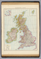
British Isles. (with) The Channel Islands. (with) The Shetland Islands. (Published at the office of "The Times," London, 1895)
List No
1010.010
Note
Color map with 2 insets. Shows railways, settlements, counties, etc. Relief shown by hachures and spot heights.
Full Title
England and Wales, north. (Published at the office of "The Times," London, 1895)
List No
1010.011
Note
Color map. Shows settlements, counties, railroads, canals, lighthouses, lightships, parks, etc.
Full Title
England and Wales, south. (Published at the office of "The Times," London, 1895)
List No
1010.012
Note
Color map. Shows settlements, counties, railroads, canals, lighthouses, lightships, parks, etc.
Full Title
Scotland. (with) Orkney Islands. (with) Shetland Islands. (Published at the office of "The Times," London, 1895)
List No
1010.013
Note
Color map with 2 insets. Shows settlements, counties, railroads, canals, lighthouses, lightships, parks, etc.
Full Title
Ireland. (Published at the office of "The Times," London, 1895)
List No
1010.014
Note
Color map. Relief shown by hachures and spot heights. Show settlements, counties, railroads, canals, etc.
Full Title
France, general map. (Published at the office of "The Times," London, 1895)
List No
1010.016
Note
Color map. Relief shown by hachures and spot heights. Shows settlements, departments, forts, canals, etc.
Full Title
France, North. (with) Brittany. (with) Environs of Paris. (Published at the office of "The Times," London, 1895)
List No
1010.017
Note
Color map with 2 insets. Relief shown by hachures and spot heights. Shows settlements, railroads, canals, etc.
Full Title
France, South. (with) Corsica. (Published at the office of "The Times," London, 1895)
List No
1010.018
Note
Color map with inset. Relief shown by hachures and spot heights. Shows settlements, railroads, canals, etc.
Full Title
Belgium and Luxemburg. (with) Environs of Charleroi. (Published at the office of "The Times," London, 1895)
List No
1010.019
Note
Color map with inset. Relief shown by hachures and spot heights. Shows settlements, railroads, canals, etc.
Full Title
Denmark. Alsace-Lorraine and Palatinate of Bavaria. (with) Bornholm. (with) Iceland. (with) The Faroe Isles. (Published at the office of "The Times," London, 1895)
List No
1010.021
Note
Two color maps with 3 insets. Relief shown by hachures and spot heights. Show settlements, railroads, canals, etc. Scale of Alsace-Lorraine-Palatinate map 1:870,000.
Full Title
Germany, general map. (with) Berlin and environs. (Published at the office of "The Times," London, 1895)
List No
1010.022
Note
Color map with inset. Relief shown by hachures and spot heights. Shows settlements, railroads, canals, etc.
Full Title
Hanover, Schleswig-Holstein and lesser North Germain (i.e. German) states. (with) Environs of Hamburg. (with Free port district, Hamburg). (with) Principality of Birkenfeld. (with) Environs of Kiel. (Published at the office of "The Times," London, 1895)
List No
1010.023
Note
Color map with 4 insets. Relief shown by hachures and spot heights. Shows settlements, railroads, canals, etc.
Full Title
Kingdom of Saxony. (with) Environs of Dresden. (with) The Saxon Switzerland. (Published at the office of "The Times," London, 1895)
List No
1010.024
Note
Color map with 2 insets. Relief shown by hachures and spot heights. Shows settlements, railroads, canals, etc.
Full Title
Wurtemberg and Bavaria. (with) Environs of Stuttgart. (Published at the office of "The Times," London, 1895)
List No
1010.026
Note
Color map with inset. Relief shown by hachures and spot heights. Shows settlements, railroads, canals, etc.
Full Title
Rhenish Prussia, Westphalia, Hesse-Nassau, Waldeck, Lippe and Grand-Duchy of Hesse. (with) The manufacturing district of Rhenish Prussia and Westphalia. (with) The Rheingau. (Published at the office of "The Times," London, 1895)
List No
1010.027
Note
Color map with 2 insets. Relief shown by hachures and spot heights. Shows settlements, railroads, canals, etc.
Full Title
Grand-Duchy of Baden. (Published at the office of "The Times," London, 1895)
List No
1010.028
Note
Color map. Relief shown by hachures and spot heights. Shows settlements, railroads, canals, etc.
Full Title
Austria-Hungary, general map (with) Vienna & environs. (Published at the office of "The Times," London, 1895)
List No
1010.030
Note
Color map with inset. Relief shown by hachures. Shows settlements, boundaries, railroads, canals, etc.
Full Title
The Austrian Alps. (Published at the office of "The Times," London, 1895)
List No
1010.031
Note
Color map. Relief shown by hachures and spot heights. Shows settlements, railroads, roads, trails, canals, mineral baths, etc.
Full Title
Hungary. (Published at the office of "The Times," London, 1895)
List No
1010.032
Note
Color map. Relief shown by hachures and spot heights. Shows settlements, railroads, canals, etc.
Full Title
Switzerland. (Published at the office of "The Times," London, 1895)
List No
1010.034
Note
Color map. Relief shown by hachures and spot heights. Shows settlements, railroads, canals, etc.
Full Title
General map of the Alps. (Published at the office of "The Times," London, 1895)
List No
1010.035
Note
Color map. Relief shown by altitude tints, hachures and spot heights. Shows settlements, rivers, etc.
Full Title
Spain and Portugal. (Published at the office of "The Times," London, 1895)
List No
1010.037
Note
Color map. Relief shown by hachures and spot heights. Shows settlements, railroads, canals, etc.
Full Title
Mediterranean Sea, Western. (with) The Strait of Gibraltar. (Published at the office of "The Times," London, 1895)
List No
1010.038
Note
Color map with inset. Relief shown by hachures and spot heights. Shows settlements, railroads, canals, etc.
Full Title
Italy, general map. (with) The lagoons of Venice. (with) Environs of Naples. (Published at the office of "The Times," London, 1895)
List No
1010.040
Note
Color map with 2 insets. Relief shown by hachures and spot heights. Shows settlements, railroads, canals, etc.
Full Title
Italy, North. (Published at the office of "The Times," London, 1895)
List No
1010.041
Note
Color map. Relief shown by hachures and spot heights. Shows settlements, railroads, canals, etc.
Full Title
Southern Scandinavia. Norway and Sweden. (with Environs of Stockholm. Published at the office of "The Times," London, 1895)
List No
1010.043
Note
Two color maps with inset. Relief shown by hachures and spot heights. Show settlements, railroads, canals, etc. Norway and Sweden at 1:6,000,000 scale.
Full Title
European Russia. (Published at the office of "The Times," London, 1895)
List No
1010.044
Note
Color map. Relief shown by hachures and spot heights. Shows settlements, railroads, canals, etc.
Full Title
The Balkan Peninsula. (Published at the office of "The Times," London, 1895)
List No
1010.045
Note
Color map. Relief shown by hachures and spot heights. Shows settlements, railroads, etc.
Full Title
The Caucasus. (Published at the office of "The Times," London, 1895)
List No
1010.046
Note
Color map. Relief shown by hachures and spot heights. Shows settlements, railroads, canals, etc.
Full Title
Asia, general map. (Published at the office of "The Times," London, 1895)
List No
1010.048
Note
Color map. Relief shown by hachures and spot heights. Show boundaries, cities, etc.
Full Title
Palestine. (with) Highlands of Judea. (Published at the office of "The Times," London, 1895)
List No
1010.049
Note
Color map with inset. Relief shown by hachures and spot heights. Shows settlements, railroads, etc. Judea map at 1:500,000 scale.
Full Title
Central Asia and India. (Published at the office of "The Times," London, 1895)
List No
1010.051
Note
Color map. Relief shown by hachures and spot heights. Shows settlements, rivers, etc.
Full Title
India, North. (Published at the office of "The Times," London, 1895)
List No
1010.052
Note
Color map. Relief shown by hachures and spot heights. Shows settlements, railroads, canals, etc.
Full Title
India, South. Burma and the Malay Peninsula. (with) North-west Provinces. (Published at the office of "The Times," London, 1895)
List No
1010.053
Note
Two color maps with 2 insets. Relief shown by hachures and spot heights. Show settlements, railroads, canals, etc.
Full Title
Afghanistan and Baluchistan. (Published at the office of "The Times," London, 1895)
List No
1010.054
Note
Color map. Relief shown by hachures and spot heights. Shows British and Russian possessions, settlements, railroads, rivers, etc.
Full Title
China and Japan. (with) Environs of Peking. (with) Environs of Tokio. (Published at the office of "The Times," London, 1895)
List No
1010.056
Note
Color map with 2 insets. Relief shown by hachures and spot heights. Shows settlements, railroads, canals, etc.
Full Title
North America. (with) Southern Mexico. (Published at the office of "The Times," London, 1895)
List No
1010.058
Note
Color map with inset. Relief shown by hachures and spot heights. Shows settlements, railroads, etc. Scale of inset: 1:10,000,000.
Full Title
British North America. (Published at the office of "The Times," London, 1895)
List No
1010.059
Note
Color maps. Relief shown by hachures and spot heights. Shows settlements, railroads, canals, etc.
Full Title
Canada, Eastern. (Published at the office of "The Times," London, 1895)
List No
1010.060
Note
Color map. Relief shown by hachures and spot heights. Show settlements, railroads, canals, etc.
Full Title
United States, general map. (Published at the office of "The Times," London, 1895)
List No
1010.062
Note
Color map. Relief shown by hachures and spot heights. Shows settlements, railroads, canals, etc.
Full Title
United States, western. United States, north-eastern. (with Environs of New York City. Published at the office of "The Times," London, 1895)
List No
1010.063
Note
Two color maps with inset. Relief shown by hachures and spot heights. Show settlements, railroads, canals, etc.
Full Title
Central America and West Indies. (with) Isthmus of Panama. (Published at the office of "The Times," London, 1895)
List No
1010.064
Note
Color map with inset. Relief shown by hachures and spot heights. Show settlements, railroads, etc.
Full Title
South America. (with) Rio de Janeiro and Espirito Santo. (with) South-east Brazil and Uruguay. (with) Chile. (Published at the office of "The Times," London, 1895)
List No
1010.066
Note
Color maps with inset. Relief shown by hachures and spot heights. Shows settlements, railroads, etc. Scale of insets: 1:9,500,000-1:10,000,000.
Full Title
Africa, general map. (with) Azores Islands. (with) Reunion and Mauritius. (Published at the office of "The Times," London, 1895)
List No
1010.067
Note
Color map with 2 insets. Relief shown by hachures and spot heights. Shows settlements, colonial and other boundaries, etc.
Full Title
Egypt. (with) Environs of Cairo. (with) Environs of Khartum. (Published at the office of "The Times," London, 1895)
List No
1010.068
Note
Color map with 2 insets. Relief shown by hachures and spot heights. Shows settlements, railroads, telegraph lines, etc.
Full Title
Africa, north-east. (Published at the office of "The Times," London, 1895)
List No
1010.070
Note
Color map with inset. Relief shown by hachures and spot heights. Shows settlements, canal, etc.
Full Title
Africa, north-west. (with) Cape Verd Islands. (Published at the office of "The Times," London, 1895)
List No
1010.071
Note
Color map with inset. Relief shown by hachures and spot heights. Shows settlements, tribes, European colonial boundaries, etc.
Full Title
Africa, south of the Equator. (Published at the office of "The Times," London, 1895)
List No
1010.072
Note
Color map. Relief shown by hachures and spot heights. Shows settlements, railroads, etc.
Full Title
West Africa, colonial map. (with) Mouth of the Cameroons River. (Published at the office of "The Times," London, 1895)
List No
1010.073
Note
Three color maps with inset. Relief shown by hachures and spot heights. Show settlements, colonial boundaries, etc. Contents: The Slave coast -- The Cameroons District -- The Lower Congo Region.
Full Title
Polynesian Groups (composed of) Fiji, Viti, Islands; Sandwich, Hawaii, Islands; Samoa or Navigator Islands. South Polar Regions. (with) Kerguelen Island. (with) Victoria Land. (Published at the office of "The Times," London, 1895)
List No
1010.075
Note
Four color maps with 3 insets. Relief shown by hachures and spot heights. Show settlements, etc. Includes inset of "County of Rutland" for comparison.
Full Title
Australia and New Zealand. (with) Environs of Melbourne. (with) Environs of Sydney. (Published at the office of "The Times," London, 1895)
List No
1010.077
Note
Color map with 2 insets. Relief shown by hachures and spot heights. Shows settlements, railroads, telegraph lines, etc.
Full Title
Victoria and New South Wales. (Published at the office of "The Times," London, 1895)
List No
1010.078
Note
Color map. Relief shown by hachures and spot heights. Shows settlements, railroads, etc.
Author
Andree, Richard
Full Title
(Covers to) Richard Andree's Allgemeiner Handatlas in sechsundachtzig Karten mit erlauterndem Text. Herausgegeben von der Geographischen Anstalt von Velhagen & Klasing in Leipzig. Bielefeld und Leipzig, Verlag Von Velhagen & Klasing 1881.
List No
1494A
Note
Covers are half leather dark green cloth covered boards ("economy version") with "Andree's Handatlas" stamped in gilt on the front cover and the restored leather spine. David Rumsey Collection copy: the word "Handatlas" is cut off on the remainder of the original spine.
Author
Andree, Richard
Full Title
(Title Page to) Richard Andree's Allgemeiner Handatlas in sechsundachtzig Karten mit erlauterndem Text. Herausgegeben von der Geographischen Anstalt von Velhagen & Klasing in Leipzig. Bielefeld und Leipzig, Verlag Von Velhagen & Klasing 1881.
List No
1494B
Note
Maps are printed in full color. Covers are half leather dark green cloth covered boards ("economy version") with "Andree's Handatlas" stamped in gilt on the front cover and the restored leather spine. David Rumsey Collection copy: the word "Handatlas" is cut off on the remainder of the original spine.
Author
Andree, Richard
Full Title
(Contents to) Richard Andree's Allgemeiner Handatlas in sechsundachtzig Karten mit erlauterndem Text. Herausgegeben von der Geographischen Anstalt von Velhagen & Klasing in Leipzig. Bielefeld und Leipzig, Verlag Von Velhagen & Klasing 1881.
List No
1494C
Note
"Inhalt des Atlas."
Full Title
Nordlicher Sternhimmel. Sudlicher Sternhimmel. (Richard Andree. Herausgegeben von der Geographischen Anstalt von Velhagen & Klasing in Leipzig. 1881)
List No
1494.001
Note
Two colored maps.
Full Title
Westliche Halbkugel. Ostliche Halbkugel. (with) Wasser-Halbkugel. (with) Die funf Erdtheile in Mercators Projection. (with) Land-Halbkugel. (Richard Andree. Herausgegeben von der Geographischen Anstalt von Velhagen & Klasing in Leipzig. 1881)
List No
1494.002
Note
Colored map. Double hemisphere world map. Relief shown by hachures and altitude tints.
Full Title
Das Sonnensystem. Mondkarte. (Richard Andree. Herausgegeben von der Geographischen Anstalt von Velhagen & Klasing in Leipzig. 1881)
List No
1494.003
Note
Two maps, one in color. Relief shown by hachures. Includes insets.
Full Title
Karte des Weltverkehrs und der Meeresstromungen in Mercators Projektion. (with) Schematisches Profil einiger Haupt-Berggipfel der Erde. (Richard Andree. Herausgegeben von der Geographischen Anstalt von Velhagen & Klasing in Leipzig. 1881)
List No
1494.005
Note
Colored map with profile. Shows shipping routes, telegraph lines, railroads, canals, warm and cold currents, etc. "IX.1879."
Full Title
Vegetationsgebiete der Erde. Die Verbreitung der Thiere. (with) Die Verbreitung des Lowen und Elephanten in Asien. (with) Die zoogeogr. Gebiete der Erde. Nach A.R. Wallace. (Richard Andree. Herausgegeben von der Geographischen Anstalt von Velhagen & Klasing in Leipzig. 1881)
List No
1494.006
Note
Two colored maps with 2 insets.
Full Title
Karte der Nordpolarregion. (with) Nowaja Semlja. (with) Spitzbergen und die Baren Insel. (with) Sud-west Gronland. (with) Kuste von Ost-Gronland zwischen 72 u. 770 nordl. Br. Nach den Aufnahmen der zweiten Deutschen Nord-Pol Expedit. 1869-1870. (Richard Andree. Herausgegeben von der Geographischen Anstalt von Velhagen & Klasing in Leipzig. 1881)
List No
1494.008
Note
Colored map with 4 insets. Relief shown by hachures and spot heights. "VIII.1879."
Full Title
Karte der Sudpolarregion. Polynesische Inselgruppen: Viti-Fidschi, Inseln. Hawaii-Sandwich, Inseln. Samoa-Schiffer, Inseln. (with) Victoria-Land. (Richard Andree. Herausgegeben von der Geographischen Anstalt von Velhagen & Klasing in Leipzig. 1881)
List No
1494.009
Note
Four color maps with 2 insets. Relief shown by hachures and spot heights. "IX.1879."
Full Title
Europa politisch. (Richard Andree. Herausgegeben von der Geographischen Anstalt von Velhagen & Klasing in Leipzig. 1881)
List No
1494.011
Note
Colored map. Relief shown by hachures and spot heights. "III.1880."
Full Title
Atlantischer Ocean, Meerestiefen und Telegraphenkabel. (Richard Andree. Herausgegeben von der Geographischen Anstalt von Velhagen & Klasing in Leipzig. 1881)
List No
1494.012
Note
Color map. Depths shown by soundings and color. "II.1880."
Full Title
Deutschland physikalisch. (Richard Andree. Herausgegeben von der Geographischen Anstalt von Velhagen & Klasing in Leipzig. 1881)
List No
1494.014
Note
Colored map. Relief shown by hachures, spot heights and altitude tints. Shows rivers, lakes, canals, cities, etc. "X.1880."
Full Title
Isothermen- und Windkatre (i.e. Windkarte) der Erde. Religionskarte von Europa. (Richard Andree. Herausgegeben von der Geographischen Anstalt von Velhagen & Klasing in Leipzig. 1881)
List No
1494.015
Note
Two colored maps. Prime meridian on Religionskarte von Europa: Ferro. "VII.1880."
Full Title
Deutschland politisch. (Richard Andree. Herausgegeben von der Geographischen Anstalt von Velhagen & Klasing in Leipzig. 1881)
List No
1494.017
Note
Colored map. Relief shown by hachures. Shows cities, railroads, canals, rivers, etc. "VI.1880."
Full Title
Hohenschichtenkarte von Deutschland. Bevolkerungsdichtigkeit von Deutschland. (Richard Andree. Herausgegeben von der Geographischen Anstalt von Velhagen & Klasing in Leipzig. 1881)
List No
1494.018
Note
Two colored maps. Relief shown by altitude tints and spot heights.
Full Title
Wurttemberg und Bayern. (Richard Andree. Herausgegeben von der Geographischen Anstalt von Velhagen & Klasing in Leipzig. 1881)
List No
1494.020
Note
Colored map. Relief shown by hachures and spot heights. Shows settlements, railroads, canals, roads, baths, castles, ruins, convents, glassworks, etc. "VI.1880."
Full Title
Grossherzogthum Baden. (Richard Andree. Herausgegeben von der Geographischen Anstalt von Velhagen & Klasing in Leipzig. 1881)
List No
1494.021
Note
Colored map. Relief shown by hachures and spot heights. Shows settlements, railroads, roads, canals, rivers, etc. "VIII.1879."
Full Title
Rheinprovinz, Westfalen, Hessen-Nassau, Waldeck und Grossherzogthum Hessen. (Richard Andree. Herausgegeben von der Geographischen Anstalt von Velhagen & Klasing in Leipzig. 1881)
List No
1494.023
Note
Colored map. Relief shown by hachures and spot heights. Shows settlements, railroads, canals, roads, etc. "IV.1880."
Full Title
Provinz Sachsen, Mecklenburg und Anhalt. (Richard Andree. Herausgegeben von der Geographischen Anstalt von Velhagen & Klasing in Leipzig. 1881)
List No
1494.024
Note
Colored map. Relief shown by hachures and spot heights. Shows railroads, roads, canals, settlements, etc. "VI.1880."
Full Title
Hannover, Schleswig-Holstein und kleinere norddeutsche Staaten. (with) Furstenthum Birkenfeld. (Richard Andree. Herausgegeben von der Geographischen Anstalt von Velhagen & Klasing in Leipzig. 1881)
List No
1494.026
Note
Colored map with inset. Relief shown by hachures and spot heights. Shows settlements, railroads, roads, canals, forts, castles, ruins, etc. "IX.1879."
Full Title
Provinzen Brandenburg und Posen. (Richard Andree. Herausgegeben von der Geographischen Anstalt von Velhagen & Klasing in Leipzig. 1881)
List No
1494.027
Note
Colored map. Relief shown by hachures and spot heights. Show settlements, railroads, roads, canals, etc. "IX.1879."
Full Title
Konigreich Sachsen und Thuringische Staaten. (Richard Andree. Herausgegeben von der Geographischen Anstalt von Velhagen & Klasing in Leipzig. 1881)
List No
1494.029
Note
Colored map. Relief shown by hachures and spot heights. Shows railroads, canals, roads, settlements, etc. "X.1880."
Full Title
Provinzen Ost- und Westpreussen. (Richard Andree. Herausgegeben von der Geographischen Anstalt von Velhagen & Klasing in Leipzig. 1881)
List No
1494.030
Note
Colored map. Relief shown by hachures and spot heights. Shows settlements, railroads, canals, etc. "XI.1880."
Full Title
Die Oesterreichischen Alpenlander. (Richard Andree. Herausgegeben von der Geographischen Anstalt von Velhagen & Klasing in Leipzig. 1881)
List No
1494.032
Note
Colored map. Relief shown by hachures and spot heights. Shows settlements, railroads, roads, trails, canals, etc. Prime meridians: Greenwich, Ferro and Paris. "IX.1880."
Full Title
Ungarn. (Richard Andree. Herausgegeben von der Geographischen Anstalt von Velhagen & Klasing in Leipzig. 1881)
List No
1494.033
Note
Colored map. Relief shown by hachures and spot heights. Shows settlements, ruins, railroads, canals, etc. "VIII.1880."
Full Title
Oesterreich-Ungarische Monarchie. (Richard Andree. Herausgegeben von der Geographischen Anstalt von Velhagen & Klasing in Leipzig. 1881)
List No
1494.035
Note
Colored map. Relief shown by hachures and spot heights. Shows railroads, roads, canals, settlements, etc. "VIII.1880."
Full Title
Wien. Prag. Buda-Pest. Religionskarte von Oesterreich-Ungarn. (Richard Andree. Herausgegeben von der Geographischen Anstalt von Velhagen & Klasing in Leipzig. 1881)
List No
1494.036
Note
Four colored maps. Relief shown by hachures and spot heights. Prime meridian: Ferro.
Full Title
Die Schweiz. (Richard Andree. Herausgegeben von der Geographischen Anstalt von Velhagen & Klasing in Leipzig. 1881)
List No
1494.038
Note
Colored map. Relief shown by hachures and spot heights. "II.1881."
Full Title
Italien nordliche Halfte. (Richard Andree. Herausgegeben von der Geographischen Anstalt von Velhagen & Klasing in Leipzig. 1881)
List No
1494.039
Note
Colored map. Relief shown by hachures and spot heights. Shows railroads, canals, settlements, forts, castles, ruins, etc. "I.1881."
Full Title
Frankreich. (Richard Andree. Herausgegeben von der Geographischen Anstalt von Velhagen & Klasing in Leipzig. 1881)
List No
1494.041
Note
Colored map. Relief shown by hachures and spot heights. Shows settlements, forts, railroads, canals, etc. "IX.1880."
Full Title
Franzosische Mittelmeerkuste. Paris und die untere Seine. (Richard Andree. Herausgegeben von der Geographischen Anstalt von Velhagen & Klasing in Leipzig. 1881)
List No
1494.042
Note
Two colored maps. Relief shown by hachures and spot heights. Shows settlements, railroads, roads, canals, etc. "VIII.1880."
Full Title
Spanien und Portugal. (Richard Andree. Herausgegeben von der Geographischen Anstalt von Velhagen & Klasing in Leipzig. 1881)
List No
1494.044
Note
Colored map. Relief shown by hachures and spot heights. Shows roads, railroads, settlements, etc. "X.1879."
Full Title
Vulkane und Koralleninseln. (Richard Andree. Herausgegeben von der Geographischen Anstalt von Velhagen & Klasing in Leipzig. 1881)
List No
1494.004
Note
Color map. Insets: Der Aetna -- Der Vesuv -- Pico de Teyde auf Teneriffa -- Mangarewa oder Gambier Id. -- Mount Wellington auf dem Isthmus v. Auckland in Neu-Seeland -- Santorin -- Nord-Friesland um 1240 und jetzt. Includes 3 sections.
Full Title
Volkerkarte von Europa. (with) Sprachgebiet der Basken. (with) Sprachgebiet der Bretonen. (with) Die Sprachgrenzen in Sud-Tirol. (with) Die Flamische Sprachgrenze in Belgien. (Richard Andree. Herausgegeben von der Geographischen Anstalt von Velhagen & Klasing in Leipzig. 1881)
List No
1494.010
Note
Colored map with 4 insets. "II.1880."
Full Title
Grosser Ocean, Meerestiefen und Telegraphenkabel. (with) Tahiti und Moorea. (with) Tonga, Freundschafts In. (with) Tongatabu. (with) Markesas Inseln. (with) Nukuhiva. (with) Hivaoa und Tahuata. (Richard Andree. Herausgegeben von der Geographischen Anstalt von Velhagen & Klasing in Leipzig. 1881)
List No
1494.013
Note
Colored map with 6 insets. Depths shown by soundings and color.
Full Title
Provinz Schlesien. (Richard Andree. Herausgegeben von der Geographischen Anstalt von Velhagen & Klasing in Leipzig. 1881)
List No
1494.025
Note
Colored map. Relief shown by hachures and spot heights. Shows railroads, roads, canals, settlements, etc. "VIII.1879."
Full Title
Provinz Pommern. (Richard Andree. Herausgegeben von der Geographischen Anstalt von Velhagen & Klasing in Leipzig. 1881)
List No
1494.028
Note
Colored map. Relief shown by hachures and spot heights. Show settlements, railroads, roads, canals, etc. "XI.1880."
Full Title
Bohmen und Mahren. (Richard Andree. Herausgegeben von der Geographischen Anstalt von Velhagen & Klasing in Leipzig. 1881)
List No
1494.031
Note
Colored map. Relief shown by hachures and spot heights. Shows settlements, railroads, canals, etc. "VII.1880."
Full Title
Volkerkarte von Oesterreich-Ungarn. (Richard Andree. Herausgegeben von der Geographischen Anstalt von Velhagen & Klasing in Leipzig. 1881)
List No
1494.034
Note
Colored map. Includes inset: Sudlicher Theil von Dalmatien. "III.1880."
Full Title
Belgien und Luxemburg. (Richard Andree. Herausgegeben von der Geographischen Anstalt von Velhagen & Klasing in Leipzig. 1881)
List No
1494.043
Note
Colored map. Relief shown by hachures and spot heights. Shows settlements, railroads, roads, canals, etc. "XII.1879."
Full Title
Volkerkarte der Erde. Religionskarte der Erde. (Richard Andree. Herausgegeben von der Geographischen Anstalt von Velhagen & Klasing in Leipzig. 1881)
List No
1494.007
Note
Two colored maps.
Full Title
Sprachenkarte von Deutschland. Religionskarte von Deutschland. (Richard Andree. Herausgegeben von der Geographischen Anstalt von Velhagen & Klasing in Leipzig. 1881)
List No
1494.016
Note
Two colored maps.
Full Title
Regenkarte von Deutschland. Mittlere Jahrestemperatur von Deutschland. (Richard Andree. Herausgegeben von der Geographischen Anstalt von Velhagen & Klasing in Leipzig. 1881)
List No
1494.019
Note
Two colored maps.
Full Title
Elsass-Lothringen und Bayerische Pfalz. (Richard Andree. Herausgegeben von der Geographischen Anstalt von Velhagen & Klasing in Leipzig. 1881)
List No
1494.022
Note
Colored map. Relief shown by hachures and spot heights. Shows settlements, railroads, roads, canals, rivers, etc. "VIII.1879."
Full Title
Sprachenkarte der Schweiz. Religionskarte der Schweiz. (Richard Andree. Herausgegeben von der Geographischen Anstalt von Velhagen & Klasing in Leipzig. 1881)
List No
1494.037
Note
Two colored maps. Prime meridian: Ferro.
Full Title
Mittelmeerlander, westliche Halfte. (with) Die Meerenge von Gibraltar. (Richard Andree. Herausgegeben von der Geographischen Anstalt von Velhagen & Klasing in Leipzig. 1881)
List No
1494.045
Note
Colored map. Relief shown by hachures and spot heights. Shows settlements, rivers, shipping routes, etc. "XII.1879."
Full Title
Mittelmeerlander ostliche Halfte. (with) Das Nil-Delta und der Sues-Canal. (Richard Andree. Herausgegeben von der Geographischen Anstalt von Velhagen & Klasing in Leipzig. 1881)
List No
1494.046
Note
Colored map. Relief shown by hachures and spot heights. Shows settlements, rivers, shipping routes, etc. "I.1881."
Full Title
Balkanhalbinsel. (Richard Andree. Herausgegeben von der Geographischen Anstalt von Velhagen & Klasing in Leipzig. 1881)
List No
1494.047
Note
Colored map. Relief shown by hachures and spot heights. Shows settlements, castles, ruins, etc. Includes inset. "I.1881."
Full Title
Volkerkarte der Balkanhalbinsel. Konstantinopel und das Marmarameer. (Richard Andree. Herausgegeben von der Geographischen Anstalt von Velhagen & Klasing in Leipzig. 1881)
List No
1494.048
Note
Two colored maps. Relief shown by hachures and spot heights. "I.1881."
Full Title
Niederlande. (Richard Andree. Herausgegeben von der Geographischen Anstalt von Velhagen & Klasing in Leipzig. 1881)
List No
1494.049
Note
Colored map. Relief shown by hachures. Shows railroads, canals, settlements, baths, etc. "XI.1879."
Full Title
Grossbritannien und Irland. (with) Die Canal Inseln. (with) Die Shetland Inseln. (Richard Andree. Herausgegeben von der Geographischen Anstalt von Velhagen & Klasing in Leipzig. 1881)
List No
1494.050
Note
Colored map. Relief shown by hachures and spot heights. Shows settlements, railroads, canals, counties, etc. Insets also at 1:2,500,000. "I.1880."
Full Title
Danemark. (with) Bornholm. (with) Island. (with) Die Far-Oer. (Richard Andree. Herausgegeben von der Geographischen Anstalt von Velhagen & Klasing in Leipzig. 1881)
List No
1494.051
Note
Colored map. Relief shown by hachures and spot heights. Shows settlements, railroads, canals, roads, forts, etc. "I.1880."
Full Title
Schweden und Norwegen. (Richard Andree. Herausgegeben von der Geographischen Anstalt von Velhagen & Klasing in Leipzig. 1881)
List No
1494.052
Note
Colored map. Relief shown by hachures and spot heights. Shows settlements, railroads, canals, forts, etc. Covers also Denmark and most of Finland. "VII 1879."
Full Title
Europaisches Russland. (Richard Andree. Herausgegeben von der Geographischen Anstalt von Velhagen & Klasing in Leipzig. 1881)
List No
1494.053
Note
Colored map. Relief shown by hachures and spot heights. Shows settlements, railroads, canals, etc. "VIII.1879."
Full Title
Volkerkarte von Russland. (with) Die Volker des Kaukasus nach Rittich. (with) Finnischer Meerbusen. (Richard Andree. Herausgegeben von der Geographischen Anstalt von Velhagen & Klasing in Leipzig. 1881)
List No
1494.054
Note
Colored map with 2 insets. "I.1880."
Full Title
Volkerkarte von Asien. (Richard Andree. Herausgegeben von der Geographischen Anstalt von Velhagen & Klasing in Leipzig. 1881)
List No
1494.055
Note
Colored map. "XII.1879."
Full Title
Asien. (Richard Andree. Herausgegeben von der Geographischen Anstalt von Velhagen & Klasing in Leipzig. 1881)
List No
1494.056
Note
Colored map. Relief shown by hachures and spot heights. Shows rivers, settlements, etc. "VIII.1879."
Full Title
Vorderasien und Persien. (Richard Andree. Herausgegeben von der Geographischen Anstalt von Velhagen & Klasing in Leipzig. 1881)
List No
1494.057
Note
Colored map. Relief shown by hachures and spot heights. Shows settlements, railroads, etc. "IX.1879."
Full Title
China and Japan. (with) Umgegend von Peking. (with) Umgegend von Tokio. (Richard Andree. Herausgegeben von der Geographischen Anstalt von Velhagen & Klasing in Leipzig. 1881)
List No
1494.058
Note
Colored map. Relief shown by hachures and spot heights. Shows settlements, provinces, rivers, etc. Covers also Korea. "IX.1880."
Full Title
Centralasien und Ostindien. (Richard Andree. Herausgegeben von der Geographischen Anstalt von Velhagen & Klasing in Leipzig. 1881)
List No
1494.059
Note
Colored map. Relief shown by hachures and spot heights. Shows settlements, railroads, rivers, etc. "X.1880."
Full Title
Hinterindien und der Malayische Archipel. (with) Java. (Richard Andree. Herausgegeben von der Geographischen Anstalt von Velhagen & Klasing in Leipzig. 1881)
List No
1494.060
Note
Colored map. Relief shown by hachures and spot heights. Shows settlements, rivers, etc. Includes an inset of the Netherlands at same scale. "X.1880."
Full Title
Palastina. (Richard Andree. Herausgegeben von der Geographischen Anstalt von Velhagen & Klasing in Leipzig. 1881)
List No
1494.061
Note
Colored map. Relief shown by hachures and spot heights. Shows settlements, forts, ruins, roads, etc. "VII.1880."
Full Title
Nordamerika. (Richard Andree. Herausgegeben von der Geographischen Anstalt von Velhagen & Klasing in Leipzig. 1881)
List No
1494.062
Note
Colored map. Relief shown by hachures and spot heights. Shows cities, national boundaries, rivers, etc. "I.1881."
Full Title
Sudamerika nordliches Blatt. (with) Rio de Janeiro und Espirito Santo. (Richard Andree. Herausgegeben von der Geographischen Anstalt von Velhagen & Klasing in Leipzig. 1881)
List No
1494.063
Note
Colored map. Relief shown by hachures and spot heights. Shows cities, states in Brazil, Indian tribes, rivers, etc.
Full Title
Sudamerika sudliches Blatt. (with) Chile. (with) Sudost-Brasilien mit den Deutschen Colonien und Uruguay. (Richard Andree. Herausgegeben von der Geographischen Anstalt von Velhagen & Klasing in Leipzig. 1881)
List No
1494.064
Note
Colored map. Relief shown by hachures and spot heights. Shows cities, rivers, etc. "II.1881."
Full Title
Vereinigte Staaten von Nordamerika. (Richard Andree. Herausgegeben von der Geographischen Anstalt von Velhagen & Klasing in Leipzig. 1881)
List No
1494.065
Note
Colored map. Relief shown by hachures and spot heights. Shows settlements, state boundaries, railroads, rivers, etc. "II.1881."
Full Title
Die Pacifischen Staaten der Union. (Richard Andree. Herausgegeben von der Geographischen Anstalt von Velhagen & Klasing in Leipzig. 1881)
List No
1494.066
Note
Colored map. Relief shown by hachures and spot heights. Shows settlements, railroads, canals, etc. Covers California, Nevada, Oregon and parts of Washington, Idaho, Montana, Utah and Arizona. "II.1881."
Full Title
Die Nordost-Staaten der Union. (Richard Andree. Herausgegeben von der Geographischen Anstalt von Velhagen & Klasing in Leipzig. 1881)
List No
1494.067
Note
Colored map. Relief shown by hachures and spot heights. Shows settlements, railroads, canals, rivers, etc. Includes inset map of New York City and vicinity. "XI.1880."
Full Title
Australien und Neuseeland. (Richard Andree. Herausgegeben von der Geographischen Anstalt von Velhagen & Klasing in Leipzig. 1881)
List No
1494.068
Note
Colored map. Relief shown by hachures and spot heights. Shows settlements, railroads, overland telegraph lines, rivers, etc. "XI.1880."
Full Title
Centralamerika und Westindien. (with) Istmus von Panama. (Richard Andree. Herausgegeben von der Geographischen Anstalt von Velhagen & Klasing in Leipzig. 1881)
List No
1494.069
Note
Colored map. Relief shown by hachures and spot heights. Shows settlements, national boundaries, rivers, etc. "XI.1880."
Full Title
Die Nillander. (Richard Andree. Herausgegeben von der Geographischen Anstalt von Velhagen & Klasing in Leipzig. 1881)
List No
1494.070
Note
Colored map. Relief shown by hachures and spot heights. Shows settlements, rivers, etc. "XII 1879."
Full Title
Africa. (Richard Andree. Herausgegeben von der Geographischen Anstalt von Velhagen & Klasing in Leipzig. 1881)
List No
1494.071
Note
Colored map. Relief shown by hachures and spot heights. Shows settlements, roads, rivers, etc. "XII.1879."
Full Title
Senegambien. Goldkuste und Kapland: Goldkuste u. Niger Delta, Sud-Afrika. (Richard Andree. Herausgegeben von der Geographischen Anstalt von Velhagen & Klasing in Leipzig. 1881)
List No
1494.072
Note
Three colored maps on 1 sheet. Relief shown by hachures and spot heights. Show settlements, tribes, colonial boundaries, railroads, roads, rivers, missions, etc. Sud-Afrika map at 1:13,250,000 scale.
Full Title
Italien sudliche Halfte. (with) Neapel und Umgebung. (Richard Andree. Herausgegeben von der Geographischen Anstalt von Velhagen & Klasing in Leipzig. 1881)
List No
1494.040
Note
Colored map. Relief shown by hachures and spot heights. Shows railroads, canals, settlements, forts, castles, ruins, etc. "IX.1880."
Author
Allardt, G. F.
Full Title
Sale map no. 11. Salt marsh and tide lands situate in the counties of Alameda & Contra Costa, state of California. To be sold at public auction by order of the Board of Tide Land Commissioners ... Greenbaum & Co. Auctioneers. Sale to commence Wednesday July 10th 1872, at 11 A.M. at the sales rooms of Greenbaum & Co. Nos. 115 & 117 Bush Street, San Francisco. R.P. Johnson, Edgar Briggs, C.M. Stratton, Board of Tide Land Commissioners. J.M. Currier, Secretary. G.F. Allardt, Chief Engineer. Lith. Britton & Rey S.F. (inset) Tide lands in Lake Merritt.
List No
3972.000
Note
This map is double the size of the usual tide land maps and shows the shore of the east bay from Oakland north to Point San Pablo. Cadastral map showing drainage, township and section lines, land ownership, ranchos, lot numbers, railroads, etc. Map is without color (for hand colored copy see our 4470). Printed on 2 sheets, mounted together.
Author
Allardt, G. F.
Full Title
Sale map no. 11. Salt marsh and tide lands situate in the counties of Alameda & Contra Costa, state of California. To be sold at public auction by order of the Board of Tide Land Commissioners ... Greenbaum & Co. Auctioneers. Sale to commence Wednesday July 10th 1872, at 11 A.M. at the sales rooms of Greenbaum & Co. Nos. 115 & 117 Bush Street, San Francisco. R.P. Johnson, Edgar Briggs, C.M. Stratton, Board of Tide Land Commissioners. J.M. Currier, Secretary. G.F. Allardt, Chief Engineer. Lith. Britton & Rey S.F. (inset) Tide lands in Lake Merritt.
List No
4470.000
Note
This map is double the size of the usual tide land maps and shows the shore of the east bay from Oakland north to Point San Pablo. Cadastral map showing drainage, township and section lines, land ownership, ranchos, lot numbers, railroads, etc. Hand colored (for uncolored copy see our 3972). Printed on 2 sheets, mounted together.
Author
D.H. Hurd & Co.
Full Title
(Covers to) Town and city atlas of the state of New Hampshire. Compiled from government surveys, county records and personal investigations. D.H. Hurd & Co., Boston. 1892.
List No
2023A
Note
This massive state atlas uses a new style of view with the maps - a cross between photography and drawn views. Most maps without color, a few with hand painted partial or full color. Atlas is bound in half leather burgundy cloth covered boards with "Town & City Atlas Of The State Of New Hampshire 1892" stamped in gilt.
Author
[D.H. Hurd & Co., Greaves, H.]
Full Title
State Capitol, Concord, N.H. New Hampshire State Building, at the Columbian Exposition, Chicago, Ill. H. Greaves, del. D.H. Hurd & Co., Boston. (1892)
List No
2023.001
Note
Uncolored photolithograph and drawing.
Author
D.H. Hurd & Co.
Full Title
(Title Page to) Town and city atlas of the state of New Hampshire. Compiled from government surveys, county records and personal investigations. D.H. Hurd & Co., Boston. 1892.
List No
2023B
Note
This massive state atlas uses a new style of view with the maps - a cross between photography and drawn views. Most maps without color, a few with hand painted partial or full color. Atlas is bound in half leather burgundy cloth covered boards with "Town & City Atlas of the State of New Hampshire 1892" stamped in gilt. On verso "Copyright, 1892, by D.H. Hurd & Co., Boston."
Full Title
(Contents to) Town and city atlas of the state of New Hampshire. Compiled from government surveys, county records and personal investigations. D.H. Hurd & Co., Boston. 1892.
List No
2023C
Note
Table of contents.
Full Title
(Contents to) Town and city atlas of the state of New Hampshire. Compiled from government surveys, county records and personal investigations. D.H. Hurd & Co., Boston. 1892.
List No
2023D
Note
Table of contents (2nd page)
Full Title
New Hampshire. Drawn expressly for the town atlas of the state of New Hampshire. (D.H. Hurd & Co., Boston. 1892)
List No
2023.002
Note
Hand colored map. Shows counties, towns, settlements, railroads, etc. Relief shown by hachures and spot heights.
Full Title
Merrimack County. (D.H. Hurd & Co., Boston. 1892)
List No
2023.003
Note
Hand colored map. Shows settlements, towns, railroads, population, valuation, etc. Relief shown by hachures.
Full Title
Town of Concord, Merrimack Co. (with) West Concord, P.O. in Ward 3. (D.H. Hurd & Co., Boston. 1892)
List No
2023.004
Note
Hand colored map. Shows settlements, landowners, wards, railroads, lakes, etc. Relief shown by hachures. West Concord map shows business blocks and residences, etc. "Lower part of Ward 7" shown in inset.
Full Title
Part of the city of Concord, Merrimack Co. The West Concord Road in Ward 4. The West Concord Road continued in Ward 4. (D.H. Hurd & Co., Boston. 1892)
List No
2023.005
Note
Hand colored map in 2 segments. Shows buildings color coded as business blocks or residences, ward boundaries and railroads. North toward upper right.
Author
Greaves, H.
Full Title
Passenger station and general offices, Concord and Montreal Railroad, Concord. H. Greaves, 1892. (D.H. Hurd & Co., Boston. 1892)
List No
2023.006
Note
Black and white illustration showing building and train.
Full Title
Part of city of Concord: Plan of Prospect Hill. (D.H. Hurd & Co., Boston. 1892)
List No
2023.007
Note
Hand colored map. Shows buildings color coded as business blocks or residences, ward boundaries and railroads. Includes inset.
Full Title
Part of the city of Concord, Ward 4. (D.H. Hurd & Co., Boston. 1892)
List No
2023.008
Note
Hand colored map. Shows buildings color coded as business blocks or residences, ward boundaries and railroads. Includes Court House and City Hall.
Full Title
New London, Merrimack County. (with) Scytheville, town of New London. (with) New London, town of New London. (D.H. Hurd & Co., Boston. 1892)
List No
2023.009
Note
Map with 2 insets. Shows settlements, roads, landowners, etc. Insets show buildings with owners.
Full Title
Newbury, Merrimack Co. (with) Blodgett's Landing, town of Newbury. (with) S. Newbury P.O. (D.H. Hurd & Co., Boston. 1892)
List No
2023.010
Note
Map with 2 insets. Shows settlements, railroad, roads, landowners, etc. Insets show buildings with owners. Relief shown by hachures.
Full Title
Part of the city of Concord. (D.H. Hurd & Co., Boston. 1892)
List No
2023.011
Note
Hand colored map. Shows buildings color coded as business blocks or residences, ward boundaries and railroads. Includes N.H. Insane Asylum and State Capitol.
Full Title
Northfield, Merrimack Co. Allenstown, Merrimack Co. (D.H. Hurd & Co., Boston. 1892)
List No
2023.012
Note
Two lithographed maps. Show settlements, roads, railroads, landowners, etc. Scale of Allenstown map: 1:28,512. Relief shown by hachures.
Author
[D.H. Hurd & Co., Greaves, H.]
Full Title
Memorial page to Hon. Nathaniel White, Concord, N.H. (consisting of) White's Park, White's Opera House, School St. front of residence, Capitol St. front of Residence. H. Greaves, del. D.H. Hurd & Co., Boston. (1892)
List No
2023.013
Note
Four black and white illustrations of buildings, grounds and lake.
Full Title
Sutton, Merrimack Co. (with) Sutton P.O., town of Sutton. (with) N. Sutton P.O., town of Sutton. (with) S. Sutton P.O., town of Sutton. (D.H. Hurd & Co., Boston. 1892)
List No
2023.014
Note
Map with 3 insets. Shows settlements, roads, landowners, etc. Relief shown by hachures.
Full Title
Part of the city of Concord, Ward 6, Ward 7. (D.H. Hurd & Co., Boston. 1892)
List No
2023.015
Note
Hand colored map. Shows buildings color coded as business blocks or residences, ward boundaries and railroads.
Full Title
Webster and Boscawen. (with) Webster P.O., town of Webster. (with) Boscawen Plains P.O., town of Boscawen, Valley of Industry, town of Canterbury. (D.H. Hurd & Co., Boston. 1892)
List No
2023.016
Note
Hand colored map with 2 insets. Shows settlements, railroad, roads, landowners, etc.
Author
[D.H. Hurd & Co., Greaves, H.]
Full Title
Country residence of Rev. Mary Baker G. Eddy, the founder of Christian Science, Concord, N.H. H. Greaves 1892. D.H. Hurd & Co., Boston.
List No
2023.017
Note
Black and white illustration. Includes insets: Looking toward Bow -- Looking towards Concord.
Full Title
Bow, Merrimack Co. East Concord, Merrimack Co., part of Ward 2. (D.H. Hurd & Co., Boston. 1892)
List No
2023.018
Note
Two maps. Show settlements, roads, railroad, landowners, etc. Scale of East Concord map ca. 1:14,000.
Full Title
Penacook P.O., part of Concord & Boscawen. (with) Chichester, Merrimack County. (D.H. Hurd & Co., Boston. 1892)
List No
2023.019
Note
Hand colored map. Shows buildings color coded as business blocks or residences, railroads, etc. Scale of inset: 1:35,000.
Full Title
Salisbury, Merrimack Co. (with) Salisbury Heights P.O., town of Salisbury. (with) Salisbury P.O., town of Salisbury. (D.H. Hurd & Co., Boston. 1892)
List No
2023.020
Note
Map with 2 insets. Shows settlements, towns, roads, landowners, etc.
Author
[D.H. Hurd & Co., Greaves, H.]
Full Title
Page Belting Company, Concord, N.H. G.F. Page, Pres(iden)t. C.T. Page, Treas. H. Greaves (del). D.H. Hurd & Co., Boston. (1892)
List No
2023.021
Note
Black and white illustration showing buildings, grounds, train, etc.
Full Title
Hooksett, Merrimack Co. (with) Hooksett Village, town of Hooksett, Merrimack County. (D.H. Hurd & Co., Boston. 1892)
List No
2023.022
Note
Map with inset. Shows settlements, roads, railroads, landowners, etc. Scale of inset 1:9,900.
Full Title
Franklin, town of Franklin, Merrimack Co. Franklin Falls, town of Franklin, Merrimack Co. (D.H. Hurd & Co., Boston. 1892)
List No
2023.023
Note
Hand colored map. Shows buildings, cemeteries, railroads, landowners, etc.
Full Title
Franklin, Merrimack Co. (with) Lake City, town of Franklin. (D.H. Hurd & Co., Boston. 1892)
List No
2023.024
Note
Map with inset. Shows settlements, roads, railroads, landowners, etc.
Full Title
Residence of Samuel H. Dow, Esq., Bagleys, N.H. (with) Dickerman & Co., wholesale grocers. (with) F.H. Savory (building). (D.H. Hurd & Co., Boston. 1892)
List No
2023.025
Note
Black and white illustration with 2 insets. Shows buildings, grounds, carriage, etc.
Full Title
Epsom, Merrimack Co. (D.H. Hurd & Co., Boston. 1892)
List No
2023.026
Note
Map showing settlements, roads, railroad, landowners, etc. Relief shown by hachures.
Full Title
Loudon, Merrimack Co. Warner, Merrimack Co. (with) Warner Center, town of Warner. (with) Davisville, town of Warner. (with) Melvins Mills, town of Warner. (with) Loudon P.O., town of Loudon. (with) Warner Lower Village, town of Warner. (D.H. Hurd & Co., Boston. 1892)
List No
2023.027
Note
Two maps with 5 insets. Show settlements, roads, railroad, landowners, etc. Relief shown by hachures.
Full Title
Bradford, Merrimack Co. (with) Bradford P.O., town of Bradford. (with) Bradford Center, town of Bradford. (D.H. Hurd & Co., Boston. 1892)
List No
2023.028
Note
Map with 2 insets. Shows settlements, roads, railroad, landowners, etc.
Author
Greaves, H.
Full Title
Bradford Mineral Springs, Henry McCoy, proprietor. Post Office address East Washington, N.H. H. Greaves, 1892. (D.H. Hurd & Co., Boston)
List No
2023.029
Note
Black and white illustration. Shows buildings, grounds, wagon, etc. Insets: The cottages & Mt. Lovewell -- The springs.
Full Title
Henniker, Merrimack Co. (D.H. Hurd & Co., Boston. 1892)
List No
2023.030
Note
Lithographed map. Shows settlements, roads, railroads, landowners, etc. Relief shown by hachures.
Full Title
Suncock Village, town of Pembroke. Danbury, Merrimack Co. Henniker ... West Henniker P.O., town of Henniker. (with) Hopkinton P.O., town of Hopkinton, M. Co. (with) Contoocook, town of Hopkinton, Merrimack Co. (with) Danbury P.O., town of Danbury. (D.H. Hurd & Co., Boston. 1892)
List No
2023.031
Note
Three maps with 3 insets. Show settlements, roads, railroad, buildings, landowners, etc.
Full Title
Hill, Merrimack Co. Canterbury, Merrimack County. (D.H. Hurd & Co., Boston. 1892)
List No
2023.032
Note
Two lithographed maps. Show settlements, roads, railroads, landowners, etc. Scale of Canterbury map 1:47,520.
Author
[D.H. Hurd & Co., Whinnery, H. P.]
Full Title
Toof's Laundry, J.H. Toof, proprietor, established 1879 ... No. 22 Warren Street, Concord, N.H. Drawn by Whinnery. D.H. Hurd & Co., Boston. (1892)
List No
2023.033
Note
Black and white drawing with 5 insets. Shows buildings, wagons, horses, workers. Insets: Washing and starching room -- Office -- Ironing room -- Left hand portion of ironing room -- Portion of starching room. Sign on building in drawing: Concord Steam Laundry.
Full Title
Wilmot, Merrimack County. (with) Wilmot P.O., town of Wilmot. (with) Canterbury Centre, town of Canterbury. (with) Wilmot Flat P.O., town of Wilmot. (with) Hill P.O., town of Hill. (with) Shaker Village, town of Canterbury. (D.H. Hurd & Co., Boston. 1892)
List No
2023.034
Note
Lithographed map with 5 insets. Shows settlements, roads, railroad, landowners, etc.
Full Title
Pittsfield Village, town of Pittsfield. Dunbarton, Merrimack Co. Pittsfield, Merrimack Co., N.H. (with) Dunbarton Centre, town of Dunbarton. (D.H. Hurd & Co., Boston. 1892)
List No
2023.035
Note
Three lithographed maps with inset. Show settlements, roads, streets, railroad, landowners, buildings, etc.
Full Title
Pembroke, Merrimack Co. (with) Pembroke Street. (D.H. Hurd & Co., Boston. 1892)
List No
2023.036
Note
Lithographed map with inset. Shows settlements, roads, railroad, landowners, buildings, etc.
Full Title
Hopkinton, Merrimack Co. (D.H. Hurd & Co., Boston. 1892)
List No
2023.037
Note
Lithographed map. Shows settlements, roads, railroad, landowners, etc. Relief shown by hachures.
Full Title
Andover, Merrimack Co. (with) Cilleyville ... (with) E. Andover P.O. ... (with) Potter Place P.O. ... (with) Andover P.O. ... (with) W. Andover ... (all) town of Andover. (D.H. Hurd & Co., Boston. 1892)
List No
2023.038
Note
Lithographed map with 5 insets. Shows settlements, roads, railroad, landowners, etc.
|