Author
Lewis, Samuel
Full Title
Louisiana. Drawn by S. Lewis. Tanner sc. (Boston: Published by Thomas & Andrews. 1812)
List No
0028.050
Note
Engraved map, uncolored. Relief shown by hachures. Covers the western U.S. and much of Canada and northern Mexico. Shows settlements, Indian tribes, rivers, etc. Prime meridians: Philadelphia and London.
Author
Arrowsmith, Aaron
Full Title
British Possessions in America. Jones sc. From Arrowsmiths map of America. Ruld. by Hooker. (Boston: Published by Thomas & Andrews. 1812)
List No
0028.051
Note
Engraved map, uncolored. Relief shown by hachures. Shows settlements, Indian tribes, rivers, etc.
Full Title
Spanish Dominions in North America. From various authorities. (Boston: Published by Thomas & Andrews. 1812)
List No
0028.052
Note
Engraved map, uncolored. Relief shown by hachures. Shows provinces, settlements, rivers, etc.
Full Title
Viceroyalty of New Granada. (Boston: Published by Thomas & Andrews. 1812)
List No
0028.053
Note
Engraved map, uncolored. Relief shown by hachures. Shows settlements, rivers, etc. Covers present-day Panama, Colombia, Ecuador and parts of Venezuela, Brazil and Peru. List of maps indicates map is new to this edition.
Full Title
Government of Caracas, with Guiana. (Boston: Published by Thomas & Andrews. 1812)
List No
0028.054
Note
Engraved map, uncolored. Relief shown by hachures. Shows settlements, rivers, etc. Covers present-day Venezuela, the Guianas, and part of Brazil. List of maps indicates map is new to this edition.
Full Title
Viceroyalty of Peru. (Boston: Published by Thomas & Andrews. 1812)
List No
0028.055
Note
Engraved map, uncolored. Relief shown by hachures. Shows settlements, rivers, etc. Covers present-day Peru and parts of Bolivia, Brazil and Chile. List of maps indicates map is new to this edition.
Full Title
Chili. (Boston: Published by Thomas & Andrews. 1812)
List No
0028.056
Note
Engraved map, uncolored. Relief shown by hachures. Shows settlements, rivers, etc. List of maps indicates map is new to this edition.
Full Title
Viceroyalty of La Plata. (Boston: Published by Thomas & Andrews. 1812)
List No
0028.057
Note
Engraved map, uncolored. Relief shown by hachures. Shows settlements, rivers, etc. Covers present-day Uruguay, Paraguay and parts of Argentina, Chile, Bolivia, Peru and Brazil. List of maps indicates map is new to this edition.
Full Title
West Indies. From various authorities. (Boston: Published by Thomas & Andrews. 1812)
List No
0028.058
Note
Engraved map, uncolored.
Full Title
South America. Hooker sculpt. (Boston: Published by Thomas & Andrews. 1812)
List No
0028.059
Note
Engraved map, uncolored. Relief shown by hachures. Shows provinces, settlements, Indian tribes, rivers, etc.
Author
Arrowsmith, Aaron
Full Title
Africa. From Arrowsmith's map of Africa. (Boston: Published by Thomas & Andrews. 1812)
List No
0028.060
Note
Engraved map, uncolored. Relief shown by hachures.
Full Title
Egypt. From D'Anville. Ruld. by Hooker. J.H. Seymour sc. Published by Thomas & Andrews. (1812)
List No
0028.061
Note
Engraved map, uncolored. Relief shown by hachures.
Full Title
West Africa. Shallus sc. (Boston: Published by Thomas & Andrews. 1812)
List No
0028.062
Note
Engraved map, uncolored. Relief shown by hachures. Covers West Africa and parts of North and Central Africa.
Full Title
Colony of the Cape of Good Hope. From Mr. Barrow's survey. F. Shallus sc. (Boston: Published by Thomas & Andrews. 1812)
List No
0028.063
Note
Engraved map, uncolored. Relief shown by hachures. Shows districts, settlements, rivers, etc.
Full Title
Pacific Ocean. (with) Tahiti and Moorea. (with) Tongatabu. (with) Tonga or Friendly Is. (with) Hivaoa and Taouata. (with) Marquesas Islands. (with) Nukahiva. (Published at the office of "The Times," London, 1895)
List No
1010.004
Note
Color map with 6 ancillary maps. Depths shown by color. Equatorial scale given.
Full Title
Isothermal and winds chart of the World. Religions of Europe. (Published at the office of "The Times," London, 1895)
List No
1010.007
Note
Two color maps.
Full Title
Ethnographic map of Europe. (with) District of the Basque language. (with) District of the Breton language. (with) Boundaries of languages in the South-Tyrol. (with) The limits of the Flemish language in Belgium. (Published at the office of "The Times," London, 1895)
List No
1010.015
Note
Color map with 4 ancillary maps.
Full Title
Holland, the Netherlands. (Published at the office of "The Times," London, 1895)
List No
1010.020
Note
Color map. Relief shown by hachures and spot heights. Shows settlements, railroads, canals, etc.
Full Title
Thuringian States. The north-western Thuringer Wald. (Published at the office of "The Times," London, 1895)
List No
1010.025
Note
Color map with inset. Relief shown by hachures and spot heights. Shows settlements, railroads, canals, etc.
Full Title
Ethnographic map of Austria-Hungary. (with) Southern part of Dalmatia. (Published at the office of "The Times," London, 1895)
List No
1010.029
Note
Color map with inset.
Full Title
Bohemia, Moravia, and Austrian Silesia. (with Environs of Prague. Published at the office of "The Times," London, 1895)
List No
1010.033
Note
Color map with inset. Relief shown by hachures and spot heights. Shows settlements, railroads, canals, etc.
Full Title
Sicily and Sardinia. (with) Pelagic Islands. (with) Pantellaria. (Published at the office of "The Times," London, 1895)
List No
1010.036
Note
Color maps with 3 insets. Relief shown by hachures and spot heights. Shows settlements, railroads, canals, etc. Also covers Malta.
Full Title
Mediterranean Sea, Eastern. (with) The Nile-Delta and the Suez-Canal. (Published at the office of "The Times," London, 1895)
List No
1010.039
Note
Color map with inset. Relief shown by hachures and spot heights. Shows settlements, railroads, canals, etc.
Full Title
Ethnographic map of the Balkan Peninsula. Constantinople and the Sea of Marmara. (Published at the office of "The Times," London, 1895)
List No
1010.042
Note
Two color maps. Relief shown by hachures and spot heights. Show settlements, railroads, canals, etc. Scale of Constantinople-Sear of Marmara map: 1:1,500,000.
Full Title
Greece. (with) Crete or Candia. (Published at the office of "The Times," London, 1895)
List No
1010.047
Note
Color map with inset. Relief shown by hachures and spot heights. Shows settlements, railroads, canals, etc.
Full Title
Asia Minor and Persia. (Published at the office of "The Times," London, 1895)
List No
1010.050
Note
Two color maps with inset. Relief shown by hachures and spot heights. Shows settlements, railroads, etc.
Full Title
Siam and the Malay Archipelago. (with) Java. (Published at the office of "The Times," London, 1895)
List No
1010.055
Note
Color map with inset. Relief shown by hachures and spot heights. Show settlements, railroads, etc. Scale of Java map 1:9,000,000.
Full Title
Japan. (with) Liu Kiu Is. (with) Bonin Islands, Ogasawara S. (with Tsubu Shoto). (with Nambu Shoto). (with) Yezo, Hokkaido. (Published at the office of "The Times," London, 1895)
List No
1010.057
Note
Color map with 5 insets. Relief shown by hachures and spot heights. Shows settlements, railroads, canals, etc.
Full Title
Canada, Western. (Published at the office of "The Times," London, 1895)
List No
1010.061
Note
Color map in 2 segments. Relief shown by hachures and spot heights. Show settlements, railroads, canals, etc.
Full Title
The Antilles: Cuba and Jamaica. Hayti, Puertorico and the Virgin Islands. The Lesser Antilles and Trinidad. (Published at the office of "The Times," London, 1895)
List No
1010.065
Note
Three color maps. Relief shown by hachures and spot heights. Show settlements, railroads, etc.
Full Title
South Africa. (Published at the office of "The Times," London, 1895)
List No
1010.069
Note
Color map with inset. Relief shown by hachures and spot heights. Show settlements, railroads, telegraph lines, etc.
Full Title
Polynesia. (with) Jaluit or Bonham Islands, Marshall Islands. (Published at the office of "The Times," London, 1895)
List No
1010.074
Note
Color map with 2 insets. Relief shown by hachures and spot heights. Includes inset of Great Britain for size comparison.
Full Title
New Guinea and the Papuan Archipelago. (with) Astrolabe Bay. (with) Gazelle Peninsula. (Published at the office of "The Times," London, 1895)
List No
1010.076
Note
Color maps with 3 insets. Relief shown by hachures and spot heights. Show settlements, etc. Includes inset of Wales for comparison.
Author
Allardt, G. F.
Full Title
Sale map no. 8 of salt marsh and tide lands situate in the county of Marin, state of California. To be sold at public auction by order of the Board of Tide Land Commissioners ... John Middleton, auctioneer. Sale to commence Tuesday, July 18th 1871 at Platt's Hall, San Francisco. B.F. Washington, Rodmond Gibbons, L.L. Bullock, Board of Tide Land Commissioners. Wm. S. Byrne, Secretary. G.F. Allardt, Chief Engineer. F.C. Hafenrichter, draughtsman. G.T. Brown & Co. Lith. 540 Clay St. S.F.
List No
4783.000
Note
Sale maps of state tide lands in Marin are more scarce than those of San Francisco or the East Bay. Shows San Rafael and San Quentin and the railroad connecting them. Covers area from Corte Madera Canal (south of San Quentin) to Gallinas Canal. Grafton T. Brown was the first African American lithographer in San Francisco. Relief shown by hachures. Shows drainage, township and section lines, lot numbers, land ownership, ranchos, etc.
Author
[Britton & Co., Hoadley, Milo]
Full Title
Map of the Beideman Tract lots & blocks according to official map of the Western Addition. Drawn from actual survey by M. Hoadley. ... Lith. Britton & Co. To be sold at public auction, on Saturday, Oct. 6th, 1860 at 12 o'clock M. at Platts Music Hall. By H.A. Cobb and R.H. Sinton, real estate auctrs. (with) Map of the city of San Francisco. Published by Britton & Co., Lithographers, Montgomery St. cor. of Comml. sts., San Francisco.
List No
4780.000
Note
Scarce and early land sale map with a very early issue of Britton & Co.'s "Map of the City of San Francisco" and below it on the same sheet a larger "Map of the Beideman Tract..." Beideman owned several large parcels of land in the emerging areas of the city and this tract was one of the earliest to be sold in the newly annexed Western Addition. The Britton & Co. Map of San Francisco is the earliest issue that we have seen, followed by several issues in 1863 to 1867 by Gensoul and the San Francisco Municipal Reports and the San Francisco Directory (see our copies under Gensoul). The Norris catalog lists an 1859 Map of Hayes Tract also by M. Hoadley with lots to be sold at auction by H.A. Cobb, but the San Francisco map is not printed above the Hayes Tract map. One of the earliest San Francisco land sales maps. Covers area bounded by Laguna, Bush, Larkin and McAllister streets. Casastral map.
Author
DeSilver, Robert
Full Title
Pennsylvania. Philadelphia: Published by Robert DeSilver, 1827.
List No
2471.000
Note
Updated from M. Carey's 1818 edition General Atlas. Many changes from the 1818 edition: new towns and many new roads. Robert DeSilver's name with the date of 1827 is printed below the map. DeSilver did an Atlas in 1822 using the Carey maps (William Mayer has the only copy we have ever seen; it is not mentioned anywhere else), which he acquired, we presume, from Carey when Carey retired in 1822 (Ristow). The six maps listed here we acquired together (Penn, Ohio, Maryland, Conn, Georgia, and Virginia); an additional map of Massachusetts is the same vintage, but folded into pocket map covers; we acquired it separately. All seven maps have the same water mark, the same outline color by county, and all were clearly issued as separates; only Pennsylvania and Virginia have the DeSilver imprint; and only these two and Georgia have substantial updates from the earlier Carey imprints. Perhaps in 1827 he decided to reissue his 1822 Carey maps as Pocket Maps and separate maps. Relief shown by hachures. Prime meridians: London and Philadelphia.
Author
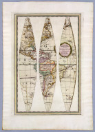
Cassini, Giovanni Maria
Full Title
Globo terrestre delineato sulle ultime osservazioni con i viaggi e nuove scoperte del Cap. Cook, inglese. In Roma, Presso la Calcograf(i)a Cam(era)le, 1790. Gia. Ma. Cassini, C.R.S. inc. (1792)
List No
5749.001
Note
Relief shown pictorially. First of 4 sheets of gores to make up a globe. Contains title and shows the Americas. The contemporary discoveries in the Pacific Ocean are shown in great detail with the courses of Cook's three voyages delineated. Cf: Library of Congress Geography and Map Division copy (G3201_B71_1790) on 5 sheets. Appeared in the author's Nuovo atlante geografico universale delineate suelle ultime osservazioni, Roma : Presso la Calcografia Camerale, 1792-1801.
Author
Cassini, Giovanni Maria
Full Title
(Globo terrestre delineato sulle ultime osservazioni con i viaggi e nuove scoperte del Cap. Cook, inglese. In Roma, Presso la Calcograf(i)a Cam(era)le, 1790). Gia. Ma. Cassini, Somco. inc. (1792)
List No
5749.002
Note
Relief shown pictorially. Second of 4 sheets of gores to make up a globe. Contains table and shows California and the Pacific. The contemporary discoveries in the Pacific Ocean are shown in great detail with the courses of Cook's three voyages delineated. Cf: Library of Congress Geography and Map Division copy (G3201_B71_1790) on 5 sheets. Appeared in the author's Nuovo atlante geografico universale delineate suelle ultime osservazioni, Roma : Presso la Calcografia Camerale, 1792-1801.
Author
Cassini, Giovanni Maria
Full Title
(Globo terrestre delineato sulle ultime osservazioni con i viaggi e nuove scoperte del Cap. Cook, inglese. In Roma, Presso la Calcograf(i)a Cam(era)le, 1790. Gia. Ma. Cassini, Somco. inc.) (1792)
List No
5749.003
Note
Relief shown pictorially. Third of 4 sheets of gores to make up a globe. Shows Asia and Australia. The contemporary discoveries in the Pacific Ocean are shown in great detail with the courses of Cook's three voyages delineated. Cf: Library of Congress Geography and Map Division copy (G3201_B71_1790) on 5 sheets. Appeared in the author's Nuovo atlante geografico universale delineate suelle ultime osservazioni, Roma : Presso la Calcografia Camerale, 1792-1801.
Author
Cassini, Giovanni Maria
Full Title
(Globo terrestre delineato sulle ultime osservazioni con i viaggi e nuove scoperte del Cap. Cook, inglese. In Roma, Presso la Calcograf(i)a Cam(era)le, 1790. Gia. Ma. Cassini, Somco. inc.) (1792)
List No
5749.004
Note
Relief shown pictorially. Fourth of 4 sheets of gores to make up a globe. Shows Europe, Africa and part of Asia. The contemporary discoveries in the Pacific Ocean are shown in great detail with the courses of Cook's three voyages delineated. Cf: Library of Congress Geography and Map Division copy (G3201_B71_1790) on 5 sheets. Appeared in the author's Nuovo atlante geografico universale delineate suelle ultime osservazioni, Roma : Presso la Calcografia Camerale, 1792-1801.
Author
Cassini, Giovanni Maria
Full Title
(Ring sheet for) (Globo terrestre delineato sulle ultime osservazioni con i viaggi e nuove scoperte del Cap. Cook, inglese. In Roma, Presso la Calcograf(i)a Cam(era)le, 1790). Gia. Ma. Cassini, Som. inc. (1792)
List No
5749.005
Note
"Ring sheet" of zodiacs and 2 polar calottes for mounting on globe furniture. Cf: Library of Congress Geography and Map Division copy (G3201_B71_1790) on 5 sheets. Appeared in the author's Nuovo atlante geografico universale delineate suelle ultime osservazioni, Roma : Presso la Calcografia Camerale, 1792-1801.
Author
Cassini, Giovanni Maria
Full Title
Globo Celeste calcolato peril corrente anno sulle osservazioni de Sigg. Flamsteed e de la Caille. Roma : Calc(ografi)a Cam(era)le, 1792. Inciso dal P. Gio. Ma. Cassini, C.R.S.
List No
5750.001
Note
Relief shown pictorially. First of 4 sheets of gores to make up a globe. Features a particularly decorative projection of the heavens and is attractively colored, with the constellations shown in their classical forms. Appeared in the author's Nuovo atlante geografico universale delineate suelle ultime osservazioni, Roma : Presso la Calcografia Camerale, 1792-1801.
Author
Cassini, Giovanni Maria
Full Title
(Globo Celeste calcolato peril corrente anno sulle osservazioni de Sigg. Flamsteed e de la Caille. Roma : Calc(ografi)a Cam(era)le, 1792. Inciso dal P. Gio. Ma. Cassini, C.R.S.)
List No
5750.002
Note
Relief shown pictorially. Second of 4 sheets of gores to make up a globe. Includes legend "Grandezze delle Stelle." Features a particularly decorative projection of the heavens and is attractively colored, with the constellations shown in their classical forms. Appeared in the author's Nuovo atlante geografico universale delineate suelle ultime osservazioni, Roma : Presso la Calcografia Camerale, 1792-1801.
Author
Cassini, Giovanni Maria
Full Title
(Globo Celeste calcolato peril corrente anno sulle osservazioni de Sigg. Flamsteed e de la Caille. Roma : Calc(ografi)a Cam(era)le, 1792. Inciso dal P. Gio. Ma. Cassini, C.R.S.)
List No
5750.003
Note
Relief shown pictorially. Third of 4 sheets of gores to make up a globe. Includes I Gemelli, Il Cancro and Il Leone. Features a particularly decorative projection of the heavens and is attractively colored, with the constellations shown in their classical forms. Appeared in the author's Nuovo atlante geografico universale delineate suelle ultime osservazioni, Roma : Presso la Calcografia Camerale, 1792-1801.
Author
Cassini, Giovanni Maria
Full Title
(Globo Celeste calcolato peril corrente anno sulle osservazioni de Sigg. Flamsteed e de la Caille. Roma : Calc(ografi)a Cam(era)le, 1792. Inciso dal P. Gio. Ma. Cassini, C.R.S.)
List No
5750.004
Note
Relief shown pictorially. Fourth of 4 sheets of gores to make up a globe. Includes I Pesci, L'Ariete and Il Toro. Features a particularly decorative projection of the heavens and is attractively colored, with the constellations shown in their classical forms. Appeared in the author's Nuovo atlante geografico universale delineate suelle ultime osservazioni, Roma : Presso la Calcografia Camerale, 1792-1801.
Author
Cassini, Giovanni Maria
Full Title
(Ring sheet for) (Globo Celeste calcolato peril corrente anno sulle osservazioni de Sigg. Flamsteed e de la Caille. Roma : Calc(ografi)a Cam(era)le, 1792). Gio. Ma. Cassini, Somco. inc.
List No
5750.005
Note
"Ring sheet" of zodiacs and 2 polar calottes for mounting on globe furniture. Appeared in the author's Nuovo atlante geografico universale delineate suelle ultime osservazioni, Roma : Presso la Calcografia Camerale, 1792-1801.
|