Author
Jefferys, Thomas
Full Title
(Title Page to) The natural and civil history of the French dominions in North and South America. Giving a particular account of the climate, soil, minerals, animals, vegetables, manufactures, trade, commerce, and languages ... Illustrated by maps and plans of the principal places, collected from the best authorities, and engraved by T. Jefferys, Geographer to his Royal Highness the Prince of Wales. Part I. Containing a description of Canada and Louisiana. London, Printed for Thomas Jefferys at Charing-Cross. MDCCLX.
List No
4796B
Note
Printed in red and black.
Author
Jefferys, Thomas
Full Title
A map of Canada and the north part of Louisiana with the adjacent countrys. By Thos. Jefferys, Geographer to His Royal Highness the Prince of Wales. T. Jefferys sculp. (1760)
List No
4796.001
Note
Engraved map. Relief shown pictorially. Shows Indian tribes, fishing banks, etc. Includes descriptive notes. Prime meridian: Ferro.
Author
Jefferys, Thomas
Full Title
A plan of the city of Quebec, the capital of Canada, as it surrendered 18 Septembr. 1759 to the British fleet and army commanded by Vice Adml. Saunders & Brigadr. Genl. Townshend. Published according to act of Parliament Janry. 15, 1760 by Thos. Jefferys at Charing Cross. Price 2 s.
List No
4796.002
Note
Engraved map. Relief shown by hachures. Shows buildings, fortifications, "St. Laurence or the Great River called by the Indians Hoshelaga or Canada River," etc. Oriented with north toward upper right.
Author
Jefferys, Thomas
Full Title
Plan of the town and fortifications of Montreal or Ville Marie in Canada. Published by Thos. Jefferys, Geographer to His Royal Highness the Prince of Wales at Charing Cross, Jan 30, 1758. Price 2s. (1760)
List No
4796.003
Note
Engraved map. Shows buildings, fields, etc. Oriented with north toward upper right.
Author
[Jefferys, Thomas, Holland, Samuel, 1728-1801]
Full Title
A new map of Nova Scotia and Cape Britain, with the adjacent parts of New England and Canada, composed from a great number of actual surveys, and other materials regulated by many new astronomical observations of the longitude as well as latitude; with an explanation. 1755 published according to Act of Parliament by Thos. Jefferys, Geographer to His Royal Highness the Prince of Wales at the corner of St. Martins Lane, Charing Cross, London. (1760)
List No
4796.004
Note
Engraved map. Borders hand col. Relief shown pictorially. Shows Indian tribes, fishing banks, roads with distances, etc. Prime meridian: Ferro.
Author
[Gridley, Richard, Jefferys, Thomas]
Full Title
A plan of the city and fortifications of Louisburg; from a survey made by Richard Gridley, Lieut. Coll. of the Train of Artillery in 1745. ... A plan of the city and harbour of Louisburg with the French batteries that defended it and those of the English, shewing that part of Gabarus Bay in which they landed, and the ground on which they encamped during the siege in 1758. (with) A map of Gabarus Bay, adjoining Louisburg. Published by Thos. Jefferys, Geographer to the Prince of Wales at Charing Cross, Octobr. 9, 1758. Price 2s.
List No
4796.005
Note
Two engraved maps on 1 sheet, with inset. Relief shown by hachures; depths by soundings. City plan shows buildings, etc. Includes profile. "Harbour" map at (ca. 1:21,000) scale; Gabarus Bay map at (ca. 1:150,000) scale.
Author
[Gridley, Richard, Jefferys, Thomas]
Full Title
An authentic plan of the River St. Laurence from Sillery to the Fall of Montmorenci, with the operations of the Siege of Quebec under the command of Vice-Adml. Saunders & Major Genl. Wolfe down to the 5. Septr. 1759. Drawn by a captain in his majesties navy. (with) A view of the action gained by the English Sepr. 13, 1759 near Quebec, brought from thence by an officer of distinction. (with) Part of the upper river of St. Laurence.
List No
4796.006
Note
Engraved map with 2 insets. Relief shown by hachures. Oriented with north toward upper right. Includes dedication to William Pitt.
Author
[Anville, Jean Baptiste Bourguignon d, 1697-1782, Jefferys, Thomas]
Full Title
North America from the French of Mr. d'Anville, improved with the back settlements of Virginia and course of Ohio. Illustrated with geographical and historical remarks. 1755 published according to Act by Thos. Jefferys Geographer to His Royal Highness the Prince of Wales near Charing Cross. (1760)
List No
4796.007
Note
Engraved map. Relief shown pictorially. Shows Indian tribes, etc. Prime meridians: Ferro and London.
Author
[Brion de la Tour, Louis, Jefferys, Thomas]
Full Title
Plan of New Orleans the capital of Louisiana; with the disposition of its quarters and canals as they have been traced by Mr. de la Tour in the year 1720. (with) The course of Mississipi River from Bayagoulas to the sea. (with) The east mouth of the Mississipi, with the plan of Fort la Balise which defends the entrance and channel of that river. Nov: 1759, published according to Act of Parliament by T. Jefferys at Charing Cross. Price 2 s.
List No
4796.008
Note
Engraved map with 2 insets. Shows buildings, gardens, lots, magazines, vegetated areas, etc. Scales of inset maps (ca. 1:800,000) and (ca. 1:40,000).
Author
Jefferys, Thomas
Full Title
The West Indies exhibiting the English, French, Spanish, Dutch & Danish settlements. Collected from the best authorities by Thomas Jefferys, Geographer to His Royal Highness the Prince of Wales. Published according to the Act by Thos. Jefferys, Geographer to His Royal Highness the Prince of Wales near Charing Cross. (1760)
List No
4796.009
Note
Engraved map. Relief shown pictorially. Includes illustrated cartouche. Prime meridians: Ferro and London.
Author
Jefferys, Thomas
Full Title
The island of Hispaniola called by the French St. Domingo. Subject to France & Spain, from the best authorities by Thomas Jefferys, Geographer to His Royal Highness the Prince of Wales. T. Jefferys sculp. (1760)
List No
4796.010
Note
Engraved map. Relief shown pictorially.
Author
Jefferys, Thomas
Full Title
An authentic plan of the town and harbour of Cap Francois in the isle of St. Domingo. By Thomas Jefferys, Geographer to His Royal Highness, the Prince of Wales. (1760)
List No
4796.011
Note
Engraved map. Relief shown by hachures; depths by soundings. Oriented with north toward right.
Author
Jefferys, Thomas
Full Title
Guadaloupe, one of the Caribbee islands subject to France in the West Indies, from the best authorities by T. Jefferys. Published by T. Jefferys at Charing Cross. (1760)
List No
4796.012
Note
Engraved map. Relief shown pictorially and by hachures. Ornamental cartouche. Prime meridian: Ferro.
Author
Jefferys, Thomas
Full Title
Plan of the town of Basse Terre, the capital of Guadaloupe from an authentic survey. Published by Thos. Jefferys Geographer to his Royal Highness the Prince of Wales, near Charing Cross, London. T. Jefferys sculp. (1760)
List No
4796.013
Note
Engraved map. Relief shown by hachures. Shows buildings, fortifications, fields, etc. Oriented with north toward upper left.
Author
[Houel, Jean Pierre Louis Laurent, 1735-1813, Jefferys, Thomas]
Full Title
Martinico, one of the Caribbee Islands, in the West Indies; subject to the French, according to the observations of Mr. Houel, Engineer. By Thos. Jefferys, Geographer to His Royal Highness the Prince. Published by Thos. Jefferys near Charing Cross, London.
List No
4796.014
Note
Engraved map. Relief shown by hachures; depths by soundings. Shows habitation or plantations, sugar works, oxen and water mills, observations points, etc. Prime meridian: Ferro.
Author
Caylus, Anne Claude Philippe, comte de, 1692-1765
Full Title
Plan of the town and citadel of Fort Royal the capital of Martinico with the bay of Cul de Sac Royal. By Mr. de Caylus, Engineer General of the French Islands. (1760)
List No
4796.015
Note
Engraved map. Relief shown by hachures; depths by soundings. Includes inset map.
Author
[Caylus, Anne Claude Philippe, comte de, 1692-1765, Jefferys, Thomas]
Full Title
Plan of the town and fort of Grenada, by Mr. de Caylus, Engineer General of the French Islands. (with) The Isle of Grenada. T. Jefferys, sculp. (1760)
List No
4796.016
Note
Engraved map with inset. Relief shown by hachures; depths by soundings. Shows buildings, fortifications, etc.
Author
Jefferys, Thomas
Full Title
The island and colony of Cayenne subject to the French on the continent of South America. By Thomas Jefferys, Geographer to His Royal Highness the Prince of Wales. T. Jefferys sculp.
List No
4796.017
Note
Engraved map. Relief shown by hachures; depths by soundings. Shows sugar works, coffee and Rocou plantations, Indian tribes, etc.
Author
[Jefferys, Thomas, Marchais, R. de]
Full Title
Plan of the town of Cayenne and Fort St. Michael. Drawn by the Chevalier de Mareechais. T. Jefferys sculp. (1760)
List No
4796.018
Note
Engraved map. Relief shown by hachures. Shows named streets, buildings, fortifications, "The Kings Garden where they grow coffee trees," "drowned land with mangrove trees," etc.
Author
Dangeau, abbe de, 1643-1723
Full Title
(Covers to) Nouvelle metode pour aprende facilement et sans maitre la geografie, et les premers principes du Blazon ... Compose par M. L'abbe de Dangeau, l'un des quarante de l'academie Francoise. 1693. (On cover) Cette geographie de la France par l'Abbe de Dangeau est le manuscript de l'auteur.
List No
3658A
Note
Bound in full dark green leather covered boards with title and ornate border embossed in gold; the spine is stamped with "Geographie de la France par l'Abbe de Dangeau 74. Cartes, 38 Planches."
Author
Dangeau, abbe de, 1643-1723
Full Title
(Text Page to) Nouvelle metode pour aprende facilement et sans maitre la geografie, et les premers principes du Blazon ... Compose par M. L'abbe de Dangeau, l'un des quarante de l'academie Francoise. 1693.
List No
3658B
Note
Pen-and-ink. "Mr. Louis de Courcillon de Dangeau, qui est mort en 1723 ... Extrait de la Bibliotheque de la France par Jacques Le Long edition de foulette 1er. vol. no. 599."
Author
Dangeau, abbe de, 1643-1723
Full Title
(Title Page to) Nouvelle metode pour aprende facilement et sans maitre la geografie, et les premers principes du Blazon ... Compose par M. L'abbe de Dangeau, l'un des quarante de l'academie Francoise. 1693. (On cover) Cette geographie de la France par l'Abbe de Dangeau est le manuscript de l'auteur.
List No
3658C
Note
Pen-and-ink. A large atlas of outline maps by Dangeau, perhaps some of the earliest examples of outline maps used for teaching geography. This copy was put together by Dangeau. The maps were probably issued separately, and this atlas is one of the few bound copies. A note in French opposite the manuscript title page says that Buache had examples of these maps in his library. Some additions to the book were made by an owner subsequent to Dangeau's death in 1723. This copy was in the Phillipps Manuscript collection (no. 24790) and was sold by Sotheby's in 1903 and 1919. Of the 80 maps, 36 are 18 sets of 2 maps each, one a regular map and the other with blanks to be filled in by the student, with the regular maps having flaps on both sides with explanatory text; these maps teach basic notions of geography of the World, Europe, and France. 23 maps present administrative, both civic and ecclesiastical, divisions of France. 21 maps are of the countries which then formed the Holy Roman Empire of Germany, in the same manner as the maps of France. There are also 44 tables illustrating the history and genealogy of the French dynasties; four of these tables are beautiful illustrations of coats of arms. The atlas is bound in full dark green leather covered boards with title and ornate border embossed in gold; the spine is stamped with "Geographie de la France par l'Abbe de Dangeau 74. Cartes, 38 Planches."
Author
Dangeau, abbe de, 1643-1723
Full Title
(Contents to) Nouvelle metode pour aprende facilement et sans maitre la geografie, et les premers principes du Blazon ... Compose par M. L'abbe de Dangeau, l'un des quarante de l'academie Francoise. 1693.
List No
3658D
Note
Pen-and-ink. "Table" of contents, 1st page.
Author
Dangeau, abbe de, 1643-1723
Full Title
(Contents to) Nouvelle metode pour aprende facilement et sans maitre la geografie, et les premers principes du Blazon ... Compose par M. L'abbe de Dangeau, l'un des quarante de l'academie Francoise. 1693.
List No
3658E
Note
Pen-and-ink. "Table" of contents, 2nd-3rd pages.
Full Title
Chronologie des rois de France. 1755 (i.e. 1775?)
List No
3658F
Note
Pen-and-ink. Chronological chart covering the period 420-1774. "Voyez leurs portraits, feuille 74."
Full Title
Principes du blazon 1re. table. (1693)
List No
3658G
Note
Pen-and-ink and color. Sheet of text affixed at right. Drawings of coats of arms. Sheet 3 entitled: Principes du blason.
Full Title
Principes du blazon 2e. table. (1693)
List No
3658H
Note
Pen-and-ink and color. Drawings of coats of arms.
Full Title
Principes du blason 3e. table. (1693)
List No
3658I
Note
Pen-and-ink and color. Drawings of coats of arms. Sheets 1-2 entitled: Principes du Blazon.
Full Title
Planisfere ou Mapemonde. Ce que c'est que la Mapemonde. Division du globe en terres conues, terres inconnue & mers. (1693)
List No
3658.001
Note
Engraved double hemisphere map. Hand colored. Column of text at left. Shows California as an island. Sheet number from verso.
Full Title
Planisfere ou Mapemonde. (1693)
List No
3658.002
Note
Engraved double hemisphere map. Hand colored. Outline map showing shorelines and divisions of continents only. Shows California as an island. Sheet number from verso.
Full Title
Planisfere ou Mapemonde. Division de la Terre en 4. parties. (1693)
List No
3658.003
Note
Engraved double hemisphere map. Hand colored. Shows shorelines and continental boundaries with continental and ocean names only. Column of text at left. Shows California as an island. Sheet number from verso.
Full Title
Planisfere ou Mapemonde. (1693)
List No
3658.004
Note
Engraved double hemisphere map. Hand colored. Outline map showing shorelines and continental boundaries. Shows California as an island. Sheet number from verso.
Full Title
Planisfere ou Mapemonde. Du cours du Soleil. Des points cardinaus. (1693)
List No
3658.005
Note
Engraved double hemisphere map. Hand colored. Shows equator, tropic of Cancer, tropic of Capricorn, poles, shorelines and continental boundaries. Column of text at left. Shows California as an island. David Rumsey Collection copy has additions in pen-and-ink. Sheet number from verso.
Full Title
Planisfere ou Mapemonde. (1693)
List No
3658.006
Note
Engraved double hemisphere map. Hand colored. Shows Equator, tropic of Cancer, tropic of Capricorn, poles, shorelines and continental boundaries. Column of text at left. Shows California as an island. Sheet number from verso.
Full Title
Planisfere ou Mapemonde divisee en cinq zones. (1693)
List No
3658.007
Note
Engraved double hemisphere map. Hand colored. Shows five climatic zones. Column of text at left. Shows California as an island. Sheet number from verso.
Full Title
Planisfere ou Mapemonde (divisee en cinq zones. 1693)
List No
3658.008
Note
Engraved double hemisphere map. Outline map with continental boundaries hand colored. Climatic zones to be filled in by student. Shows California as an island. Sheet number from verso.
Full Title
Planisfere ou Mapemonde avec les degrez de latitude & de longitude. (1693)
List No
3658.009
Note
Engraved double hemisphere map. Continental boundaries hand colored. Shows lines of latitude and longitude and coastlines. Only the Cape of Good Hope and Canary Islands are named. Prime meridian: Ferro. Column of text at left. Shows California as an island. Sheet number from verso.
Full Title
Planisfere ou Mapemonde avec les degrez de latitude & de longitude. (1693)
List No
3658.010
Note
Engraved double hemisphere map. Continental boundaries hand colored. Shows lines of latitude and longitude and coastlines. Like sheet M5 but without coordinate numbering, place names and text. Prime meridian: Ferro. Shows California as an island. Sheet number from verso.
Full Title
Confins (de la France). Avec privilege du Roi. (1693)
List No
3658.011
Note
Engraved map. Boundaries in outline color. Has names of countries and water bodies, and columns of text in right and left margins. The title "Confins" on verso. Sheet number from verso. With revisions of 1754 in pen-and-ink.
Full Title
Confins (de la France. 1693)
List No
3658.012
Note
Engraved map. Boundaries in outline color. Outline map: names of countries and water bodies to be filled in by student. The title "Confins" on verso. Sheet number from verso.
Full Title
L'Europe avec les confins. (1693)
List No
3658.013
Note
Engraved map. Continental boundaries hand colored. Includes column of text at left. On verso "E 1" and "8 ."
Full Title
(L'Europe avec les confins. 1693)
List No
3658.014
Note
Engraved map. Continental boundaries hand colored. Outline map to be filled in by student. On verso "E 1 R" and "9 ."
Full Title
Nom, maison, religion, etc. des souverains qui regnent en Europe. En Janvier 1695.
List No
3658.015
Note
Engraved map. Continental boundaries and Western European boundaries hand colored. Only place names are for some Western European countries. Includes column of text at left. On verso "E 2" and "10 ."
Full Title
(Nom, maison, religion, etc. des souverains qui regnent en Europe. 1695?)
List No
3658.016
Note
Engraved map. Continental boundaries and Western European boundaries hand colored. Outline map to be filled in by student. On verso "E 2 R" and "11 ."
Full Title
L'Europe. (Nom, maison, religion, etc. des souverains). 1755.
List No
3658.017
Note
Engraved map. Country boundaries hand colored. Has country names for Central, Northern and eastern Europe. Includes column of text at left. On verso "E 3" and "12 ." David Rumsey Collection copy: has pen-and-ink revisions to text, 1755.
Full Title
L'Europe. (Nom, maison, religion, etc. des souverains. 1695?)
List No
3658.018
Note
Engraved map. Country boundaries hand colored. Outline map to be filled in by student. On verso "E 3 R" and "13 ."
Full Title
L'Europe. (Nom, maison, religion, etc. des souverains). 1755.
List No
3658.019
Note
Engraved map. Country boundaries hand colored. Has country and island names for Southern Europe and Southern Russia. Includes column of text at left. On verso "E 4" and "14 ." David Rumsey Collection copy: has revisions in pen-and-ink to 1755.
Full Title
L'Europe. (Nom, maison, religion, etc. des souverains. 1695?)
List No
3658.020
Note
Engraved map. Country boundaries hand colored. Outline map to be completed to student. On verso "E 4 R" and "15 ."
Full Title
L'Europe avec les viles capitales des principales souverainetez. (1693)
List No
3658.021
Note
Engraved map. Country boundaries hand colored. Shows major cities with names. Includes column of text at left. On verso "E 5" and "16 ."
Full Title
L'Europe (avec les viles capitales des principales souverainetez. 1693)
List No
3658.022
Note
Engraved map. Country boundaries hand colored. Outline map showing location of major cities; to be filled in by student. On verso "E 5 R" and "17 ."
Full Title
L'Europe avec trois mers, trois fleuves & trois chaines de montagnes qui sont comunes a plus d'un pays. (1693)
List No
3658.023
Note
Engraved map. Country boundaries hand colored. Relief shown pictorially. Includes column of text at left. On verso "E 6" and "18 ."
Full Title
L'Europe (avec trois mers, trois fleuves & trois chaines de montagnes qui sont comunes a plus d'un pays. 1693)
List No
3658.024
Note
Engraved map. Country boundaries hand colored. Relief shown pictorially. Outline map to be filled in by student. On verso "E 6 R" and "19 ."
Full Title
L'Europe (division des vents. 1693)
List No
3658.025
Note
Engraved map. Country boundaries hand colored. Relief shown pictorially. Includes columns of text in side margins. On verso "E7" and "20 ."
Full Title
L'Europe (division des vents. 1693)
List No
3658.026
Note
Engraved map. Country boundaries hand colored. Relief shown pictorially. Outline map to be filled in by student. On verso "E7 R" and "21 ."
Full Title
Provinces (France. 1693)
List No
3658.027
Note
Engraved map. Province boundaries hand colored. Prime meridian: Ferro. On verso "22."
Full Title
(Provinces France. 1693)
List No
3658.028
Note
Engraved map. Province boundaries hand colored. Outline map to be filled in by student. Prime meridian: Ferro. On verso "23."
Full Title
Capitales des provinces (France). Avec privilege du Roi. (1693)
List No
3658.029
Note
Engraved map. Province boundaries hand colored. Shows names and locations of capitals. Prime meridian: Ferro. On verso "24" and title "Capitales des provinces."
Full Title
Capitales des provinces (France. 1693)
List No
3658.030
Note
Engraved map. Province boundaries hand colored. Outline map showing locations of capitals; to be filled in by student. Prime meridian: Ferro. On verso "25" and title "Capitales des provinces."
Full Title
Subdivisions de quelques provinces (France). Avec privilege du Roi. (1693)
List No
3658.031
Note
Engraved map. Province and subdivision boundaries hand colored. Prime meridian: Ferro. On verso "26" and title "Subdivisions de quelques provinces."
Full Title
Gouvernemens de provinces (France. 1693)
List No
3658.032
Note
Engraved map. Boundaries hand colored. Prime meridian: Ferro. Columns of text in side margins. On verso "27" and title "Gouvernemens de provinces."
Full Title
Table alfabetique des gouvernemens de province avec le nom de ceux qui en sont gouverneurs au commencement de l'annee 1693.
List No
3658J
Note
Engraved table in two columns. On verso "28." David Rumsey Collection copy: has revisions in pen-and-ink.
Full Title
(Subdivisions de quelques provinces, France). Avec privilege du Roi. (1693)
List No
3658.033
Note
Engraved map. Province and subdivision boundaries hand colored. Outline map to be filled in by student. Prime meridian: Ferro. On verso "29."
Full Title
Grandes rivieres qui se jettent dans la mer (France). Avec privilege du Roi. (1693)
List No
3658.034
Note
Engraved map. Province and subdivision boundaries hand colored. Shows city and river names. Includes columns of text in side margins and blank ornamental cartouche. Prime meridian: Ferro. On verso "30" and title "Grandes rivieres qui se jettent dans la mer."
Full Title
Grandes rivieres qui se jettent dans la mer (France. 1693)
List No
3658.035
Note
Engraved map. Province and subdivision boundaries hand colored. Outline map showing locations of cities and rivers; to be filled in by student. Prime meridian: Ferro. On verso "31" and title "Grandes rivieres qui se jettent dans la mer."
Full Title
Petites rivieres qui se jettent dans la mer (France). Avec privilege du Roi. (1693)
List No
3658.036
Note
Engraved map. Province and subdivision boundaries hand colored. Shows city and river names. Prime meridian: Ferro. On verso "32."
Full Title
Petites rivieres qui se jettent dans la mer (France. 1693)
List No
3658.037
Note
Engraved map. Province and subdivision boundaries hand colored. Outline map showing location of cities and rivers; to be filled in by student. Prime meridian: Ferro. On verso "33" and title "Petites rivieres qui se jettent dans la mer."
Full Title
Rivieres qui se jettent dans les 6. grandes (France). Avec privilege du Roi. (1693)
List No
3658.038
Note
Engraved map. Province and subdivision boundaries hand colored. Shows city and river names. Prime meridian: Ferro. On verso "34" and title "Rivieres qui se jettent dans les 6. grandes."
Full Title
Rivieres qui se jettent dans les 6. grandes (France. 1693)
List No
3658.039
Note
Engraved map. Province and subdivision boundaries hand colored. Outline map showing city and river names; to be filled in by student. Prime meridian: Ferro. On verso "35" and title "Rivieres qui se jettent dans les 6. grandes."
Full Title
(Archevechez et Evechez de France). Avec privilege du Roi. (1693)
List No
3658.040
Note
Engraved map. Boundaries hand colored. Prime meridian: Ferro. Columns of text in side margins. On verso "36."
Full Title
Archevechez & Evechez (France). Avec privilege du Roi. (1693)
List No
3658.041
Note
Engraved map. Boundaries hand colored. Includes ornamental cartouche. Prime meridian: Ferro. On verso "37" and title "Archevechez et Evechez."
Full Title
Droits par les quels le Roi nomme aux evechez (France). Avec privilege du Roi. (1693)
List No
3658.042
Note
Engraved map. Hand colored. Includes columns of text in side margins. Prime meridian: Ferro. On verso "38" and title "Droits par les quels le Roi nomme aux evechez."
Full Title
Comment le Pape & le Roi font un eveque (France). Avec privilege du Roi. (1693)
List No
3658.043
Note
Engraved map. Hand colored. Includes columns of text in side margins. Prime meridian: Ferro. On verso "39" and title "Comment le Pape & le Roi font un eveque."
Full Title
Assemblee du clerge (France). Avec privilege du Roi. (1693)
List No
3658.044
Note
Engraved map. Hand colored. Includes columns of text in side margins. Prime meridian: Ferro. On verso "40" and title "Assemblee du clerge."
Full Title
Plan de la seance de l'Assemblee du clerge en 1680. (1693)
List No
3658K
Note
Engraved drawing showing large room with tables and chairs. Includes descriptive notes. Columns of text "Journal abrege de l'Assemblee du Clerge de l'annee 1680 in side margins. On verso "41" and title "Plan de la seance de l'Assemblee du clerge en 1680."
Full Title
Bureaux diocesains & chambres souveraines (France). Avec privilege du Roi. (1693)
List No
3658.045
Note
Engraved map. Hand colored. Includes columns of text in side margins. Prime meridian: Ferro. On verso "42" and title "Bureaux diocesains & chambres souveraines ."
Full Title
Generalites eclesiastiques (France). Avec privilege du Roi. (1693)
List No
3658.046
Note
Engraved map. Hand colored. Includes columns of text in side margins. Prime meridian: Ferro. On verso "43." David Rumsey Collection copy: with title and additions in pen-and-ink at left.
Full Title
Etablissement des evechez & des provinces eclesiastiques (France). Avec privilege du Roi. (1693)
List No
3658.047
Note
Engraved map. Hand colored. Includes columns of text in side margins. Prime meridian: Ferro. On verso "44" and title "Etablissement des evechez & des provinces eclesiastiques."
Author
Chevillard, J. (Jacques)
Full Title
La France chretienne divisee en archevechee et evechee et les armes des archevesques et evesques de France vivans et l'annee 1690, par les soins du Sr. Chevillard. A Paris, chez J. Moncornet, rue St. Jacques a la Felicite. C.P.R. (1693)
List No
3658.048
Note
Engraved chart of coats of arms with small map at center. Hand colored. On verso "45."
Full Title
Parlemens (France). Avec privilege du Roi. (1693)
List No
3658.049
Note
Engraved map. Boundaries hand colored. Prime meridian: Ferro. On verso "46" and title "Parlemens."
Full Title
Presidiaus (France). Avec privilege du Roi. (1693)
List No
3658.050
Note
Engraved map. Boundaries hand colored. Prime meridian: Ferro. On verso "47" and title "Presidiaus."
Full Title
(Table des parlemens, France). Avec privilege du Roi. (1693)
List No
3658L
Note
Engraved table of administrative divisions. Title from verso. Columns headed: Parlemens, Chambres, 1rs. Presidens, Presidens a Mortier, Conseillers, Gens du Roi, Provinces, Presidiaus, Bailliages et Senechaucees, Tems de la Creation. On verso "48."
Full Title
Generalitez & elections (France). (title in cartouche) Il y a dans le Royaume 25 Generalitez & elections ... Avec privilege du Roi. (1693)
List No
3658.051
Note
Engraved map. Boundaries hand colored. Includes note. Prime meridian: Ferro. On verso "49" and title "Generalitez & elections."
Full Title
Tems de la creation des Generalitez (France). Avec privilege du Roi. (1693)
List No
3658.052
Note
Engraved map. Boundaries hand colored. Columns of text in side margins. Prime meridian: Ferro. On verso "50" and title "Generalitez & elections."
Full Title
Intendances (France). Avec privilege du Roi. (1693)
List No
3658.053
Note
Engraved map. Hand colored. Column of text in left margin. Prime meridian: Ferro. On verso "51" and title "Intendances."
Full Title
Tailles (France). Avec privilege du Roi. (1693)
List No
3658.054
Note
Engraved map. Hand colored. Column of text in left margin. Prime meridian: Ferro. On verso "52" and title "Tailles."
Full Title
Cours des aides (France). (title in cartouche) Il y a dans le Royaume 5. Cours des Aides outre Parlemens & Chambres des Contes qui sont la fonction de Cour des Aides ... Avec privilege du Roi. (1693)
List No
3658.055
Note
Engraved map. Hand colored. Prime meridian: Ferro. On verso "53" and title "Cours des aides."
Full Title
(Table des cours des aides, France). (1693)
List No
3658M
Note
Engraved table. Title from verso. On verso "54."
Full Title
Duchez & pairies (France). Avec privilege du Roi. (1693)
List No
3658.056
Note
Engraved map. Hand colored. Prime meridian: Ferro. On verso "55" and title "Duchez & pairies."
Full Title
Departement des quatre secretaires d'etat (France). (Title in upper margin) Departemens des 4. secretaires d'etat. Avec privilege du Roi. (1693)
List No
3658.057
Note
Engraved map. Hand colored. Includes table and text. Prime meridian: Ferro. On verso "56" and title "Departemens des 4. secretaires d'etat."
Full Title
Etats Generaus (France). (in ornamental cartouche) On voit dans cette cartes les noms de provinces des Senechaussees, des Bailliages et des Viles qui envoient des deputez aux Etats Generaus ... Grave par Liebaux. (1693)
List No
3658.058
Note
Engraved map. Hand colored. Includes notes. Columns of text in side margins. Prime meridian: Ferro. On verso "57" and title "Etats Generaus."
Full Title
Eaux & forets (France). (title in ornamental cartouche) On voit dans cette carte les 16. departemens des grand Maitres des Eaux et Forets, avec les provinces et les Maitrises particulieres qu'il y a en chaque departement selon l'edit donne par le Roi en Fevrier 1689, et selon l'edit donne par le Roi en Novembre 1689. (1693?)
List No
3658.059
Note
Engraved map. Hand colored. Prime meridian: Ferro. On verso "58" and title "Eaux & forets."
Full Title
Academies & universitez (France. 1693?)
List No
3658.060
Note
Engraved map. Hand colored. Includes note on the Academie Francaise in an ornamental cartouche, and notes about and seals of other academies in France. Prime meridian: Ferro. David Rumsey Collection copy: has "Dijon Universite" added in pen-and-ink. On verso "59" and title "Academies & universitez."
Full Title
Table genealogique de la troisieme race des rois de France, ou l'on voit les principales branches qui en sont sorties. Avec privilege du Roi. (1693)
List No
3658N
Note
Engraved genealogical chart. From Robert le Fort to Louis 14. le Grand. On verso "60" and title "Table genealogique de la 3me race." David Rumsey Collection copy: has additions in red ink.
Full Title
Table genealogique de la troisieme race des rois de France, ou l'on voit les provinces & principales viles qui sont revenues a la courone sous chacun de ces rois. Avec privilege du Roi. (1693)
List No
3658O
Note
Engraved genealogical chart. From Robert le Fort to Louis 14. le Grand. On verso "61" and title "Table genealogique de la 3me race." David Rumsey Collection copy: has additions in red ink.
Full Title
Table genealogique de la troisieme race des rois de France, ou l'on voit enquette annee chacun deux a commence a regner. Avec privilege du Roi. (1693)
List No
3658P
Note
Engraved genealogical chart. Hand colored. From Robert le Fort to Louis 14. le Grand. On verso "62" and title "Table genealogique de la 3me race."
Full Title
Table genealogique de la troisieme race des rois de France, ou l'on voit de quelle maniere ils ont succede les uns aux autres depuis l'an 987 jusqu'a present. Avec privilege du Roi. (1693)
List No
3658Q
Note
Engraved genealogical chart. From Robert le Fort to Louis 14. le Grand. On verso "63" and title "Table genealogique de la 3me race." David Rumsey Collection copy: has additions in red ink.
Full Title
(Table genealogique de la troisieme race des rois de France, detail par siecle). T. 1ere. (1693)
List No
3658R
Note
Engraved grid with pen-and-ink. Title from table of contents. On verso "64."
Full Title
(Table genealogique de la troisieme race des rois de France, detail par siecle). T. 2e. (1693)
List No
3658S
Note
Engraved grid with pen-and-ink. Title from table of contents. On verso "65."
Full Title
(Table genealogique de la troisieme race des rois de France, detail par siecle). T. 3e. (1693)
List No
3658T
Note
Engraved grid with pen-and-ink. Title from table of contents. On verso "66."
Full Title
(Table genealogique de la troisieme race des rois de France, detail par siecle). T. 4e. (1693)
List No
3658U
Note
Engraved grid with pen-and-ink. Title from table of contents. On verso "67."
Full Title
(Table genealogique de la troisieme race des rois de France, detail par siecle). T. 5e. (1693)
List No
3658V
Note
Engraved grid with pen-and-ink. Title from table of contents. On verso "68."
Full Title
(Table genealogique de la troisieme race des rois de France, detail par siecle). T. 6e. (1693)
List No
3658W
Note
Engraved grid with pen-and-ink. Title from table of contents. On verso "69."
Full Title
(Table genealogique de la troisieme race des rois de France, detail par siecle). T. 7e. (1693)
List No
3658X
Note
Engraved grid with pen-and-ink. Title from table of contents. On verso "70."
Full Title
(Table genealogique de la troisieme race des rois de France, detail par siecle). T. 8e. (1693)
List No
3658YA
Note
Engraved grid with pen-and-ink. Title from table of contents. On verso "71."
Full Title
(Table genealogique de la troisieme race des rois de France, detail par siecle). T. 9e. (1693)
List No
3658YB
Note
Engraved grid with pen-and-ink. Title from table of contents. On verso "72."
Full Title
(Table genealogique de la troisieme race des rois de France, detail par siecle). 10e. (1693)
List No
3658YC
Note
Engraved grid with pen-and-ink. Title from table of contents. On verso "73."
Full Title
Portraits des rois de France tires des plus belles medailles, le chifre qui est autour de chaque medaille marque l'annee ou chaque roi a commence a regner ... (1774?)
List No
3658.061
Note
Engraved chart with hand color. David Rumsey Collection copy has annotations in pen-and-ink; latest date is 1774.
Full Title
(Comment le Royaume le parlageoint dans la 1ere et dans la 2e race. 1693)
List No
3658YD
Note
Engraved table with pen-and-ink annotations. Title from table of contents. "Pour Mr. de L'ile." On verso "75."
Full Title
(Minorites et regences. 1693)
List No
3658YE
Note
Engraved table with pen-and-ink annotations. Title from table of contents. On verso "76."
Full Title
(Guerres. 1693)
List No
3658YF
Note
Engraved table with pen-and-ink annotations. Title from table of contents. On verso "77."
Full Title
De quelle maniere les rois de la 3e. race ont succede les uns aux autres. 1693)
List No
3658YG
Note
Engraved table with pen-and-ink annotations. On verso "78."
Full Title
Division des Poetes. (1693)
List No
3658YH
Note
Engraved table with pen-and-ink annotations. On verso "79."
Full Title
Division des Varron. (1693)
List No
3658YI
Note
Engraved table with pen-and-ink annotations. On verso "80."
Full Title
Epoques Romaines. (1693)
List No
3658YJ
Note
Engraved table with pen-and-ink annotations. On verso "81."
Full Title
Epoques Francoises. (1693)
List No
3658YK
Note
Engraved table with pen-and-ink annotations. On verso "82."
Full Title
(Division de l'aage du Monde. 1693)
List No
3658YL
Note
Engraved table with pen-and-ink annotations. Title from table of contents. On verso "83."
Full Title
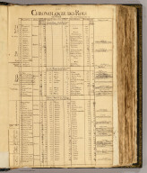
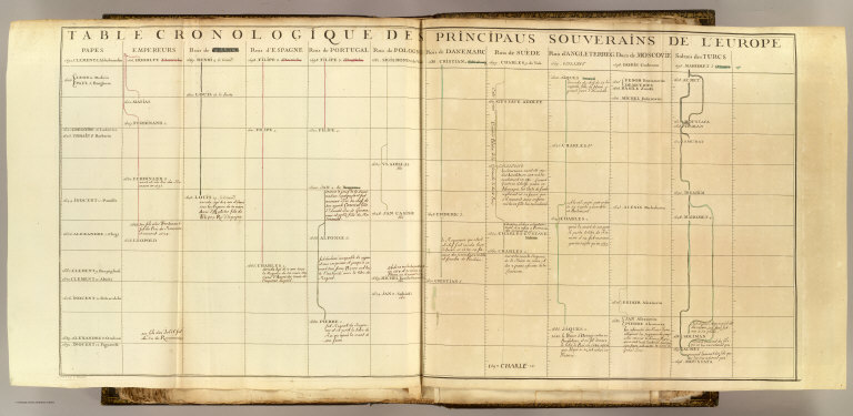
Table cronologique de principaus souverains de l'Europe. Grave par C. Vincent. (1697?)
List No
3658.062
Note
Engraved chart, hand colored. Latest date on chart is 1697. Has annotations in pen-and-ink. "84" on verso.
Full Title
(Chronologie de la Maison de Loraine. 1698?)
List No
3658.063
Note
Pen-and-ink chart, red and black. Latest date on chart is 1698. Small piece missing
Full Title
Le Duc d'Elbeuf, le nome Henri de Loraine. (1700?)
List No
3658YM
Note
Pen-and-ink. Page 1 of 4. Latest date in document (verso of page 2) is 1700.
Full Title
Le Duc d'Elbeuf, le nome Henri de Loraine. (1700?)
List No
3658YN
Note
Pen-and-ink. Page 2 of 4.
Full Title
Le Duc d'Elbeuf, le nome Henri de Loraine. (1700?)
List No
3658YO
Note
Pen-and-ink. Page 3 of 4.
Full Title
Le Duc d'Elbeuf, le nome Henri de Loraine. (1700?)
List No
3658YP
Note
Pen-and-ink. Page 4 of 4.
Full Title
Explication des armoiries de la Maison de Loraine. (1700?)
List No
3658YQ
Note
Pen-and-ink. Page 1 of 2.
Full Title
Explication des armoiries de la Maison de Loraine. (1700?)
List No
3658YR
Note
Pen-and-ink. Page 2 of 2.
Full Title
Le Comte d'Armagnac, le nome Louis de Loraine. (1700?)
List No
3658YS
Note
Pen-and-ink. Page 1 of 4.
Full Title
Le Comte d'Armagnac, le nome Louis de Loraine. (1700?)
List No
3658YT
Note
Pen-and-ink. Page 2 of 4.
Full Title
Le Comte d'Armagnac, le nome Louis de Loraine. (1700?)
List No
3658YU
Note
Pen-and-ink. Page 3 of 4.
Full Title
Le Comte d'Armagnac, le nome Louis de Loraine. (1700?)
List No
3658YV
Note
Pen-and-ink. Page 4 of 4.
Full Title
Frankreich. (Efter Stielers Hand-Atlas. Stockholm, J.L. Brudin, 1852)
List No
2605.010
Note
Engraved map. Outline hand coloring. Relief shown by hachures. In German. Prime meridian: Ferro.
Full Title
Italien. (Efter Stielers Hand-Atlas. Stockholm, J.L. Brudin, 1852)
List No
2605.011
Note
Engraved map. Outline hand coloring. Relief shown by hachures. In German. Prime meridian: Ferro.
Full Title
Die Brittischen Inseln. England, Schottland, Ireland. (Efter Stielers Hand-Atlas. Stockholm, J.L. Brudin, 1852)
List No
2605.012
Note
Engraved map. Outline hand coloring. Relief shown by hachures. In German. Prime meridian: Ferro.
Full Title
Deutschland, Niederlande, Kgr. Belgien und Schweiz. (Efter Stielers Hand-Atlas. Stockholm, J.L. Brudin, 1852)
List No
2605.013
Note
Engraved map. Outline hand coloring. Relief shown by hachures. In German. Prime meridian: Ferro.
Full Title
Nordwestliches Deutschland, Niederlande und Belgien. (Efter Stielers Hand-Atlas. Stockholm, J.L. Brudin, 1852)
List No
2605.014
Note
Engraved map. Outline hand coloring. Relief shown by hachures. In German. Prime meridian: Ferro.
Full Title
Nordostliches Deutschland. Enthalt die Preussischen Provinzen an d. Elbe u. Oder, Holstein, Mecklenburg, Kgr. Sachsen, Sachsen-Ernestinische, Schwarzburgische, Reussische u. Anhaltische Lande. (Efter Stielers Hand-Atlas. Stockholm, J.L. Brudin, 1852)
List No
2605.015
Note
Engraved map. Outline hand coloring. Relief shown by hachures. In German. Prime meridian: Ferro.
Full Title
Sudwestliches Deutschland. (Efter Stielers Hand-Atlas. Stockholm, J.L. Brudin, 1852)
List No
2605.016
Note
Engraved map. Outline hand coloring. Relief shown by hachures. In German. Prime meridian: Ferro.
Author
[Bromley, George Washington, Bromley, Walter Scott, G.W. Bromley & Co.]
Full Title
(Covers to) Atlas of Westchester County, New York. From actual surveys and official records by G.W. Bromley & Co., Civil Engineers. Published by Geo. W. & Walter S. Bromley. 243 Broadway, New York. 1881. Engraved by A.H. Mueller, 530 Locust St., Phila. Printed by F. Bourquin, 31 So. 6th St., Phila. Entered ... 1881, by G.W. Bromley & Co. ... Washington.
List No
1613A
Note
Brown cloth cover "Atlas of Westchester County New York. G.W. Bromley & Co." in gilt. David Rumsey Collection copy rebound with portion of original front cover pasted on.
Author
[Bromley, George Washington, Bromley, Walter Scott, G.W. Bromley & Co.]
Full Title
(Title Page to) Atlas of Westchester County, New York. From actual surveys and official records by G.W. Bromley & Co., Civil Engineers. Published by Geo. W. & Walter S. Bromley. 243 Broadway, New York. 1881. Engraved by A.H. Mueller, 530 Locust St., Phila. Printed by F. Bourquin, 31 So. 6th St., Phila. Entered ... 1881, by G.W. Bromley & Co. ... Washington.
List No
1613B
Note
Lithographed title page with subtle decorations.
Author
[Bromley, George Washington, Bromley, Walter Scott, G.W. Bromley & Co.]
Full Title
(Contents to) Atlas of Westchester County, New York. From actual surveys and official records by G.W. Bromley & Co., Civil Engineers. Published by Geo. W. & Walter S. Bromley. 243 Broadway, New York. 1881. Engraved by A.H. Mueller, 530 Locust St., Phila. Printed by F. Bourquin, 31 So. 6th St., Phila. Entered ... 1881, by G.W. Bromley & Co. ... Washington.
List No
1613C
Note
Table of contents.
Full Title
Outline map of Westchester Co., New York. (From actual surveys and official records by G.W. Bromley & Co., Civil Engineers. Published by Geo. W. & Walter S. Bromley, 1881)
List No
1613.001
Note
Hand colored map. Shows towns, settlements, railroads, etc. Oriented with north toward left.
Full Title
Part of the town of Scarsdale. (From actual surveys and official plans by George W. and Walter S. Bromley. Published by G.W. Bromley and Co., Philadelphia. 1910)
List No
1614.008
Note
Hand colored. Shows building footprints, color coded for construction type (brick, wood, iron, etc.), streets, water mains with size, fire hydrants, sewer lines, trolley lines, lot dimensions, landowners, etc. Oriented with north toward right.
Full Title
Part of the town of Scarsdale. (From actual surveys and official plans by George W. and Walter S. Bromley. Published by G.W. Bromley and Co., Philadelphia. 1910)
List No
1614.009
Note
Hand colored. Shows building footprints, color coded for construction type (brick, wood, iron, etc.), streets, water mains with size, fire hydrants, sewer lines, trolley lines, lot dimensions, landowners, etc. Oriented with north toward upper right.
Full Title
Part of the town of East Chester, part of the town of Scarsdale. (From actual surveys and official plans by George W. and Walter S. Bromley. Published by G.W. Bromley and Co., Philadelphia. 1910)
List No
1614.010
Note
Hand colored. Shows building footprints, color coded for construction type (brick, wood, iron, etc.), streets, water mains with size, fire hydrants, sewer lines, trolley lines, lot dimensions, landowners, etc. Oriented with north toward upper right.
Full Title
Part of the town of East Chester. (From actual surveys and official plans by George W. and Walter S. Bromley. Published by G.W. Bromley and Co., Philadelphia. 1910)
List No
1614.011
Note
Hand colored. Shows building footprints, color coded for construction type (brick, wood, iron, etc.), streets, water mains with size, fire hydrants, sewer lines, trolley lines, lot dimensions, landowners, etc. Oriented with north toward upper right.
Full Title
Part of the town of East Chester. (From actual surveys and official plans by George W. and Walter S. Bromley. Published by G.W. Bromley and Co., Philadelphia. 1910)
List No
1614.012
Note
Hand colored. Shows building footprints, color coded for construction type (brick, wood, iron, etc.), streets, water mains with size, fire hydrants, sewer lines, trolley lines, lot dimensions, landowners, etc. Oriented with north toward upper left.
Author
Chevalier, August
Full Title
(Title Page to) The commercial, pictorial and tourist map of San Francisco. Copyrighted by Aug. Chevalier, Publisher, 331 Kearny Street. 1st edition 1904.
List No
3732B
Note
Includes view of "San Francisco in '49."
Author
Chevalier, August
Full Title
The commercial, pictorial and tourist map of San Francisco, in colors and illustrated with litho-engraved pictures of all public buildings, parks, monuments, and recommended business houses, etc. Designed, engraved & copyrighted by Aug. Chevalier. Copyrighted 15th Dec. 1903 by Aug. Chevalier. 1st edition, 1904, August. Galloway Litho Co., S.F.
List No
3732.001
Note
Color lithographed map. Relief shown by hachures and contours. Vegetation shown in green. Also issued as rolled map and as a pocket map without the guidebook.
Author
[Kiser, Ellis, Mueller, A. H.]
Full Title
(Covers to) Atlas of the city of Yonkers, Westchester County, New York. Also embracing north-west section of the borough of Bronx. Compiled from official records, private plans and actual surveys, by Ellis Kiser, C.E. Under the direct management and supervision of A.H. Mueller, Publisher, 530 Locust Street, Philadelphia, Pa., 1907. A.H. Mueller, Lithographer, 530 Locust St., Philadelphia. Copyright, A.D. 1907, by A.H. Mueller.
List No
0650A
Note
Half leather dark teal blue cloth covered boards with "Atlas of the city of Yonkers New York. A.H. Mueller, Philada., Pa." stamped in gilt.
Author
[Kiser, Ellis, Mueller, A. H.]
Full Title
(Title Page to) Atlas of the city of Yonkers, Westchester County, New York. Also embracing north-west section of the borough of Bronx. Compiled from official records, private plans and actual surveys, by Ellis Kiser, C.E. Under the direct management and supervision of A.H. Mueller, Publisher, 530 Locust Street, Philadelphia, Pa., 1907. A.H. Mueller, Lithographer, 530 Locust St., Philadelphia. Copyright, A.D. 1907, by A.H. Mueller.
List No
0650B
Note
Beautiful hand colored maps of the city. Maps in this atlas show buildings by construction material (stone, brick, frame, iron) with name or function, landowners, fire hydrants, water and sewer pipes, railroads, paved, unpaved and unopened streets, aqueducts and city and ward boundaries. Bound in half leather dark teal blue cloth covered boards with "Atlas of the city of Yonkers New York. A.H. Mueller, Philada., Pa." stamped in gilt.
Author
[Kiser, Ellis, Mueller, A. H.]
Full Title
(Index to) Atlas of the city of Yonkers, Westchester County, New York. Also embracing north-west section of the borough of Bronx. Compiled from official records, private plans and actual surveys, by Ellis Kiser, C.E. Under the direct management and supervision of A.H. Mueller, Publisher, 530 Locust Street, Philadelphia, Pa., 1907. A.H. Mueller, Lithographer, 530 Locust St., Philadelphia. Copyright, A.D. 1907, by A.H. Mueller.
List No
0650C
Note
Index to street names.
Author
Mueller, A. H.
Full Title
City of Yonkers, New York. Index. (with) Map showing location of city of Yonkers. A.H. Mueller, lith., Philada. Copyright 1907 by A.H. Mueller.
List No
0650.001
Note
Hand colored map with inset. Relief shown by hachures. Showing neighborhoods, streets, railroads, wards, etc. Includes key to symbols and colors used on detailed maps. Oriented with north toward left.
Full Title
Part of Yonkers. Plate 1. (A.H. Mueller, lith., Philada., 1907)
List No
0650.002
Note
Hand colored map. Maps in this atlas show buildings by construction material (stone, brick, frame, iron) with name or function, landowners, fire hydrants, water and sewer pipes, railroads, paved, unpaved and unopened streets, aqueducts and city and ward boundaries. Includes Saint Johns Riverside Hospital.
Full Title
Map of Persia, Arabia, Turkey in Asia, Afghanistan, Beloochistan. Copyright 1887 by Wm. M. Bradley & Bro. (1890)
List No
0594.065
Note
Hand colored. Relief shown by hachures. Shows settlements, rivers, etc.
Full Title
A new map of Palestine or the Holy Land. (with) Modern Jerusalem. Drawn and engraved by W.H. Gamble, Philada. Copyright 1887 by Wm. M. Bradley & Bro. (1890)
List No
0594.066
Note
Hand colored map with inset. Relief shown by hachures. Shows political divisions, roads, settlements, rivers, etc.
Full Title
Map of Hindoostan, Farther India, China and Tibet. Copyright 1887 by Wm. M. Bradley & Bro. (1890)
List No
0594.067
Note
Hand colored. Relief shown by hachures. Shows provinces, settlements, railroads, rivers, etc. Prime meridians: Greenwich and Washington.
Full Title
Map of Oceanica, exhibiting its various divisions, island groups &c. (with) Map of the Sandwich Islands. Copyright 1887 by Wm. M. Bradley & Bro. (1890)
List No
0594.068
Note
Hand colored map with inset. Relief shown by hachures. Shows settlements, rivers, etc. Prime meridians: Greenwich and Washington.
Full Title
Africa. (with) Lower Egypt or the Delta of the Nile. (with) Island of St. Helena. Copyright 1887 by Wm. M. Bradley & Bro. (1890)
List No
0594.069
Note
Hand colored map with 2 insets. Relief shown by hachures. Shows settlements, railroads, rivers, etc.
Author
Jefferys, Thomas
Full Title
(Covers to) The natural and civil history of the French dominions in North and South America. Giving a particular account of the climate, soil, minerals, animals, vegetables, manufactures, trade, commerce, and languages ... Illustrated by maps and plans of the principal places, collected from the best authorities, and engraved by T. Jefferys, Geographer to his Royal Highness the Prince of Wales. Part I. Containing a description of Canada and Louisiana. London, Printed for Thomas Jefferys at Charing-Cross. MDCCLX.
List No
4796A
Full Title
Le Prince d'Harcour. (1700?)
List No
3658YW
Note
Pen-and-ink. Page 1 of 3.
Full Title
Le Prince d'Harcour. (1700?)
List No
3658YX
Note
Pen-and-ink. Page 2 of 3.
Full Title
Le Prince d'Harcour. (1700?)
List No
3658YY
Note
Pen-and-ink. Page 3 of 3. Verso is blank.
Full Title
Le Comte de Marsan, le nome Charle de Loraine. (1700?)
List No
3658YZ
Note
Pen-and-ink. Page 1 of 2.
Full Title
Le Comte de Marsan, le nome Charle de Loraine. (1700?)
List No
3658ZA
Note
Pen-and-ink. Page 2 of 2.
Full Title
Le Chevalier de Loraine, le nome Filipe de Loraine. (1700?)
List No
3658ZB
Note
Pen-and-ink. Page 1 of 2.
Full Title
Le Chevalier de Loraine, le nome Filipe de Loraine. (1700?)
List No
3658ZC
Note
Pen-and-ink. Page 2 of 2.
Full Title
(Confins d'Allemagne. 1693)
List No
3658.064
Note
Engraved map. Hand colored. Place names of countries and seas added by hand. Title from table of contents. "91" on verso.
Full Title
Table cronologique des electeurs. (1695?)
List No
3658.065
Note
Engraved chart. Latest date on chart is 1695. Includes archbishoprics of Main, Treves and Cologne, the kings of Bohemia, the dukes of Bavaria and Saxony, the marquises of Brandenburg and the counts of the Rhineland Palatinate. "92" on verso.
Full Title
Des electeurs. (Title in table of contents: Dignites des electeurs). Fait en Mars 1695.
List No
3658.066
Note
Engraved map. Hand colored. Shows boundaries, and major cities and rivers. Includes columns of text in side margins. Title from table of contents. "93" on verso.
Full Title
(Rivieres d'Allemagne. 1693)
List No
3658.067
Note
Engraved map. Boundaries in outline hand color. Relief shown pictorially. Major rivers with names added in pen-and-ink. Title from table of contents. "94" on verso.
Full Title
(Source des rivieres d'Allemagne. 1693)
List No
3658.068
Note
Engraved map. Boundaries in outline hand color. Relief shown pictorially. Major rivers with names and descriptive notes added in pen-and-ink. Title from table of contents. "95" on verso.
Full Title
(Villes situees sur les rivieres d'Allemagne. 1693)
List No
3658.069
Note
Engraved map. Boundaries in outline hand color. Relief shown pictorially. Major cities and rivers added in pen-and-ink. Title from table of contents. "96" on verso.
Full Title
(Villes situees sur les rivieres d'Allemagne. 1693)
List No
3658.070
Note
Engraved map. Boundaries in outline hand color. Relief shown pictorially. Major cities and rivers added in pen-and-ink. Title from table of contents. "97" on verso.
Full Title
(Histoire. 1693)
List No
3658.071
Note
Engraved map. Hand colored. Relief shown pictorially. Place names and notes added in pen-and-ink. Title from verso. "98" on verso.
Full Title
(Villes forestieres. 1693)
List No
3658.072
Note
Engraved map. Hand colored. Relief shown pictorially. Cities and rivers added in pen-and-ink. Title from table of contents. "99" on verso.
Full Title
(Principautes divisees. 1693)
List No
3658.073
Note
Engraved map. Hand colored. Relief shown pictorially. Place names added in pen-and-ink for Holstein, Pomerania, Upper and Lower Saxony and Brandenburg. Title from table of contents. "100" on verso.
Full Title
(Principautes divisees. 1693)
List No
3658.074
Note
Engraved map. Hand colored. Relief shown pictorially. Place names added in pen-and-ink for Westphalia, Lower Rhine, Hessen, Franconia, Bavaria and Lower and Upper Palatinate. Title from table of contents. "101" on verso.
Full Title
(Principautes divisees. 1693)
List No
3658.075
Note
Engraved map. Hand colored. Relief shown pictorially. Place names added in pen-and-ink for Silesia, Bohemia, Moravia, Swabia, Austria, Tyrol, Carinthia, Styria and Carniola. Title from table of contents. "102" on verso.
Full Title
(Cercles. 1693)
List No
3658.076
Note
Engraved map. Hand colored. Relief shown pictorially. Place names and notes added in pen-and-ink Title from verso. "103" on verso.
Full Title
(Chambre Imperiale. 1693)
List No
3658.077
Note
Engraved map. Hand colored. Relief shown pictorially. Title from verso. Place names and notes in pen-and-ink. "104" on verso.
Full Title
(Chambre Imperiale. 1693)
List No
3658.078
Note
Engraved map. Hand colored. Relief shown pictorially. Title from table of contents. Place names and notes in pen-and-ink. "105" on verso.
Full Title
(Prerogatives. 1693)
List No
3658.079
Note
Engraved map. Hand colored. Relief shown pictorially. Place names and notes added in pen-and-ink. Title from table of contents. "106" on verso.
Full Title
(Traitte de Munster. 1693)
List No
3658.080
Note
Engraved map. Hand colored. Relief shown pictorially. Place names and notes added in pen-and-ink. Title from verso. "107" on verso.
Full Title
(Capitales de la maison d'Autriche. 1693)
List No
3658.081
Note
Engraved map. Hand colored. Relief shown pictorially. Place names and rivers added in pen-and-ink. Title from verso. "108" on verso.
Full Title
(Eveches. 1693)
List No
3658.082
Note
Engraved map. Hand colored. Relief shown pictorially. Cities added in pen-and-ink. Title from verso. "109" on verso.
Full Title
(Universites. 1693)
List No
3658.083
Note
Engraved map. Hand colored. Relief shown pictorially. University names and notes added in pen-and-ink. Title from verso. "110" on verso.
Full Title
(Villes Anseatiques. 1693)
List No
3658.084
Note
Engraved map. Hand colored. Relief shown pictorially. Place names and notes added in pen-and-ink. Title from verso. "111" on verso.
Full Title
(Villes Imperiales. 1693)
List No
3658.085
Note
Engraved map. Hand colored. Relief shown pictorially. Cities and notes added in pen-and-ink. Title from verso. "112" on verso.
Full Title
Rois et empereurs d'Alemagne. (1693?)
List No
3658ZD
Note
Pen-and-ink. Title and page number from verso.
Full Title
Rois et empereurs d'Alemagne. (1693?)
List No
3658ZE
Note
Pen-and-ink. Title and page number from verso.
Full Title
Rois et empereurs d'Alemagne. (1693?)
List No
3658ZF
Note
Pen-and-ink. Title and page number from verso.
Author
Bruyset, Jean-Marie
Full Title
(Covers to) Atlas des enfans, ou nouvelle methode pour apprendre la geographie, avec un nouveau traite de la Sphere, et XXIV cartes enluminees. Nouvelle edition, corrigee & augmentee. A Lyon, Chez Jean-Marie Bruyset, Pere & Fils. M.DCC.LXXXIV.
List No
4122A
Note
Brown leather with gilt design and title on spine.
Author
Bruyset, Jean-Marie
Full Title
(Title Page to) Atlas des enfans, ou nouvelle methode pour apprendre la geographie, avec un nouveau traite de la Sphere, et XXIV cartes enluminees. Nouvelle edition, corrigee & augmentee. A Lyon, Chez Jean-Marie Bruyset, Pere & Fils. M.DCC.LXXXIV.
List No
4122B
Note
Title page with frontispiece showing child shouldering a celestial globe, with ships and people using astronomical instruments.
Full Title
(Le Monde. A Lyon, Chez Jean-Marie Bruyset, Pere & Fils. M.DCC.LXXXIV)
List No
4122.001
Note
Engraved double hemisphere map. Hand colored. Prime meridian: Ferro.
Full Title
(L'Europe. A Lyon, Chez Jean-Marie Bruyset, Pere & Fils. M.DCC.LXXXIV)
List No
4122.002
Note
Engraved map. Hand colored. Prime meridian: Ferro.
Full Title
(Portugal. A Lyon, Chez Jean-Marie Bruyset, Pere & Fils. M.DCC.LXXXIV)
List No
4122.003
Note
Engraved map. Hand colored. Relief shown pictorially. Prime meridian: Ferro.
Full Title
(L'Espagne. A Lyon, Chez Jean-Marie Bruyset, Pere & Fils. M.DCC.LXXXIV)
List No
4122.004
Note
Engraved map. Hand colored. Relief shown pictorially. Prime meridian: Ferro.
Full Title
(La France. A Lyon, Chez Jean-Marie Bruyset, Pere & Fils. M.DCC.LXXXIV)
List No
4122.005
Note
Engraved map. Hand colored. Relief shown pictorially. Prime meridian: Ferro.
Full Title
(L'Allemagne. A Lyon, Chez Jean-Marie Bruyset, Pere & Fils. M.DCC.LXXXIV)
List No
4122.006
Note
Engraved map. Hand colored. Relief shown pictorially. Prime meridian: Ferro.
Full Title
(La Suisse. A Lyon, Chez Jean-Marie Bruyset, Pere & Fils. M.DCC.LXXXIV)
List No
4122.007
Note
Engraved map. Hand colored. Relief shown pictorially. Prime meridian: Ferro.
Full Title
(L'Italie. A Lyon, Chez Jean-Marie Bruyset, Pere & Fils. M.DCC.LXXXIV)
List No
4122.008
Note
Engraved map. Hand colored. Relief shown pictorially. Prime meridian: Ferro.
Full Title
(Les Pays-Bas autrichiens & francois. A Lyon, Chez Jean-Marie Bruyset, Pere & Fils. M.DCC.LXXXIV)
List No
4122.009
Note
Engraved map. Hand colored. Prime meridian: Ferro.
Full Title
(Provinces-Unies. A Lyon, Chez Jean-Marie Bruyset, Pere & Fils. M.DCC.LXXXIV)
List No
4122.010
Note
Engraved map. Hand colored. Prime meridian: Ferro.
Full Title
(La Grande-Bretagne. A Lyon, Chez Jean-Marie Bruyset, Pere & Fils. M.DCC.LXXXIV)
List No
4122.011
Note
Engraved map. Hand colored. Relief shown pictorially. Prime meridian: Ferro.
Full Title
(Le Danemarck. A Lyon, Chez Jean-Marie Bruyset, Pere & Fils. M.DCC.LXXXIV)
List No
4122.012
Note
Engraved map. Hand colored. Prime meridian: Ferro.
Full Title
(La Norwege, Islande. A Lyon, Chez Jean-Marie Bruyset, Pere & Fils. M.DCC.LXXXIV)
List No
4122.013
Note
Engraved map. Hand colored. Relief shown pictorially. Includes inset. Prime meridian: Ferro.
Full Title
(La Suede, la Finlande. A Lyon, Chez Jean-Marie Bruyset, Pere & Fils. M.DCC.LXXXIV)
List No
4122.014
Note
Engraved map. Hand colored. Relief shown pictorially. Prime meridian: Ferro.
Full Title
(La Russie Europeenne. A Lyon, Chez Jean-Marie Bruyset, Pere & Fils. M.DCC.LXXXIV)
List No
4122.015
Note
Engraved map. Hand colored. Relief shown pictorially. Prime meridian: Ferro.
Full Title
(La Prusse. A Lyon, Chez Jean-Marie Bruyset, Pere & Fils. M.DCC.LXXXIV)
List No
4122.016
Note
Engraved map. Hand colored. Prime meridian: Ferro.
Full Title
(La Pologne. A Lyon, Chez Jean-Marie Bruyset, Pere & Fils. M.DCC.LXXXIV)
List No
4122.017
Note
Engraved map. Hand colored. Relief shown pictorially. Prime meridian: Ferro.
Full Title
(La Hongrie. A Lyon, Chez Jean-Marie Bruyset, Pere & Fils. M.DCC.LXXXIV)
List No
4122.018
Note
Engraved map. Hand colored. Relief shown pictorially. Prime meridian: Ferro.
Full Title
(La Turquie Europeenne. A Lyon, Chez Jean-Marie Bruyset, Pere & Fils. M.DCC.LXXXIV)
List No
4122.019
Note
Engraved map. Hand colored. Prime meridian: Ferro.
Full Title
(L'Asie. A Lyon, Chez Jean-Marie Bruyset, Pere & Fils. M.DCC.LXXXIV)
List No
4122.020
Note
Engraved map. Hand colored. Prime meridian: Ferro.
Full Title
(L'Afrique. A Lyon, Chez Jean-Marie Bruyset, Pere & Fils. M.DCC.LXXXIV)
List No
4122.021
Note
Engraved map. Hand colored. Relief shown pictorially. Prime meridian: Ferro.
Full Title
(L'Amerique. A Lyon, Chez Jean-Marie Bruyset, Pere & Fils. M.DCC.LXXXIV)
List No
4122.022
Note
Engraved map. Hand colored. Relief shown pictorially. Prime meridian: Ferro.
Full Title
(La Sphere. A Lyon, Chez Jean-Marie Bruyset, Pere & Fils. M.DCC.LXXXIV)
List No
4122.023
Note
Engraved drawing of armillary sphere. Hand colored.
Full Title
(Des systemes solaires. A Lyon, Chez Jean-Marie Bruyset, Pere & Fils. M.DCC.LXXXIV)
List No
4122.024
Note
Three engraved maps on 1 sheet. Hand colored.
Author
Fer, Nicolas de, 1646-1720
Full Title
(Covers to) Introduction a la geographie avec une description historique sur toutes les parties de la Terre. Par N. de Fer, Geographe de sa Majeste Catholique. A Paris: Chez le Sr. Danet -- gendre de l'Auteur sur le Pont Notre Dame a la Sphere Royale avec P. du R. M.DCC.XVII. Seconde edition, augmentee des longitudes et latitudes des principales villes suivant les dernieres observations.
List No
2900A
Note
Brown leather with design and "Intr a la geogr par de Fer" on spine.
Author
Fer, Nicolas de, 1646-1720
Full Title
(Title Page to) Introduction a la geographie avec une description historique sur toutes les parties de la Terre. Par N. de Fer, Geographe de sa Majeste Catholique. A Paris: Chez le Sr. Danet -- gendre de l'Auteur sur le Pont Notre Dame a la Sphere Royale avec P. du R. M.DCC.XVII. Seconde edition, augmentee des longitudes et latitudes des principales villes suivant les dernieres observations.
List No
2900B
Note
Engraved title page. Includes small world map showing California as an island, and dedication "a Mr. de la Hire Professeur Roial et de l'Academie des Sciences."
Author
Fer, Nicolas de, 1646-1720
Full Title
Mappe-monde ou carte generale de la Terre, dressee sur les observations de Mrs. de l'Academie Royale des Sciences. Par N. de Fer, Geographe de Monseigneur la Dauphin. A Paris: Chez l'Auteur, dans l'Isle du Palais a la Sphere Royale. Avec privil. du Roy. 1717.
List No
2900.001
Note
Engraved double hemisphere map. Relief shown pictorially. Shows California as an island. Portraits of explorers surround map. Prime meridian: Ferro. "6."
Full Title
La Sphere artificielle. A Paris: Chez l'Auteur dans l'Isle du Palais sur la Quay de l'Orloge a la Sphere Royale. Avec privil. du Roy. 1717.
List No
2900.002
Note
Engraved drawings: Globe celeste -- Sphere artificielle ou armillaire; ellevee sur l'horison a la latitude de Paris -- Globe terrestre. "3"
Author
Fer, Nicolas de, 1646-1720
Full Title
L'Europe, suivant les nouvelles observations de Mrs. de l'Academie Royale des Sciences. Par N. de Fer, Geographe de Monseigneur le Dauphin. A Paris: Chez l'Autheur dans l'Isle du Palais sur le Quay de l'Orloge a la Sphere Royale. Avec privil. du Roy. 1717.
List No
2900.003
Note
Engraved map. Prime meridian: Ferro. "Dediee a Nosseigneurs les enfans de France." "8."
Author
Fer, Nicolas de, 1646-1720
Full Title
L'Asie. Suivant les nouvelles decouvertes dont les point principaux sont placez sur les observations de Mrs. de l'Academie Royale des Sciences. Par N. de Fer. Avec Privilege du Roy. 1717.
List No
2900.004
Note
Engraved map. Relief shown pictorially. Prime meridian: Ferro. "Dediee a Nosseigneurs les enfans de France." "9."
Author
Fer, Nicolas de, 1646-1720
Full Title
L'Afrique. Dressee selon les dernieres relations et suivant les nouvelles decouvertes dont les points principaux sont placez sur les observations de Mrs. de l'Academie Royale des Sciences. Par N. de Fer. A Paris: Chez l'Auteur dans l'Isle du Palais sur le Quay de l'Orloge a la Sphere Royale. 1717. Avec privil. du Roy.
List No
2900.005
Note
Engraved map. Relief shown pictorially. Prime meridian: Ferro. "Dediee a Nosseigneurs les enfans de France." "10."
Author
Fer, Nicolas de, 1646-1720
Full Title
L'Amerique, Meridionale et Septentrionale. Dressee selon les dernieres relations et suivant les nouvelles decouvertes dont les points principaux sont placez sur les observations de Mrs. de l'Academie Royale des Sciences. Par N. de Fer. A Paris, Chez l'Auteur dans l'Isle du Palais sur le Quay de l'Orloge a la Sphere Royale. Avec priv. du Roy. 1717. C. Inselin scripsit.
List No
2900.006
Note
Engraved map. Relief shown pictorially. Shows California as an island. "Dressee et dediee a Nosseigneurs les enfans de France." Prime meridian: Ferro. "11."
Author
[Brudin, J. L., Stieler, Adolf]
Full Title
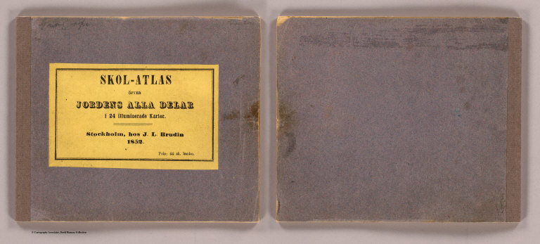
(Covers to) Skol-atlas ofver jordens alla delar i 24 illuminerade kartor. Efter Stielers Hand-Atlas. Stockholm, J.L. Brudin, 1852.
List No
2605A
Note
Title on label pasted on gray paper covers: Skol-atlas ofver jordens alla delar i 24 illuminerade kartor. Stockholm, hos J.L. Brudin, 1852. Pris: 44 sk. banko.
Author
[Brudin, J. L., Stieler, Adolf]
Full Title
(Title Page to) Skol-atlas ofver jordens alla delar i 24 illuminerade kartor. Efter Stielers Hand-Atlas. Stockholm, J.L. Brudin, 1852.
List No
2605B
Note
Includes table of contents.
Author
[Askergren, O. A., Brudin, J. L., Stieler, Adolf]
Full Title
(Preface to) Skol-atlas ofver jordens alla delar i 24 illuminerade kartor. Efter Stielers Hand-Atlas. Stockholm, J.L. Brudin, 1852.
List No
2605C
Note
By O.A. Askergren "Rector vid Storkyrkofors, Folk-Skola."
Full Title
Oestliche Halbkugel. (Efter Stielers Hand-Atlas. Stockholm, J.L. Brudin, 1852)
List No
2605.001
Note
Engraved map. Outline hand coloring. In German. Prime meridian: Ferro.
Full Title
Westliche Halbkugel. (Efter Stielers Hand-Atlas. Stockholm, J.L. Brudin, 1852)
List No
2605.002
Note
Engraved map. Outline hand coloring. In German. Prime meridian: Ferro.
Full Title
Europa. (Efter Stielers Hand-Atlas. Stockholm, J.L. Brudin, 1852)
List No
2605.003
Note
Engraved map. Outline hand coloring. In German. Prime meridian: Ferro.
Full Title
Asia. (Efter Stielers Hand-Atlas. Stockholm, J.L. Brudin, 1852)
List No
2605.004
Note
Engraved map. Outline hand coloring. Relief shown by hachures. In German. Prime meridian: Ferro.
Full Title
Africa. (Efter Stielers Hand-Atlas. Stockholm, J.L. Brudin, 1852)
List No
2605.005
Note
Engraved map. Outline hand coloring. Relief shown by hachures. In German. Prime meridian: Ferro.
Full Title
Nord-America und West-Indien. (Efter Stielers Hand-Atlas. Stockholm, J.L. Brudin, 1852)
List No
2605.006
Note
Engraved map. Outline hand coloring. Relief shown by hachures. In German. Prime meridian: Ferro.
Full Title
Sud-America. (Efter Stielers Hand-Atlas. Stockholm, J.L. Brudin, 1852)
List No
2605.007
Note
Engraved map. Outline hand coloring. Relief shown by hachures. In German. Prime meridian: Ferro.
Full Title
Australien. (Efter Stielers Hand-Atlas. Stockholm, J.L. Brudin, 1852)
List No
2605.008
Note
Engraved map. Outline hand coloring. In German. Prime meridian: Ferro.
Full Title
Spanien und Portugal. (Efter Stielers Hand-Atlas. Stockholm, J.L. Brudin, 1852)
List No
2605.009
Note
Engraved map. Outline hand coloring. Relief shown by hachures. In German. Prime meridian: Ferro.
Full Title
Sud-ostliches Deutschland, enthalt die Oesterreichischen Lande. (Efter Stielers Hand-Atlas. Stockholm, J.L. Brudin, 1852)
List No
2605.017
Note
Engraved map. Outline hand coloring. Relief shown by hachures. In German. Prime meridian: Ferro.
Full Title
Die Schweiz und das Furstenthum Liechtenstein. (Efter Stielers Hand-Atlas. Stockholm, J.L. Brudin, 1852)
List No
2605.018
Note
Engraved map. Outline hand coloring. Relief shown by hachures. In German. Prime meridian: Ferro.
Full Title
Preuss. Provinzen, Preussen u. Posen, Kgr. Polen und Freistaat Krakau. (Efter Stielers Hand-Atlas. Stockholm, J.L. Brudin, 1852)
List No
2605.019
Note
Engraved map. Outline hand coloring. Relief shown by hachures. In German. Prime meridian: Ferro.
Full Title
Galizien, Ungarn, Slavonien und Kroatien, Siebenburgen und Dalmatien, Moldau, Wallachey. (Efter Stielers Hand-Atlas. Stockholm, J.L. Brudin, 1852)
List No
2605.020
Note
Engraved map. Outline hand coloring. Relief shown by hachures. In German. Prime meridian: Ferro.
Full Title
Daenemark mit Schleswig, Holstein und Lauenburg, nebst Island und den Faer-Oer. (Efter Stielers Hand-Atlas. Stockholm, J.L. Brudin, 1852)
List No
2605.021
Note
Engraved map. Outline hand coloring. In German. Prime meridian: Ferro.
Full Title
Schweden, Norwegen und Finnland. (Efter Stielers Hand-Atlas. Stockholm, J.L. Brudin, 1852)
List No
2605.022
Note
Engraved map. Outline hand coloring. Relief shown by hachures. In German. Prime meridian: Ferro.
Full Title
Europaeisches Russland. (Efter Stielers Hand-Atlas. Stockholm, J.L. Brudin, 1852)
List No
2605.023
Note
Engraved map. Outline hand coloring. Relief shown by hachures. In German. Prime meridian: Ferro.
Full Title
Des Osmanischen Reichs, europaeischer Theil, Kgr. Griechenland und die Ionischen Inseln. (Efter Stielers Hand-Atlas. Stockholm, J.L. Brudin, 1852)
List No
2605.024
Note
Engraved map. Outline hand coloring. Relief shown by hachures. In German. Prime meridian: Ferro.
Author
[Fenner, Rest., Thomas, Joseph, publisher]
Full Title
(Covers to) Thomas's library atlas, embodying a complete set of maps, illustrative of modern & ancient geography ... London, Joseph Thomas, 1, Finch Lane, 1835. Sold by Simpkin & Marshall, Stationers Court.
List No
3362A
Note
Redish-brown quarter leather, dark green cloth. Spine title: Thomas's library atlas.
Author
[Fenner, Rest., Thomas, Joseph, publisher]
Full Title
(Title Page to) Thomas's library atlas, embodying a complete set of maps, illustrative of modern & ancient geography ... London, Joseph Thomas, 1, Finch Lane, 1835. Sold by Simpkin & Marshall, Stationers Court.
List No
3362B
Note
Reissue of Fenner's Pocket atlas 1830. See Tooley Dict. p 206 - Fenner, R. The U.S. map runs to the west coast, Alabama Territory indicates a pre 1820 original map -- was there an issue of this atlas before the 1830 issue? The t-p refers to the peace treaty of 1815. Roger Baskes has the 1830 and this 1835 ed. The mountain and rivers plates is exceptional. David Rumsey Collection copy lacks pt. 1, pl. 9 "England"; duplicate copy of pt. 2, pl. 9 "Persis, Parthia, Armenia, etc."
Author
[Fenner, Rest., Thomas, Joseph, publisher]
Full Title
(Contents to) Thomas's library atlas, embodying a complete set of maps, illustrative of modern & ancient geography ... London, Joseph Thomas, 1, Finch Lane, 1835. Sold by Simpkin & Marshall, Stationers Court.
List No
3362C
Note
Lists classical maps 1-26.
Author
[Fenner, Rest., Thomas, Joseph, publisher]
Full Title
(Contents to) Thomas's library atlas, embodying a complete set of maps, illustrative of modern & ancient geography ... London, Joseph Thomas, 1, Finch Lane, 1835. Sold by Simpkin & Marshall, Stationers Court.
List No
3362D
Note
Lists modern maps 1-53 plus "Comparative lengths of rivers & heights of mountains."
Author
Fenner, Rest.
Full Title
The World as known to Ptolemy. Fenner Sc., Paternoster Row. (London, Joseph Thomas, 1835)
List No
3362.001
Note
Engraved map. Outline hand coloring. Relief shown by hachures.
Author
Fenner, Rest.
Full Title
Asia Antiqua. Fenner Sc., Paternoster Row. (London, Joseph Thomas, 1835)
List No
3362.002
Note
Engraved map. Outline hand coloring. Relief shown by hachures. Prime meridians: Ferro and Greenwich.
Author
Fenner, Rest.
Full Title
Africa Antiqua. Fenner Sc., Paternoster Row. (London, Joseph Thomas, 1835)
List No
3362.003
Note
Engraved map. Outline hand coloring. Relief shown by hachures. Prime meridians: Ferro and Greenwich.
|