Author
Johnston, Alexander Keith, 1804-1871
Full Title
(Text Page to) The physical atlas of natural phenomena by Alexander Keith Johnston, F.R.S.E., F.R.G.S., F.G.S. ... A new and enlarged edition. William Blackwood and Sons, Edinburgh and London, MDCCCLVI. [The Author reserves the right of translation]
List No
0372C
Note
"Preface to the second edition ... A. Keith Johnston. Edinburgh, June 1856."
Author
Johnston, Alexander Keith, 1804-1871
Full Title
(Contents to) The physical atlas of natural phenomena by Alexander Keith Johnston, F.R.S.E., F.R.G.S., F.G.S. ... A new and enlarged edition. William Blackwood and Sons, Edinburgh and London, MDCCCLVI. [The Author reserves the right of translation]
List No
0372D
Note
List of plates, 1st sheet.
Author
Johnston, Alexander Keith, 1804-1871
Full Title
(Contents to) The physical atlas of natural phenomena by Alexander Keith Johnston, F.R.S.E., F.R.G.S., F.G.S. ... A new and enlarged edition. William Blackwood and Sons, Edinburgh and London, MDCCCLVI. [The Author reserves the right of translation]
List No
0372E
Note
List of plates, 2nd sheet.
Author
[Gunnison, J.W., Preuss, C., Stansbury, Howard]
Full Title
Map of the Great Salt Lake And Adjacent Country in the Territory Of Utah. Surveyed in 1849 and 1850, under the orders of Col. J.J. Abert ... by Capt. Howard Stansbury ... aided by Lieut. J.W. Gunnison ... and Albert Carrington. Drawn By Lieut. Gunnison And Charles Preuss. Ackerman Lith. 379 Broadway N.Y.
List No
0950.001
Note
One of the earliest, and most important government maps of the Great Salt Lake area. Wheat calls this map "a major production...for the Great Salt Lake itself the map was definitive...Scientific cartography for the Territory of Utah may be said to date from the appearance of this map." It is a stunning map, large in scope, and clearly shows the genius of Charles Preuss as a cartographer. Issued in a folder with the large Stansbury "Map of a Reconnoissance between Fort Leavenworth..." Bodies of water have light blue outline color.
Gunnison, J.W.; Preuss, C.; Stansbury, H... Map of a Reconnoissance between Fort Lea... 1852 0950.002 Related Author
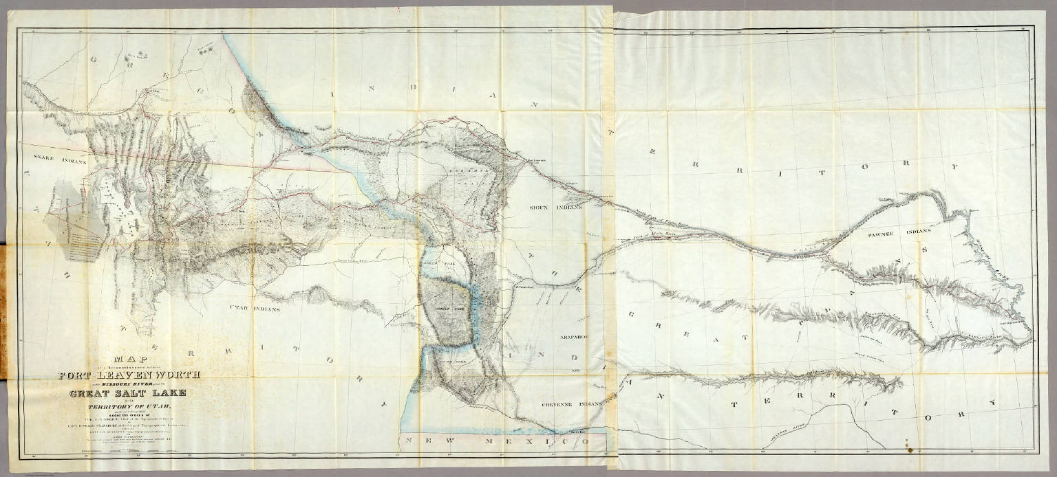
[Gunnison, J.W., Preuss, C., Stansbury, Howard]
Full Title
Map of a Reconnoissance between Fort Leavenworth on the Missouri River, and the Great Salt Lake in the Territory Of Utah, made in 1849 and 1850 under the orders of Col. J.J. Abert ... By Capt. Howard Stansbury ... aided by Lieut. J.W. Gunnison ... and Albert Carrington. The adjacent country laid down from the latest and most authentic data. Drawn by Lieut. Gunnison and Charles Preuss. Ackerman Lith. 379 Broadway N.Y.
List No
0950.002
Note
This is the Fremont/Preuss map of 1845, updated and enlarged, but only going west to the Great Salt Lake. Wheat: "the Stansbury expedition map (is) one of the most important of its decade." Wheat devotes seven pages to this map. It is a major production and is the culmination of the Fremont maps of 1843 and 1845, and the Abert map of 1846. Issued in a folder with the large Stansbury "Map of The Great Salt Lake and Adjacent Country.." With outline color.
Gunnison, J.W.; Preuss, C.; Stansbury, H... Cover: Exploration & Survey, Valley of t... 1852 0950A Related Author
[Gunnison, J.W., Preuss, C., Stansbury, Howard]
Full Title
(Covers to maps of the) Exploration and Survey of the Valley of the Great Salt Lake of Utah, including a Reconnoissance of a new Route through the Rocky Mountains. By Howard Stansbury ... Philadelphia: Lippincott, Grambo & Co. 1852.
List No
0950A
Gunnison, J.W.; Preuss, C.; Stansbury, H... Title Page: Exploration and survey of th... 1852 0950B Related Author
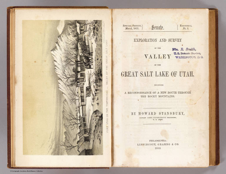
[Gunnison, J.W., Preuss, C., Stansbury, Howard]
Full Title
(Title Page to) Exploration and Survey of the Valley of the Great Salt Lake of Utah, including a Reconnoissance of a new Route through the Rocky Mountains. By Howard Stansbury ... (with view) Fort Utah on the Timpanogas - Valley of the Great Salt Lake. Philadelphia: Lippincott, Grambo & Co. 1852.
List No
0950B
Note
Title page with facing view by A. Fay.
Author
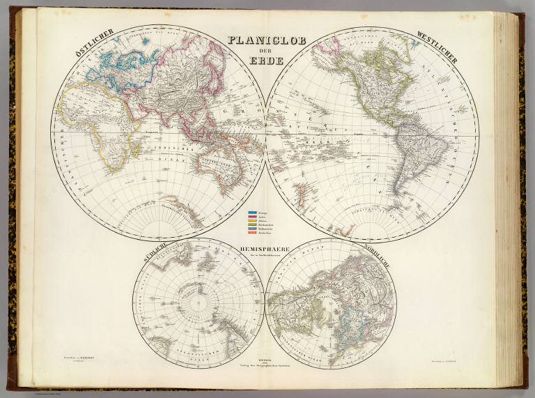
[Geographisches Institut (Weimar, Germany), Kiepert, Heinrich, 1818-1899]
Full Title
Planiglob der Erde. Ostlicher. Westlicher. Sudliche, Nordliche Hemisphaere bis zu den Wendekreisen. Gezeichnet von H. Kiepert u C. Ohmann. Gestochen von E. Kratz. Weimar, 1856, Verlag des Geographischen Instituts.
List No
2077.001
Note
Double hemisphere engraved map. Outline hand col. Relief shown by hachures. Southern and northern hemisphere shown on smaller ancillary hemispheric maps.
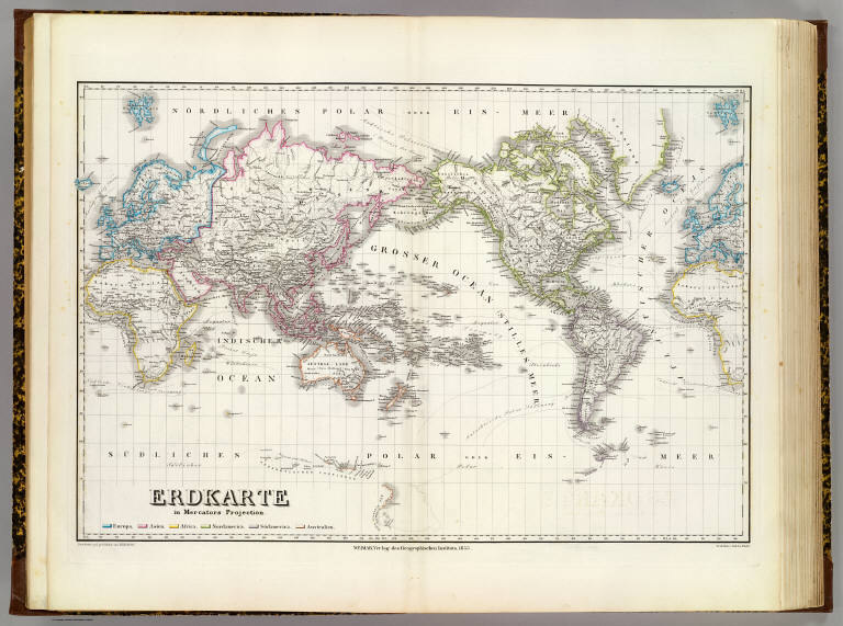
Author
[Geographisches Institut (Weimar, Germany), Kiepert, Heinrich, 1818-1899]
Full Title
Erdkarte in Mercators Projection. Bearbeitet und gezeichnet von H. Kiepert. Gestochen v. Carl Jos. Madel. Weimar, Verlag des Geographischen Instituts, 1853.
List No
2077.002
Note
Engraved map. Continents in outline hand col. Relief shown by hachures. Shows ocean currents, etc.
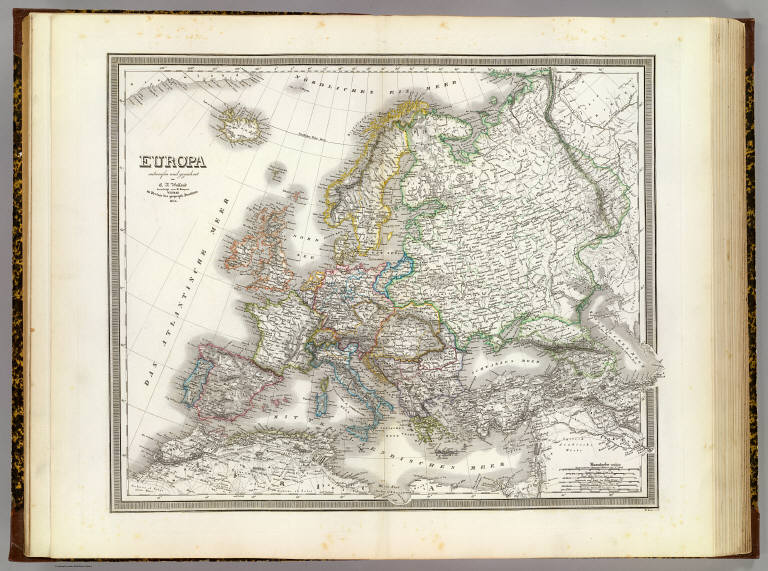
Author
[Geographisches Institut (Weimar, Germany), Kiepert, Heinrich, 1818-1899, Weiland, Carl Ferdinand, 1782 -1847]
Full Title
Europa, entworfen und gezeichnet von C.F. Weiland, berichtigt von H. Kiepert. Weimar, im Verlage des geograph. Instituts, 1856. W. Kratz sen., sc.
List No
2077.003
Note
Engraved map. Countries in outline hand col. Relief shown by hachures.
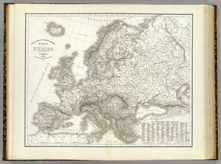
Author
[Geographisches Institut (Weimar, Germany), Weiland, Carl Ferdinand, 1782 -1847]
Full Title
Orographisch-hydrographische Karte von Europa, entworfen und gezeichnet von C.F. Weiland. C. Jungmann sc. Weimar, im Verlage des geographischen Instituts, 1856.
List No
2077.004
Note
Engraved map. Relief shown by hachures. Includes key to mountain peaks.
Author
[Geographisches Institut (Weimar, Germany), Weiland, Carl Ferdinand, 1782 -1847]
Full Title
Deutschland, entworfen und gezeichnet von C.F. Weiland. Weimar: Verlag des geographischen Instituts, 1855.
List No
2077.005
Note
Engraved map. Political entities in outline col. Relief shown by hachures.
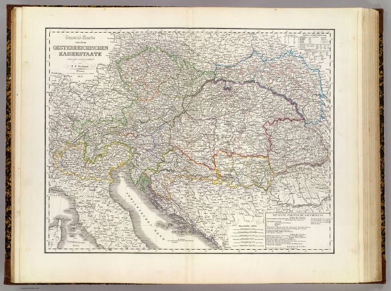
Author
[Geographisches Institut (Weimar, Germany), Weiland, Carl Ferdinand, 1782 -1847]
Full Title
General-Karte von dem oesterreichischen Kaiserstaate, entworfen und gezeichnet von C.F. Weiland. Weimar, im Verlage des geographischen Instituts, 1855.
List No
2077.006
Note
Engraved map. Outline hand col. Relief shown by hachures. Includes key.
Author
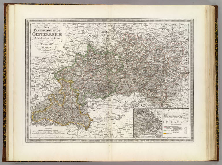
[Geographisches Institut (Weimar, Germany), Weiland, Carl Ferdinand, 1782 -1847]
Full Title
Das Erzherzogthum Oesterreich ob- und unter der Enns, entworfen und gezeichnet von C.F. Weiland. Weimar, im Verlage des Geographischen Instituts. Die Eintheilung berichtigt 1856.
List No
2077.007
Note
Engraved map. Outline hand col. Relief shown by hachures. Includes inset map of Vienna region.
Author
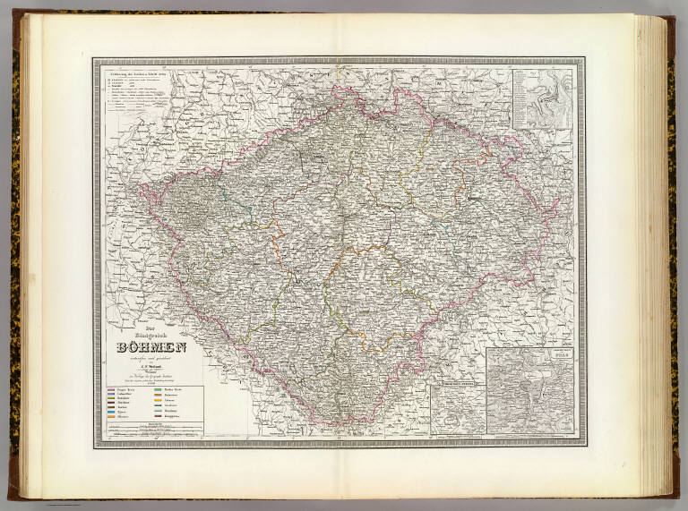
[Geographisches Institut (Weimar, Germany), Weiland, Carl Ferdinand, 1782 -1847]
Full Title
Das Konigreich Bohmen, entworfen und gezeichnet von C.F. Weiland. (with) Plan von Carlsbad. (with) Umgebungen von Prag. (with) Umgebungen v. Teplitz. Weimar, im Verlage des Geograph. Instituts. Nach der neuesten politischen Eintheilung berichtigt. 1856.
List No
2077.008
Note
Engraved map. Outline hand col. Relief shown by hachures. Shows Kreis boundaries.
Author
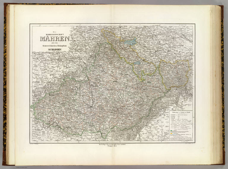
[Geographisches Institut (Weimar, Germany), Weiland, Carl Ferdinand, 1782 -1847]
Full Title
Die Markgrafschaft Mahren nebst dem Oesterreichischen Herzogthum Schlesien. Gezeichnet v. C.F. Weiland. Gest. v. C. Hensgen sen. Im Verlage des Geographischen Instituts, Weimar, 1856.
List No
2077.009
Note
Engraved map. Outline hand col. Relief shown by hachures. Prime meridians: Paris and Ferro.
Author
[Geographisches Institut (Weimar, Germany), Weiland, Carl Ferdinand, 1782 -1847]
Full Title
Die K. osterreichischen Kronlander Steiermark, Karnthen, Krain und das Kustenland, Gorz, Gradisca, Istrien und Triest, gezeichnet von C.F. Weiland. Nach den neuesten politischen Eintheilung berichtigt, 1856. Weimar, Verlag des Geographischen Instituts.
List No
2077.010
Note
Engraved map. Outline hand col. Relief shown by hachures.
Author
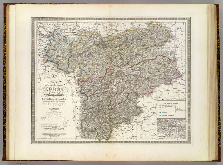
[Austro-Hungarian Monarchy. Militar-Geographisches Institut, Geographisches Institut (Weimar, Germany), Weiland, Carl Ferdinand, 1782 -1847]
Full Title
Die gefuerstete Grafschaft Tyrol nebst Vorarlberg und dem Furstenthum Liechtenstein, nach der vom Kaiserl. Oesterreichischen General Quartiermeisterstabe herausgegebenen Specialkarte entworfen und gezeichnet von C.F. Weiland. (with) Umbegungen von Innsbruck. Weimar, im Verlage des Geograph. Instituts. Nach den neuesten politischen Eintheilung berichtigt. 1856.
List No
2077.011
Note
Engraved map. Outline hand col. Relief shown by hachures. Inset map at 1:144,000 scale.
Author
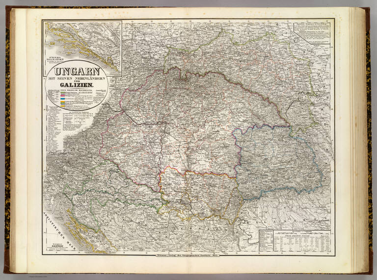
[Geographisches Institut (Weimar, Germany), Kiepert, Heinrich, 1818-1899]
Full Title
Ungarn mit seinen Nebenlandern und Galizien. (with) Sudliches Dalmatien im Anschluss an den untern Rand der Haupktarte. Gezeichnet von H. Kiepert, nach der Karte von Schedius u. Blaschnek in 9 Bl. Gestochen von F. Eulenstein. Weimar, Verlag des Geographischen Instituts, 1855.
List No
2077.012
Note
Engraved map. Outline hand col. Includes inset map. Relief shown by hachures.
Author
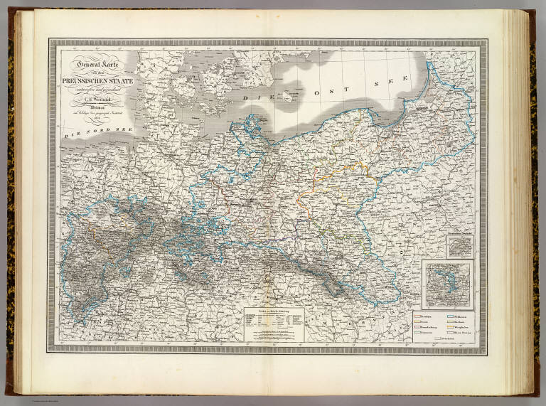
[Geographisches Institut (Weimar, Germany), Weiland, Carl Ferdinand, 1782 -1847]
Full Title
General Karte von dem Preussischen Staate, entworfen und gezeichnet von C.F. Weiland. Weimar, im Verlage des geograph. Instituts, 1856.
List No
2077.013
Note
Engraved map. Outline hand col. Relief shown by hachures. Includes inset maps of Hohenzollern Province (now in Baden-Wurttemberg) and "Furstenthum Neuchatel".
Author
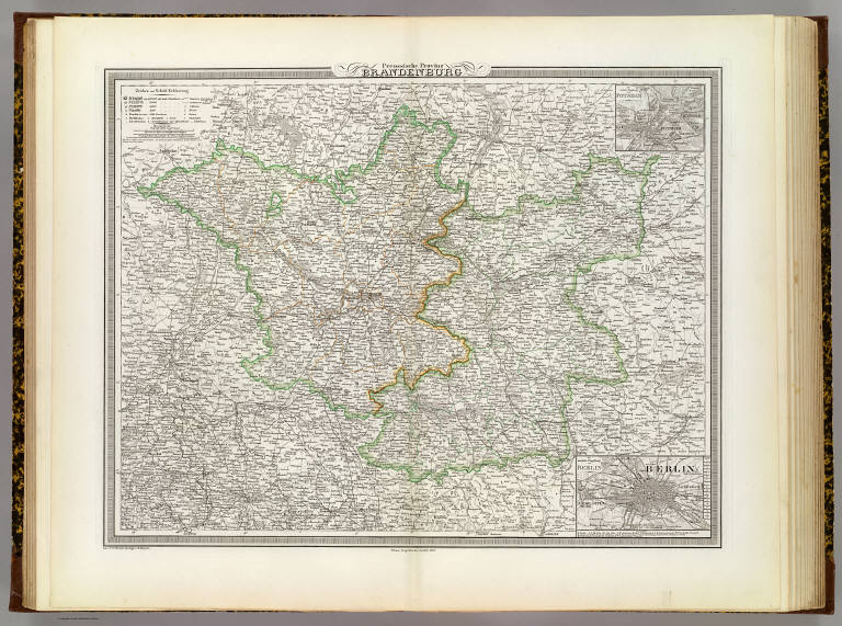
[Geographisches Institut (Weimar, Germany), Kiepert, Heinrich, 1818-1899, Weiland, Carl Ferdinand, 1782 -1847]
Full Title
Preussische Provinz Brandenburg. (with) Die nachste Umgebung von Potsdam. (with) Die nachste Umgebung von Berlin. Gez. v. C.F. Weiland, berichtigt von H. Kiepert. Weimar, Geographisches Institut, 1856.
List No
2077.014
Note
Engraved map. Outline hand col.
Author
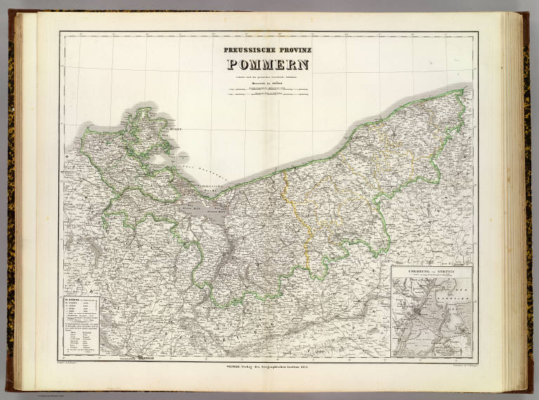
[Geographisches Institut (Weimar, Germany), Kiepert, Heinrich, 1818-1899]
Full Title
Preussische Provinz Pommern, reducirt nach den preussischen Generalstabe Aufnahmen. (with) Umgebung von Stettin. Redigirt von H. Kiepert. Gestochen von C. Hensgen. Weimar, Verlag des Geographischen Instituts, 1856.
List No
2077.015
Note
Engraved map. Outline hand col. Relief shown by hachures.
Author
[Geographisches Institut (Weimar, Germany), Weiland, Carl Ferdinand, 1782 -1847]
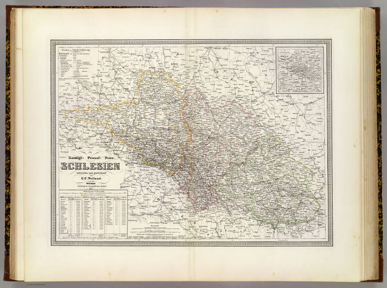
Full Title
Koenigl: Preuss: Prov: Schlesien, entworfen und gezeichnet von C.F. Weiland. (with) Die nachste Umgebung von Breslau. Weimar, im Verlage des Geographischen Instituts, 1856.
List No
2077.016
Note
Engraved map. Outline hand col. Relief shown by hachures. Includes area and population table. Prime meridian: Ferro.
Author
[Geographisches Institut (Weimar, Germany), Weiland, Carl Ferdinand, 1782 -1847]
Full Title
Die Konigl. Preussische Provinz Sachsen, nebst den Herzogl: Anhaltischen Laendern, entworfen von C.F. Weiland. Weimar, im Verlage der Geograph. Instituts, 1856.
List No
2077.017
Note
Engraved map with inset of Magdeburg area. Outline hand col. Relief shown by hachures. Includes area and population table.
Geographisches Institut (Weimar, Germany... Westphalen, Rhein-Privinz, Hessen. 1856 2077.018 Related Author
[Geographisches Institut (Weimar, Germany), Weiland, Carl Ferdinand, 1782 -1847]
Full Title
Die Konigl. Preussischen Provinzen Westphalen und Rhein-Provinz nebst dem Kurfurstenthum Hessen, Grossherzogthum Hessen, Herzogthum Nassau, Furstenthum Waldeck und dem Gebiete der freien Stadt Frankfurt, entworfen und gezeichnet von C.F. Weiland. Gest. v. C. Jungmann. Weimar, im Verlage der geographischen Instituts, 1856.
List No
2077.018
Note
Engraved map. Outline hand col. Relief shown by hachures. Includes area and population table.
Author
[Geographisches Institut (Weimar, Germany), Weiland, Carl Ferdinand, 1782 -1847]
Full Title
Karte von den Konigl: Preussischen Provinzen Preussen und Posen, nebst dem Kaiserlich Russischen Konigreiche Polen. (with) Umgebung von Warshau. (with) Umgebung von Konigsberg. (with) Umgebung von Danzig. Entworfen und gezeichnet von C.F. Weiland. Gestochen von J. Madel III. Weimar, im Verlage des geogr. Instituts, 1856.
List No
2077.019
Note
Engraved map. Outline hand col. Relief shown by hachures. Includes area and population table.
Author
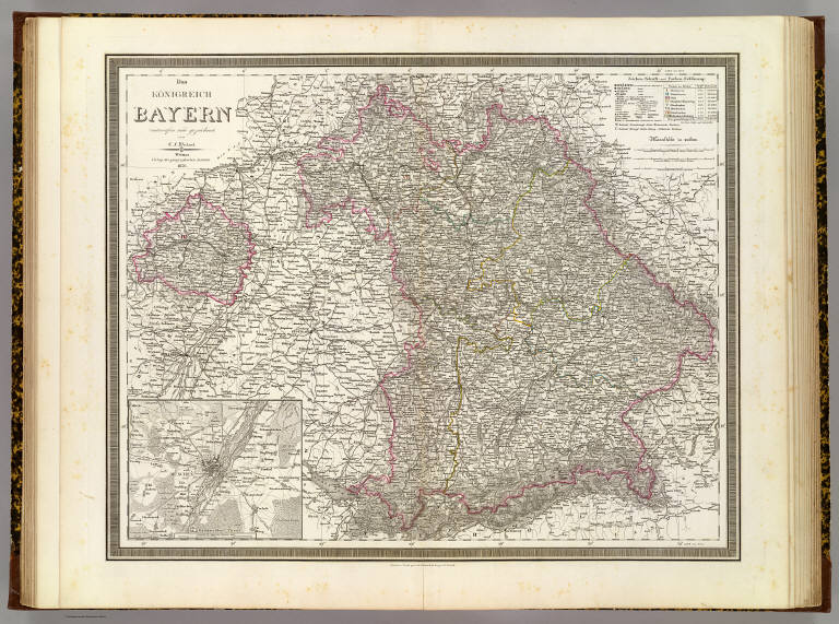
[Geographisches Institut (Weimar, Germany), Weiland, Carl Ferdinand, 1782 -1847]
Full Title
Das Konigreich Bayern, entworfen und gezeichnet von C.F. Weiland. Situation u. Schrift gest. von H. Eberhardt, die Berge v. R. Schmidt. Weimar, Verlag der geographischen Instituts, 1856.
List No
2077.020
Note
Engraved map with inset map of the Munich region. Outline hand col. Relief shown by hachures.
Author
[Geographisches Institut (Weimar, Germany), Kiepert, Heinrich, 1818-1899, Weiland, Carl Ferdinand, 1782 -1847]
Full Title
Das Konigreich Wurtemberg, das Grossherzogthum Baden. Nach C.F. Weilands Entwurf vollig umgearbeitet von H. Kiepert. Weimar, verlag des Geograph. Instituts, 1856.
List No
2077.021
Note
Engraved map. Outline hand col. Relief shown by hachures.
Author
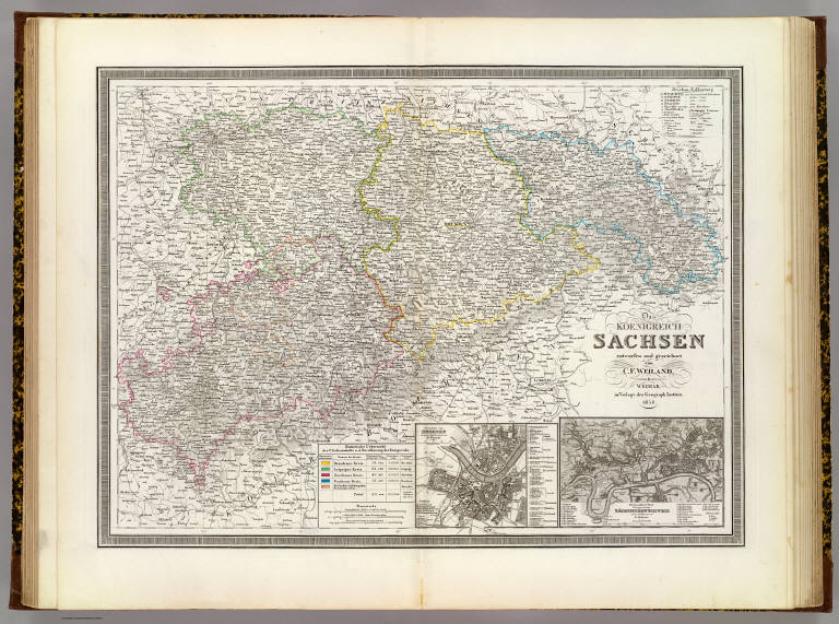
[Geographisches Institut (Weimar, Germany), Weiland, Carl Ferdinand, 1782 -1847]
Full Title
Das Koenigreich Sachsen, entworfen und gezeichnet von C.F. Weiland. (with) Grundriss von Dresden n.d. neust. Aufnahmen gez. von A. Roetsch. (with) Der besuchteste Theil dersogenannten Sachsischen Schweiz nach v. Odeleben gez. von F. Hockner. Gest. v. C. Poppey. Weimar, im Verlage des Geograph. Instituts, 1856.
List No
2077.022
Note
Engraved map with 2 inset maps. Outline hand col. Relief shown by hachures. Includes area and population table.
Geographisches Institut (Weimar, Germany... Hannover, Braunschweig, Oldenburg. 1856 2077.023 Related Author
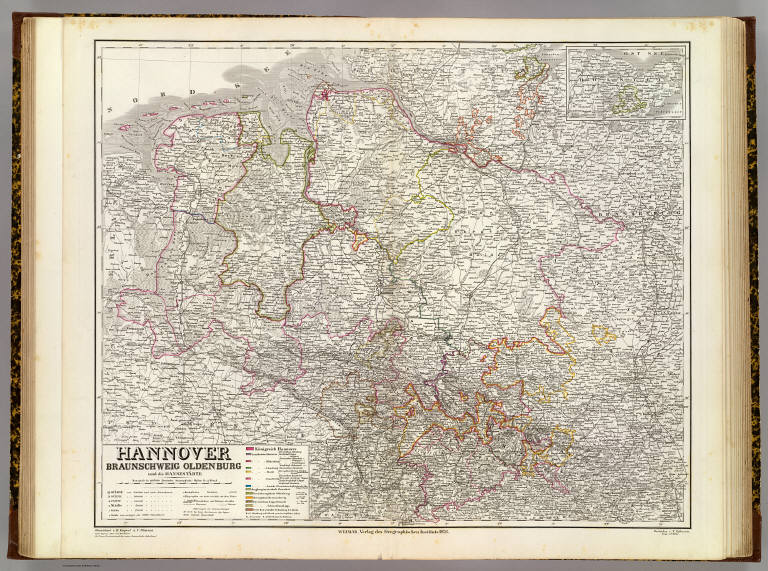
[Geographisches Institut (Weimar, Germany), Kiepert, Heinrich, 1818-1899, Ohmann, C. L.]
Full Title
Hannover, Braunschweig, Oldenburg und die Hansestadte. Gezeichnet v. H. Kiepert u. C. Ohmann nach Papens Atlas von Hannover. Gestochen v. F. Eulenstein. Berge v. W. Weiler. Weimar, Verlag des Geographischen Instituts, 1856.
List No
2077.023
Note
Engraved map. Outline hand col. Relief shown by hachures. Includes inset map.
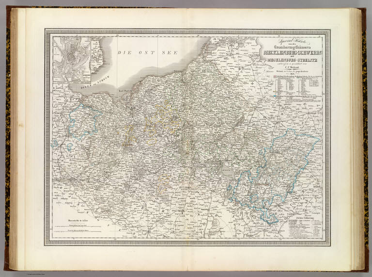
Geographisches Institut (Weimar, Germany... Mecklenburg-Schwerin, Mecklenburg-Streli... 1856 2077.024 Related Author
[Geographisches Institut (Weimar, Germany), Weiland, Carl Ferdinand, 1782 -1847]
Full Title
Special Karte von den Grossherzogthumern Mecklenburg-Schwerin und Mecklenburg-Strelitz, entworfen u. gezeichnet von C.F. Weiland. (with) Schwerin nebst Umgebungen. Weimar, im Verlage des geogr: Instituts, 1856. Gestochen von Carl Jungmann.
List No
2077.024
Note
Engraved map. Outline hand col.
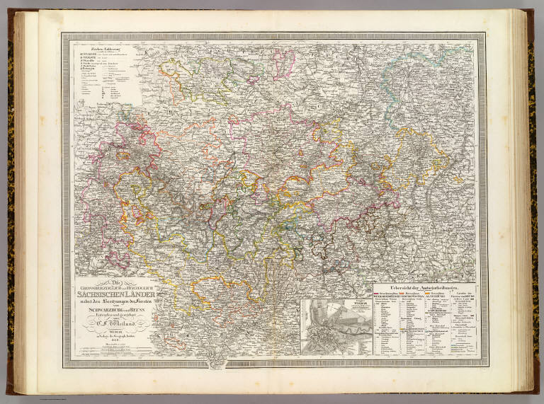
Author
[Geographisches Institut (Weimar, Germany), Weiland, Carl Ferdinand, 1782 -1847]
Full Title
Die Grossherzoglich und Herzoglich Sachsischen Lander nebst den Besitzungen der Fursten von Schwarzburg und Reuss. (with) Grundriss von Weimar ... von C. Hoeckner. Entworfen und gezeichnet von C.F. Weiland. C. Poppey sc. Weimar, im Verlage des Geograph. Instituts, 1856.
List No
2077.025
Note
Engraved map. Outline hand col. Relief shown by hachures.
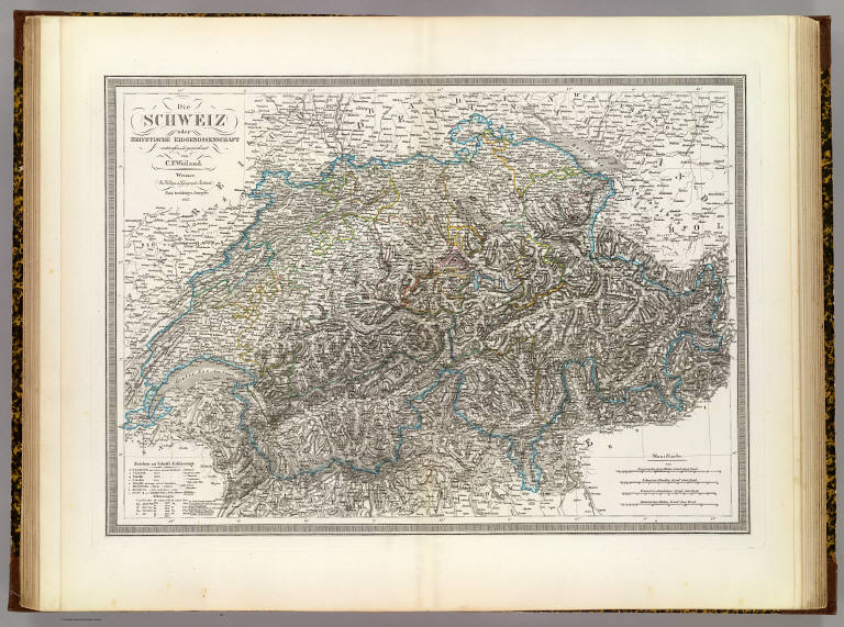
Author
[Geographisches Institut (Weimar, Germany), Weiland, Carl Ferdinand, 1782 -1847]
Full Title
Die Schweiz oder Helvetische Eidgenossenschaft, entworfen und gezeichnet von C.F. Weiland. Weimar, im Verlage des Geograph: Instituts. Neue berichtige Ausgabe, 1856.
List No
2077.026
Note
Engraved map. Outline hand col. Relief shown by hachures.
Author
[Geographisches Institut (Weimar, Germany), Kiepert, Heinrich, 1818-1899]
Full Title
Italien. Bearbeitet u. gezeichnet v. H. Kiepert. Gestochen v. C. Jungmann. Weimar, Verlag des Geographischen Instituts, 1853.
List No
2077.027
Note
Engraved map. Outline hand col. Relief shown by hachures. Prime meridians: Paris and Ferro.
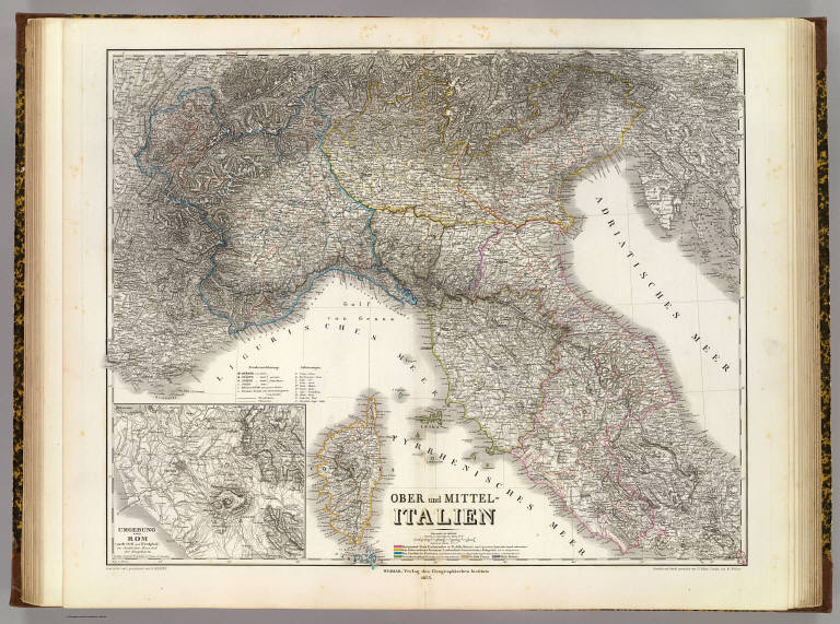
Author
[Geographisches Institut (Weimar, Germany), Kiepert, Heinrich, 1818-1899]
Full Title
Ober und Mittel-Italien. (with) Umgebung von Rom, nach Gell und Westphal, in dreisachen Maasstabe der Hauptarke. Bearbeitet und gezeichnet von H. Kiepert. Situation und Schrift gestochen von C.J. Madel, terrain von W. Weiler. Weimar, Verlag des Geographischen Instituts, 1855.
List No
2077.028
Note
Engraved map. Outline hand col. Relief shown by hachures. Includes Corsica. Prime meridians: Paris and Ferro.
Author
[Geographisches Institut (Weimar, Germany), Kiepert, Heinrich, 1818-1899]
Full Title
Unter Italien oder das Konigreich beider Sicilien. (with) Campagna Felice oder Umgebungen von Neapel. (with) Die Maltesischen Inseln. Bearbeitet und gezeichnet von H. Kiepert. Gest. von G. Haubold. Weimar, Verlag des Geographischen Instituts, 1856.
List No
2077.029
Note
Engraved map. Outline hand col. Relief shown by hachures and spot heights. Prime meridians: Paris and Ferro.
Author
[Geographisches Institut (Weimar, Germany), Weiland, Carl Ferdinand, 1782 -1847]
Full Title
Frankreich, entworfen und gezeichnet von C.F. Weiland. (with) Paris mit den Fortificationen. (with) Insel Corsica. Weimar, im Verlage des geographischen Instituts, 1855.
List No
2077.030
Note
Engraved map. Outline hand col. Relief shown by hachures. Prime meridians: Paris and Ferro.
Author
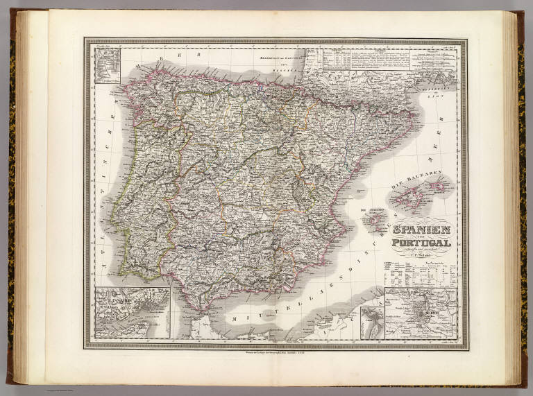
[Geographisches Institut (Weimar, Germany), Weiland, Carl Ferdinand, 1782 -1847]
Full Title
Spanien und Portugal, entworfen und gezeichnet von C.F. Weiland. (with Lissabon). (with Madrid). (with Cadiz). (with Gibraltar). Weimar, im Verlage des Geographischen Instituts, 1856.
List No
2077.031
Note
Engraved map. Outline hand col. Relief shown by hachures. Prime meridians: Paris and Ferro.
Author
[Geographisches Institut (Weimar, Germany), Kiepert, Heinrich, 1818-1899]
Full Title
Die Britischen Inseln, oder die Vereinigten Konigreich. (with) Die wichtigsten Fabrik-Districte im nordwestlichen England ... (with) Die wichtigsten Kohlen-Districte in Nordengland. (with Die Shetland Inseln). (with) Die Normannischen Inseln. Gezeichnet v. H. Kiepert. Gestochen v. E. Kratz.
List No
2077.032
Note
Engraved map. Outline hand col. Relief shown by hachures and spot heights. Shows settlements, railroads, canals, etc. Prime meridians: Ferro, Greenwich and Paris.
Author
[Geographisches Institut (Weimar, Germany), Graf, Carl, 1822-ca. 1897, Kiepert, Heinrich, 1818-1899]
Full Title
England. (with) London mit seinen nachsten Umgebungen. Gez. v. C. Graf, revidirt v. H. Kiepert. Weimar, Verlag des Geograph. Instituts, 1856.
List No
2077.033
Note
Engraved map. Outline hand col. Relief shown by hachures and spot heights. Prime meridians Ferro and Paris.
Author
[Geographisches Institut (Weimar, Germany), Weiland, Carl Ferdinand, 1782 -1847]
Full Title
Scotland, entworfen und gezeichnet von C.F. Weiland. Weimar, im Verlage des Geograph: Instituts, 1853.
List No
2077.034
Note
Engraved map. Outline hand col. Includes inset map of the Shetland Islands (continuation of map). Relief shown by hachures.
Author
[Geographisches Institut (Weimar, Germany), Weiland, Carl Ferdinand, 1782 -1847]
Full Title
Ireland, entworfen und gezeichnet von C.F. Weiland. Weimar, im Verlage des Geograph. Instituts. Berichtigt 1853.
List No
2077.035
Note
Engraved map. Outline hand col. Relief shown by hachures.
Author
[Geographisches Institut (Weimar, Germany), Kiepert, Heinrich, 1818-1899]
Full Title
Die Niederlande und Belgien. Gezeichnet v. H. Kiepert. Gestochen v. F. Eulenstein. Weimar, Verlag des Geograph. Instituts, 1856.
List No
2077.036
Note
Engraved map. Outline hand col. Covers also Luxembourg. Prime meridians: Ferro and Paris.
Author
[Geographisches Institut (Weimar, Germany), Weiland, Carl Ferdinand, 1782 -1847]
Full Title
Daenemark mit seinen Nebenlaendern in Europa, entworfen und gezeichnet von C.F. Weiland. (with) Island nach der, im Seekarten Archive zu Kopenhagen ... (with) Die Far-Oer Inseln. (with Kopenhagen). Weimar, im Verlage des geograph: Instituts, 1856.
List No
2077.037
Note
Engraved map. Outline hand col. Iceland map at (ca. 1:3,400,000) scale. Covers also present-day Schleswig-Holstein. Relief shown by hachures. Prime meridian: Ferro.
Author
[Geographisches Institut (Weimar, Germany), Kiepert, Heinrich, 1818-1899, Ohmann, C. L., Weiland, Carl Ferdinand, 1782 -1847]
Full Title
Die Herzogthumer Schleswig, Holstein und Lauenburg, entworfen u. gezeichnet von C.F. Weiland, unter Redaction v. H. Kiepert, berichtigt v. C. Ohmann. Weimar, im Verlage des geographischen Instituts, 1856.
List No
2077.038
Note
Engraved map. Hand col. Prime meridian: Ferro.
Author
[Geographisches Institut (Weimar, Germany), Weiland, Carl Ferdinand, 1782 -1847]
Full Title
Schweden und Norwegen, entworfen und gezeichnet von C.F. Weiland. Weimar, im Verlage des Geograph. Instituts, 1856. Schrift und Situation gestochen von Madel III, die Berge von Madel I.
List No
2077.039
Note
Engraved map. Outline hand col. Relief shown by hachures. Includes inset map of the Stockholm region. Includes statistical table. Prime meridian: Ferro.
Author
[Geographisches Institut (Weimar, Germany), Kiepert, Heinrich, 1818-1899, Weiland, Carl Ferdinand, 1782 -1847]
Full Title
Das Europaeische Russland, entworfen und gezeichnet von C.F. Weiland. Berichtigt von H. Kiepert. Weimar, im verlage des Geogr. Instituts, 1856.
List No
2077.040
Note
Engraved map. Outline hand col. Relief shown by hachures. Includes small inset map of St. Petersburg region.
Author
[Geographisches Institut (Weimar, Germany), Kiepert, Heinrich, 1818-1899, Weiland, Carl Ferdinand, 1782 -1847]
Full Title
Das Osmanische Europa oder die Europaeische Turkey nebst dem Konigreiche Griechenland und den Ionischen Inseln, entworfen und gezeichnet von C.F. Weiland. (with) Die Dardanellen Strasse nach original Aufnahmen von H. Kiepert. (with Constantinopel und Umgebung). Berichtigt 1849, nach Viquesnel, Leake, Boue, Grisebach und Karaczay, von H. Kiepert. Weimar, Geographisches Institut, 1855.
List No
2077.041
Note
Engraved map. Outline hand col. Relief shown by hachures. Dardanelles map at 1:800,000 scale. Prime meridian: Ferro.
Author
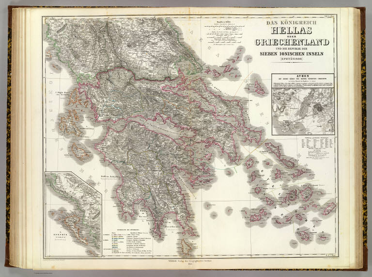
[Geographisches Institut (Weimar, Germany), Kiepert, Heinrich, 1818-1899]
Full Title
Das Konigreich Hellas oder Griechenland und die Republik der Sieben Ionischen Inseln, Ephtanisos. (with) Athen mit seinen Hafen und seiner nachsten Umgebung. (with) I(nsel) Korphus, Corfu, Kerkyra. Bearbeitet und gezeichnet von H. Kiepert. Gestochen von H. Herzberg. Weimar, Verlag des Geographischen Instituts, 1853.
List No
2077.042
Note
Engraved map. Outline hand col. Relief shown by hachures and spot heights. Athens map at 1:100,000 scale. Prime meridian: Ferro.
Author
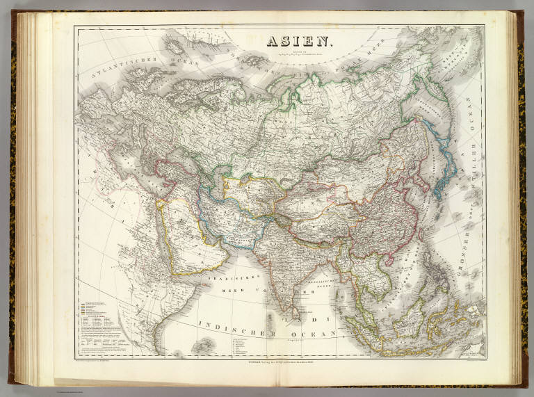
[Geographisches Institut (Weimar, Germany), Kiepert, Heinrich, 1818-1899]
Full Title
Asien. Bearbeitet und gezeichnet von H. Kiepert. Gestochen von C. Jungmann. Weimar, Verlag des Geographischen Instituts, 1856.
List No
2077.043
Note
Engraved map. Outline hand col. Relief shown by hachures. Relief shown by hachures. Prime meridian: Ferro.
|