|
REFINE
Media Group: zUrban ACTUAL
1-14 of 14
Author
Reid, John
Full Title
Plan of the City of Washington in the Territory of Columbia ceded by the States of Virginia And Maryland to the United States of America and by them established as the Seat of their Government, after the Year 1800. Rollinson sculp. N. York. Published by J. Reid L. Wayland and C. Smith 1795.
List No
5160.000
Note
State I of this map (State II lists only J. Reid as publisher). This map is taken from the first official plan of Washington published by Andrew Ellicott in 1792 (see Wheat & Brun 531). The Reid map is not an exact copy, with the title moved from the upper right to the lower left, several notes not included, and other elements moved. An exact copy of Reid's map appears in the London edition of Winterbotham's "View of the United States of America" (see our #3885). Howes gives precedence to the London edition, so it is not clear if Reid or Russell copied the Ellicott first. The Reid American Atlas index does not call for the Washington map, leading to the assumption that it was added to some copies afterwards, and speculation that it may have been sold as a separate. Scarce.
Author
Varle, Charles P.
Full Title
To The Citizens Of Philadelphia This New Plan Of The City And Its Environs Is respectfully dedicated By the Editor. 1802. P.C. Varle Geographer & Enginr. Del.
List No
5006.000
Note
A beautiful, early map of Philadelphia in full period color. The scale is given at 75 Perches to 1 inch. The city is shown from the Delaware River to the Schuylkil River with the environs on the north and south. 24 lettered references and 28 numbered references to important places and buildings are below the title and 24 wards are keyed in Roman numbers above the title. Many of the country houses and farms around the city are named, including Penn, Dr. Wistar, and other notable early residents. Three inset views show City Hall, the State House, Court House, Library, and Bank of the United States. The tile is surrounded by a decorative cartouche. The quality of the engraving is superb. Ristow mentions an undated edition that was possibly issued in the year Varle made the surveys, 1796, but more likely in 1802. Wheat and Brun list a c.1794 State I that has one less numbered building reference, no Roman numbered ward references, and "R. Scott Sculp. Philadelphia." This was Varle's first map published in the United States. Until 1807, Varle was known as Peter C. Varle; after 1807 he is known as Charles P. Varle.
Author
Britton & Rey
Full Title
Map of San Francisco, Compiled from latest Surveys & containing all late extensions & Division of Wards. Published By Britton & Rey, San Francisco Cal.
List No
4333.000
Note
Letter sheet map showing the "Lately planket (sic) Streets" and the original shoreline. Streeter estimates the date by comparison with the Butler and Zakreski maps, which are earlier and later, respectively. With a vignette of an untitled building in the lower right corner. This copy was owned by the noted San Francisco collector Dr. Alexander Thomas Leonard, with his signature and notes on the verso of the board the map is mounted on. According to Sally Woodbridge the firm of of Page, Bacon & Co., which owned the building in the lower right corner was at the top of the banking heap in 1852; it was est. in 1849 as a branch of a St. Louis bank. In the financial panic of 1855 it suffered a disastrous run and was ruined along with many other banks.
Author
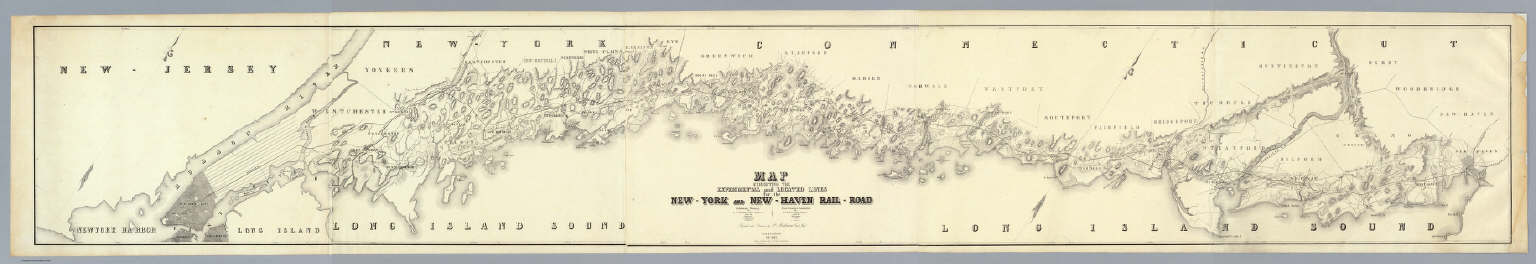
Anderson, P.
Full Title
Map Exhibiting The Experimental and Located Lines for the New-York and New-Haven Rail-Road ... Projected and Drawn by P. Anderson Civil Engr. Scale 1 to 40,000. Febr. 1845. Snyder & Black Lithogrs. 87 Fulton St. New-York.
List No
4218.000
Note
Greatly detailed strip map over ten feet long showing the surveyed routes of the New York and New Haven Railroad. The line was opened in 1849. The map is unique for a railroad map in its huge size, large scale, elegance of drawing, and variety of information shown (houses, trails, rivers, turnpikes, lighthouses, harbors, hills, swamps, etc.).
Author
Colton, G.W.
Full Title
Map Of Boston And Adjacent Cities. Published by J.H. Colton & Co. 172 William St. New York. Entered ... 1855 by J.H. Colton & Co. ... New York. No. 13.
List No
0149.021
Note
In full color. Areas in the Boston Harbor and the Mill Dam are sketched in with roads and open space.
Author
Jefferys, Thomas
Full Title
A Map of the most Inhabited part of New England, containing the Provinces of Massachusetts Bay and New Hampshire, with the Colonies of Conecticut And Rhode Island, Divided into Counties and Townships: The Whole composed from Actual Surveys and its Situation adjusted by Astronomical Observations. (with) A Plan of the Town of Boston. November 29th 1774. Published according to Act by Thos. Jefferys Geographer to His Royal highness the Prince of Wales near Charing Cross. (Northern section)
List No
0346.017
Note
Northern part of map in two sheets. In outline color except for section to the west of the Connecticut River, which is in yellow.
Author
[Jones, T.W., Moore, S.S.]
Full Title
Philadelphia and the commencement of the road to New York. 1. Shallus fc.
List No
2646.001
Note
Map without color.
Author
[Bouchette, Joseph, Faden, William, 1750?-1836]
Full Title
(Composite of eastern sheets) To His Royal Highness George Augustus Frederick ... This Topographical map of the Province of Lower Canada, shewing its division into Districts, Counties, Seigniories, & Townships ... Is ... Most gratefully dedicated by ... Joseph Bouchette, His Majesty's Surveyor General of the Province & Lieutt. Colonel C.M. ... Published by W. Faden, Charing Cross, Augst. 12th. 1815. Engraved by J. Walker & Sons, 47 Bernard Street, Russell Square, London. J. Walker sculp. (with) Town of Three Rivers. (with) City of Quebec. (with) Town of Montreal ...
List No
4431.013
Note
Four easternmost sheets of 10-sheet engraved map. Includes views, and ornamental cartouche. Relief shown by hachures; depths by soundings. Shows buildings in cities.
Author
[California. Office of State Engineer, Hall, Wm. Ham. (William Hammond)]
Full Title
Los Angeles & San Bernardino topography. Wm. H. Hall, State Engineer, Sacramento. (circa 1880)
List No
3451.000
Note
Beautiful hand drawn map of the Los Angles-San Bernardino Basin. Pen-and-ink and pencil. Relief shown by hachures. It appears to be a base map on a scale of two miles to an inch, probably preliminary (several of Hall's notations on the edges indicate corrections needed to the topography) and earlier than the 1888 Report titled "Irrigation in California" that had 15 maps that may have been derived from this map. It may also have served as the base for "Drainage area map to accompany report on irrigation and water supply in California" by Wm. Ham. Hall, State Engineer. (188-?). Hall was a famous engineer who was the first state engineer and was responsible for many of the early state water projects (see California Water Atlas). This map does not have any names drawn in except for a few towns, rivers, or railroads lightly penciled in. All the land divisions and city plats are indicated, with mountains, rivers, railroads, roads, arroyos and shorelines shown. Hall also published four maps of the San Joaquin Valley in 1886 (see WH's copy) separately (see Calfornia Water Atlas p.26). "VI." Title and cartographer from verso. "14" on verso.
Author
[Glover, E. S., Illustrated Directory Company]
Full Title
Kearny Street - west side - from Sutter to Bush St. E.S. Glover, photo-eng. (The illustrated directory ... Vol 1. San Francisco. Part 1. Kearny Street. Published by the Illustrated Directory Company ... Copyright 1894, by Eli S. Glover)
List No
4642.005
Note
Drawn illustrations of building street fronts and business establishments. Includes key.
Author
Rand McNally and Company
Full Title
Rand, McNally & Co.'s indexed atlas of the world map of Boston. Rand, McNally & Co's New business atlas map of Boston. Copyright, 1891, by Rand, McNally & Co., Chicago. (1897)
List No
3565.071
Note
Col. map. Shows major buildings, parks, cemeteries, etc. Insets: Environs of Boston. Scale (ca. 1:140,000) -- Business portion of Boston. Scale (ca. 1:5,600). Title in margin: Rand, McNally & Company's indexed atlas of the world.
Author
Rand McNally and Company
Full Title
Rand, McNally & Co.'s indexed atlas of the world map of Washington, D.C. Rand, McNally & Co's New business atlas map of Washington, D.C. Copyright, 1893, by Rand, McNally & Co. (Chicago, 1897)
List No
3565.084
Note
Col. map. Shows major buildings, parks, cemeteries, etc. Title in margin: Rand, McNally & Company's indexed atlas of the world.
Author
[Andreas, A. T. (Alfred Theodore), 1839-1900, Ellsbury, Geo. H.]
Full Title
St. Paul, Minn. Geo. H. Ellsbury, del. Hoffman (lithographer). Chas. Shober & Co., Proprietors of Chicago Lith. Co. Entered, according to act of Congress, year 1874, by G.H. Ellsbury and Vernon Green ... (Published by A.T. Andreas, Lakeside Building, Chicago)
List No
3034.012
Note
Col. lithograph. Panoramic view.
Author
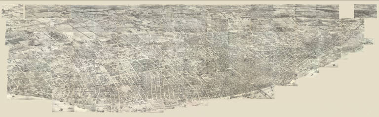
[Compton, Richard J., Dry, Camille N.]
Full Title
(Pictorial St. Louis) Composite (By C.N. Dry, 1876)
List No
4209.058
Note
Composite of 110 lithographed views.
1-14 of 14
|