Author
Lucas, Fielding Jr.
Full Title
Comparative Height of the Principal Mountains and other Elevations in the World. J. Cone Sc. Published by F. Lucas Jr. Baltimore.
List No
4584.001
Note
Altitude shown for Western Hemisphere and Eastern Hemisphere in feet. Full color.
Author
Ensigns & Thayer
Full Title
Map of the Gold Regions of California, Showing the Routes via Chagres and Panama, Cape Horn, &c.
List No
4683.000
Note
This is the thin paper copy with smaller ornamental border and no publisher credit. Wheat believes it was folded into some copies of Farnham's "Life, Adventures, and Travels in California;" our copies of that book have the Haven map pasted in one (see our #3963) and this map pasted in the other (see our #5001). This copy shows signs of being folded. It was probably sold with the book and separately. The text is the same as the broadside issue but the title is in different type. Scarce.
Author
[Darton, William, Gardner, W.R.]
Full Title
(Covers to) New and Improved View of the Comparative Heights of the Principal Mountains and Lengths of the Principal Rivers In The World, The whole Judiciously arranged from the various Authorities Extant. By W.R. Gardner. London: William Darton, 58 Holborn Hill, 10 Mo. 23rd, 1823. W.R. Gardner Sculpt. 367 Strand.
List No
4608A
Author
[Darton, William, Gardner, W.R.]
Full Title
New and Improved View of the Comparative Heights of the Principal Mountains and Lengths of the Principal Rivers In The World, The whole Judiciously arranged from the various Authorities Extant. By W.R. Gardner. London: William Darton, 58 Holborn Hill, 10 Mo. 23rd, 1823. W.R. Gardner Sculpt. 367 Strand.
List No
4608.001
Note
This may be the earliest chart to depict the heights of mountains and the lengths of rivers together in one illustration, with the rivers hanging down over the mountains. Wolter says that Bulla's Tableau Comparatif of 1826 is the earliest of the combined mountain and river type, but he had not seen this chart by Gardner done three years earlier and does not list it. This chart is beautifully done and, while not large in size, it is impressive in its scope. Full color. Map is mounted on linen, dissected into 8 sections with an end sheet label reading "The Most Approved Modern Maps, Plans, And Charts, Of every Description, From The Best Authorities, Constantly on Sale at William Darton's Map, Print, and Chart Warehouse, 58, Holborn Hill, London..." Map folds into a dark green marbled cardboard case with a turquoise paper label printed with the map title (as above); there is a "William Darton's, Map seller" bookplate label on the back of the case.
Author
Finley, Anthony
Full Title
Table of the Comparative Heights of the Principal Mountains &c. in the World ... Published by A. Finley Philada. Young & Delleker Sc.
List No
0285.062
Note
Full color.
Author
Finley, Anthony
Full Title
The Places Recorded in the Five Books of Moses. Thackara Sculpt. Published by A. Finley Philada. 1827. (with) Two inset maps: Canaan Aram & c. and The Eastern Countries as mentioned by Moses.
List No
0285.069
Note
Each map in full color with the main map detailing the route of Moses in the desert after the flight from Egypt.
Author
Finley, Anthony
Full Title
The Land Of Moriah Or Jerusalem and the Adjacent Country. H.S. Tanner. Published by A. Finley Philada. 1827.
List No
0285.070
Note
Full color map of Jerusalem showing the area including Bethlehem, Gibeon, and Mount Calvary. A key explains the places of note and Biblical passages are included next to significant landmarks.
Author
Tanner, Henry S.
Full Title
Heights Of The Principal Mountains In The World. F. Humphrys sculpt. Published by H.S. Tanner, Philadelphia. Entered ... 1836, by H.S. Tanner ... Pennsylvania. (above neat line) Tanner's Universal Atlas.
List No
0977.069
Note
In full color with length of rivers shown opposite the moutains. List of heights by country given with corresponding number on mountain ranges.
Author
[Carey, H. C., Lea, I.]
Full Title
Map And Description Of The Principal Mountains, &c. Throughout The World. Western Hemisphere. Eastern Hemisphere. Comparative Heights Of The Principal Mountains And Other Elevations In The World. No. 52. Arranged by F. Lucas Jr. Engraved by Young & Delleker.
List No
0122.047
Note
Without color and surrounded by text.
Author
[Carey, H. C., Lea, I.]
Full Title
Map Of The Principal Rivers Throughout The World. Comparative Lengths of the Principal Rivers throughout the World. No. 53. Drawn by F. Lucas Jr. J. Yeager Sculp.
List No
0122.048
Note
In full color and surrounded by text.
Author
[Martin, R.M., Tallis, J. & F.]
Full Title
A Comparative View Of The Principal Waterfalls, Islands, Lakes, Rivers and Mountains, In The Eastern Hemisphere. Designed & Engraved by John Rapkin. John Tallis & Company, London & New York.
List No
0466.001
Note
Without color in 4 sections with a decorative border.
Author
[Martin, R.M., Tallis, J. & F.]
Full Title
A Comparative View Of The Principal Waterfalls, Islands, Lakes, Rivers and Mountains, In The Western Hemisphere. Designed & Engraved by John Rapkin. John Tallis & Company, London & New York.
List No
0466.002
Note
Without color in 4 sections with a decorative border.
Author
Maclure, William
Full Title
(Title Page to) Observations on the Geology of the United States, explanatory of a Geological Map. By William Maclure. Read January 20th, 1809. (In) Transactions of the American Philosophical Society, Held at Philadelphia, for promoting Useful Knowledge. Volume VI. Published by C. and A. Conrad and Co. Philadelphia. ... Jane Aitken, Printer. 1809.
List No
2749A
Note
1st edition of the first geological map of U.S. A portion of a map of the U.S. by Samuel Lewis is used to make this map. The full sheet of paper was put on a larger plate and pulled, leaving the upper and right side without borders, as issued. Uncut and untrimmed, the map appears here with Maclure's original essay on the geology of the U.S. In 1817 Maclure published an expanded versus of his essay, using the small Melish Map of the U.S. as a base. Maclure was dissatisfied with the Lewis map because of its rendering of the mountains, and an errata slip is attached to the back of p 423 explaining this (and stating that originally it was intended to use a reduction of the Bradley U.S. map). See Marcou 1858 for more discussion of the Lewis map. Maclure did a Paris printing of the article and Map (using a map by Volney as a base) in 1811, in French. The Lewis map is most likely the Map of the U.S. published in the 2nd edition of Carey's American Atlas, 1809 (P-Maps p 876,Walsh). Maclure's map and essay are very rare. There is an inscription on the title page to "Mons. F.A. Michaux-Paris, from his friend..." Map bound into the back of paper covered boards with the title handwritten on the spine. Map in full color by geologic structure.
Author
Maclure, William
Full Title
(Text Page to) Observations on the Geology of the United States, explanatory of a Geological Map. By William Maclure. Read January 20th, 1809. (In) Transactions of the American Philosophical Society, Held at Philadelphia, for promoting Useful Knowledge. Volume VI. Published by C. and A. Conrad and Co. Philadelphia. ... Jane Aitken, Printer. 1809.
List No
2749B
Author
Maclure, William
Full Title
A Map of the United States of America. By Samuel G. Lewis.
List No
2749.001
Author
Gallatin, Albert
Full Title
(Title Page to) A Synopsis of the Indian Tribes Within the United States East of the Rocky Mountains, and in the British and Russian Possessions in North America. By the Hon. Albert Gallatin. (In: Archaeologia Americana. Transactions and Collections of the American Antiquarian Society. Vol II. Cambridge: Printed For The Society, At The University Press. 1836).
List No
3388A
Note
The map, in addition to its abundant information regarding the Indian Tribes, shows Jedediah Smith's route of 1827 across the Great Basin, one of the earliest American maps to do so. See the later version of this map published in 1848 (our #3609).
Author
Gallatin, Albert
Full Title
Map of the Indian Tribes of North America about 1600 A.D. along the Atlantic; & about 1800 A.D. westwardly. Published by the Amer: Antiq: Soc: From a drawing by Hon: A. Gallatin.
List No
3388.001
Note
Map in color by tribe. Map extends from Alaska and Baffin's Bay in the north to Florida in the south. Accompanied by a color-coded key.
Author
Matz, Otto H.
Full Title
(Cover to) Map Of The Country Between Monterey, Tenn. & Corinth, Miss. showing The Lines Of Entrenchments Made & The Routes Followed by The U.S. Forces under the Command of Maj. Genl. Halleck, U.S. Army, In Their Advance Upon Corinth, In May 1862: Surveyed under the direction of Col Geo. Thom, A.D.C. & Chief Of Topl Engrs. Department Of The Mississippi, by Lieuts. Fred. Schraag and C.L. Spangenberg Asst. Topl. Engrs. and drawn by Lieut. Otto H. Matz Asst. Topl. Engr. Lith of J. Bien, 180 Broadway N.Y.
List No
3870A
Note
Linen backed map folds to 20x12 and has a label affixed reading, "Map Of The Country Between Monterey, Tenn. & Corinth, Miss. showing the lines of Entrenchments made & the Routes followed by the U.S. Forces under the Command of Maj. Genl. Halleck, U.S.A., in their Advance upon Corinth in May 1862."
Author
Matz, Otto H.
Full Title
Map Of The Country Between Monterey, Tenn. & Corinth, Miss. showing The Lines Of Entrenchments Made & The Routes Followed by The U.S. Forces under the Command of Maj. Genl. Halleck, U.S. Army, In Their Advance Upon Corinth, In May 1862: Surveyed under the direction of Col Geo. Thom, A.D.C. & Chief Of Topl Engrs. Department Of The Mississippi, by Lieuts. Fred. Schraag and C.L. Spangenberg Asst. Topl. Engrs. and drawn by Lieut. Otto H. Matz Asst. Topl. Engr. Lith of J. Bien, 180 Broadway N.Y.
List No
3870.001
Note
Blue lines used to show the U.S. Forces, and red to show the position of the "Rebel" Forces around Corinth.
Author
[Spangenberg, Charles, Matz, Otto H.]
Full Title
Map Of The Siege Of Vicksburg, Miss. By the U.S. Forces Under The Command Of Maj. Genl. U.S. Grant, U.S. Vls. ... Surveyed and constructed under the direction of Capt. C.B. Comstock ... by Major Otto H. Matz ... Chs. Spangenberg ... Drawn by Chs. Spangenberg ... Engr. on stone by J. Schedler No. 120 Pearl St. N.Y. Head Qrs. Of The Dept. Of The Tenn. Vicksburg Miss. Aug. 20th 1863. C.B. Comstock ...
List No
3858.000
Note
Signed in facsimile by C.B. Comstock and dated Aug. 20, 1863, Vicksburg, Miss. Beautiful, highly detailed black and white map showing the topography around Vicksburg, with five profiles, six cross sections of batteries and one cross section of a "rebel rifle pit." Illustrated in Stephenson, this is one of the most striking of the Union War maps. Plate 36:2 in "Atlas to Accompany..."
Author
Poe, Orlando M.
Full Title
Map illustrating the Siege of Atlanta, Ga. by the U.S. Forces, under Command of Maj. Gen. W.T. Sherman from the passage of Peach Tree Creek, July 19th 1864 to the commencement of the movement upon the Enemy's Lines of communication south of Atlanta, August 26, 1864 ... Reduced and engraved in the Engineers Bureau, War Dept. from an original prepared under the directions of Cap. O.M. Poe, Corps of Engs. and Senr. Engr. on Genl Sherman's Staff. Edw. Molitor, Lith.
List No
3856.000
Note
Separate issue on heavy paper, shows positions of Union and Rebel forces around the city: "The red Figures indicate the surface elevation at these points, above the plane of reference, which is taken at 50 ft below the Water-table of the City Hall." Plate 88:1 in "Atlas to Accompany..."
Author
Garcia Cubas, Antonio, 1832-1912
Full Title
(Covers to) Atlas Pintoresco E Historico De Los Estados Unidos Mexicanos Por Antonio Garcia Cubas ... Publicado Por Debray Sucesores Mexico 1885.
List No
2693A
Author
Garcia Cubas, Antonio, 1832-1912
Full Title
(Title Page to) Atlas Pintoresco E Historico De Los Estados Unidos Mexicanos Por Antonio Garcia Cubas ... Publicado Por Debray Sucesores Mexico 1885.
List No
2693B
Note
The maps and illustrations bordering them are superb. Garcia Cubas was the preeminent Mexican cartographer of the 19th century. Full color. Bound into quarter leather tan cloth covered boards with "Atlas Pintoresco E Historico De Los E. U. Mexicanos Por Antonio Garcia Cubas" stamped on the front cover.
Author
Garcia Cubas, Antonio, 1832-1912
Full Title
Carta Politica. I. A. Garcia Cubas. Propiedad De Los Editores. Publicado por Debray Sucesores - Mexico.
List No
2693.001
Note
A political map with an inset chart showing population and size of the states. Map surrounded by portraits of the political leaders and drawings of many government buildings, including the Palacio Nacional de Mexico and Palacio de Chapultepec. In full color.
Author
Garcia Cubas, Antonio, 1832-1912
Full Title
Carta Etnografica. II. A. Garcia Cubas. Propiedad De Los Editores. Publicado por Debray Sucesores - Mexico.
List No
2693.002
Note
An ethnographic map with an inset chart of the different races including whites, indigenous people, and "mexclada." The number of members of each indigenous group is charted. Map surrounded by drawings of the people of each region of the country. In full color.
Author
Garcia Cubas, Antonio, 1832-1912
Full Title
Carta Eclesiastica. III. A. Garcia Cubas. Propiedad De Los Editores. Publicado por Debray Sucesores - Mexico.
List No
2693.003
Note
The nation is divided amongst three archbishoprics: Mexico, Michoacan, and Guadalajara. Map surrounded by depictions of local churches. Five church interiors are included. In full color.
Author
Garcia Cubas, Antonio, 1832-1912
Full Title
Vias de Comunicacion y Movimiento Maritimo. IV. A. Garcia Cubas. Propiedad De Los Editores. Publicado por Debray Sucesores - Mexico.
List No
2693.004
Note
Map highlighting transportation and communication systems for the country. Full color drawings of train tracks, ports, and numerous bridges.
Author
Garcia Cubas, Antonio, 1832-1912
Full Title
Instruccion Publica. V. A. Garcia Cubas. Propiedad De Los Editores. Publicado por Debray Sucesores - Mexico.
List No
2693.005
Note
Mexico's educational system and museum are highlighted. Drawings surrounding the map include the Musical Conservatory, the National Library (with 200,000 volumes), the Salon de Zoologica, the National Art Museum, and the Law School. In full color.
Author
Garcia Cubas, Antonio, 1832-1912
Full Title
Carta Orografica. VI. A. Garcia Cubas. Propiedad De Los Editores. Publicado por Debray Sucesores - Mexico.
List No
2693.006
Note
The map shows the Mexican topography. An inset shows the relative height of the mountains with each one numbered, with an accompanying key. The surrounding drawings are of the mountains, volcanoes, and caves of the nation. In full color.
Author
Garcia Cubas, Antonio, 1832-1912
Full Title
Carta Hydrografica. VII. A. Garcia Cubas. Propiedad De Los Editores. Publicado por Debray Sucesores - Mexico.
List No
2693.007
Note
The water system of Mexico. An inset map shows the relative length of the rivers throughout the country. The map is surrounded by drawings of the country's rivers, waterfalls, and lakes. In full color.
Author
Garcia Cubas, Antonio, 1832-1912
Full Title
Carta Agricola. VIII. A. Garcia Cubas. Propiedad De Los Editores. Publicado por Debray Sucesores - Mexico.
List No
2693.008
Note
The agricultural output of Mexico is featured. A full color drawing next to the map shows the foliage that grows at different altitudes throughout the country. Surrounding the map are depictions of the local fauna, large farms, and farming techniques.
Author
Garcia Cubas, Antonio, 1832-1912
Full Title
Carta Minera. IX. A. Garcia Cubas. Propiedad De Los Editores. Publicado por Debray Sucesores - Mexico.
List No
2693.009
Note
Inset chart shows the production of gold and silver throughout the country. The surrounding vignettes are of the mining towns and cities, and some mines.
Author
Garcia Cubas, Antonio, 1832-1912
Full Title
Carta Historica y Arqueologica. X. (with) Radication en Anahuac de los Nahuatlacos. A. Garcia Cubas. Propiedad De Los Editores. Publicado por Debray Sucesores - Mexico.
List No
2693.010
Note
This map features the historical and archeological sites around the country. The map is surrounded by depictions of archeological ruins, and numbered historical artifacts. A key to the numbered items is not included. In full color.
Author
Garcia Cubas, Antonio, 1832-1912
Full Title
Reyno de la Nueva Espana a Principios del Siglo XIX. XI. A. Garcia Cubas. Propiedad De Los Editores. Publicado por Debray Sucesores - Mexico.
List No
2693.011
Note
An elaborate shield sits above the map. The map is surrounded by small portraits of religious and secular leaders. In full color.
Author
Garcia Cubas, Antonio, 1832-1912
Full Title
Valle De Mexico. A. Garcia Cubas. Propiedad De Los Editores. Publicado por Debray Sucesores - Mexico.
List No
2693.012
Note
In full color. The map is surrounded by pictures of the Valley of Mexico.
Author
Garcia Cubas, Antonio, 1832-1912
Full Title
Mexico y Sus Cercanias. XIII. (with) Chapultepec. A. Garcia Cubas. Propiedad De Los Editores. Publicado por Debray Sucesores - Mexico.
List No
2693.013
Note
The map is surrounded by full color scenes from the area, including drawings of Mexico City.
Author
Arbuckle Bros.
Full Title
(Front cover to) Arbuckles' lllustrated Atlas of the United States of America. Copyright 1889, Arbuckle Bros. N.Y.
List No
0027A
Note
The front cover features a card with a map of the District of Columbia and a picture of the capitol.
Author
Arbuckle Bros.
Full Title
Massachusetts, Vermont, Kentucky, New Jersey. Copyright 1889 Arbuckle Bros. N.Y.
List No
0027.002
Note
Sheet with maps of four states in full color. The card for Massachusetts notes that it is the leading state in its manufacture of paper and leather. Vermont is noted for being "extremely healthy" with "miasmatic diseases...totally unknown." Each card measures 7.5 x 12.5 cm.
Author
Arbuckle Bros.
Full Title
Indian Territory, New Mexico, South Dakota, Texas. Copyright 1889 Arbuckle Bros. N.Y.
List No
0027.005
Note
Sheet with maps of four states in full color. "Indian Territory" is now known as Oklahoma. It is noted that, "Of the 41,000,000 acres in the Territory, nearly 26,000,000 have been surveyed and set apart as reservations for the Indians. These have been gathered from all parts of the country, from Oregon to Florida, in pursuance of the general plan of congregating all the Indians in one territory, to be theirs forever." Each card measures 7.5 x 12.5 cm.
Author
Berghaus, Heinrich
Full Title
Die Isothermkurven Der Nordlichen Halbkugel. 1ste. Abtheilung: Meteorologie No. 2. Gezeichnet v. Bar, Berghaus, u. Schelle. In Potsdam Gestochen von K. Kolbe. Gotha, J. Perthes. 1838.
List No
2515.002
Note
In color. Polar projection showing the isothermal lines around the North Pole and south to the equator. Drawings of the major mountain ranges and peaks included at the bottom of the map.
Author
Berghaus, Heinrich
Full Title
Graphische Darstellung des Ganges der Temperatur Innerhalb Der Tagl. Und Jahrl. Periode in Allen Zonen. 1ste. Abtheilung: Meteorologie No. 5. Potsdam, in der Geographischen Kunstschule. Gotha, bei Justus Perthes. 1839. Zweite Auflage. 1849.
List No
2515.004
Note
Six charts related to temperature throughout the world.
Author
Berghaus, Heinrich
Full Title
Hyetographische Karte der Erde. 1ste. Abtheilung Meteorologie No. 9. Gez. u. gest. in der geogr. Kunstschule zu Potsdam. Gotha, bei J. Perthes. 1841.
List No
2515.008
Note
In color. Shows precipitation throughout the world.
Author
Berghaus, Heinrich
Full Title
Die Deutschen Strome Rhein, Elbe, Oder; nach ihrem Verhalten Innerhalb Eines Jahres; gegrundet auf die Beobachtungen der Pegel zu Emmerich, Koln, Magdeburg, Dresden, Kustrin. Nebst der Darstellung von dem Fahresstande dieser Strome seit 1728 &c. 2te Abtheilung: Hydrographie, No. 15. Entw.und gez. von H. Berghaus. Gest. von K. Kolbe. Gotha, J. Perthes. 1838.
List No
2515.026
Note
Statistical information about three large German rivers.
Author
Berghaus, Heinrich
Full Title
Hydrographisches Tableau Der Weser, Weichsel, Und Des Memelstroms. 2te Abtheilung: Hydrographie, No. 16. Potsdam, gez. u. gest. in der geograph. Kunstschule. Gotha bei Justus Perthes. 1842.
List No
2515.027
Note
Statistical information about three large German rivers.
Author
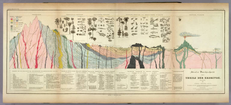
Berghaus, Heinrich
Full Title
Idealer Durchschnitt eines Theils Der Erdrinde. Verfafst von Thomas Webster, F.G.S. &c. Die Pflanzen und Thiere nach der Auswahl und Anordnung des Dr. Buckland gezeichnet von Joseph Fischer. Potsdam, gestochen in der geographischen Kunstschule, die Figuren von J.C. Ausfeld. 3te Abtheilung: Geologie, No. 11. Gotha, J. Perthes, 1841.
List No
2515.038
Note
A full color "ideal" geologic cross section with a detailed key explaining all of the notations on the map. Above the section are numerous drawings of plants, animals, and sea life.
Author
Berghaus, Heinrich
Full Title
Geologische Profile von Deutschland im Allgemeinen u. von Riesengebirge im Besondern; Sammt Einer Karte vom Tertiar Becken von Paris. 3te Abtheil: Geologie, No. 14. Gezeichnet von H. Credner. Gest. v. E.G. Edler. Gotha, bei J. Perthes, 1845.
List No
2515.041
Note
A full color geologic map of France and numerous full color geologic cross sections of Germany. A key is included.
Author
Berghaus, Heinrich
Full Title
Umrisse Der Pflanzengeographie. 5te Abtheilung: Pflanzengeographie, No. 1. Gezeichnet von Fr. Schelle. Gestochen von Joh. Carl Ausfeld. Gotha, J. Perthes, 1838.
List No
2515.048
Note
Map in full color shows the distribution of vegetation throughout the world. Five drawings above the map show the vegetation in numerous areas including the Andes, Himalayas and the Alps. Page includes a large key, statistical information and drawings of plants.
Author
Berghaus, Heinrich
Full Title
Verbreitungsbezirke Der Wichtigsten Kulturgewachse; Nebst Andeutungen Uber Den Lauf Der Isotheren Und Isochimenen. 5te Abtheilung: Pflanzengeographie, No. 2. Potsdam, in der geograph. Kunstschule. Gestochen von Joh. Carl Ausfeld. Gotha, J. Perthes, 1839.
List No
2515.049
Note
In full color. Large map shows the distribution of grains throughout the world. This map is flanked by drawings of a large variety of plants. Four smaller maps show the distribution of other goods such as sugar, coffee, pepper, tea, and vanilla.
Author
Berghaus, Heinrich
Full Title
Tabellarische Darstellung Der Statistik Des Gewachsreich's In Europa. 5te Abtheilung: Pflanzengeographie, No. 3. Gotha, bei J. Perthes; 1839. Gedruckt im Decker'schen Geheimen Ober-Hofbuchdruckerei-Etablissement in Potsdam.
List No
2515F
Note
A statistical table detailing the types and distribution of plants throughout Europe.
Author
Berghaus, Heinrich
Full Title
Geographische Verbreitung: Vierhandige Saugethiere, Quadrumana: Affen und Halbaffen. Beutel-Thiere, Marsupialia. _Edentata, Zahnlose Thiere. Dickhauter, Pachydermata. 6te. Abtheilung: Geographie der Thiere No. 1. Gez. in der geogr. Kunstschule zu Potsdam. Gestochen von Joh. Carl Ausfeld zu Meiningen. Gotha, bei J. Perthes, 1845.
List No
2515.053
Note
Maps without color, but with themes outlined in color. Map surrounded by the animals indiginous to each region.
|