Author
Popple, Henry
Full Title
A Map of the British Empire in America with the French and Spanish Settlements adjacent thereto. by Henry Popple. (Sheet 15).
List No
2874.017
Note
Hispaniola and the Leeward Islands shown. Also includes dedication within an elaborate cartouche, which reads: "To the Queen's Most Excellent Majesty This Map is most humbly Inscribed by Your Majesty's most Dutiful, most Obedient, and most Humble Servant, Henry Popple." The coat of arms is different than the one on the cover (King George II).
Author
Popple, Henry
Full Title
A Map of the British Empire in America with the French and Spanish Settlements adjacent thereto. by Henry Popple. (Sheet 16).
List No
2874.018
Note
Right edge of row four includes five uncolored inset maps: The Havana, Bay of St. Iago in Cuba, Kingston Harbour in Jamaica, A Plan of the Harbour of Port Antonio in Jamaica, and Fort Royal in Martinica.
Author
Popple, Henry
Full Title
A Map of the British Empire in America with the French and Spanish Settlements adjacent thereto. by Henry Popple. (Sheet 19).
List No
2874.021
Note
Northern South America is shown. Section also includes the Windward Islands. Uncolored.
Author
Popple, Henry
Full Title
A Map of the British Empire in America with the French and Spanish Settlements adjacent thereto. by Henry Popple. (Sheet 20).
List No
2874.022
Note
Final panel in the series with the authentication statement of Edmund Halley and four inset maps. Maps include: The Island of Barbadoes, Antigua, Cartagene on the Coast of New Spain, and Harbour of Porto Bello. Uncolored. Publisher's statement below border at right.
Author
Arrowsmith, Aaron
Full Title
Map of America by A. Arrowsmith, Hydrographer to H.R.H. the Prince of Wales. 1804. W. & G. Cooke, Sculp. London. Published 4th September 1804 by A. Arrowsmith No. 10 Soho Square ... Engraved by W. West, the Hills by H. Wilson.
List No
2286.000
Note
Dissected, 4 sheets, each into 6 sections. 1804 on title; paper watermarked 1811. Tooley (Printed Maps of America) lists editions: 1804, 1804(1808), 1804(1811), 1822, 1822 additions to 1824, 1840. He does not list the American edition of c.1812, Philadelphia. Maps fold and lie in a new gray cloth folding case 34.5x27 with "Map Of America A. Arrowsmith 1811" stamped on the spine in gilt.
Author
Melish, John
Full Title
Map of the United States with the contiguous British & Spanish Possessions Compiled from the latest & best Authorities By John Melish. Engraved by J. Vallance & H.S. Tanner. Entered ... 16th day of June 1820. Published by James Finlayson Agent Philada. Successor to John Melish, Improved to 1823. (inset) West Indies.
List No
3948.000
Note
The last edition of Melish's map of the United States, first published in 1816, and the 25th state identified by Martin/Ristow. This edition has the three additional sheets at the bottom of the map (added in the second state of the 1822 edition) that expand the coverage of Mexico and the West Indies. Compared to the first 1816 edition, there are many changes in the Great Plains area of the U.S. (that first appeared in the 1822 edition) based on Long's Map of 1822 (although Melish does not mention Long in his preface to the Geographical Description edition of 1822). Ristow (A la Carte) says there are no changes between between the 1823 edition and the second state of the 1822 edition, other than the change in publisher and date. Outline color by state or territory. The map is dissected into 50 sections, backed with linen, and edged in white silk. It folds into a new dark blue cloth folding case 25x17 with black ties; the spine is embossed with "Map Of The United States. John Melish. 1823" in gold.
Author
Arrowsmith, Aaron
Full Title
Chart Of The West Indies And Spanish Dominions In North America. By A. Arrowsmith, 1803. Jones Smith & Co. sc. Beaufort Buildgs. Strand. London Published June 1st 1803 by A. Arrowsmith No. 24 Rathbone Place. To Admiral John Willett Payne, A distinguished Native of the West Indies ... This Chart is respectfully Dedicated by his most obedient Servt. A. Arrowsmith.
List No
4121.000
Note
The first edition, including Mexico to the Pacific, and with the dedication to Admiral John Willett Payne. In four sheets. Countries are outlined in color. The 1810 second and later editions only extend to the east coast of Mexico, presumably because Arrowsmith published his large map of Mexico in 1810. In its coverage of Mexico and Central America, this map is the largest scale and most accurate map of those areas published to date, preceding Pike's and Humboldt's maps by several years. It seems odd that Humboldt would criticize Arrowsmith for copying his map of New Spain, when Arrowsmith produced his own map (this West Indies Map) which included substantial portions of Mexico several years before Humboldt's map was issued. There are many differences between this map's rendering of Mexico and the 1810 Map of Mexico - the later map has more and better detail, but the earlier rendition is still impressive. Stevens and Tree only list two editions, 1803 and 1810, but Phillips lists an 1811 (P-Maps) and an 1816 (atlases). There probably were others.
Author
Mitchell, Samuel Augustus
Full Title
Map of North America Engraved to Illustrate Mitchell's School and Family Geography. No. 3. Engraved by J.H. Young. Entered ... 1839, by S. Augustus Mitchell ... Connecticut.
List No
0523.002
Note
In full color by country. Note included explaining the notations used on the map.
Author
Robert Sayer and John Bennett (Firm)
Full Title
A Compleat Map of the West Indies, Containing the Coasts of Florida, Louisiana, New Spain, and Terra Firma: with all the Islands. By Samuel Dunn, Mathematician. London: Printed for Robt. Sayer ... 10 January 1774.
List No
0875.002
Note
In outline color by country or European ownership.
Author
Colton, J. H.
Full Title
Map Of The United States Of America, The British Provinces, Mexico and the West Indies, Showing The Country from the Atlantic to the Pacific Ocean. Published by J.H. Colton, No. 86 Cedar St. New York. 1848. Entered ... 1846, by Joseph H. Colton ... New York. Drawn & Engraved By Sherman & Smith New-York. (inset) The south Eastern Part Of The West Indies. (inset) Map Of Newfoundland.
List No
3960.001
Note
Third edition, first being 1846 (according to Ristow, although Karrow only lists an 1847). Texas is still in large configuration with a panhandle running up to Oregon. California and the Great Basin are shown only as Upper or New California. Fremont's 1843 and 1845 maps are incorporated, but not the 1848 map. The title is in the lower left, with an inset map of the West Indies and an inset of Newfoundland. In the 1850 edition the title is moved to the upper right. In the 1853 edition it is moved to the upper left. Map is dissected into 16 sections and edged in pink silk. Full color by state. Folds into green and pink plaid end sheets and half leather marbled covers 38x35 with ties and a label reading "United States" in elegant manuscript.
Author
May, B. y Ca.
Full Title
Mapa Historico Pintoresca Moderno de al Isla De Cuba. (with) 16 inset views of Cuba.
List No
5445.000
Note
Lithographic color map with an inset table of distances from principle cities with their longitude and latitude noted. Views of cities, ports, and events such as cock fighting and the aftereffects of an 1846 hurricane surround the map. Date estimated.
Author
May, B. y Ca.
Full Title
Plano Pintoresco De La Habana con los numeros de las casas B. May y Ca. 1853. (with) Inset map Puerto y Cereanias De La Habana. (with) 14 views of Havana & prominent buildings.
List No
5444.000
Note
Colored lithographic map with views of the city of Havana including the "Fuente De La India En El Paseo De Isabel 2a." and "Vista Gral De La Habana." Text on map discusses the number of houses in the city.
Author
Tanner, Henry S.
Full Title
South America and West Indies. 1818. (northern section) Drawn, Engraved & Published by Tanner, Vallance, Kearney & Co. Philadelphia. American Atlas.
List No
5388.006
Note
Northern section of South America. Southern section is on following page. In full color.
Author
Tanner, Henry S.
Full Title
(Composite Map) South America and West Indies. 1818. Drawn, Engraved & Published by Tanner, Vallance, Kearney & Co. Philadelphia. Entered ... 8th day of June, 1818, by Tanner, Vallance, Kearney & Co. ... Pennsylvania. American Atlas.
List No
5388.008
Note
In full color.
Author
Tanner, Henry S.
Full Title
A Map of North America, Constructed According To The Latest Information: by H.S. Tanner. S.E. Sheet. (with) Comparative Altitudes of the Mountains, Towns &c of North America. Entered ... 27th day of May 1822, by H.S. Tanner ... Pennsylvania. Engraved & Published by H.S. Tanner. Philadelphia. 1822. Printed by Wm. Duffee. American Atlas.
List No
5388.012
Note
Fourth of four sheets comprising the North American map. Scale measured at 10 degrees latitude. In full color. This section includes the comparative altitude map, and two scales for latitude and longitude.
Author
Tanner, Henry S.
Full Title
(Composite of) A Map of North America, Constructed According To The Latest Information: by H.S. Tanner. S.E. Sheet. Entered ... 27th day of May 1822, by H.S. Tanner ... Pennsylvania. Engraved & Published by H.S. Tanner. Philadelphia. 1822. Printed by Wm. Duffee. American Atlas.
List No
5388.013
Note
Composite of the four North American map sheet. Scale measured at 10 degrees latitude. In full color.
Author
Andriveau-Goujon, E.
Full Title
Carte Generale Des Etats - Unis Et Du Mexique Comprenant L'Amerique Centrale Et Les Antilles. E. Andriveau-Goujon, Editeur. Paris, Rue Du Bac, 21. 1865 ... (with four inset maps).
List No
2100.001
Note
Third edition. Shows Colona, Shoshone, Nevada. The maker of this map must have seen copies of Mitchell's 1859 New National Map - this has the same proposed territorial names that Mitchell used that year. This also has a line dividing the northern and southern states in the civil war. According to Phillips Maps, this was also No. 48 in the Atlas Universel for 1862. Map is dissected into 21 sections and mounted on tan linen with the book plate of Andriveau-Goujon. Covers are dark green cloth 23.5x14.5 with "Etats-Unis Et Mexique. Andriveau-Goujon. Rue Du Bac, 2I." stamped in gold on the front with the same embossed gold and green globe as the 1862 issue. The spine is stamped with "Etats-Unis" in gold. Map has full color by state.
Author
Atwood, J.M.
Full Title
Map Of The United States, Canada, Mexico, Central America, and the West India Islands With a Portion of Venezuela & New Granada; Showing the routes overland and by the Isthmus to California and Oregon, Also the new Boundaries of California, Utah, & New Mexico, Compiled from the latest Authorities. Engraved & Published By J.M. Atwood, No. 19 Beekman Street, New York. 1851. D. McLellan, Printr. Spruce St ... Entered ... 1851, by J.M. Atwood ... New York.
List No
2365.001
Note
Shows the Gold Regions in California. Atwood made important maps of the Gold Rush for Colton and Ensign & Thayer in 1849. In this map he publishes his own Gold Rush map, showing the routes to California and Oregon. This map is rare: it is not in Philips, Karrow, Wheat, Streeter, Graff, or nine years of Jolly. Wheat Gold 258 is an 1854 derivative of this map put out by Ensign, Bridgman & Fanning. This 1851 map is very well done, and possibly the only map that Atwood published under his own name. See our 2878 and 3209 for related maps. Full color. Folded into red embossed cloth covers 14.5x9.5 with title "Map Of The United-States Canada, Mexico, Central America And The West India Islands" stamped in black.
Author
Colton, G.W.
Full Title
West Indies. (with) two inset maps: The Bermuda Islands and City & Harbor Of Havana. Published By J.H. Colton & Co. No. 172 William St. New York. Entered ... 1855 by J.H. Colton & Co. ... New York. No. 56.
List No
0149.061
Note
In full color.
Author
Colton, G.W.
Full Title
Cuba, Jamaica And Porto Rico. (with) Porto Rico. Published By J.H. Colton & Co. No. 172 William St. New York. Entered ... 1855 by J.H. Colton & Co. ... New York. No. 57.
List No
0149.062
Note
In full color. List includes references to the parishes in Jamaica.
Author
Colton, G.W.
Full Title
Brazil And Guayana (with) two inset maps: Pernambuco and Rio de Janeiro. Published By J.H. Colton & Co. No. 172 William St. New York. Entered ... 1855 by J.H. Colton & Co. ... New York. No. 61.
List No
0149.066
Note
In full color by region.
Author
Colton, J. H.
Full Title
Map Of The United States Of America, The British Provinces, Mexico, the West Indies and Central America, with part of New Grenada and Venezuela. New York, Published By J.H. Colton, No. 86 Cedar St. 1849. Map Drawn by Geo. W. Colton, Engraved by John M. Atwood, Border Desigd. & Engd. by W.S. Barnard. Entered ... 1848 by J.H. Colton ... New York. (inset) A Map Of The Atlantic Ocean Showing The American & European Ports and the Routes Of The Ocean Steamers.
List No
5535.001
Note
This is Thomas Streeter's copy of this important map, identified as such by the inclusion of his handwriting on the inside cover, and the words "Louis Billon 1849" in ink on the inside front cover and verso of map. The border includes twelve views. As noted in Streeter, "This later issue of lot 3873 differs in the binding and in showing not only the 'Gold Region' near New Helvetia, but also 'El Dorado or Gold Region' along the Feather River. It also has quite an extensive 'Table of Distances' added at the right of the inset." This is the second 1849 edition, which was also produced as a wall map (see our #4312). In this edition Fremont's route is shown along the Humboldt River, and California has been extensively remapped. Map is in full color and folds into the original blind-stamped covers, 16x11, with the title "Colton's Map of the United States Mexico &c." in gilt on the front cover.
Author
Humboldt, Alexander von, 1769-1859
Full Title
Carte Du Mexique et des Pays Limitrophes Situes Au Nord et a l'est Dressee d'apres la Grande Carte de la Nouvelle Espagne De Mr. A. De Humboldt et d'autres Materiaux par J.B. Poirson. 1811. 2. Grave par Barriere. et l'ecriture par L. Aubert. Se trouve a Paris chez F. Schoell, Libraire.
List No
0328.004
Note
An uncolored map of Mexico, the United States and the West Indies.
Author
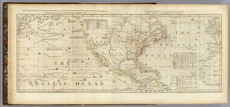
Jefferys, Thomas
Full Title
Chart containing the Coasts of California, New Albion, and Russian Discoveries to the North, with the Peninsula of Kamtschatka, in Asia, opposite thereto; And Islands, dispersed over the Pacific Ocean, to the North of the Line. North America and The West Indies, with the opposite Coasts of Europe and Africa. Published ... 10 June 1775, by R. Sayer & J. Bennett ... Fleet Street. IV.
List No
0346.002
Note
In outline color. Map has extensive notes and charts noting variations in latitudes and longitudes noted by different observations. Tracks of the ships in the Pacific Ocean shown along with relevant dates.
Author
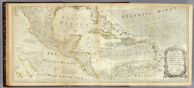
Jefferys, Thomas
Full Title
An Accurate Map Of North America. Describing and distinguishing the British and Spanish Dominions on the great Continent; According to the Definitive Treaty Concluded at Paris 10th Feby. 1763. Also all the West India Islands Belonging to, and possessed by the Several European Princes and States. The whole laid down according to the latest and Most authentick Improvements, By Eman Bowen Gegr: to His Majesty and John Gibson Engraver. (with) inset map of The Passage by Land To California, Discovered by Father Eusebius Francis Kino a Jesuit. London. Printed for Robert Sayer No. 53 Fleet Street as the Act Directs 2d. July 1775.
List No
0346.007
Note
In outline color with elaborate cartouche giving seven different scales and an explanation of the symbols used. Article XX of the Treaty is included on this southern section of the map.
Author
Jefferys, Thomas
Full Title
(Composite of) An Accurate Map Of North America. Describing and distinguishing the British and Spanish Dominions on the great Continent; According to the Definitive Treaty Concluded at Paris 10th Feby. 1763. Also all the West India Islands Belonging to, and possessed by the Several European Princes and States. The whole laid down according to the latest and Most authentick Improvements, By Eman Bowen Gegr: to His Majesty and John Gibson Engraver. London. Printed for Robert Sayer No. 53 Fleet Street as the Act Directs 2d. July 1775.
List No
0346.008
Note
In outline color with elaborate cartouche giving seven different scales and an explanation of the symbols used. Treaty reproduced along the right side of the large outline color map.
Author
[Jefferys, Thomas, Holland, Samuel, 1728-1801]
Full Title
A Map of the Island of St. John In the Gulf of St. Laurence Divided Into Counties & Parishes And the Lots, as granted by Government, to which are added The Soundings round the Coast & Harbours, Improv'd from the late Survey of Captain Holland. Published as the Act direct April 6, 1775. XIII. (with) inset map of the Gulf of St. Laurence.
List No
0346.013
Note
In outline color by Parish. Each Parish divided into numbered lots. Chart above map lists the lots and proprietors' names. Acreage of lots also included in separate chart. Background tinted gray.
Author
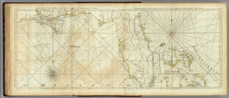
Jefferys, Thomas
Full Title
The Coast Of West Florida and Louisiana By Thos. Jefferys Geographer to His Majesty. (and) The Peninsula and Gulf of Florida or Channel of Bahama with the Bahama Islands. By Thos. Jefferys Geographer to His Majesty. London. Printed for Robt. Sayer ... 20 Feby. 1775.
List No
0346.029
Note
In outline color by state or island. Titles appear above the border on either side of the center of the map. Soundings and rhumblines shown in the gulf and ocean. Flotillas are shown in the Gulf of Florida and the Gulf of Mexico with that group following a track to avoid the Trade Winds on the way to Havana.
Author
Jefferys, Thomas
Full Title
(Composite of) A Map Of South America Containing Tierra-Firma, Guayana, New Granada, Amazonia, Brasil, Peru, Paraguay, Chaco, Tucuman, Chili and Patagonia. from Mr. D'Anville with Several Improvements and Additions, and The Newest Discoveries. London. Printed for Robert Sayer, No. 53, Fleet Street as the Act Directs 20 September 1775.
List No
0346.034
Note
Southern part includes a long descriptive passage entitled, "Division of South America with Summary Account of its Trade." Discoveries shown and limited information about the people and languages of the interior is included.
Author
Mitchell, Samuel Augustus
Full Title
West Indies.
List No
0537.038
Note
In full color.
Author
Mitchell, Samuel Augustus
Full Title
Map Of Mexico, Central America, And The West Indies. 40. Constructed & Engraved by W. Williams Philadelphia. (with) four inset maps: Map of the Island of Cuba. 41. ... Island of Jamaica. 42. ... Bermuda Islands. 43. ... Panama Railroad. 44. Entered ... 1860, by S. Augustus Mitchell, Jr. ... Pennsylvania.
List No
0565.028
Note
In full color by country and county.
Author
Morse, Jedidiah
Full Title
A Map of the West Indies from the best Authorities. Published July 9, 1794 by I. Stockdale, Piccadilly.
List No
0632.024
Note
Uncolored.
Author
[U.S. War Department, Weyss, John E.]
Full Title
Bermuda Hundred. From Surveys under the direction of Bvt. Brig. Gen N. Michler, Maj. of Engineers and Bvt. Lieut. Col. P.S. Michie, Capt. of Engineers By Command of Bvt. Maj. Genl. A.A. Humphreys, Brig. Genl. & Chief of Engineers. 1867. Surveyed & drawn by Maj. J.E. Weyss, assisted by F. Theilkuhl, J. Strasser & G. Thompson. Photolith. by the N.Y. Lithographing, Engraving & Printing Co., Julius Bien, Supt.
List No
3881.010
Note
Full printed color.
Author
Bradford, Thomas G.
Full Title
North America. Entered ... 1838, by T.G. Bradford ... Massachusetts. Engraved by G.W. Boynton.
List No
0089.002
Note
Map in full color.
Author
Bradford, Thomas G.
Full Title
West Indies. (inset) Bermudas. Entered ... 1838, by T.G. Bradford ... Massachusetts. Engraved by G.W. Boynton.
List No
0089.039
Note
In full color.
Author
Finley, Anthony
Full Title
The West Indies from the Best Authorities. J.H. Young Sc. Philadelphia Published by A. Finley 1826.
List No
0278.014
Note
In full color by island. Statistical table lists the total population and whites for each island, the chief towns and to whom the island belongs.
Author
Johnson, A.J.
Full Title
Johnson's Cuba Jamaica And Porto Rico. By Johnson & Browning. (with) two inset maps: Porto Rico and the City & Harbor Of Havana. No. 51.
List No
2905.034
Note
In full color. Reference to the parishes in Jamaica is included.
Author
Bowen, Emanuel
Full Title
A new and accurate map of Terra Firma and the Caribbe Islands. Drawn from the most approved modern maps & charts, & adjusted by astronl. observatns. By Eman. Bowen. (London: Printed for William Innys, Richard Ware, Aaron Ward, J. and P. Knapton, John Clarke, T. Longman and T. Shewell, Thomas Osborne, Henry Whitridge ... M.DCC.XLVII)
List No
3733.055
Note
Engraved map. Includes geographical and historical notes and ornamental cartouche. Relief shown pictorially.
Author
Bowen, Emanuel
Full Title
An accurate map of the West Indies. Drawn from the best authorities, assisted by the most approved modern maps and charts, and regulated by astronomical observations. By Eman: Bowen. (London: Printed for William Innys, Richard Ware, Aaron Ward, J. and P. Knapton, John Clarke, T. Longman and T. Shewell, Thomas Osborne, Henry Whitridge ... M.DCC.XLVII)
List No
3733.056
Note
Engraved map. Shows sailing tracks, currents, shoals, etc. Includes historical notes and ornamental cartouche. Relief shown pictorially. Located before p. 741.
Author
Bowen, Emanuel
Full Title
A new & accurate map of Mexico or New Spain together with California, New Mexico &c. Drawn from the best modern maps & charts & regulated by astronl. observns. By Eman: Bowen. (London: Printed for William Innys, Richard Ware, Aaron Ward, J. and P. Knapton, John Clarke, T. Longman and T. Shewell, Thomas Osborne, Henry Whitridge ... M.DCC.XLVII)
List No
3733.057
Note
Engraved map. Shows shoals, etc. Includes historical note on California and ornamental cartouche. Relief shown pictorially. Inset map: The Gallipago Islands : discovered & described by Capt. Cowley in 1684. Scale [ca. 1:5,000,000]
Author
Bowen, Emanuel
Full Title
A new & accurate map of Bermudas or Sommer's Islands ... ; An accurate map of the Island of St. Christopher, vulgarly called St. Kits ... By Eman. Bowen. (London: Printed for William Innys, Richard Ware, Aaron Ward, J. and P. Knapton, John Clarke, T. Longman and T. Shewell, Thomas Osborne, Henry Whitridge ... M.DCC.XLVII)
List No
3733.063
Note
2 maps on 1 sheet. Engraved. Show rocks, shoals, etc. Include geographical notes. Has 2 ornamental cartouches. Relief shown pictorially.
Author
Bowen, Emanuel
Full Title
A new & accurate map of the island of Cuba. Drawn from the most approved maps & charts ... ; A new & accurate map of the islands of Hispaniola or St. Domingo, and Porto Rico. Drawn from the most approved maps & charts ... By Eman. Bowen. (London: Printed for William Innys, Richard Ware, Aaron Ward, J. and P. Knapton, John Clarke, T. Longman and T. Shewell, Thomas Osborne, Henry Whitridge ... M.DCC.XLVII)
List No
3733.064
Note
2 maps on 1 sheet. Engraved. Show rocks, banks, etc. Include geographical note. Has 2 ornamental cartouches. Relief shown pictorially.
Author
Bowen, Emanuel
Full Title
A new & accurate map of the island of Jamaica. Divided into its principal parishes. Drawn from surveys and regulated by astronl. observatns. By Eman. Bowen. (London: Printed for William Innys, Richard Ware, Aaron Ward, J. and P. Knapton, John Clarke, T. Longman and T. Shewell, Thomas Osborne, Henry Whitridge ... M.DCC.XLVII)
List No
3733.065
Note
Engraved map. Show churches, sugar and indigo works, cotton and provisions, "cocoa walk," crawles for hogs, pens for cattle, etc. Has ornamental cartouche. Relief shown pictorially. Inset maps: A draught of the Harbour of Port Antonio & St. Francis ... -- A draught of Port Royal, or Kingston Harbour in Jamaica.
Author
Bowen, Emanuel
Full Title
A new and accurate map of the island of Antigua or Antego, taken from surveys, and adjusted by astronl. observations. Containing all the towns, parish churches, forts, castles, windmills, roads &c. By Eman. Bowen. (London: Printed for William Innys, Richard Ware, Aaron Ward, J. and P. Knapton, John Clarke, T. Longman and T. Shewell, Thomas Osborne, Henry Whitridge ... M.DCC.XLVII)
List No
3733.066
Note
Engraved map. Shows shoals, rocks under water, sugar works, cattle mills, etc. Has geographical notes and ornamental cartouche. Relief shown pictorially; depths by soundings.
Author
Bowen, Emanuel
Full Title
Particular draughts and plans of some of the principal towns and harbours belonging to the English, French, and Spaniards, in America and West Indies. Collected from the best authorities, by Eman. Bowen. (London: Printed for William Innys, Richard Ware, Aaron Ward, J. and P. Knapton, John Clarke, T. Longman and T. Shewell, Thomas Osborne, Henry Whitridge ... M.DCC.XLVII)
List No
3733.067
Note
Thirteen maps on 1 sheet. Engraved. Relief shown pictorially; depths by soundings. Contents: A draught of Boston Harbour -- A draught of New York and Perthamboy Harbour -- Fort Royal in Martinico -- The Harbour of Placentia -- The Harbour of Anapolis Royal -- Harbour of St. Augustine -- The Harbour of Providence -- The Havana -- Bay of St. Iago in Cuba -- A plan of the Town and Harbour of Cartagena -- A plan of the town and harbour of Louisbourg in the island of Cape Breton ... -- The town and harbour of Charles Town in South Carolina. Scale (ca. 1:12,000) -- A Plan of the Harbour Town and forts of Porto Bello, when taken by Admiral Vernon on Novr. 22d. 1739 with 6 ships only.
Author
Bowen, Emanuel
Full Title
An accurate map of the Island of Barbadoes. Drawn from an actual survey containing all the towns, churches, fortifications, roads, paths, plantations &c. By Eman. Bowen. (London: Printed for William Innys, Richard Ware, Aaron Ward, J. and P. Knapton, John Clarke, T. Longman and T. Shewell, Thomas Osborne, Henry Whitridge ... M.DCC.XLVII)
List No
3733.068
Note
Engraved map. Relief shown pictorially. Includes table of parish acreages and ornamental cartouche.
Author
[Bradford, Thomas G., Goodrich, S.G.]
Full Title
West Indies. (with) Bermudas. Engraved by G.W. Boynton. Entered ... 1838, by T.G. Bradford ... Massachusetts.
List No
4453.041
Note
Full color by island.
Author
Arrowsmith, John
Full Title
America, By J. Arrowsmith. (Map) 39. London, Pubd. 15 Feby. 1844, by J. Arrowsmith, 10 Soho Square.
List No
4613.039
Note
In outline color.
Author
Arrowsmith, John
Full Title
West Indies, By J. Arrowsmith. (with) inset map of the northern section of Guatimala (sic) (Map) 45. London, Pubd. 15 Feby. 1842, by J. Arrowsmith, 10 Soho Square.
List No
4613.045
Note
In outline color. Note includes a proposed route for a canal across Guatemala.
Author
Arrowsmith, John
Full Title
Colombia, Dedicated to Colonel Belford Hinton Wilson, late Aid de Camp to the Liberator Simon Bolivar, By his Obliged Servant J. Arrowsmith. (Map) 47. London, Pubd. 15 Feby. 1842, by J. Arrowsmith, 10 Soho Square.
List No
4613.047
Note
In outline color.
|