|
REFINE
Media Group: Kerry Chambers 2
1-62 of 62
Author
Bachmann, John
Full Title
Panorama of the Seat of War. Birds Eye View Of Florida And Part Of Georgia And Alabama. John Bachmann, Publisher, 115 & 117 Nassau St., New York. Entered ... 1861 by John Bachmann ... New York. Drawn from Nature and Lith. by John Bachmann.
List No
2665.001
Note
Shows entire Florida Peninsula. See Stephenson page 15 for a general discussion of Bachmann's civil war views. In addition to the six panoramas of the seat of war, Bachmann did a view of Richmond (Stephenson 621, illustrated p271), and of the junction of the Ohio and Mississippi Rivers (Stephenson 1.5) - which may be similar to the Kentucky - Tennessee Seat of War view, at least in terms of vantage point. Full color. Bound in black leather covers 38x30 with "Florida & Part Of Georgia & Alabama. G.G.W." stamped in gold.
Author
Reid, John
Full Title
Plan of the City of Washington in the Territory of Columbia ceded by the States of Virginia And Maryland to the United States of America and by them established as the Seat of their Government, after the Year 1800. Rollinson sculp. N. York. Published by J. Reid L. Wayland and C. Smith 1795.
List No
5160.000
Note
State I of this map (State II lists only J. Reid as publisher). This map is taken from the first official plan of Washington published by Andrew Ellicott in 1792 (see Wheat & Brun 531). The Reid map is not an exact copy, with the title moved from the upper right to the lower left, several notes not included, and other elements moved. An exact copy of Reid's map appears in the London edition of Winterbotham's "View of the United States of America" (see our #3885). Howes gives precedence to the London edition, so it is not clear if Reid or Russell copied the Ellicott first. The Reid American Atlas index does not call for the Washington map, leading to the assumption that it was added to some copies afterwards, and speculation that it may have been sold as a separate. Scarce.
Author
Ensigns & Thayer
Full Title
Map of the Gold Regions of California, Showing the Routes via Chagres and Panama, Cape Horn, &c.
List No
4683.000
Note
This is the thin paper copy with smaller ornamental border and no publisher credit. Wheat believes it was folded into some copies of Farnham's "Life, Adventures, and Travels in California;" our copies of that book have the Haven map pasted in one (see our #3963) and this map pasted in the other (see our #5001). This copy shows signs of being folded. It was probably sold with the book and separately. The text is the same as the broadside issue but the title is in different type. Scarce.
Author
United States Coast Survey
Full Title
Entrance to San Francisco Bay California. From a Trigonometrical Survey under the direction of A.D. Bache Superintendent of the Survey Of The Coast Of The United States. Triangulation by R.D. Cutts Asst. & A.F. Rodgers Sub-Assts. Hydrography by the Party under the command of Lieut. Comdg. James Alden U.S.N. Asst. 1859. U.S. Coast Survey Office. Verified W.R. Palmer ... No. 36. Redd. Drng. by W.M.C. Fairfax, J. Lambert, & J.J. Ricketts. Engd. by J. Knight, A. Blondeau & G.B. Metzeroth. Electrotype Copy No. 2 by G. Mathiot U.S.C.S. (inset map) Sub-Sketch Of Entrance To San Francisco Bay. 1859.).
List No
1032.000
Note
Light paper chart-full margins, shows plate marks. Map is without color.
Author
Fullarton, A. & Co.
Full Title
British Empire Throughout the World Exhibited In One View. Compiled By John Bartholomew Junr. F.R.G.S. A. Fullarton & Co. Edinburgh, London & Dublin.
List No
3007.023
Note
This double page map is titled "British Empire Throughout The World Exhibited In One View." The British possessions are colored in red as was typical of maps of the period showing the British Empire. It is highly decorative and it appeared in Fullarton's Royal Illustrated Atlas which was first published in 1864 after being issued in 27 parts from 1854-62. Map surrounded by drawings of the inhabitants of each dominion. Tables include size and population of nations around the world.
Author
Jackson, William A.
Full Title
Map Of The Mining District of California by Wm. A. Jackson. Published by Lambert & Lane, 69 Wall St. New York. Entered ... 1851 by Lambert & Lane ... New York. (with 16 page appendix) Appendix To Jackson's Map Of The Mining Districts Of California. ... Second Edition, Revised And Enlarged. New-York: Lambert & Lane, 69 Wall-Street. 1851.
List No
2545.001
Note
This is one of the most attractive of the California Gold Rush period maps. Here it is published in pocket map form, with the 16 page "Appendix to Jackson's Map..." which describes the important mining centers. More ornate and detailed than Jackson's map of 1850, this is the only map to label Santa Cruz county "Branciforte." Shows for the first time, some of the mining activity in the south, which Jackson was involved with as an engineer. Map is full color by county, folded into dark green cloth covers 15x10 with "Jackson's Map Of The Mining Districts Of California" stamped in gilt.
Author
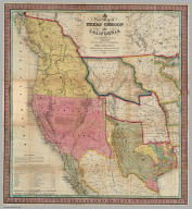
Mitchell, Samuel Augustus
Full Title
A New Map of Texas Oregon and California With The Regions Adjoining. Compiled from the most recent authorities. Philadelphia Published by S. Augustus Mitchell N.E. Corner Of Market & Seventh Streets. 1846. Entered ... 1845 by H.N. Burroughs ... Pennsylvania.
List No
0534.001
Note
With 46 page "Accompaniment to Mitchell's New Map Of Texas, Oregon, and California With The Regions Adjoining;" the full color map is folded into stamped black leather covers 13.5x8 with "Texas, Oregon And California" in gilt. This was one of Mitchell's most popular and important pocket maps. Later editions were published in 1849, 1851, and 1852, as pocket maps and as insets to the large Reference and Distance Map of the United States. It was also issued separately as a wall map. This issue has Texas colored green; some copies have Texas colored brown (has the green changed over time?). The text has a catalogue for Mitchell's publications. Mitchell first issued this map as an inset to his Reference and Distance Map of the United States in the 1846 edition (see our copy).
Author
[Darton, William, Gardner, W.R.]
Full Title
New and Improved View of the Comparative Heights of the Principal Mountains and Lengths of the Principal Rivers In The World, The whole Judiciously arranged from the various Authorities Extant. By W.R. Gardner. London: William Darton, 58 Holborn Hill, 10 Mo. 23rd, 1823. W.R. Gardner Sculpt. 367 Strand.
List No
4608.001
Note
This may be the earliest chart to depict the heights of mountains and the lengths of rivers together in one illustration, with the rivers hanging down over the mountains. Wolter says that Bulla's Tableau Comparatif of 1826 is the earliest of the combined mountain and river type, but he had not seen this chart by Gardner done three years earlier and does not list it. This chart is beautifully done and, while not large in size, it is impressive in its scope. Full color. Map is mounted on linen, dissected into 8 sections with an end sheet label reading "The Most Approved Modern Maps, Plans, And Charts, Of every Description, From The Best Authorities, Constantly on Sale at William Darton's Map, Print, and Chart Warehouse, 58, Holborn Hill, London..." Map folds into a dark green marbled cardboard case with a turquoise paper label printed with the map title (as above); there is a "William Darton's, Map seller" bookplate label on the back of the case.
Author
Ensign, Bridgman & Fanning
Full Title
World At One View. Ensign, Bridgman & Fanning, Publishers, 156 William St., New York. Entered...1854, By Ensign, Bridgman & Fanning...New York.
List No
5087.000
Note
This pictorial map gets larger with each issue: this 1854 edition is almost twice the size of the of the (1852) edition. More illustrations are added, including a large "Universal Dial Plate Or Times Of All Nations." A classic mid century graphic.
Author
Eddy, John H.
Full Title
Map Of The Country Thirty Miles Round the City of New York. Designed & Drawn by I.H. Eddy of N. York, 1812. To Dewitt Clinton Esqr. Mayor of the City of New York This Map is inscribed by his respectful friend The Author. Published by Prior & Dunning, Map & Chart sellers No. 111 Water Street. Copy Right secured according to Law. Engrd. by P. Maverick, Newark, N. Jersey.
List No
3472.000
Note
1st edition. Other editions of 1828, 36, 39, 42. Reengraved by Colton in 1846 (see our 1853 edition). Rare. Stokes: "This is one of the most complete, accurate, and beautiful early engraved maps showing New York and its environs." It was engraved by Peter Maverick. Stokes states that J. M. Atwood reengraved this map in 1846 for Colton (although the reengraving changed the map substantially). The 1828 reissue was in guide book form by Hooker and Blunt, Disturnell issued the 1836 and 39 editions (see our 1839 issue), and Goodrich issued the 1842 edition. Stokes dates the map at 1811 because of a reference to its publication in the October, 1811 issue of The American Medical and Philosophical Register. Eddy's name is written "I.H. Eddy" on the map, the "I" probably mistaken by the engraver for the "J." Map has outline color; dissected into 15 sections and mounted on linen. Folds with a gray marbled end sheet into a new gray cloth folding case 21x13 with "Thirty Miles Round New York J. Eddy 1811" stamped in gilt on the spine.
Author
[Mitchell, Samuel Augustus, Young, James H.]
Full Title
Map Of The United States By J.H. Young. Published by S. Augustus Mitchell. Entered ... Pennsylvania, October 10th, 1831 by S. Augustus Mitchell. Engraved by J.H. Young, D. Haines & F. Dankworth. (inset) A Map Of North America Including All The Recent Geographical Discoveries. (with 10 additional inset maps).
List No
2723.001
Note
1st edition, 1st wall map issued by Mitchell. This edition does not have the counties delineated and numbered. Ristow mistakenly says all editions have the townships (he means counties) numbered, but this one, the first, does not, thereby eliminating the index of counties and thus showing more of the western territory. This map predates the Traveler's Guide by 1 year, and thus is Mitchell's first "original" production, as opposed to the Finley material he reissued as the American Atlas and Pocket Maps. The case for the map has a leather label saying "Traveler's Map of the United States." Copyright date is October 10, 1831. There is no other date on the map. Ristow thinks the map was issued in early 1832, but it is not in Phillips until 1834 edition (which probably has the counties indicated by number and the 1831 copyright), so Ristow may not have seen this edition, but rather the 1834. The map is hand painted in bright full color by state (insets by county), dissected in 24 sections with green paper end sheets, mounted on linen and edged in pink silk. The covers 24x20 are half red leather marbled paper covered boards with ties and a leather label embossed with "Traveller's Map Of The United States" in gilt.
Author
[Blaskowitz, Charles, Faden, William, 1750?-1836]
Full Title
A Topographical Chart of the Bay of Narraganset in the Province of New England, with all the Isles contained therein, among which Rhode Island and Connonicut have been particularly Surveyed, Shewing the true position & bearings of the Banks, Shoals, Rocks &c. as likewise the Soundings: To which have been added the several Works & Batteries raised by the Americans. Taken by Order of the Principal Farmers on Rhode Island, By Charles Blaskowitz. Engraved & Printed for Wm. Faden, Charing Cross, as the Act directs, July 22d 1777. To the Right Honourable Hugh Earl Percy, Baron Percy, Lucy, Poinings, Fitz-Paine, Bryan & Latimer, Lieutenant General of His Majesty's Forces in Great Britain and America. This Plan is ... most humbly Inscribed, by ... Wm. Faden. (in manuscript) Hinck S.
List No
3951.001
Note
The most important map of the area around Providence and Newport issued during the Revolution. With hand painted color. A separately issued copy dissected into 16 sections and mounted on linen. Folds into a marbled slip case 24x17 with a paper label with "Rhode Island" printed in manuscript.
Author
Vincent
Full Title
Map Of The State Of California. Compiled from the most recent surveys and explorations Containing all the latest discoveries and newest towns. By Vincent. Printed by Mangeon S. Jacques St. Engraved by Ch. Smith. (inset) San Francisco and its surrounding localities. 1860.
List No
1124.000
Note
Unusual map showing California on its side with north to the left, an inset map and a beautiful view titled "Panorama Of San Francisco and Contra Costa." Full color by county.
Author
Wilson, James
Full Title
A three inch Terrestrial Globe by Wilson's & Co. Alby. (with) A Celestial Globe, With all the Stars of the 1st. 2d. & 3d. Magnitudes. By Wilson & Son's Alby.
List No
3122.000
Note
The date of the globes is an estimate. Paired with a three inch celestial globe. On a turned wooden stand with four black ball feet, full height from base to top, 5 inches. Warner says that Wilson changed the business name from Wilson & Co. to Wilson & Sons in 1822. The celestial globe this is paired with is by Wilson & Sons, so I assume 1822 as the only year globes were made with both business names. The globe is very well engraved, showing much detail in the continents for its small size. Longitude is given from both Washington and London. Kimball notes that David Wilson, James' son, did the engraving for a new edition of the three inch globes in the early 1820's, which I assume are these globes. David later had brief success as a miniature painter, utilizing the same delicate engraving skills which he applied to these extremely well engraved globes. The three inch globe was also sold in pocket form with the celestial sphere on the inside of the case and on a stand with horizon ring and brass meridian. On this turned wooden stand version, the globe is mounted horizontally, an unusual presentation. Wilson made the first globes in the United States, with 1810 his first year of production and 1850 (by Cyrus Lancaster) his last.
Author
Betts, John
Full Title
By The Queens Royal Letters Patent. Betts's New Portable Terrestrial Globe. Compiled from The Latest and Best Authorities. London, John Betts, 115 Strand.
List No
4362.000
Note
The first edition of Betts' collapsible 15-inch "umbrella" type globe. The date is estimated from the U.S. geography. Later editions continued to the end of the century. In the original wooden box with advertisements for Betts' geographical products. It is interesting that the color is printed onto the gores - thus being a fairly early example of color lithography.
Author
Quin, Edward
Full Title
A.D. 1498. The Discovery Of America. Engraved by Sidy. Hall Bury Strt. Bloomsby. London, Published by Seeley & Burnside, 169, Fleet Street, Jany. 1830.
List No
2839.016
Note
The fold out map shows clouds around the outer edges of the map depicting the known world from the division of the Mogul Empire, A.D. 1294, to the discovery of America, A.D. 1498. Sixteenth period. Africa is fully shown for the first time and the East Coast of America from Newfoundland to the northern edge of South America. The West Indies are shown in blue.
Author
Holdredge, Sterling M.
Full Title
(Illustrated Title Page to) State, Territorial and Ocean Guide Book of the Pacific: Containing The Time and Distance Tables ... on or Connecting with the Pacific Coast and the Interior ... To Which Are Added Nine Large and Reliable Maps Showing Principal Towns, Routes of Communication, etc. San Francisco: Published Semi-Annually by Sterling M. Holdredge. ... 1866.
List No
2544A
Note
Cowen p289. 2nd edition, 1st was 1865. Only two editions are known, 1865 and 1866 (Wheat). Wheat praised these maps and illustrated all nine. With a beautiful chromo litho title page illustrated with a globe showing the western hemisphere. Transportation scenes surround globe, including ships, a riverboat, train, and stagecoach. The nine maps are all double page and full of interesting information. They were lithographed by Grafton T. Brown, the first black lithographer in San Francisco. Rare. Book bound with cloth covers and "Guide Book of the Pacific" on the spine.
Author
Carver, Jonathan
Full Title
A New Map of North America, From the Latest Discoveries. 1778. Engrav'd for Carvers Travels.
List No
0131.001
Note
Map in color with the majority in outline color and the Midwest in full color. Stretches to Baffin Bay in the north.
Author
Darton, William
Full Title
(Covers to) A New Map of America, Dissected for the Instruction of Youth in Geography. (with) North America, from the Latest Authorities. Engraved by Willm. Darton. No. 58, Holborn Hill. Published Jany. 26, 1814 by Willm. Darton, London.
List No
3407A
Author
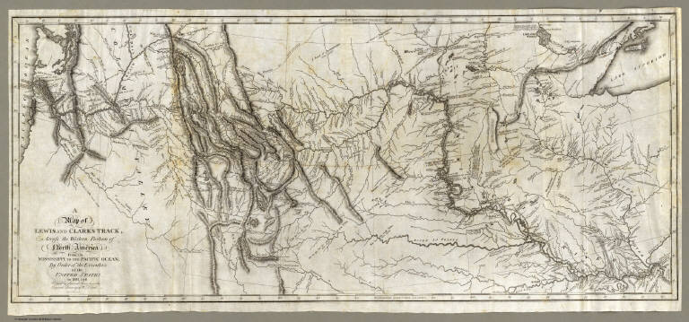
[Allen, Paul, Biddle, Nicholas, Clark, William, Lewis, Meriwether]
Full Title
A Map of Lewis and Clark's Track, Across the Western Portion of North America From the Mississippi to the Pacific Ocean; By Order of the Executive of the United States, in 1804, 5 & 6. Copied by Samuel Lewis from the Original Drawing of Wm. Clark. Smal. Harrison fct.
List No
3493.001
Note
Uncolored map showing topography and rivers in the region as well as towns, Indian villages, and population figures. Bound into the front of volume one.
Author
[Churchman, Joseph and James, Moore, I.W.]
Full Title
The Eagle Map of the United States Engraved for Rudiments of National Knowledge. 1833.
List No
4609.001
Note
The states shown in outline color with the eagle transparently sitting atop the nation.
Author
[Elmira Advertiser, G.W. & C.B. Colton & Co.]
Full Title
Supplement To The Elmira Advertiser. Map Of Chicago Showing The Burnt District. The City Of Chicago, Illinois. Published By G.W. & C.B. Colton & Co. 172 William St. New York. Entered ... 1855 by J.H. Colton & Co. ... New York.
List No
4797.000
Note
This map of Chicago first appeared in Colton's General Atlas of 1870 on the same page with a map of St. Louis. Here it has been used as a separate newspaper insert to show the area burned in the fire of October, 1871. The portion of the title "Map Of Chicago Showing The Burnt District" is colored in red and overprinted on the map for dramatic effect, as is the area on the map that encompasses the burnt district. A scarce piece of ephemera.
Author
Lloyd, H.H.
Full Title
The National Political Chart. Lloyd's New Political Chart, 1861. With a Map of the United States, showing the Free States, Border Slave States, Cotton States, and Territories, in Different Colors. Published at H.H. Lloyd & Co.'s Agents' General Depot for Books, Maps, and Stationery Packages, 25 Howard Street, New York. Entered ... 1861, by H.H. Lloyd & Co. ... New York.
List No
5530.000
Note
Map of the U.S. is in full color with a large red border delineating the Slave States. Numerous portraits, biographies, and statistics are included.
Author
Johnstone, E. McD.
Full Title
The Unique Map Of California. Copyrighted. E. McD. Johnstone. Dickman-Jones Co. Lith. S.F. (with 3 inset maps, 1 profile).
List No
4349.000
Note
The date is estimated from the county formation (San Benito and Del Norte). This is a remarkable map with twenty vignettes of California scenes and three inset maps showing soil, temperature, and areas. Another inset shows the heights of the Sierra Nevada mountains. All these elements combine to make a beautiful map. Little is know about the maker, Johnstone, except that he drew the Climatic Map of California as well (see our #941). Printed in full color.
Author
American Publishing Company
Full Title
Rambles Through Our Country. An Instructive Geographical Game For The Young. Copyright Secured 1881. American Publishing Company. Hartford, Conn. 1886.
List No
3886.000
Note
This is meant to accompany a board game with a map of the United States (see our #5086). However, it functions as a geography of the U.S. by itself. In full color.
Author
[Collot, George Henri Victor, Tardieu, P.F.]
Full Title
Map of the Country Of The Illinois. PL. 28.
List No
4664.018
Note
A superbly detailed map of the Mississippi River from the junction with the Illinois to the junction with the Kaskaskias River, especially good in the area around St. Louis. Uncolored.
Author
Garcia Cubas, Antonio, 1832-1912
Full Title
Carta Hydrografica. VII. A. Garcia Cubas. Propiedad De Los Editores. Publicado por Debray Sucesores - Mexico.
List No
2693.007
Note
The water system of Mexico. An inset map shows the relative length of the rivers throughout the country. The map is surrounded by drawings of the country's rivers, waterfalls, and lakes. In full color.
Author
[Dutton, Clarence E. (Clarence Edward), 1841-1912, Holmes, William Henry, 1846-1933]
Full Title
The Grand Canon at the foot of the Toroweap - Looking East. W(illiam) H. H(olmes). Atlas Sheet VI. Julius Bien & Co. lith. U.S. Geological Survey, Geology of the Grand Canon District.
List No
4713.005
Note
In full color.
Author
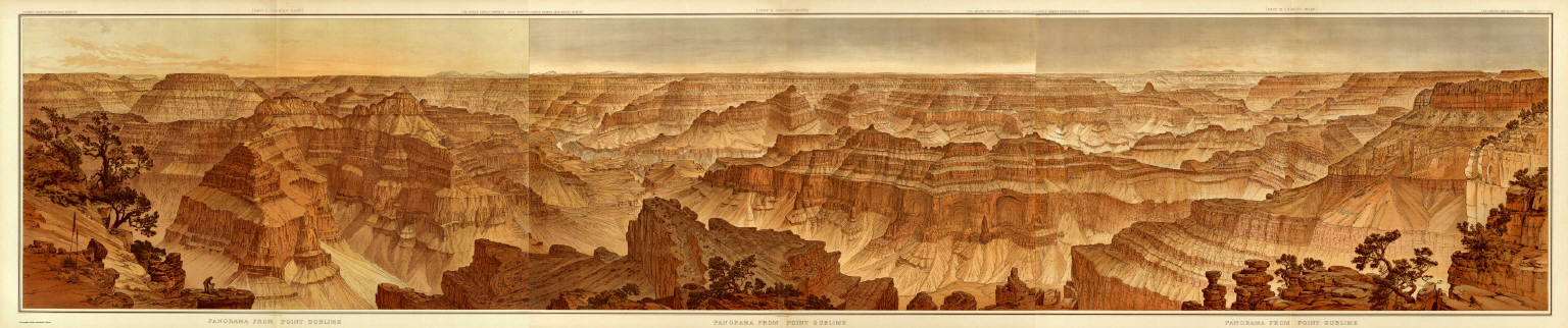
[Dutton, Clarence E. (Clarence Edward), 1841-1912, Holmes, William Henry, 1846-1933]
Full Title
(Composite) Panorama From Point Sublime. [Parts I-III.] W.H. Holmes. Atlas Sheets XV-XVII. Julius Bien & Co. lith. U.S. Geological Survey, Geology of the Grand Canon District.
List No
4713.019
Note
In full color. Composite of all sections using Atlas Sheets 15-17.
Author
Tanner, Henry S.
Full Title
(Composite of) A Map of North America, Constructed According To The Latest Information: by H.S. Tanner. S.E. Sheet. Entered ... 27th day of May 1822, by H.S. Tanner ... Pennsylvania. Engraved & Published by H.S. Tanner. Philadelphia. 1822. Printed by Wm. Duffee. American Atlas.
List No
5388.013
Note
Composite of the four North American map sheet. Scale measured at 10 degrees latitude. In full color.
Author
Paul, Rene
Full Title
Map Of The City Of St. Louis Compiled from information in the possession of Rene Paul Esqr. 1844. Published By Twichel & Cook N.W. Cor. Main & Pine Sts. St. Louis Mo. Engraved at the Office of J.T. Hammond, By T. Twichel. N.W. Cor. Main & Pine Streets. St. Louis Mo.
List No
4197.001
Note
Second edition. In covers with printed paper label "Map of the City of St. Louis, 1844." Engraved map, with three vignettes, two of buildings and one of a steamboat on the Mississippi River. Table of population statistics and a key to the important buildings located on the map. Color coded by ward. A beautiful map, exquisitely colored, and scarce. Rene Paul, the city surveyor, first issued this map in 1842. In 1835 Paul did a larger map of St. Louis separately and for Eugene Charles Dupre's Atlas of the City and County of St. Louis (illustrated in Ristow p.296, Karrow 9-1553-4). This earlier map was lithographed by Lehman & Duval. Folded into dark brown cloth covers 13x8 with "Map Of The City Of St. Louis, 1844" printed in black on yellow paste down label.
Author
Alaska Steamship Company
Full Title
Territory of Alaska. The Alaska Line. The All-American Route, Alaska Steamship Company, Serving All of Alaska. Copyright 1936, Frank McCaffrey, Seattle. Printed in U.S.A. (with two inset maps)
List No
5300.000
Note
Map is in full printed color. Inset maps: 1) Untitled map of the area around Anchorage and the Gulf of Alaska. 2) Untitled map of North America showing the routes from the "lower 48" to Alaska. A table of distances is included showing the mileage from Seattle to places in Alaska. The border is bright and original with totem poles. Mt. McKinley National Park is highlighted in green.
Author
Anderson, O.P. and Co.
Full Title
Anderson's New Guide Map Of The City Of Seattle And Environs, Washington. Compiled From Latest Official Records By O.P. Anderson And Co. Engineers and Draughtsmen. July, 1890. L.H. Everts, Phila. Pa. Prepared For Eshelman, Llewellyn & Co. Investment Brokers, Seattle, Washington. Entered ... 1890, by O.P. Anderson & Co. ... Washington, D.C. (untitled inset of the Seattle vicinity).
List No
4653.000
Note
This is somewhat later in the year than the "Whitney" version of this map (see our #4336) and show more property developments and more coverage on the east side of town. The smaller scale inset map of western Washington state is eliminated. Map in color by area.
Author
Arbuckle Bros.
Full Title
Colorado, Utah, Montana, Minnesota. Copyright 1889 Arbuckle Bros. N.Y.
List No
0027.007
Note
Sheet with maps of four states in full color. The Colorado plains are known as a "paradise for invalids" due to the mildness and purity of the atmosphere. Each card measures 7.5 x 12.5 cm.
Author
Blum, George W.
Full Title
Map of California Roads for Cyclers. This Map Engraved by the California Photo-Eng. Co. Wasp B'ld'g., 513 Market St., S.F. Designed & Drawn by Geo. W. Blum. Edward Denny & Co. 207 Montgomery St. Sole Agents. Published and Copyrighted by Geo. W. Blum, San Francisco, Cal. (with) Inset map of the Los Angeles area.
List No
1592.008
Note
Full color map surrounded by advertisements. Bike paths shown in red and labeled with abbreviations. The first abbreviation of the two tells the road condition. Conditions are: G (good), F (fair), P (poor), and V.P. (very poor). The second abbreviation is for the grade of the road. Grades include: L (level), R (rolling), H (hilly), and M (mountainous).
Author
Burritt, Elijah H.
Full Title
(The constellations in) September, August, July (Pl. V), June, May, April (Pl. IV). Engraved by W.G. Evans N. York, under the Direction of E.H. Burritt. Hartford, Published by F.J. Huntington 1835. Entered according to act of Congress Septr. 1st 1835, by F.J. Huntington, of the State of Connecticut.
List No
2853.003
Note
The pages are numbered in such a way that Plate V precedes Plate IV. The constellations are in full color. The stars are different sized depending upon their magnitude. In full color.
Author
Colton, G.W.
Full Title
(Half Title Page to) Colton's Atlas Of The World, Illustrating Physical And Political Geography. By George W. Colton. Accompanied By Descriptions Geographical, Statistical, And Historical, By Richard Swainson Fisher, M.D. Complete In One Volume. New York: J.H. Colton And Company, No. 172 William, Corner Beekman Street. London: Trubner And Company, No. 12 Paternoster Row. 1856. Entered ... One Thousand Eight Hundred and Fifty-five, by J.H. Colton And Company ... New York.
List No
0149B
Note
This large one volume 1856 edition is scarcer than the two volume edition. Initially, Colton's atlas was published by subscription (see our subscribers salesman's book) and in parts, then in a two volume edition with the first volume (North and South America) issued in 1855 and the second volume (Europe, Asia, etc.)in 1856. This atlas was the first world atlas produced by Colton, after many years of issuing pocket maps, wall maps, guides, and maps for books. The atlas was one of the finest and most accurate of the period - it had a long publishing run, continuing for over thirty years (with the title changed to Colton's General Atlas after 1856). In this issue, the Texas map is single page, 2nd state. New Mexico and Utah 2nd state. Bound into quarter leather embossed brown cloth covered boards with "Colton's Atlas Of The World" and an illustration stamped in gold. The same title is stamped on the spine. Full color maps.
Author
Colton, G.W.
Full Title
Map Of Boston And Adjacent Cities. Published by J.H. Colton & Co. 172 William St. New York. Entered ... 1855 by J.H. Colton & Co. ... New York. No. 13.
List No
0149.021
Note
In full color. Areas in the Boston Harbor and the Mill Dam are sketched in with roads and open space.
Author
Colton, J. H.
Full Title
Map Of The United States The British Provinces Mexico &c. Showing the Routes of the U.S. Mail Steam Packets to California, & A Plan of the Gold Region. Published By J.H. Colton, 86 Cedar St. New York. 1849. Drawn & Engraved by J.M. Atwood. New York. Entered ... 1849 by J.H. Colton ... New York. (inset) Map Of The Gold Region. California. (untitled inset of South America).
List No
0170.001
Note
With eleven pages of text titled "Particulars of Routes, Distances, Fares, &c., to Accompany Colton's Map of California and the Gold Region. Collected from Official Documents." On the map there is a view of Pyramid Lake over the title, taken from the Fremont Report and inset maps of the Gold Region and South America, showing the route around Cape Horn. Ackerman did the Lithography for this map as well as the Map of California, Oregon, and Texas (see our #98). This is the second state of the map - the first appeared in Fayette Robinson's "California and its Gold Regions" issued earlier in 1849 (see our 5029). Streeter: "This appears to be the first Colton map showing the gold fields." The North American portion of the map is taken from the North American map inset to the huge Smith/Colton "Map of the United States and the Canadas..." first issued in 1844; this inset later became the Johnson Family Atlas North American map of 1860. The map and the view of Pyramid Lake also appears in a Disturnell/Colton map of North America issued in 1854 and earlier (see our 3507). Outline color. Map is folded into dark blue cloth covers 13.5x8.5 with "Colton's Map Of The United States, Mexico &c. Shewing the Gold Region in California" printed in black on a tan paper label.
Author
Colton, J. H.
Full Title
Nebraska And Kansas. Published By J.H. Colton & Co. No. 172 William St. New York. Entered ... 1854 by J.H. Colton ... New York. (inset) Map Of The Territory acquired from Mexico by the Gadsden Treaty, 1854. (untitled inset of U.S., Mexico, Central America). Printed by D. Mc Lellan, 26 Spruce St. N.Y.
List No
3873.001
Note
First edition, first state. First map to show the new Kansas and Nebraska; also shows the important Gadsden Purchase of the same year. This state precedes all other copies we have seen - it is an early pull from the late 1854, early 1855 Colton Map of the United States of America... wall map plate (see our #2834, indicating it appeared in middle or late 1854 - see our 1855 wall map copy #2278 for the corrected topography), with the title different from the second 1854 state, in that the letters of Nebraska and Kansas have stars in them and are open as opposed to the black letters of the second state. Also, this first state has numerous areas that are "cleaned up" in the second state: the trail that crosses the two forks of the Colorado in southern Utah near the map edge has the word "Route" on it - this is removed in the second state; the vine border is reversed from the first to the second state; Louisiana is written straight across in the first - it curves down in the second; Bucksport and San Augustine are shown in Texas along the map southern edge in the second state and not in the first; Sacket's Well and Laguna in California in the inset map are given dots for their location in the second state but not in the first. There are other changes. Streeter shows a second edition in 1855, Heaston a third edition in 1856, but both copyrighted 1855. These have various route changes and place names added when compared to the 1854. A fourth edition appeared in 1857 (see Karrow 12-0361.2 and Graff 836) with the inset of the U.S. changed to Eastern Nebraska and Kansas. Map is full color by state, folded into red cloth covers 15x9 with "Nebraska And Kansas" stamped in gilt, advertisement for Colton on inside front cover.
Author
[Colton, J. H., Creuzbaur, Robert, De Cordova, Jacob]
Full Title
J. De Cordova's Map Of The State Of Texas Compiled from the records of the General Land Office of the State by Robert Creuzbaur, Revised and Corrected by Charles W. Pressler. Published by J.H. Colton & Co. No. 172 William St. New York 1856. Engraved by J.M. Atwood, New York. Entered ... 1856 by J. De Cordova ... Texas. (with untitled inset of southwestern U.S.).
List No
3366.001
Note
First edition of Pressler's revision of De Cordova's map, and first edition published by Colton. Shows Texas east of the 102nd meridian. First issued by De Cordova in 1849, with editions of 1850, 51, 53, 56, 57, 58, and 61 (Ristow and Rosenberg), and a late unlisted edition in 1867 (see our #4801). De Cordova employed Pressler to revise the map in 1855 and then sold the rights to Colton in the same year. The 1849 edition has only two copies located. Eberstadt called the 1849 issue "possibly the finest (Texas map) of the period." Colton changed the inset map from the oval showing all of Texas to the southwestern portion of Colton's U.S. atlas map. J.M. Atwood was the engraver of all editions. With a list of the Land districts, this map was useful for both land promoters and settlers. Colton published a reduced version of the map in his 1856 Atlas of the World. The full color map is folded into stamped dark maroon leather covers 16x10.5 with "J. De Cordova's Texas J.H. Colton & Co. New York." in gilt.
Author
Humboldt, Alexander von, 1769-1859
Full Title
(Composite Map of) Carte Generale Du Royaume De La Nouvelle Espagne depuis le Parallele de 16¼ jusqu'au Parallele de 38¼ (Latitude Nord). Dressee Sur des Observations Astronomiques et sur l'ensemble des Materiaux qui existoient a Mexico, au commencement de l'annee 1804. Par Alexandre de Humboldt. Ls. Aubert pere Scripsit. 1. and 1(bis). Dessine a Mexico par l'Auteur en 1804, perfectionne par le meme, par M.M. Friesen, Oltmanns, et Thuilier 1809. Grave par Barriere - et l'Ecriture par L. Aubert pere, a Paris.
List No
0328.003
Note
Composite map of Mexico. Without color.
Author
King, Clarence
Full Title
Nevada Basin. Map V. (Geological)
List No
0408.006
Note
Map in full color with the legends on either side of the maps. Map extends from Argenta, Nevada to the west of Pyramid Lake (Lake Tahoe) in California. Below the map are two geologic cross sections.
Author
Mitchell, Samuel Augustus
Full Title
Heights Of The Principal Mountains In The World. Lengths Of The Principal Rivers In The World. F. Humphrys. Sculpt. Entered ... 1846, H.N. Burroughs ... Pennsylvania.
List No
0537.001
Note
In full color with charts listing mountain heights and river lengths.
Author
[Colton, J. H., Norman, B.M., Persac, A.]
Full Title
Norman's Chart Of The Lower Mississippi River By A. Persac. Published by B.M. Norman, New Orleans, La. 1858. Entered ... 1858 by B.M. Norman ... Louisiana. Engraved, Printed & Mounted By J.H. Colton & Co. New York. (At top) From Natchez to New Orleans.
List No
2752.000
Note
Views; shows Plantations by type; very scarce. In full color; lacks original covers. See our reproduction copy issued by Pelican Press, originally in 1931, and printed by Rand McNally - this reproduction greatly alters the original. Ritzlin catalogue: "Persac was a well known surveyor and landscape painter... the map is quite scarce and normally in poor condition because most copies were used by river pilots to locate plantation landings. Few copies are known in contemporary boards. NUC lists only three copies ... however several copies are located in the south, including one which the Louisiana Supreme Court still uses in land ownership cases." Incredible detail, showing the Plantations on both sides of the river. Four engraved views. Engraved by J.H. Colton. Lacking boards, this copy has some tears at the folds with slight loss at some intersections, some light browning in two areas, but is overall a very good copy. Copies at LSU, Historic New Orleans Collection (504-523-4662). See Antiques Magazine, Nov. 1991 for Persac Article. Norman also published "Norman's New Orleans and Environs" with a map of the city, in 1845 (see our copy).
Author
[Bancroft & Thayer, Hancock, Henry, Hansen, George, Ord, E.O.C.]
Full Title
Map Of The City Of Los Angeles Showing the Confirmed Limits Surveyed in August 1857 by Henry Hancock U.S. Dep. Sury. Plan de la Ciudad De Los Angeles. Surveyed by E.O.C. Ord, Lt. U.S.A. and Wm. R. Hutton, Assistant, August 29, 1849. Donation Lots Surveyed by H. Hancock in August and April 1853, Geo. Hanson, Asst. Published By Bancroft & Thayer, Real Estate Brokers 21 Spring St. And W.H.J. Brooks Searcher Of Records Los Angeles, Cal. A.L. Bancroft & Co. Lith.
List No
5183.000
Note
This is a composite wall map incorporating the famous 1849 Ord Survey (Robinson's first Los Angeles map) and the Hancock and Hansen survey maps of 1853 and 1859. This is the first appearance of the manuscript Ord Survey as a printed map and is therefore of considerable importance. Bancroft and Thayer were real estate brokers active in the 1870's; Robinson dates the map as circa 1875 (the map is undated) based on their activities and the fact that the map "was a popular wall decoration for real estates offices in the 1870's and '80's." The Ord Survey is in the middle of the map with the Hancock and Hansen surveys surrounding it. The Ord Survey shows the original pueblo buildings, the farms around them, a small group of lots, water courses and hills. In contrast, the later Hancock and Hansen Surveys divide the lands outside the original town center into much larger rectangular lots of equal size, imposing a grid pattern on the earlier meandering lots that is both visually striking and a portent of the phenomenal growth of settlement to come. Separately, we acquired the covers for the pocket map version (without the pocket map) in which someone wrote in a contemporary hand "This cover contained the copy of the 1st map of the City of Los Angeles made in 1849 by Lt. Ord and is now framed and hanging in my office. I paid $5.00 for it." Covers are dark brown cloth 16x11 with "Published By Bancroft & Thayer, Real Estate Brokers, 21 Spring Street, And W.H.J. Brooks, Searcher of Records, Los Angeles, Cal." stamped in gilt.
Author
[Sidney, J.C., Smith, Robert P.]
Full Title
Sidney's Map of Ten Miles round. Map Of The Circuit Ten Miles Around The City Of Philadelphia With the names of Villages, Roads, Mills, Property Owners, Taverns, &c From Original Surveys by J.C. Sidney, C.E. ... Delaware Co. by Dr. Ash. Robert P. Smith, Publisher 144, Chestnut Street, Philadelphia 1847. Entered ... 1847 by Robert P. Smith ... Pennsylva. Drawn by J.C. Sidney. Prd. at P.S. Duval's Establmnt.
List No
4688.001
Note
Smith considered this to be "the most successful of our maps" and it is indeed a beautiful map and a fine example of early lithography printed by P.S. Duval. Although copyrighted by Robert Pearsal Smith, Ristow states that this map was considered by Smith father, John Jay Smith, to be his own work. There is a view of Girard College and another of Laurel Hill Cemetery in the lower corners of the map engraved by A. Kollner, one of Philadelphia earliest lithographic artists. This copy is from the Kollner collection of Nicholas Biddle Wainwright, who wrote the standard book on Philadelphia lithography and also the authoritative book on Kollner. Map is folded into burgundy leather covers 14x8.5 with "Sidney's Map Of Ten Miles Around Philadelphia" in gilt.
Author
United States Coast Survey
Full Title
Map of New-York Bay And Harbor And The Environs. Founded upon a Trigonometrical Survey under the direction of F.R. Hassler Superintendent of the Survey Of The Coast Of The United States. Triangulation by James Ferguson and Edmund Blunt Assistants. The Hydrology ... Thomas R. Gedney ... Topography by C. Renard and T.A. Jenkins ... Published in 1844. Presented to The University of Vermont ... A.D. Bache Superintendent, Coast Survey.
List No
2491.000
Note
6 sheets; first engraved chart issued by the U.S. Coast Survey. Without color. Hassler's "Magnum Opus" was not completed until a year after his death. This huge chart is the first major production of the survey, begun by Hassler in response to critic's charges that he was not producing usable charts for navigators, and finished by Bache. A smaller single sheet version was issued in 1845.
Author
Finley, Anthony
Full Title
Map of the States Of Ohio Indiana & Illinois And Part Of Michigan Territory Compiled from the Latest Authorities. D.H. Vance Del. J.H. Young Sc. Philada. Published by A. Finley 1825.
List No
0278.011
Note
In full color by county or region of the state. Statistical information includes mileage, population broken down by White Males, White Females, Free People of Colour, Slaves and Militia.
Author
Johnson, A.J.
Full Title
A Diagram Exhibiting the difference of time between the places shown & Washington. Ex. the figures on the Dials denote the Air-line distances from Washington. By Johnson & Browning. No. 84.
List No
2905.056
Note
Dials in color and in five rings around the center dial showing Washington at 12:00.
Author
Bowen, Emanuel
Full Title
A new & accurate map of the North Pole, with all the countries hitherto discovered situated near or adjacent to it, as well as some others more remote. Drawn from the latest and best authorities and regulated by astronoml. observatns. By Eman. Bowen. (London: Printed for William Innys, Richard Ware, Aaron Ward, J. and P. Knapton, John Clarke, T. Longman and T. Shewell, Thomas Osborne, Henry Whitridge ... M.DCC.XLVII)
List No
3733.069
Note
Engraved map. Includes geographic notes and ornamental cartouche. Relief shown pictorially.
Author
Jefferys, Thomas
Full Title
(Engraved title page to) The West-India atlas: or, a compendious description of the West-Indies: illustrated with forty one correct charts and maps, taken From actual surveys. Together with an historical account of the several countries and islands which compose that part of the world. By the late Thomas Jefferys, Geographer to the King. London: Printed for Robert Sayer and John Bennett, Map, Chart, Print-Sellers, and Globe Makers, Fleet-Street, M,DCC,LXXXIII.
List No
4723B
Note
This is a superb atlas of the West Indies and a companion atlas to Jeffery's American Atlas also first issued in 1775. The latest date on the charts in this copy is 1788 (The Cape Verd Islands). There is a beautifully illustrated title page that precedes the main title page, which reads "The West Indian Atlas..." Jefferys died in 1771; Sayer and Bennet acquired his materials in preparation for this atlas, and published the atlas posthumously under his name (as they did with the American Atlas) in 1775. The heart of this atlas and the most detailed part is the sixteen sheet large chart and index sheet of the whole of the West Indies. The rest of the atlas consists of charts of the Atlantic Islands and the British Channel, as well as individual maps and charts of seventeen islands in the West Indies. Twenty seven pages of text gives the sources for the maps and charts, and a historical account of the West Indies. Three of the large chart maps also appeared in the American Atlas. Comparing the two Florida sheets in this atlas to the same sheets in the 1775 American Atlas, numerous changes to the coast lines and other features appear. That would indicate that Sayer updated the charts as the atlas was reissued - Phillips shows issues of 1775, 1781, 1787, 1794, 1796, 1807, and 1818. With the 1794 and later editions, 20 maps are added of various additional islands. Sayer and Bennet also published in 1775 a smaller version of this atlas called "The West India Islands: From Actual Survey and Observations..." that consisted of the same text, a general chart of the Islands, and the same sixteen or seventeen (depending on the edition) charts of the islands that appear in the larger version (P3942). Finally, Jefferys himself published in 1762 "A Description of the Spanish Islands and Settlements on the Coast of the West Indies" which was issued in quarto, with a general chart and 32 maps and plans of harbors and towns (P3941).
Author
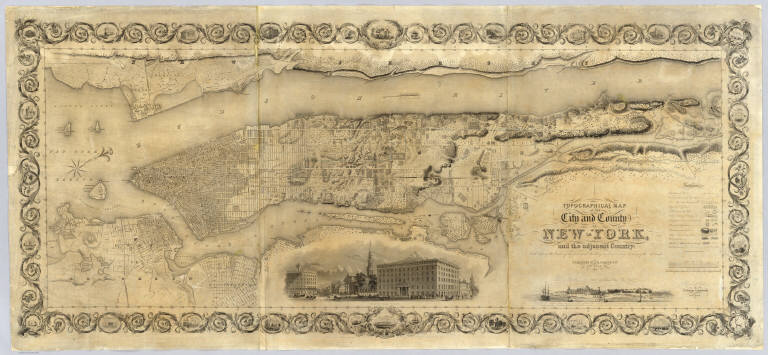
Colton, J. H.
Full Title
Topographical Map Of The City and County Of New - York, and the adjacent Country: With Views in the border of the principal Buildings and interesting Scenery of the Island. Published By J.H. Colton & Co. No. 4 Spruce St. New-York. 1836. Engraved & Printed by S. Stiles & Company, New-York. Entered ... 1836, by J.H. Colton & Co. ... New York.
List No
2784.000
Note
1st ed., 2nd state. Stokes: "This is one of the most beautiful nineteenth century plans or maps of Manhattan Island, and is full of interesting information, It is perhaps the last example of really artistic map-making, as applied to Manhattan Island." Ristow believes that Burr may have drawn this map based on similarities between it and the Burr New York City map that appeared in Burr's New York State Atlas of 1829. Accompanied by the "Summary History.." Stokes describes his copy of the 1st edition as not listing Madison Square and some other differences between the 1836 and 1841 editions which would lead one to conclude that this copy is slightly later than 1836 (it shows Madison Square which was established in 1837) - apparently an unrecorded 2nd state of the first edition. Without color or top and bottom rollers.
Author
[Beasley, T.D., Taylor, Jas. T.]
Full Title
Oahu, Hawaiian Islands. Compiled from Maps of Government Surveys and other reliable sources. Drawn by T.D. Beasley under supervision of Jas. T. Taylor, M. Am. Soc. C.E. November, 1899. United States, Copyright by Jas. T. Taylor 1899. Lith. Britton & Rey, S.F., Cal.
List No
3707.000
Note
Detailed, large scale map of Oahu made the year of annexation by the U.S. Shows lots and plantation names, topography, and town layouts. In full color. Relief shown by hachures and spot heights. Printed on 2 sheets. David Rumsey Collection copy mounted as one sheet; belonged to Michael M. O'Shaughnessy (deduced from ms "Oahu, Hawaii" in his hand), the famous California engineer (see 1881 Oahu map - our 3706); imprint cropped off.
Author
Haasis & Lubrecht
Full Title
The American Union Railroad Map Of The United States, British Possessions, West Indies, Mexico, And Central America. 1871. Published by Haasis & Lubrecht, 107 Liberty Street, New York. Smith & McDougal, Electrotypers, 82 Beekman Street, New York. (inset) Central America.
List No
3822.000
Note
This is a reworking of the Lubrecht and Rosa map "The American Continent" of 1864, and the first edition, first issue in a new format. Statistics at the top of the 1864 map are here replaced with a view "From the Atlantic to the Pacific Ocean" emphasizing the recently completed transcontinental railroad. Also, an elaborate title and view of a steam engine and train station have replaced the more subdued 1864 title. Population tables of the United States are added to the left and right sides of the map. The map itself has been updated to show political and some topographical changes of the ensuing seven years. Projected railroad lines are shown running everywhere in the west. The coloring is very bright, to match the decidedly optimistic (expansionist) flavor of the map. D.L. Guernsey published editions of 1871 and 1874 in Concord New Hampshire, with no major changes in the map. WH has an 1873 edition by Haasis and Lubrecht that adds text next to the population figures, more railroads, no changes in topography. Issued in a cover with a label in German from Wilhelm Lubrecht in Stuttgart, Germany, indicating it may have been sold to emigrants. Full color. Map has green paper edging, is dissected into 16 sections, and fold into a new gray cloth folding case 35x27 with "American Union Railroad Map Haasis & Lubrecht 1871" stamped in gilt on the spine.
Author
[California. Office of State Engineer, Hall, Wm. Ham. (William Hammond)]
Full Title
Los Angeles & San Bernardino topography. Wm. H. Hall, State Engineer, Sacramento. (circa 1880)
List No
3451.000
Note
Beautiful hand drawn map of the Los Angles-San Bernardino Basin. Pen-and-ink and pencil. Relief shown by hachures. It appears to be a base map on a scale of two miles to an inch, probably preliminary (several of Hall's notations on the edges indicate corrections needed to the topography) and earlier than the 1888 Report titled "Irrigation in California" that had 15 maps that may have been derived from this map. It may also have served as the base for "Drainage area map to accompany report on irrigation and water supply in California" by Wm. Ham. Hall, State Engineer. (188-?). Hall was a famous engineer who was the first state engineer and was responsible for many of the early state water projects (see California Water Atlas). This map does not have any names drawn in except for a few towns, rivers, or railroads lightly penciled in. All the land divisions and city plats are indicated, with mountains, rivers, railroads, roads, arroyos and shorelines shown. Hall also published four maps of the San Joaquin Valley in 1886 (see WH's copy) separately (see Calfornia Water Atlas p.26). "VI." Title and cartographer from verso. "14" on verso.
Author
Hayes, Eli L.
Full Title
Glass works of J.H. Hobbs, Brockunier & Co. ... Wheeling, West, Va. (... compiled & drawn for the publishers by E.L. Hayes, assisted by E.F. Hayes, C.M. Beresford, assisted by S.A. Charpiot, F.L. Sanford, J.H. Sherman. Published by Titus, Simmons & Titus ... Phila. 1877 ... Printed by H.J. Toudy & Co. ... Oldach & Mergenthaler Binders ...)
List No
4975.086
Note
Lithograph. External and internal views.
Author
Dunn, Samuel
Full Title
(Composite of) A general map of the world or terraqueous globe; with all the new discoveries and marginal delineations, containing the most interesting particulars in the solar, starry and mundane systems. By Saml. Dunn, Mathematician. London: printed for Rt. Sayer, Map, Chart and Printseller, 53 Fleet Street, 1787.
List No
0411.003
Note
Engraved map on 4 sheets. Continent boundaries in outline color. Shows explorers' tracks. Relief shown pictorially. Includes ancillary maps, charts and drawings of the solar system, the northern and southern hemispheres of the celestial globe, "An astronimical latitude & longitude analemma," "A chart of the world according to Mercator's projection with the Rhumb lines," "Selenography or a map of the Moon according to Father Riccioli," "The vicissitude of seasons explained," "The Analemma," two drawings entitled "The art of dialing by a common globe," "A Universal scale," and text. David Rumsey Collection copy has the 4 sheets mounted as 2. Small portion at top cropped off. (W 180--E 180/N 90--S 90)
Author
[Robert de Vaugondy, Didier, 1723-1786, Robert de Vaugondy, Gilles, 1688-1766]
Full Title
Mappemonde ou description du globe terrestre; dressee sur les memoires les plus nouveaux, et assujettie aux observations astronomiques, Par le Sr. Robert de Vaugondy, fils. A Paris, Chez Les Srs. Robert Geoges. ordes. du Roy, Quay de l'Horloge du Palais, Ante. Boudet Libraire-Imprimr. du Roy, rue St. Jacques. Avec Privilege 1752. C. Cochin filius delin. P.F. Tardieu sculp.
List No
3353.013
Note
Engraved double hemisphere map. Hand col. borders. Relief shown pictorially. Shows routes of Anson, l'Aigle de la Marie, Galion Na. Seignora. Ornamental cartouches.
Author
[Gray, R., Wilkinson, Robert]
Full Title
North America from the most authentic and latest surveys. R. Gray Sculpt. Glasgow, 1811.
List No
1204.000
Note
This is a copy of the 1804 Wilkinson North America map, here printed on linen. Very Scarce. Wilkinson's map of 1804 has been somewhat simplified to allow for limited detail due to printing on fabric. See our #5156 for the Wilkinson 1804 map (see also our copy of the 1826 reissue of Wilkinson's map which appears to be unchanged from the 1804 issue). With a decorative border of vines and tiny vignettes. John Faupel suggested this was probably made as a "commemorative" piece in a very small issue.
Author
Garnier, F. A., 1803-1863
Full Title
Amerique du Nord spheroidale. Atlas spheroidal & universel de geographie dresse par F.A. Garnier, geographe. Paris, Ve. Jules Renouard, Editeur, Rue de Tournon, no. 6, Fg. St. Gin. 1860. Imp. Sarazin, r. Git-le-Coeur, 8.
List No
5023.018
Note
Full col. Relief shown hachures. Prime meridian: Paris. On globe in cartouche: Sphericite de la terre.
Author
[Andreas, A. T. (Alfred Theodore), 1839-1900, Ellsbury, Geo. H.]
Full Title
Minneapolis, Minn. Hoffman (lithographer). Chas. Shober & Co., Proprietors of Chicago Lith. Co. Entered, according to act of Congress, year A.D. 1874, by Geo. H. Ellsbury and V. Green ... (Published by A.T. Andreas, Lakeside Building, Chicago)
List No
3034.024
Note
Col. lithograph. Panoramic view.
1-62 of 62
|