Author
[Martin, R.M., Tallis, J. & F.]
Full Title
Germany. The Illustrations by N. Whittock & Engraved by J. Rogers. The Map Drawn & Engraved by J. Rapkin.
List No
0466.020
Note
In outline color by region with numerous drawings of cities, houses, and "The Inventors of Printing: Guttemberg, Faust, Schoffeer." Decorative border with Germany seals and musical instruments.
Author
Berghaus, Heinrich
Full Title
(Covers to Vol. 2) Dr. Heinrich Berghaus' Physikalischer Atlas oder Sammlung von Karten, auf denen die hauptsachlichsten Erscheinungen der anorganischen und organischen Natur nach ihrer geographischen Verbreitung und Vertheilung bildlich dargestellt sind ... 1845. Verlag von Justus Perthes in Gotha ... 1848 ...
List No
2515G
Author
Berghaus, Heinrich
Full Title
(Title Page to Vol. 2) Dr. Heinrich Berghaus' Physikalischer Atlas oder Sammlung von Karten, auf denen die hauptsachlichsten Erscheinungen der anorganischen und organischen Natur nach ihrer geographischen Verbreitung und Vertheilung bildlich dargestellt sind ... 1845. Verlag von Justus Perthes in Gotha ... 1848 ...
List No
2515H
Note
Of the 90 plates, 75 are maps. 1st ed 2nd state,1845/1848 on titles, 1849 on some maps in volume one. 1st edition, 1st state was 1845/1848, with no maps dated later than 1848 (rare - WH). Second edition 1852 (see our copy). This is considered the first comprehensive physical atlas of the world. Robinson: "Berghaus' Physikalischer Atlas was a monumental achievement, bringing together an enormous amount of information about the physical geography of the earth and encompassing many more subjects than had been treated in the numerous smaller atlases that had been produced since the 1820's." In two volumes, the first dated 1845, the second 1848. A.K. Johnston's Physical Atlas of 1848 was based on this work. Maps are hand painted in full and outline color. Atlas volumes are bound in green cloth covered boards stamped in gold with "Berghaus' Physik. Atlas 90 Karten. I Band." and "... II Band." for volumes I and II, respectively. The spines read "Berghaus. I." and "Berghaus. II."
Author
Berghaus, Heinrich
Full Title
Deutschland, Niederlande, Belgien und Schweiz: National, Sprach, Dialect Verschiedenheit. Entnorfen im April 1847. 8te Abtheilung: Ethnographie No 9. Gestochen v. C. Poppey. Gotha: J. Perthes. 1848.
List No
2515.072
Note
Map showing the diversity of speech and dialect throughout Germany, the Netherlands, Begium and Switzerland. In partial color.
Author
Bowen, Emanuel
Full Title
A new & accurate map of the South West part of Germany. Comprehending the Archbishopricks of Mentz and Treves; the Electoral Palat: of the Rhine; Duchy of Wirtemberg; Franconia, Swabia, Alsace, Lorrain &c. Drawn from the best authorities and most approved maps and regulated by astronl. observations. By Emanl. Bowen. (London: Printed for William Innys, Richard Ware, Aaron Ward, J. and P. Knapton, John Clarke, T. Longman and T. Shewell, Thomas Osborne, Henry Whitridge ... M.DCC.XLVII)
List No
3733.015
Note
Engraved map. Covers also Luxembourg. Shows forested areas. Relief shown pictorially. Includes cartographic note and ornamental cartouche. Includes 2 inset maps entitled, "Exact plans of old and new Brisac or Brisach with their fortifications and places adjacent."
Author
Bowen, Emanuel
Full Title
(Title Page to) A complete system of geography. Being a description of all the countries, islands, cities, chief towns, harbours, lakes, and rivers, mountains, mines, &c. of the known world ... In two volumes. The whole illustrated with seventy maps, by Emanuel Bowen, Geographer to His Majesty, being all new-drawn and ingraved according to the latest discoveries and surveys; making, of themselves, a complete atlas, for the sse of gentlemen, merchants, mariners, and others, who delight in history and geography ... Vol. 1. London: Printed for William Innys, Richard Ware, Aaron Ward, J. and P. Knapton, John Clarke, T. Longman and T. Shewell, Thomas Osborne, Henry Whitridge ... M.DCC.XLVII.
List No
3733A
Note
In the title Bowen states that he is "Preserving all that is useful in the Fourth and Last edition of the Complete Geographer, publish'd under the name of Herman Moll, &c." The 70 maps were also published in two other forms: in "A Complete Atlas" of 1752, and as the Maps for the "Complete Collection of Voyages" by John Harris, in 1744-48 (M&B). The text is massive and interesting, and there are several important maps of America: America, West Indies, Mexico, Louisiana, Carolina, Virginia, Pennsylvania et al, and Newfoundland et al. The map of the World in Hemispheres is lacking in this copy. Both volumes are newly bound in full brown leather covered boards with "Geography. Vol. 1" and -Geography. Vol. 2" embossed on the spine in gilt.
Author
L'Isle, Guillaume de, 1675-1726
Full Title
Le Cours du Rhin au dessus de Strasbourg, et les Pais adjacens. Par Guill. de l'Isle, de l'Academ. Rle. des Sciences. A Paris, chez l'Auteur sur le Quai de l'Horloge a l'Aigle d'Or, 1704, avec Privilege. Grave par Liebaux le fils.
List No
4764.044
Note
Engraved map in outline color. Urban areas in color. Shows forests, etc. Covers portions of Alsace and Brisgaw from Strasbourg to Lake Constance. Relief shown pictorially.
Author
L'Isle, Guillaume de, 1675-1726
Full Title
Le Cours du Rhin depuis Strasbourg, jusqu'a Worms et le pays adjacens. Par Guill. Del'Isle, Geogr. de l'Academie Royale des Sciences. A Paris, chez l'Auteur sur le Quai de l'Horloge (1704)
List No
4764.045
Note
Engraved map in outline color. Urban areas in color. Shows forests, etc. Covers portions of Alsace and Rhineland Palatinate. Relief shown pictorially.
Author
L'Isle, Guillaume de, 1675-1726
Full Title
Le Cours du Rhin depuis Worms, jusqu'a Bonne, et le pays adjacens. Par Guill. Del'Isle, Geographe de l'Academie Royale des Sciences, avec Privilege du Roy pour 20. ans, 1704. A Paris, chez l'Auteur sur le Quai de l'Horloge.
List No
4764.046
Note
Engraved map in outline color. Urban areas in color. Shows forests, etc. Relief shown pictorially.
Author
L'Isle, Guillaume de, 1675-1726
Full Title
(Composite of) Le Cours du Rhin ... et le pays adjacens. Par Guill. de l'Isle, de l'Academ. Rle. des Sciences. A Paris, chez l'Auteur sur le Quai de l'Horloge a l'Aigle d'Or, 1704, avec Privilege. Grave par Liebaux le fils.
List No
4764.047
Note
Engraved map in outline color. Urban areas in color. Shows forests, etc. Relief shown pictorially.
Author
[Bartholomew, J. G. (John George), 1860-1920, John Bartholomew and Son]
Full Title
(Title Page to) Times survey atlas of the world. London: The Times, 1922.
List No
2113B
Note
This is the second issue of the 1920 edition, which was the first edition to use Bartholomew's maps (the only earlier edition used maps by Andree, published in 1895 (see our #1010). Superb maps, beginning a run of Times Atlas editions that continues today. Cover title: The Times atlas & gazetteer of the world. Includes page of corrections from the 1920 ed.
Author
[Bartholomew, J. G. (John George), 1860-1920, John Bartholomew and Son]
Full Title
Germany - southern section. The Edinburgh Geographical Institute, John Bartholomew & Son, Ltd. "The Times" atlas. (London: The Times, 1922)
List No
2113.043
Note
Col. map. Relief shown by hypsometric tints and spot heights.
Author
[Bartholomew, J. G. (John George), 1860-1920, John Bartholomew and Son]
Full Title
Germany - western section. (with Berlin Region). The Edinburgh Geographical Institute, John Bartholomew & Son, Ltd. "The Times" atlas. (London: The Times, 1922)
List No
2113.044
Note
Col. map. Relief shown by hypsometric tints and spot heights; depths by bathymetric tints. Inset at 1:150,000 scale.
Author
[Bartholomew, J. G. (John George), 1860-1920, John Bartholomew and Son]
Full Title
Germany - eastern section. The Edinburgh Geographical Institute, John Bartholomew & Son, Ltd. "The Times" atlas. (London: The Times, 1922)
List No
2113.045
Note
Col. map. Relief shown by hypsometric tints and spot heights; depths by bathymetric tints.
Author
[Bartholomew, J. G. (John George), 1860-1920, John Bartholomew and Son]
Full Title
(Composite of) Germany. The Edinburgh Geographical Institute, John Bartholomew & Son, Ltd. "The Times" atlas. (London: The Times, 1922)
List No
2113.046
Note
Composite of three col. maps. Relief shown by hypsometric tints and spot heights; depths by bathymetric tints. Includes inset.
Author
Fullarton, A. & Co.
Full Title
Southern Germany. XV. (with) Southern States of Germany comprising Bavaria, Wurtemburg, Baden, Nassau, Darmstadt, Coburg, &c. (with) five inset maps: Nuremberg, Munich, Mayence, State of Frankfort, and Frankfort. J. Bartholomew Sc. Edinr. A. Fullarton & Co. London, Edinburgh & Dublin.
List No
3007.015
Note
In full color. Each of the city maps has a legend referencing the letters shown.
Author
[Homann, Johann Baptist, 1663-1724, Hubner, Johann, 1688-1731]
Full Title
(Title Page to) Atlas methodicus explorandis juvenum profectibus in studio geographico ad methodum Hubnerianam accommodatus, a Johanne Baptista Homanno, Sacrae Caesareae Majestatis Geographo. Noribergae. Anno MDCCXIX. Methodischer Atlas das ist, Art und Weise, wie die Jugend in Erlernung der Geographie fuglich examiniret werden kan/ nach Hubnerischer Lehr-Urt eingerichtet von Johann Baptist Homann ... Nurnberg, U. 1719.
List No
4385B
Note
First (and only?) ed. One of the earliest school atlases to use a system of letters on blank maps that are coded to a separate key list. This method was based on a teaching system formulated by Johann Hubner (1668-1731) and adapted by Homann. Four celestial maps illustrate the systems of Ptolemy, Tycho Brahe, Copernicus, and Descartes. Fourteen keyed maps show the countries and continents of Europe, Asia, Africa and the Americas. California is shown as an island on the Americas map, and listed under islands in the key. Homann published an Atlas Scholasticus in 1732 (Phillips 577) which was also a collaboration with Hubner. Scarce. Maps are in full color, and atlas is bound in untitled red marbled paper covered boards with a vellum spine.
Author
[Homann, Johann Baptist, 1663-1724, Hubner, Johann, 1688-1731]
Full Title
(Text Page in] Atlas methodicus explorandis juvenum profectibus in studio geographico ad methodum Hubnerianam accommodatus, a Johanne Baptista Homanno, Sacrae Caesareae Majestatis Geographo. Noribergae. Anno MDCCXIX. Methodischer Atlas das ist, Art und Weise, wie die Jugend in Erlernung der Geographie fuglich examiniret werden kan/ nach Hubnerischer Lehr-Urt eingerichtet von Johann Baptist Homann ... Nurnberg, U. 1719.
List No
4385H
Note
Tenth and 11th pages of "Erklarung" of abbreviations used on maps.
Author
[Homann, Johann Baptist, 1663-1724, Hubner, Johann, 1688-1731]
Full Title
Atlas methodicus explorandis juvenum profectibus in studio geographico ad methodum Hubnerianam accommodatus, a Joh. Bapt. Homanno, Norimbergae. Systema Ptolomaicum, Systema Copernicanum, Systema Tychonicum, Systema Cartesianum. (Charte vom Globo. 1719)
List No
4385.001
Note
Engraved ornamental title page, 4 diagrams of the Solar System (map 2) and world map (map 3). The double-hemisphere world map shows California as an island and has circular polar insets. All hand col.
Author
[Homann, Johann Baptist, 1663-1724, Hubner, Johann, 1688-1731]
Full Title
(Charte von Teutschland. Charte von Pohlen. Charte von Ungarn und Turcken. Charte von Moscau oder Russland. Johanne Baptista Homanno, Norimbergae, 1719)
List No
4385.005
Note
Four hand col. engraved outline maps. Show provincial boundaries and major and cities and rivers. Numbered 16-19.
Author
Kitchin, Thomas
Full Title
(Title Page to) A general atlas, describing the whole universe: being a complete collection of the most approved maps extant; corrected with the greatest care, and augmented from the latest discoveries. The whole being an improvement of the maps of D'Anville and Robert. Engraved in the best manner on sixty-two copper-plates, by Thomas Kitchin, Senior, and Others. London: printed For Robert Sayer, no. 53, Fleet-Street, (1790).
List No
0411B
Note
Late issue. Many of the maps are double sheet. This atlas was later expanded to become the New Universal Atlas (see David Rumsey Collection copy). Some of these maps also appeared in the American Atlas by Jefferys. There are actually 23 large maps, on 35 connected sheets, produced from 62 copper plates. Maps are hand painted with outline and full color and bound in half leather tan marbled paper covered boards with "General Atlas" stamped in gold on the spine. Inscription inside front cover in pen-and-ink: R. Sayer pub, 53 Fleet ... 8th, 1791 ...
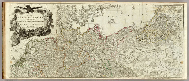
Author
Delarochette, Louis Stanislas d'Arcy
Full Title
Map of the Empire of Germany, including all the states comprehended under that name: with the Kingdom of Prussia, &c. (Northern section). By L. Delarochette. (T. Kitchin, sculpt.) London, printed for Robt. Sayer, Map & Print Seller, opposite Fetter Lane in Fleet Street, (1790?)
List No
0411.022
Note
Engraved map in outline color. Printed on 2 sheets with titles: The Circles of Westphalia, and Lower Saxony, with the western parts of the Circle of Upper Saxony, and the northern parts of the Circle of Upper Rhine, part of Sweden, and Denmark; the United Provinces, and part of the Netherlands -- Eastern parts of Brandenburg and Saxony, with Pomerania, Prussia, Lusatia, and the northern parts of Silesia; part of Sweden, Samogitia, Lithuania, and Poland. Shows vegetation, banks, etc. Relief shown pictorially. Prime meridian: Ferro. Ornamental title cartouche. David Rumsey Collection copy mounted as 1 sheet.
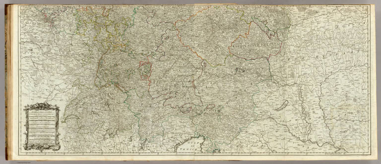
Author
Delarochette, Louis Stanislas d'Arcy
Full Title
(Map of the Empire of Germany, including all the states comprehended under that name: with the Kingdom of Prussia, &c. Southern section. By L. Delarochette). T. Kitchin, sculpt. (London, printed for Robt. Sayer, Map & Print Seller, opposite Fetter Lane in Fleet Street, 1790?)
List No
0411.023
Note
Engraved map in outline color. Printed on 2 sheets with titles: The Circles of Lower Rhine, Franconia, Swabia, Bavaria, with the southern parts of the Circles of ... -- Eastern parts of Bohemia, and of the Circle of Austria ... Shows vegetation, etc. Relief shown pictorially. Prime meridian: Ferro. Ornamental title cartouche. David Rumsey Collection copy mounted as 1 sheet; portions of sheet titles in upper margin missing.
Author
Delarochette, Louis Stanislas d'Arcy
Full Title
(Composite of) Map of the Empire of Germany, including all the states comprehended under that name: with the Kingdom of Prussia, &c. By L. Delarochette. T. Kitchin, sculpt. London, printed for Robt. Sayer, Map & Print Seller, opposite Fetter Lane in Fleet Street, (1790?)
List No
0411.024
Note
Engraved map in outline color. Printed on 4 sheets. Shows vegetation, banks, etc. Relief shown pictorially. Prime meridian: Ferro. Ornamental title cartouche. David Rumsey Collection copy mounted as 2 sheets; portions of sheet titles in upper margin of lower sheets missing.
Author
Robert de Vaugondy, Gilles, 1688-1766
Full Title
(Covers to) Atlas Universel, Par M. Robert Geographe ordinaire du Roy, et Par M. Robert De Vaugondy son fils Geographe ord. du Roy, et de S. M. Polonoise, Duc de Lorraine et de Bar, et Associe de L'Academie Royale des Sciences et belles Lettres de Nancy, Avec Privilege Du Roy, 1757. A Paris, Chez Les Auteurs ,Quay de l'Horloge du Palais, Boudet Libraire Imprimeur du Roi, rue St. Jacques. Grave par Ch. Baquoy. J. Oger Scripsit.
List No
3353A
Note
1st edition, with five postal maps added, as issued. With the list of subscribers and the extra postal maps of England, France, Germany, Italy and Spain. The French postal map is dated 1758. All five were added after the printed list of maps was printed, but are mentioned by Vaugondy in the preface, so they may have been an afterthought. An owner has added their titles to the printed list of maps, in ms. Engraved title page, Advertisement, and Geographical essay giving the sources of the maps. This atlas was reissued until 1799 (Phillips), with later issues having a map of the United States. In original half leather patterned paper covered boards with spine reading "Nouvel Atlas De Mrs. Robert." One of the first atlases based on scientific surveys, in the tradition of D'Anville and De L'Isle. Outline color.
Author
Robert de Vaugondy, Gilles, 1688-1766
Full Title
(Title Page to) Atlas Universel, Par M. Robert Geographe ordinaire du Roy, et Par M. Robert De Vaugondy son fils Geographe ord. du Roy, et de S. M. Polonoise, Duc de Lorraine et de Bar, et Associe de L'Academie Royale des Sciences et belles Lettres de Nancy, Avec Privilege Du Roy, 1757. A Paris, Chez Les Auteurs ,Quay de l'Horloge du Palais, Boudet Libraire Imprimeur du Roi, rue St. Jacques. Grave par Ch. Baquoy. J. Oger Scripsit.
List No
3353B
Note
1st edition, with five postal maps added, as issued. With the list of subscribers and the extra postal maps of England, France, Germany, Italy and Spain. The French postal map is dated 1758. All five were added after the printed list of maps was printed, but are mentioned by Vaugondy in the preface, so they may have been an afterthought. An owner has added their titles to the printed list of maps, in ms. Engraved title page, Advertisement, and Geographical essay giving the sources of the maps. This atlas was reissued until 1799 (Phillips), with later issues having a map of the United States. In original half leather patterned paper covered boards with spine reading "Nouvel Atlas De Mrs. Robert." One of the first atlases based on scientific surveys, in the tradition of D'Anville and De L'Isle. Outline color.
Author
[Robert de Vaugondy, Didier, 1723-1786, Robert de Vaugondy, Gilles, 1688-1766]
Full Title
Germania Antiqua in quatuor magnos populos, in minores et minimos distincta, et Regiones Danubium inter et mare Adriaticum contentae. Autore Robert de Vaugondy Geog. Regis ord? et regiae Scient? ac Litterarum Academiae Nanceiensis socio. Cum Privilegio 1756. E. Haussard, sculp.
List No
3353.007
Note
Engraved map. Hand col. borders. Relief shown pictorially. Ornamental cartouche.
Author
[Robert de Vaugondy, Didier, 1723-1786, Robert de Vaugondy, Gilles, 1688-1766]
Full Title
Carte des Cercles du Haut et du Bas Rhin ou se trouvent dans le premier, le Duche de Deux-Ponts, les Echeves de Worms, et de Spire, les Etats de Nassau et de Hesse, les Comtes de Hanaw, de Solms, d'Isenburg, les Abbeyes de Fulde et d'Hirchfeld &c., et dans le second, les Electorats de Mayence, de Treves, de Cologne, et le Palatinat du Rhin, avec leurs enclaves. Par le Sr. Robert de Vaugondy Geog? ord. du Roy 1753. Avec Privilege. (Elisabeth?) Hau(ssard, sculp.)
List No
3353.062
Note
Engraved map. Hand col. borders. Relief shown pictorially. Ornamental cartouche.
Author
Society for the Diffusion of Useful Knowledge (Great Britain)
Full Title
Germany. Deutschland III. Baden, Wurtemberg, Bavaria, Tyrol, and Switzerland. Eastern part of the Prussian States. Published under the superintendence of the Society for the Diffusion of Useful Knowledge. J. & C. Walker sculpt. London, published by Baldwin & Cradock, 47 Paternoster Row, June 1st. 1832. (London: Chapman & Hall, 1844)
List No
0890.053
Note
Engraved map. Relief shown by hachures and spot heights. Political division borders hand col. Sources: Raglovich, Keller and Fallon.
Author
[Bonne, Rigobert, 1727-1794, Lattre, Jean]
Full Title
(Title Page to) Atlas moderne ou collection de cartes sur toutes les parties du globe terrestre ar plusieurs auteurs. Avec approbation & privilege du Roy. A Paris, Chez Lattre Graveur Ordinaire du Roy, de Mgr. Le Duc d'Orleans et de la Ville Rue St. Jacques No. 20. et Delalain Libraire, rue de la Comedie Francoise, (1791) (title page only) Monnet del. 1762. Prevost Sculp.
List No
2612B
Note
Engraved decorative title page. Maps by Bonne, Janvier, & Rizzi Zannoni. Late edition which includes important maps of the United States, British America, and Mexico which do not appear in the earlier editions. Also has an excellent catalogue of Lattre's publications. The first edition of this atlas had 36 maps (see Baskes copy). Maps are with outline hand col. and bound in full brown leather covers embossed with "Atlas Moderne" on the spine.
Author
Rizzi Zannoni, Giovanni Antonio Bartolomeo, 1736-1814
Full Title
(Carte de l'Empire d'Alemagne avec les Etats de Boheme. 1ere feuille. Dressee d'apres la carte de l'Academie Royale de Berlin et d'apres plusieurs autres. Par Mr. Rizzi Zannoni de l'Acad. Rle. des Sc. et Belles Let. de Gottingue. A Paris, Chez Lattre, Rue St. Jacques a la Ville de Bordeaux. Avec priv. du Roi. 178-?) Dediee et presentee a S.E. Monseigneur J.D. Almoreau Tiepolo, Ambassadeur Ordinaire pour la Serenissime Republique de Venise a la Cour de France. Par son tres humble et tres obeissant serviteur J.A.B. Rizzi Zannoni.
List No
2612.032
Note
Engraved map. Sheet 1 (NW) of 4. Boundaries outlined in hand col. Ornamental cartouche. Prime meridian: Ferro.
Author
Rizzi Zannoni, Giovanni Antonio Bartolomeo, 1736-1814
Full Title
(Carte de l'Empire d'Alemagne avec les Etats de Boheme. 2eme feuille. Dressee d'apres la carte de l'Academie Royale de Berlin et d'apres plusieurs autres. Par Mr. Rizzi Zannoni de l'Acad. Rle. des Sc. et Belles Let. de Gottingue. A Paris, Chez Lattre, Rue St. Jacques a la Ville de Bordeaux. Avec priv. du Roi. 178-? Dediee et presentee a S.E. Monseigneur J.D. Almoreau Tiepolo, Ambassadeur Ordinaire pour la Serenissime Republique de Venise a la Cour de France. Par son tres humble et tres obeissant serviteur J.A.B. Rizzi Zannoni)
List No
2612.033
Note
Engraved map. Sheet 2 (NE) of 4. Boundaries outlined in hand col. Relief shown pictorially. Prime meridian: Ferro.
Author
Rizzi Zannoni, Giovanni Antonio Bartolomeo, 1736-1814
Full Title
Carte de l'Empire d'Alemagne avec les Etats de Boheme. (3eme feuille). Dressee d'apres la carte de l'Academie Royale de Berlin et d'apres plusieurs autres. Par Mr. Rizzi Zannoni de l'Acad. Rle. des Sc. et Belles Let. de Gottingue. A Paris, Chez Lattre, Rue St. Jacques a la Ville de Bordeaux. Avec priv. du Roi. (178-? Dediee et presentee a S.E. Monseigneur J.D. Almoreau Tiepolo, Ambassadeur Ordinaire pour la Serenissime Republique de Venise a la Cour de France. Par son tres humble et tres obeissant serviteur J.A.B. Rizzi Zannoni)
List No
2612.034
Note
Engraved map. Sheet 3 (SW) of 4. Boundaries outlined in hand col. Relief shown pictorially. Ornamental cartouche. Prime meridian: Ferro.
Author
Rizzi Zannoni, Giovanni Antonio Bartolomeo, 1736-1814
Full Title
(Carte de l'Empire d'Alemagne avec les Etats de Boheme. 4eme feuille. Dressee d'apres la carte de l'Academie Royale de Berlin et d'apres plusieurs autres. Par Mr. Rizzi Zannoni de l'Acad. Rle. des Sc. et Belles Let. de Gottingue. A Paris, Chez Lattre, Rue St. Jacques a la Ville de Bordeaux. Avec priv. du Roi. 178-? Dediee et presentee a S.E. Monseigneur J.D. Almoreau Tiepolo, Ambassadeur Ordinaire pour la Serenissime Republique de Venise a la Cour de France. Par son tres humble et tres obeissant serviteur J.A.B. Rizzi Zannoni)
List No
2612.035
Note
Engraved map. Sheet 4 (SE) of 4. Boundaries outlined in hand col. Relief shown pictorially. Prime meridian: Ferro.
Author
Rizzi Zannoni, Giovanni Antonio Bartolomeo, 1736-1814
Full Title
(Composite of) Carte de l'Empire d'Alemagne avec les Etats de Boheme. Dressee d'apres la carte de l'Academie Royale de Berlin et d'apres plusieurs autres. Par Mr. Rizzi Zannoni de l'Acad. Rle. des Sc. et Belles Let. de Gottingue. A Paris, Chez Lattre, Rue St. Jacques a la Ville de Bordeaux. Avec priv. du Roi. (178-?) Dediee et presentee a S.E. Monseigneur J.D. Almoreau Tiepolo, Ambassadeur Ordinaire pour la Serenissime Republique de Venise a la Cour de France. Par son tres humble et tres obeissant serviteur J.A.B. Rizzi Zannoni.
List No
2612.036
Note
Engraved map on 4 sheets. Boundaries outlined in hand col. Relief shown pictorially. Ornamental cartouches. Prime meridian: Ferro.
Author
Society for the Diffusion of Useful Knowledge (Great Britain)
Full Title
(Title Page to) Maps of the Society for the Diffusion of Useful Knowledge. Vol. 1. London: Chapman and Hall, 186, Strand, 1844.
List No
0890B
Note
The SDUK, as the Society was known, produced inexpensive maps to encourage broad use in education. The maps in these two volumes were issued in parts over several years. The city plans are of particular interest, with vignettes and great detail. The gnomonic star maps were issued separately in this edition in their own covers. This is the second edition, the first being by Baldwin and Cradock, with the maps issued in numbers and later bound as a set. Rumsey Collection copy originally issued without the 6 "World on a gnomonic projection" maps; copies of them have been laid in. Atlas is bound in half leather dark brown cloth covered boards with "Maps. Vol. 1," "Maps. Vol. 2" stamped in gold on the spines. Maps with outline color; geological map of England and Wales hand colored in full color.
Author
Society for the Diffusion of Useful Knowledge (Great Britain)
Full Title
Germany general map. Engraved by J. & C. Walker. Published by the Society for the Diffusion of Useful Knowledge, 59 Lincolns Inn Fields Augt. 1st, 1840. (London: Chapman & Hall, 1844)
List No
0890.050
Note
Engraved map. Relief shown by hachures. Country borders hand col. Covers Germany, Switzerland, and Austria-Hungary. Includes population table.
Author
Society for the Diffusion of Useful Knowledge (Great Britain)
Full Title
Berlin. Published under the superintendence of the Society for the Diffusion of Useful Knowledge. Drawn by W.B. Clarke, Archt. Engraved & printed by J. Henshall. Published by Baldwin & Cradock, 47 Paternoster Row, Augt. 1. 1833. (London: Chapman & Hall, 1844)
List No
0890.163
Note
Engraved map. Relief shown by hachures. Hand col. Includes drawings of the facades of 10 buildings.
Author
Society for the Diffusion of Useful Knowledge (Great Britain)
Full Title
Dresden. Published under the superintendence of the Society for the Diffusion of Useful Knowledge. Drawn by W.B. Clarke, Archt. Engraved by W. Henshall. Published by Baldwin & Cradock, 47 Paternoster Row, 1833. Printed by Henshall. (London: Chapman & Hall, 1844)
List No
0890.171
Note
Engraved map. Hand col. Includes drawings of 13 structures.
Author
Society for the Diffusion of Useful Knowledge (Great Britain)
Full Title
Frankfort. Frankfurt am Mayn. Published under the superintendence of the Society for the Diffusion of Useful Knowledge. Drawn by W.B. Clarke, Archt. Engraved by T.E. Nicholson. Printed by E. Brain. Published Baldwin & Cradock, 47 Paternoster Row, 1837. (London: Chapman & Hall, 1844)
List No
0890.177
Note
Engraved map. Hand col. Inset: View of Frankfort, from Sachsenhausen.
Author
Society for the Diffusion of Useful Knowledge (Great Britain)
Full Title
Hamburg. Engraved by B.R. Davies, 16 George Str., Euston Squ. London, published May 1841 by the Society for the Diffusion of Useful Knowledge, 59 Lincolns Inn Fields. (London: Chapman & Hall, 1844)
List No
0890.180
Note
Engraved map. Hand col.
Author
Society for the Diffusion of Useful Knowledge (Great Britain)
Full Title
Munich. Muenchen. Published under the superintendence of the Society for the Diffusion of Useful Knowledge. (Drawn by) W.B. Clarke, arch. Engd. by T. Bradley. Published by Baldwin & Cradock, 47 Paternoster Row, Decr. 1st. 1832. (London: Chapman & Hall, 1844)
List No
0890.190
Note
Engraved map. Hand col. Inset: View of Munich from the East.
Author
Johnston, Alexander Keith, 1804-1871
Full Title
South-western Germany by Keith Johnston, F.R.S.E. Engraved & printed by W. & A.K. Johnston, Edinburgh. William Blackwood & Sons, Edinburgh & London, (1861)
List No
0373.021
Note
Engraved map. Boundaries hand col.; hydrography printed in blue. Relief shown by hachures. "Keith Johnston's general atlas 18."
Author
Cary, John, ca. 1754-1835
Full Title
A new map of the circles of the Upper and Lower Rhine, from the latest authorities. By John Cary, engraver, 1799. London: Printed for J. Cary, Engraver & Map-seller, No. 181, Strand, Augst. 1st., 1799.
List No
1657.028
Note
Engraved map. Boundaries in outline hand col. "27" pasted on verso.
Author
Meyer, Joseph, 1796-1856
Full Title
(Title Page to) Grosser Hand-Atlas uber alle Theile der Erde in 170 Karten. Herausgegeben von J. Meyer. Hildburghausen Verlag des Bibliographischen Instituts. (1860)
List No
4807B
Note
This is Meyer's grandest production, a real tour de force that has fifty maps of the Americas including thirty three maps that are derived from the Tanner/Mitchell Universal atlas maps of the various U.S. States and Territories, Canada, and South America and are dated from 1844 to 1854 (with most dated 1844 or 1845). Many of the maps in this atlas have Philadelphia as a place of publication (along with several other cities) indicating that there may have been an arrangement with Tanner and/or Mitchell to copy the maps. The U.S. maps dated 1844-46 all appear to derive from a late 1830s edition of Tanner's Universal atlas. Those dated from 1850-54 derive from the Mitchell and Thomas Cowperthwait issues of the Universal atlas from 1850-54. Espenhorst lists a separate atlas (3.3.3) published in 1860 with these U.S. maps only, titled "Grosse und vollstandiger Auswanderungs-Atlas fur Nordamerika." The Iowa, Wisconsin, and Texas maps are not copied from the Universal atlas, but all the others are almost exact copies and it is strange that no credit is given to Tanner or Mitchell. Notwithstanding that, the copies are beautifully done and in some cases (the California map adds an inset of San Francisco Bay not on the Mitchell version) superior to the American originals. Wheat misses the Tanner/Mitchell derivation in the two maps he cites. The other maps in the atlas are all superbly engraved and the city maps have exquisite views -- all combining to make this the finest German atlas of the mid 19th century. Full and outline hand coloring. Maps are bound in half leather marbled boards with "Meyer's Grosser Hand-Atlas aller Theile der Erde." stamped on the spine in gilt. Scarce.
Author
Meyer, Joseph, 1796-1856
Full Title
Plan von Munchen, 1844. Aus der Geographischen Graviranstalt des Bibliograph. Instituts zu Hildburghsn., Amsterdam, Paris u. Philadelphia, (1860)
List No
4807.037
Note
Engraved map. Small inset views of buildings: Frauenkirche -- Neue Pfarrkirche in der Au -- Glyptothek -- Pinakothek -- Koenigsbau am Hofgarten -- K. Hoftheater -- Koenigsbau -- Allerheiligen-Kapelle -- Protestantische-Kirche -- Ludwigs-Kirche. Similar to the 1832 map published by the Society for the Diffusion of Useful Knowledge, London. "Meyers Handatlas No. 47."
Author
Grassl, J. (Joseph)
Full Title
Herzogthum Nassau, Landgrafschaft Hessen Homburg und die Freie Stadt Frankfurt a/M, entw. u. gez. von J. Grassl. 1851. (with) Plan von Wiesbaden. (with) Frankfurt a/M. (with) Landgrafs. Hessen Homburg, Herrschaft Meisenheim. Stich, Druck und Verlag des Bibliographischen Instituts in Hildburghausen, (1860)
List No
4807.039
Note
Engraved map. Boundaries of administrative divisions hand col. Relief shown by hachures. Includes 3 inset maps. Scales of insets: Wiesbaden (ca. 1:12,000), Frankfurt (ca. 1:21,000), Hessen Homburg (ca. 1:460,000). Prime meridian: Ferro (not Paris and Ferro as stated on map). "Meyer's Handatlas No. 134."
Author
Meyer, Joseph, 1796-1856
Full Title
Frankfurt am Mayn, 1845. Aus der Geographischen Graviranstalt des Bibliographischen Instituts zu Hildburghausen, Amsterdam, Paris u. Philadelphia, (1860)
List No
4807.040
Note
Engraved map. Includes view of Frankfurt from Sachshausen. Legend in German, English and French. A revision of the 1837 map published by the Society for the Diffusion of Useful Knowledge, London. "Meyers Handatlas No. 62."
Author
Meyer, Joseph, 1796-1856
Full Title
Plan von Mainz, 1849. (Aus der Geographischen Graviranstalt des Bibliographischen Instituts zu Hildburghausen, Amsterdam, Paris u. Philadelphia, 1860)
List No
4807.041
Note
Engraved map. Inset map: Umgebung von Mainz. Inset views: Ansicht von Mainz -- Der Dom au Mainz. "Meyers Handatlas No. 123."
Author
Meyer, Joseph, 1796-1856
Full Title
Berlin. (with) Berlin und Umgegend. Stich, Druck und Verlag des geographischen Anstalt des Bibliographischen Instituts zu Hildburghausen, (1860)
List No
4807.053
Note
Engraved map. Includes views of "Berlin vom Kreutzberge aus," and of statues "Bulow v. Demewitz," and "v. Scharnhorst." Includes list of first class hotels and guesthouses. Designed to be hand colored. "Meyer's Hand Atlas No. 124." David Rumsey Collection copy uncolored.
|