|
REFINE
Media Group: Japan New
1-45 of 45
Author
Carey, Mathew
Full Title
(Title Page to) Carey's General Atlas, Improved And Enlarged; Being A Collection Of Maps Of The World And Quarters, Their Principal Empires, Kingdoms, &c. ... Philadelphia: Published By M. Carey. 1814. T.S. Manning, Printer, N.W. Corner of Sixth & Chestnut Streets.
List No
4577B
Note
The first atlas made in the United States to employ standard color on the maps; while the Carey 1795 American Atlas and the Carey 1811 General Atlas list color as an option on the title page, we have never seen any copies of a pre 1814 Carey atlas with original color - they may exist, but would be rare - color was first employed as standard in this 1814 edition - all copies that we have seen have been colored. This edition is almost entirely new, with most of the maps reengraved. The 1804 edition before this was essentially the same as the 1795 first edition. The preface is dated March 17th, 1814. This edition should probably be called the second edition even though Carey does not label it as such, because Carey calls the 1818 edition the third edition. The Map of the United States is an updated copy of the U.S. map engraved by Henry Tanner that appeared in the first edition of Melish's Travels In the United States, published in 1812. This issue is late 1814. See our early 1814 for differences. Bound in quarter leather, brown paper covered boards.
Author
Carey, Mathew
Full Title
Asia According to the best Authorities.
List No
4577.051
Note
Outline color by region and country.
Author
Quin, Edward
Full Title
(Title Page to) An Historical Atlas; In A Series Of Maps Of The World As Known At Different Periods; Constructed Upon An Uniform Scale, And Coloured According To The Political Changes Of Each Period: Accompanied By A Narrative Of The Leading Events Exhibited In The Maps: Forming Together A General View Of Universal History, From The Creation To A.D. 1828. By Edward Quin, M.A. ... The Maps Engraved By Sidney Hall. Printed For R.B. Seeley And W. Burnside; And Sold By L.B. Seeley & Sons, Fleet Street, London. MDCCCXXX.
List No
2839B
Note
1st edition. The unique maps show progressively receding cloud borders to indicate the expansion of geographical knowledge over time. This atlas may have influenced Emma Willard's "Atlas to Accompany a System of Universal History" - 1835. Willard's Atlas uses the "cloud" maps in a very similar way. See our copy of Willard. Full color. Atlas is bound in half red leather marbled paper covered boards with a label printed with "An Historical Atlas, Containing Maps of the World At Twenty-One Different Periods. With a General View of Universal History, By Edward Quin, M.A. Price L3 (pounds): 10s. Half-Bound." The spine has a red leather label embossed in gilt with "Quin's Historical Atlas."
Author
Quin, Edward
Full Title
B.C. 2348. The Deluge. Engraved by Sidy. Hall Bury Strt. Bloomsby. London Published June 1828 by Seeley & Burnside 169 Fleet Street.
List No
2839.001
Note
Map covered primarily by clouds showing the known earth from the Creation to the Deluge, 2348 B.C. (to A.M. 1656). First period. Eden shown through the clouds with Mt. Ararat and the Land of Nod.
Author
Quin, Edward
Full Title
A.D. 1498. The Discovery Of America. Engraved by Sidy. Hall Bury Strt. Bloomsby. London, Published by Seeley & Burnside, 169, Fleet Street, Jany. 1830.
List No
2839.016
Note
The fold out map shows clouds around the outer edges of the map depicting the known world from the division of the Mogul Empire, A.D. 1294, to the discovery of America, A.D. 1498. Sixteenth period. Africa is fully shown for the first time and the East Coast of America from Newfoundland to the northern edge of South America. The West Indies are shown in blue.
Author
Quin, Edward
Full Title
A.D. 1551. At The Death Of Charles V. Engraved by Sidy. Hall Bury Strt. Bloomsby. London, Published by Seeley & Burnside, 169, Fleet Street, Jany. 1830.
List No
2839.017
Note
The fold out map shows clouds around the outer edges of the map depicting the known world from the discovery of America, A.D. 1498, to the death of Charles V of Germany, A.D. 1551. Seventeenth period. South America and the eastern and southern parts of North America have been uncovered from clouds. The Philippines are also visible.
Author
[Martin, R.M., Tallis, J. & F.]
Full Title
Japan & Corea. The Illustrations by H. Warren & Engraved by J.H. Kernot. The Map Drawn & Engraved by J. Rapkin.
List No
0466.047
Note
Countries and regions in outline color with illustrations in black and white of Yedo, a state barge and "Coreans." A geometrically designed borders accented by flowers in the corners.
Author
Tanner, Henry S.
Full Title
Asia. Engraved & Published by Tanner, Vallance, Kearney & Co. No. 10 Library St. Philadelphia. American Atlas.
List No
5388.003
Note
In full color by country or region.
Author
Berghaus, Heinrich
Full Title
Die Volker Asien's Und Europa's. 8te Abtheilung: Ethnographie No 1. Gotha, bei Justus Perthes. 1847.
List No
2515.067
Note
A large full color map of Europe and Asia showing the ethnographic distribution of people with an accompanying chart.
Author
Colton, G.W.
Full Title
Japan Nippon, Kiusiu, Sikok, Yesso And The Japanese Kuriles. (with) two inset maps: Yesso And The Japanese Kuriles and Bay of Nagasaki. Published By J.H. Colton & Co. No. 172 William St. New York. Entered ... 1855 by J.H. Colton & Co. ... New York. No. 29.
List No
0149.096
Note
In full color. Legend shows Japanese terms used on the map. Note states: "Compiled from the maps of Siebold with additions from the surveys and reconnaisances of the U.S. Japan Ex."
Author
[Bellin, Jacques Nicolas, 1703-1772, Bowen, Emanuel]
Full Title
A new and accurate map of the Empire of Japan. Laid down from the memoirs of the Portuguese and Dutch; and particularly from the Jesuit Missionaries, as publish'd by the Sr. Bellin at Paris. Being adjusted by astronomical observatns. By Eman. Bowen. (London: Printed for William Innys, Richard Ware, Aaron Ward, J. and P. Knapton, John Clarke, T. Longman and T. Shewell, Thomas Osborne, Henry Whitridge ... M.DCC.XLVII)
List No
3733.041
Note
Engraved map. Shows forests, silver mines, etc. Relief shown pictorially. Includes historical, geographical and ethnographic notes and ornamental cartouche.
Author
Bowen, Emanuel
Full Title
(Title Page to) A complete system of geography. Being a description of all the countries, islands, cities, chief towns, harbours, lakes, and rivers, mountains, mines, &c. of the known world ... In two volumes. The whole illustrated with seventy maps, by Emanuel Bowen, Geographer to His Majesty, being all new-drawn and ingraved according to the latest discoveries and surveys; making, of themselves, a complete atlas, for the sse of gentlemen, merchants, mariners, and others, who delight in history and geography ... Vol. 1. London: Printed for William Innys, Richard Ware, Aaron Ward, J. and P. Knapton, John Clarke, T. Longman and T. Shewell, Thomas Osborne, Henry Whitridge ... M.DCC.XLVII.
List No
3733A
Note
In the title Bowen states that he is "Preserving all that is useful in the Fourth and Last edition of the Complete Geographer, publish'd under the name of Herman Moll, &c." The 70 maps were also published in two other forms: in "A Complete Atlas" of 1752, and as the Maps for the "Complete Collection of Voyages" by John Harris, in 1744-48 (M&B). The text is massive and interesting, and there are several important maps of America: America, West Indies, Mexico, Louisiana, Carolina, Virginia, Pennsylvania et al, and Newfoundland et al. The map of the World in Hemispheres is lacking in this copy. Both volumes are newly bound in full brown leather covered boards with "Geography. Vol. 1" and -Geography. Vol. 2" embossed on the spine in gilt.
Author
Arrowsmith, John
Full Title
Asia, By J. Arrowsmith. (Map) 27. London, Pubd. 15 Feby. 1842, by J. Arrowsmith, 10 Soho Square.
List No
4613.027
Note
In outline color.
Author
L'Isle, Guillaume de, 1675-1726
Full Title
L'Asie. Dressee sur les observations de l'Academie Royale des Sciences et quelques autres, et sur les memoires les plus recens. Par G. de l'Isle, Geographe. A Paris, chez l'Auteur sur le Quai de l'Horloge, avec Privilege du Roy pour 20. ans, 1700.
List No
4764.073
Note
Engraved map in outline color. Relief shown pictorially. Includes "Avertissement." Title cartouche by: N. Guerard, inv. et fecit.
Author
L'Isle, Guillaume de, 1675-1726
Full Title
Carte d'Asie, dressee pour l'usage du Roy. Sur les memoires envoyez par le Czar al'Academie Royale des Sciences, sur ce queles Arabes nous ont laisse de plus exact des pays orientaux, sur un grand nombre de routiers de terre et de mer, et de cartes manuscrites detaillees. Le tout assujeti aux observations de l'Academie et a Celles des R.R.P.P. Jesuites et autres mathematiciens. Par Guillaume Delisle, Premier Geographe de sa Majeste, de l'Academie Royale des Sciences. A Paris, chez l'Auteur sur le Quay de l'Horloge, avec Privilege du Roy, Juin 1723.
List No
4764.074
Note
Engaved map in outline color. Relief shown pictorially. Includes "Avertissement."
Author
L'Isle, Guillaume de, 1675-1726
Full Title
Carte des Indes et de la Chine. Dressee sur plusieurs relations particulieres rectifiee par quelques observations par Guillaume del'Isle de l'Academie Royale des Sciences. A Paris, chez l'Auteur sur le Quai de l'Horloge, avec Privilege pour 20. ans, 1705.
List No
4764.084
Note
Engraved map in outline color. Printed on 2 sheets. Relief shown pictorially. Mounted together as 1 sheet.
Author
[Bartholomew, J. G. (John George), 1860-1920, John Bartholomew and Son]
Full Title
(Title Page to) Times survey atlas of the world. London: The Times, 1922.
List No
2113B
Note
This is the second issue of the 1920 edition, which was the first edition to use Bartholomew's maps (the only earlier edition used maps by Andree, published in 1895 (see our #1010). Superb maps, beginning a run of Times Atlas editions that continues today. Cover title: The Times atlas & gazetteer of the world. Includes page of corrections from the 1920 ed.
Author
[Bartholomew, J. G. (John George), 1860-1920, John Bartholomew and Son]
Full Title
Japanese Empire - political. The Edinburgh Geographical Institute, John Bartholomew & Son, Ltd. "The Times" atlas. (London: The Times, 1922)
List No
2113.074
Note
Col. map. Shows shipping routes with distances, etc. Includes portion of eastern China.
Author
[Bartholomew, J. G. (John George), 1860-1920, John Bartholomew & Co.]
Full Title
Japan. The Edinburgh Geographical Institute, John Bartholomew & Co. "The Times" atlas. (London: The Times, 1922)
List No
2113.075
Note
Col. map with 3 insets. Relief shown by hypsometric tints and spot heights; depths by bathymetric tints. Shows shipping routes with distances, etc. Includes insets of Nagasaki Region at 1:1,000,000 scale, and Tokyo Region at 1:1,500,000 scale.
Author
Fullarton, A. & Co.
Full Title
Islands of Japan. (with) Japan, Mandshuria, (Showing the Course of the Amur River) The Kurile Isles &c. According to the British & Russian Admiralty Surveys, Krusenstern, Siebold &c. By J. Bartholomew Junr. Edinr (with) Port of Nagasaki, In the Island of Kiou-siou. LXIX. Engraved by J. Bartholomew, Edinr. A. Fullarton & Co. Edinburgh, London & Dublin.
List No
3007.071
Note
In full color. With drawings of local people, and the port of Simoneseke.
Author
[Homann, Johann Baptist, 1663-1724, Hubner, Johann, 1688-1731]
Full Title
(Text Page in] Atlas methodicus explorandis juvenum profectibus in studio geographico ad methodum Hubnerianam accommodatus, a Johanne Baptista Homanno, Sacrae Caesareae Majestatis Geographo. Noribergae. Anno MDCCXIX. Methodischer Atlas das ist, Art und Weise, wie die Jugend in Erlernung der Geographie fuglich examiniret werden kan/ nach Hubnerischer Lehr-Urt eingerichtet von Johann Baptist Homann ... Nurnberg, U. 1719.
List No
4385D
Note
Second and 3rd pages of "Erklarung" of abbreviations used on maps.
Author
[Homann, Johann Baptist, 1663-1724, Hubner, Johann, 1688-1731]
Full Title
Atlas methodicus explorandis juvenum profectibus in studio geographico ad methodum Hubnerianam accommodatus, a Joh. Bapt. Homanno, Norimbergae. Systema Ptolomaicum, Systema Copernicanum, Systema Tychonicum, Systema Cartesianum. (Charte vom Globo. 1719)
List No
4385.001
Note
Engraved ornamental title page, 4 diagrams of the Solar System (map 2) and world map (map 3). The double-hemisphere world map shows California as an island and has circular polar insets. All hand col.
Author
[Homann, Johann Baptist, 1663-1724, Hubner, Johann, 1688-1731]
Full Title
(Charte von Europa. Charte von Asia. Charte von Africa. Charte von America. Johanne Baptista Homanno, Norimbergae, 1719)
List No
4385.002
Note
Four hand col. engraved outline maps. Show country boundaries and major rivers. Numbered 4-7. Map of America shows California as an island.
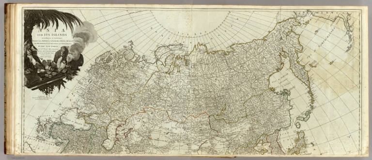
Author
Kitchin, Thomas
Full Title
Asia and its islands according to d'Anville; divided into empires, kingdoms, states, regions, &ca. with the European possessions and settlements in the East Indies and an exact delineation of all the discoveries made in the eastern parts by the English under Captn. Cook. (Northern section. By Thomas Kitchin). London, printed for Robert Sayer, Fleet Street as the Act directs, 6 Jany. 1787.
List No
0411.028
Note
Engraved map in outline color. Printed on 2 sheets. Relief shown pictorially. Includes historical and geographical notes. Ornamental cartouche. David Rumsey Collection copy mounted as 1 sheet.
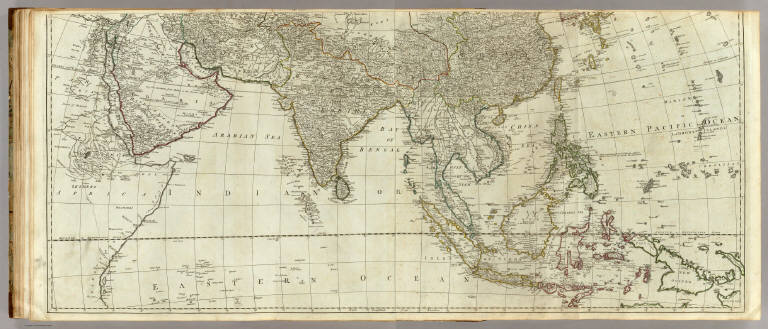
Author
Kitchin, Thomas
Full Title
(Asia and its islands according to d'Anville; divided into empires, kingdoms, states, regions, &ca. with the European possessions and settlements in the East Indies and an exact delineation of all the discoveries made in the eastern parts by the English under Captn. Cook. Southern section. By Thomas Kitchin. London, printed for Robert Sayer, Fleet Street as the Act directs, 6 Jany. 1787)
List No
0411.029
Note
Engraved map in outline color. Printed on 2 sheets. Relief shown pictorially. Includes historical and geographical notes. David Rumsey Collection copy mounted as 1 sheet.
Author
Kitchin, Thomas
Full Title
(Composite of) Asia and its islands according to d'Anville; divided into empires, kingdoms, states, regions, &ca. with the European possessions and settlements in the East Indies and an exact delineation of all the discoveries made in the eastern parts by the English under Captn. Cook. (By Thomas Kitchin). London, printed for Robert Sayer, Fleet Street as the Act directs, 6 Jany. 1787.
List No
0411.030
Note
Engraved map in outline color. Printed on 4 sheets. Relief shown pictorially. Includes historical and geographical notes. David Rumsey Collection copy mounted as 2 sheets. (E 20--W 165/N 80--S 13)
Author
Moll, Herman, d. 1732
Full Title
The Empire of China and island of Japan, agreeable to modern history. By H. Moll Geographer. (Printed and sold by T. Bowles next ye Chapter House in St. Pauls Church yard, & I. Bowles at ye Black Horse in Cornhill, 1736?)
List No
5580.037
Note
Hand col. engraved map. Relief shown pictorially. Includes geographic notes.
Author
Pinkerton, John, 1758-1826
Full Title
Japan. Drawn under the direction of Mr. Pinkerton by L. Hebert. Neele sculpt. 352 Strand. London: published 1st. March 1809, by Cadell & Davies, Strand & Longman, Hurst, Rees, Orme, & Brown, Paternoster Row.
List No
0732.035
Note
Engraved map. Full hand col. Relief shown by hachures. Covers also Korea. "Pinkerton's modern atlas."
Author
Robert de Vaugondy, Gilles, 1688-1766
Full Title
(Title Page to) Atlas Universel, Par M. Robert Geographe ordinaire du Roy, et Par M. Robert De Vaugondy son fils Geographe ord. du Roy, et de S. M. Polonoise, Duc de Lorraine et de Bar, et Associe de L'Academie Royale des Sciences et belles Lettres de Nancy, Avec Privilege Du Roy, 1757. A Paris, Chez Les Auteurs ,Quay de l'Horloge du Palais, Boudet Libraire Imprimeur du Roi, rue St. Jacques. Grave par Ch. Baquoy. J. Oger Scripsit.
List No
3353B
Note
1st edition, with five postal maps added, as issued. With the list of subscribers and the extra postal maps of England, France, Germany, Italy and Spain. The French postal map is dated 1758. All five were added after the printed list of maps was printed, but are mentioned by Vaugondy in the preface, so they may have been an afterthought. An owner has added their titles to the printed list of maps, in ms. Engraved title page, Advertisement, and Geographical essay giving the sources of the maps. This atlas was reissued until 1799 (Phillips), with later issues having a map of the United States. In original half leather patterned paper covered boards with spine reading "Nouvel Atlas De Mrs. Robert." One of the first atlases based on scientific surveys, in the tradition of D'Anville and De L'Isle. Outline color.
Author
Robert de Vaugondy, Gilles, 1688-1766
Full Title
L'Empire du Japon, divise en sept principales parties, et subdivise en soixante et six royaumes, par le Sr. Robert Geog. ord. du Roi. Avec Privilege. 1750.
List No
3353.095
Note
Engraved map. Hand col. borders. Relief shown pictorially. Ornamental cartouche. Covers also eastern Korea.
Author
Anville, Jean Baptiste Bourguignon d, 1697-1782
Full Title
Seconde partie de la carte d'Asie, contenant la Chine et partie de la Tartarie, l'Inde au dela du Gange, les isles Sumatra, Java, borneo, Moluques, Philippines, et du Japon. Publiee sous les auspices de Monseigneur Louis-Philippe d'Orleans, Duc d'Orleans, Premier Prince du Sang. Par le Sr. d'Anville, Secretaire de Son Alt? Sereniss? Guill? De la Haye Scul. A Paris, chez l'Auteur, aux Galeries du Louvre. M.DCC.LII.
List No
2603.006
Note
Engraved map on 2 sheets. Country boundaries hand col. Relief shown pictorially. Includes geographic notes and ornamental cartouche. David Rumsey Collection copy mounted as 1 sheet. Hand numbered "6" on verso.
Author
La Perouse, Jean-Francois de Galaup, comte de, 1741-1788
Full Title
Carte des decouvertes, faites en 1787 dans les mers de Chine et de Tartarie, par les Fregates Francaises la Boussole et l'Astrolabe, depuis leur depart de Manille jusqu'a leur arrivee au Kamtschatka. 1ere. feuille. Gravee par Bouclet. Ecrit par Herault. Atlas du Voyage de la Perouse no. 43. (Paris: L'Imprimerie de la Republique, An V, 1797)
List No
3355.043
Note
Engraved map. Relief shown by hachures; depths by soundings. Shows route of La Perouse. Prime meridian: Paris.
Author
La Perouse, Jean-Francois de Galaup, comte de, 1741-1788
Full Title
Plan de la partie de l'Ile de Quelpaert vue le 21. May 1787 par les Fregates Francaises la boussole et l'Astrolabe ... Plan de l'Ile Hoapinsu et des ilots qui l'environnent ... Plan de l'Ile Dagelet ... Plan de la partie de l'Ile de Botol ... Plan de l'Ile de Kumi ... L. Aubert scripsit. Atlas du Voyage de la Perouse no. 44. (Paris: L'Imprimerie de la Republique, An V, 1797)
List No
3355.045
Note
Five engraved maps. Relief shown by hachures.
Author
Rand McNally and Company
Full Title
Rand, McNally & Company's indexed atlas of the world map of Japan. Copyright 1892, by Rand, McNally & Co. (Chicago, 1897)
List No
3565.034
Note
Col. map in 2 segments. Relief shown by hachures and spot heights. Insets: Outline map of Japan. Scale (ca. 1:22,000,000) -- Ryukyu Islands. Scale (ca. 1:5,300,000) -- (Taka and Matsu islands -- South Extension of Osumi Province. Title in margin: Rand, McNally & Company's indexed atlas of the world.
Author
La Perouse, Jean-Francois de Galaup, comte de, 1741-1788
Full Title
(Title Page to) Atlas du voyage de La Perouse. Dessine par J. M. Moreau le Jeune. Grave par Ph. Triere. L. Aubert scripsit.
List No
3355B
Note
Engraved, illustrated title page. Some figures looking at unfolding map entitled: Developement de la route de La Perouse.
Author
La Perouse, Jean-Francois de Galaup, comte de, 1741-1788
Full Title
Carte des decouvertes, faites en 1787 dans les mers de Chine et de Tartarie, par les Fregates Francaises la Boussole et l'Astrolabe, depuis leur depart de Manille jusqu'a leur arrivee au Kamtschatka. 2e. feuille. Atlas du Voyage de la Perouse no. 46. (Paris: L'Imprimerie de la Republique, An V, 1797)
List No
3355.046
Note
Engraved map. Relief shown by hachures and pictorially; depths by soundings. Shows route of La Perouse. Prime meridian: Paris.
Author
[La Perouse, Jean-Francois de Galaup, comte de, 1741-1788, Vries, Maarten Gerritszoon]
Full Title
Carte des decouvertes au nord du Japon. Faites en 1643 par les Vaisseaux Hollandais le Kastrikum et le Breskens, comprenant la Terre de Jeso, l'Ile des Etats et la Terre de la Compagnie, dont partie a ete reconnue en 1787 par les Fregates Francaises la Boussole et l'Astrolabe. Ecrit par Herault. (with) Vue de la Terre de la Compagnie. Atlas du Voyage de la Perouse no. 47. (Paris: L'Imprimerie de la Republique, An V, 1797)
List No
3355.047
Note
Engraved map. Inset maps: Extrait de la carte publiee par Scheuchzer -- Extrait de la carte de l'Histoire du Japon de Kampfer. Relief shown pictorially; depths by soundings. Oriented with north toward right.
Author
[Blondela, Lieut., La Perouse, Jean-Francois de Galaup, comte de, 1741-1788]
Full Title
Bateau japonais. Dessine par Blondela. Grave par Le Pagelet. L. Aubert scripsit. Atlas du Voyage de la Perouse, no. 59. (Paris: L'Imprimerie de la Republique, An V, 1797)
List No
3355.059
Note
Two engraved drawings.
Author
Bonne, Rigobert, 1727-1794
Full Title
L'Empire de la Chine d'apres l'atlas chinois, avec les Isles du Japon. Par M. Bonne, Hydrographe du Roi, au Bureau de la Marine. A Paris, Chez Lattre Graveur, rue St. Jacques a la Ville de Bordeaux. Avec priv. du Roy. (1791)
List No
2612.058
Note
Engraved map. Boundaries outlined in hand col. Relief shown pictorially. Ornamental cartouche. Prime meridian: Ferro.
Author
Society for the Diffusion of Useful Knowledge (Great Britain)
Full Title
Empire of Japan. (with) Nagasaki Harbour. Engraved by J. & C. Walker. Published under the superintendence of the Society for the Diffusion of Useful Knowledge. Published Decr. 1st. 1835, by Chapman & Hall 186 Strand, London. (1844)
List No
0890.110
Note
Engraved map. Relief shown by hachures. Hand col. Includes inset "Eastern point of Yeso," i.e., continuation of map. Nagasaki harbor map at scale (ca. 1:115,000)
Author
Johnston, Alexander Keith, 1804-1871
Full Title
China and Japan by Keith Johnston, F.R.S.E. (with) Islands of Japan. Engraved & printed by W. & A.K. Johnston, Edinburgh. William Blackwood & Sons, Edinburgh & London, (1861)
List No
0373.039
Note
Engraved map. Boundaries hand col.; hydrography printed in blue. Relief shown by hachures. Inset map at 1:7,967,691 scale. "Keith Johnston's general atlas 34."
Author
Radefeld, Carl Christian Franz, 1788-1874
Full Title
Chinesische Reich mit seinen Schutzstaaten nebst dem Japanischen Inselreiche. Nach den besten Quellen entw. u. gezeichnet vom Hauptm. C. Radefeld. 1846. (with) Gegend zwischen Canton und Macao. (with) Peking. Stich, Druck und Verlag des Bibliographischen Instituts in Hildburghausen, (1860)
List No
4807.114
Note
Engraved map. Boundaries hand col. Relief shown by hachures. "Meyer's Handatlas No. 98." Prime meridians: Paris and Ferro.
Author
Garnier, F. A., 1803-1863
Full Title
Asie spheroidale. Atlas spheroidal & universel de geographie dresse par F.A. Garnier, geographe. Paris, Ve. Jules Renouard, Editeur, R. de Tournon, no. 6, Fg. St. Gin. 1860.
List No
5023.016
Note
Full col. Relief shown hachures. Prime meridian: Paris. On globe in cartouche: Sphericite de la terre.
Author
Garnier, F. A., 1803-1863
Full Title
Asie Orientale, Chine & Japon. Atlas spheroidal & universel de geographie dresse par F.A. Garnier, geographe. Vve. Jules Renouard, Editeur, Rue de Tournon, no. 6, Paris. 1860. Imp. de Sarazin, 8 r. Git-le-Coeur, Paris.
List No
5023.042
Note
Full col. Relief shown by hachures and spot heights. Prime meridian: Paris. On globe in cartouche: Sphericite de la terre.
Author
[Arrowsmith, John, Marzolla, Benedetto, Society for the Diffusion of Useful Knowledge (Great Britain)]
Full Title
Impero del Giappone. Questa Carta e stata eseguita su quella pubblicata in Londra nel 1835, dalla Societa per la diffusione delle utili conoscenze, e su quella di Arrowsmith; e fa parte del l'Atlante Geografico che si pubblica da B. Marzolla. Napoli 1847.
List No
4714.030
Note
Lithographed map. Borders hand col. Relief shown by hachures. Inset: Porto di Nangasaki (scale ca. 1:115,000). Includes notes and statistical tables.
1-45 of 45
|