Author
Humboldt, Alexander von, 1769-1859
Full Title
(Title Page to) Atlas Geographique Et Physique Du Royaume De La Nouvelle-Espagne, Fonde Sur Des Observations Astronomiques, Des Mesures Trigonometriques Et Des Nivellemens Barometriques. Par Al. De Humboldt. Paris, Chez F. Schoell, Rue Des Fosses-Saint-Germain-L'Auxerrois, No. 29. 1811. De L'Imprimerie De J.H. Stone.
List No
0328C
Note
First French edition (although some copies have 1808 on the title page). Stamp of Russian Imperial Library at Tsarkoe Selo. This atlas has the important "Carte Generale du Royaume de la Nouvelle Espagne" on two large folio sheets, originally drawn by Humboldt in 1803-4. Arrowsmith and Pike used this map as a base for their maps of Mexico and the southwest. Maps are without color and bound in full brown leather covered boards with "Voyage De Humboldt Et Bonplan. Atlas Geographique Et Physique Du Royaume De La Nouvelle-Espagne." stamped on the spine in black ink.
Author
Humboldt, Alexander von, 1769-1859
Full Title
(Index Page 1 to) Atlas Geographique Et Physique Du Royaume De La Nouvelle-Espagne, Fonde Sur Des Observations Astronomiques, Des Mesures Trigonometriques Et Des Nivellemens Barometriques. Par Al. De Humboldt. Paris, Chez F. Schoell, Rue Des Fosses-Saint-Germain-L'Auxerrois, No. 29. 1811. De L'Imprimerie De J.H. Stone.
List No
0328D
Author
Humboldt, Alexander von, 1769-1859
Full Title
(Index Pages 2-3 to) Atlas Geographique Et Physique Du Royaume De La Nouvelle-Espagne, Fonde Sur Des Observations Astronomiques, Des Mesures Trigonometriques Et Des Nivellemens Barometriques. Par Al. De Humboldt. Paris, Chez F. Schoell, Rue Des Fosses-Saint-Germain-L'Auxerrois, No. 29. 1811. De L'Imprimerie De J.H. Stone.
List No
0328E
Author
Humboldt, Alexander von, 1769-1859
Full Title
(Index Page 4 to) Atlas Geographique Et Physique Du Royaume De La Nouvelle-Espagne, Fonde Sur Des Observations Astronomiques, Des Mesures Trigonometriques Et Des Nivellemens Barometriques. Par Al. De Humboldt. Paris, Chez F. Schoell, Rue Des Fosses-Saint-Germain-L'Auxerrois, No. 29. 1811. De L'Imprimerie De J.H. Stone.
List No
0328F
Author
Humboldt, Alexander von, 1769-1859
Full Title
Carte Generale Du Royaume De La Nouvelle Espagne depuis le Parallele de 16¼ jusqu'au Parallele de 38¼ (Latitude Nord). Dressee Sur des Observations Astronomiques et sur l'ensemble des Materiaux qui existoient a Mexico, au commencement de l'annee 1804. Par Alexandre de Humboldt. Ls. Aubert pere Scripsit. 1. Dessine a Mexico par l'Auteur en 1804, perfectionne par le meme, par M.M. Friesen, Oltmanns, et Thuilier 1809. Grave par Barriere - et l'Ecriture par L. Aubert pere, a Paris.
List No
0328.001
Note
Top half of map of Mexico with Santa Fe near the middle of the uncolored map. Louisiana is to the right and the Gulf of Mexico to the left. Taos is shown as the northernmost village.
Author
Humboldt, Alexander von, 1769-1859
Full Title
Carte Generale Du Royaume De La Nouvelle Espagne depuis le Parallele de 16¼ jusqu'au Parallele de 38¼ (Latitude Nord). Dressee Sur des Observations Astronomiques et sur l'ensemble des Materiaux qui existoient a Mexico, au commencement de l'annee 1804. Par Alexandre de Humboldt. Ls. Aubert pere Scripsit. 1(bis). Dessine a Mexico par l'Auteur en 1804, perfectionne par le meme, par M.M. Friesen, Oltmanns, et Thuilier 1809. Grave par Barriere - et l'Ecriture par L. Aubert pere, a Paris.
List No
0328.002
Note
Bottom half of Mexico. This section of the map includes the legend and is without color.
Author
Humboldt, Alexander von, 1769-1859
Full Title
(Composite Map of) Carte Generale Du Royaume De La Nouvelle Espagne depuis le Parallele de 16¼ jusqu'au Parallele de 38¼ (Latitude Nord). Dressee Sur des Observations Astronomiques et sur l'ensemble des Materiaux qui existoient a Mexico, au commencement de l'annee 1804. Par Alexandre de Humboldt. Ls. Aubert pere Scripsit. 1. and 1(bis). Dessine a Mexico par l'Auteur en 1804, perfectionne par le meme, par M.M. Friesen, Oltmanns, et Thuilier 1809. Grave par Barriere - et l'Ecriture par L. Aubert pere, a Paris.
List No
0328.003
Note
Composite map of Mexico. Without color.
Author
Humboldt, Alexander von, 1769-1859
Full Title
Carte Du Mexique et des Pays Limitrophes Situes Au Nord et a l'est Dressee d'apres la Grande Carte de la Nouvelle Espagne De Mr. A. De Humboldt et d'autres Materiaux par J.B. Poirson. 1811. 2. Grave par Barriere. et l'ecriture par L. Aubert. Se trouve a Paris chez F. Schoell, Libraire.
List No
0328.004
Note
An uncolored map of Mexico, the United States and the West Indies.
Author
Humboldt, Alexander von, 1769-1859
Full Title
Carte De La Vallee De Mexico Et Des Montagnes Voisines esquissee sur les Lieux en 1804, par Don Louis Martin redigee et corrigee en 1807 d'apres les operations Trigonometriques de Don Joaquin Velasquez et d'apres les observations Astronomiques et les mesures Barometriques de Mr. De Humboldt par Jabbo Oltmanns. 3. Dessine par G. Grossmann, termine par F. Friesen a Berlin 1807 et par A. Humboldt a Paris 1808. Grave par Barriere - et l'Ecriture par L. Aubert pere.
List No
0328.005
Note
Map without color, includes cities, villages, haciendas, and astronomical observatory points.
Author
Humboldt, Alexander von, 1769-1859
Full Title
Points de partage et Communications projettees entre le Grand Ocean et l' Ocean Atlantique. (with) eight maps. 4. Dessines par J.B. Poirson. Grave par Barriere - et l'ecriture par L. Aubert.
List No
0328.006
Note
Eight uncolored maps showing possible communication points, and passageways from the Pacific Ocean to the Atlantic. The largest map is entitled: Carte de l'Isthme de Huasacualco.
Author
Humboldt, Alexander von, 1769-1859
Full Title
Carte Reduite de la Route d' Acapulco a Mexico, Dresee sur des Observations Astronomiques et sur un nivellement Barometrique par A. de Humboldt. 5. Dessine par A. de Humboldt, a Berlin 1807. Grave par Barriere et l'Ecriture par L. Aubert.
List No
0328.007
Note
A map showing the route from Acapulco to Mexico City. The map includes cities, towns, villages, mines, farms, and astronomical observatory points. Uncolored.
Author
Humboldt, Alexander von, 1769-1859
Full Title
Carte de la Route qui mene depuis la Capitale de la Nouvelle Espagne jusqu'a S. Fe de Nouveau Mexique. Dressee sur les Journaux de Don Pedro de Rivera et en partie sur les Observations Astronomiques de Mr. de Humboldt. 6-8. Dessine et redige par F. Friesen, a Berlin 1807.
List No
0328.008
Note
Three separate maps show the route from Mexico City to Santa Fe, New Mexico. Map six is the route from Mexico to Durango, seven from Durango to Chihuahua, and eight from Chihuahua to Santa Fe. Mines, ranchos, haciendas, villages and towns are shown.
Author
Humboldt, Alexander von, 1769-1859
Full Title
Carte reduite de la Partie oreintale de la Nouvelle Espagne depuis le Plateau de la Ville de Mexico jusqu'au Port de la Veracruz. Dressee sur les operations Geodesiques de Don Miguel Costanzo et de Dn. Dgo. Garcia Conde, Officers au Service de Sa Majeste Catholique sur les Observations Astronomiques et le Nivellement Barometrique de Mr. De Humboldt. 9. Dessinee d'apres l'esquise de Mr. de Humboldt par F. Friesen, a Berlin 1807. Le Plan grave par Barriere et l'Ecriture par L. Aubert, directeur du dit ouve. a Paris.
List No
0328.009
Note
Map details the region from Mexico City to Veracruz. Uncolored.
Author
Humboldt, Alexander von, 1769-1859
Full Title
Carte de Fausses Positions de Mexico, Acapulco, Veracruz et du Pic d'Orizaba. 10. Dessine par A. de Humboldt a Mexico 1804. Grave par L. Aubert.
List No
0328.010
Note
Map showing the incorrect positions ascribed to Mexico City, Acapulco, Veracruz and Orizaba over time, and by whom.
Author
Humboldt, Alexander von, 1769-1859
Full Title
Plan du Port de Veracruz, Dresse par Don Bernardo de Orta, Capitaine de Vaisseau au service de Sa Majeste Catholique. 11. F. Bauza s. a Madrid. (copie et diminue de moitie par F. Wittich 1807.) d'apres le Plan publie par le Deposito hydrografico de Madrid. Le Plan grave par Barriere et l'Ecriture par L. Aubert, directeur. Paris.
List No
0328.011
Note
A detailed plan of the port of Veracruz with soundings, and an inset view of the coast. Uncolored.
Author
Humboldt, Alexander von, 1769-1859
Full Title
Tableau physique de la pente Orientale du Plateau de la Nouvelle Espagne (Chemin de Mexico a Veracruz par Puebla et Xalapa.) Dresse d'apres des mesures Barometriques et Trigonometriques, prises en 1804 par Mr. de Humboldt. 12. Dessine par A. de Humboldt, a Veracruz 1804. Termine par Wittich et Friesen 1807. Grave par Bouquet. Les Echelles et l'Ecriture gravees par Aubert.
List No
0328.012
Note
A cross section depicting the elevations from Mexico City to Veracruz. Geologic information is also included.
Author
Humboldt, Alexander von, 1769-1859
Full Title
Tableau physique de la pente Occidental du Plateau de la Nouvelle Espagne (Chemin de Mexico a Acapulco) Dresse d'apres des mesures Barometriques prises en 1803 par Mr. de Humboldt. 13. Dessine par Wittich d'apres une esquise de Mr. Humboldt 1807. Grave par Bouquet. Les Echelles et l'Ecriture gravees par Aubert.
List No
0328.013
Note
A cross section depicting the elevations from Acapulco to Mexico City. Geologic information is also included.
Author
Humboldt, Alexander von, 1769-1859
Full Title
Tableau du Plateau central des Montagnes du Mexique, entre les 19 et 21¼ de Latitude boreale (Chemin de Mexico a Guanaxuato) Dresse d'apres le Nivellement Barometrique de Mr. de Humboldt. 14. Esquise par Alex. Mr. Humboldt a Mexico 1803. Dessine par Raphael Davalos a Mexico 1804 (termine a Berlin 1807). Grave par Bouquet. Les Echelles et l'Ecriture gravees par Aubert.
List No
0328.014
Note
A cross section depicting the elevations from Mexico City to Guanaxuato. Geologic information is also included.
Author
Humboldt, Alexander von, 1769-1859
Full Title
Profile du Canal de Huehuetoca (Desague Real.) Creuse pour preserver la Ville de Mexico du danger des Inondations. 15. Redige d'apres les dessins de Don Ignacio Castera et Don Luis Martin par F. Friesen 1808. Grave par Bouquet - et l'Ecriture gravee par L. Aubert pere.
List No
0328.015
Note
Profile of the Hueheutoca canal. In color.
Author
Humboldt, Alexander von, 1769-1859
Full Title
Volcans de la Puebla, vus depuis la Ville de Mexico de l'Imprimerie de Langlois. 16. Fr. Gmelin perf. Romae 1805. Lud. Martin ad nat. del. 1803. Fr. Arnold sc. Berol. 1807.
List No
0328.016
Note
View of the volcanos from Mexico City.
Author
Humboldt, Alexander von, 1769-1859
Full Title
Pic d' Orizaba vu depuis la Foret de Xalapa. de l'Imprimerie de Langlois. 17. Fr. Gmelin perf. Romae 1805. A. de Humboldt ad nat. del. 1804. Fr. Arnold sc. Berol. 1807.
List No
0328.017
Note
View of Orizaba.
Author
Humboldt, Alexander von, 1769-1859
Full Title
Plan du Port d'Acapulco. Dresse par les Officiers de la Marine Royale de S.M.C. embarques sur les Corvettes la Descubierta et l'Atrevida lannee 1791. 18. Grave par Barriere. Dessine a Madrid au Depot Hydrographique. l'Ecriture par L. Aubert.
List No
0328.018
Note
Plan of the port of Acapulco without color. Soundings shown.
Author
Humboldt, Alexander von, 1769-1859
Full Title
Carte des diverses Routes par lesquelles les richesses metalliques refluent d'un Continent a l'autre. 19. Dessine par J.B. Poirson d'apres une exquisee de Mr. de Humboldt. Grave par L. Aubert.
List No
0328.019
Note
One world map showing the trade routes, and four charts detailing the amount and monetary worth of the gold taken from the mines of Mexico and South America. Date estimated as the last information on the gold production is from 1802. Uncolored.
Author
Humboldt, Alexander von, 1769-1859
Full Title
I. Tableau comparatif de l'etendue territoriale des Intendances de la Nouvelle-Espagne. II. Etendue territoriale et Population des Metropoles et des Colonies en 1804. 20.
List No
0328.020
Note
Two charts showing relative size of the Mexican territories and population figures in the Colonies as of 1804.
Author
King, Clarence
Full Title
(Covers to) Engineer Department U.S.A. Geological and Topographical Atlas Accompanying the Report of the Geological Exploration of the Fortieth Parallel Made by the Authority of the Honorable Secretary of War under the direction of Brig. and Brvt. Major General A.A. Humphreys, Chief of Engineers U.S.A. by Clarence King, U.S. Geologist in Charge, 1876. Julius Bien Lith.
List No
0408A
Author
King, Clarence
Full Title
(Title Page to) Engineer Department U.S.A. Geological and Topographical Atlas Accompanying the Report of the Geological Exploration of the Fortieth Parallel Made by the Authority of the Honorable Secretary of War under the direction of Brig. and Brvt. Major General A.A. Humphreys, Chief of Engineers U.S.A. by Clarence King, U.S. Geologist in Charge, 1876. Julius Bien Lith.
List No
0408B
Note
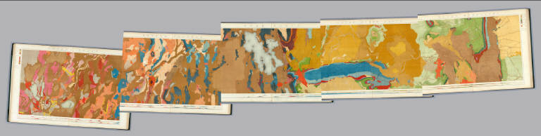
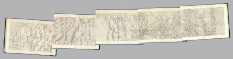
Magnificent, huge atlas showing the area of the 40th Parallel Survey in topographical and geological maps. Wheat notes: "These are pioneer survey maps, and as such are most interesting. Mapping the West in so broad a cross-section had never before been attempted, a portent of things to come." King, at the age of 25, was made Geologist-in-charge of the Survey in 1867. He was formally ordered "to examine and describe the geological structure, geographical condition and natural resources of a belt of country extending from the 120th meridian eastward to the 105th meridian, along the 40th parallel of latitude with sufficient expansion north and south to include the lines of 'Central' and 'Union Pacific' railroads..." (Wheat). The topographical sheets depict features by brush shading rather than hachuring. In original binding -rare. Bound in green half leather with a label on the front, "Geological and Topographical Atlas Accompanying the Report of the Geological Exploration of the Fortieth Parallel. Clarence King, Geologist in Charge."
Author
King, Clarence
Full Title
(Index Page to) Engineer Department U.S.A. Geological and Topographical Atlas Accompanying the Report of the Geological Exploration of the Fortieth Parallel Made by the Authority of the Honorable Secretary of War under the direction of Brig. and Brvt. Major General A.A. Humphreys, Chief of Engineers U.S.A. by Clarence King, U.S. Geologist in Charge, 1876. Julius Bien Lith.
List No
0408C
Note
Index page includes the list of maps and a legend naming the mapmakers and the basis by which the maps were made.
Author
King, Clarence
Full Title
Cordilleras.
List No
0408.001
Note
Map in what came to be known as "plastic shading." The development of halftone lithography made this technique possible. The technique depicts surface features by brush shading rather than the more conventional hachuring. The map is in brown tones with the index maps highlighted in red.
Author
King, Clarence
Full Title
Rocky Mountains. Map I. (Geological)
List No
0408.002
Note
Map in full color with the legends on either side of the maps. Map extends from Cheyenne in the east to Fortification Peak in the west (Wyoming). Below the map are two geologic cross sections.
Author
King, Clarence
Full Title
Green River Basin. Map II. (Geological)
List No
0408.003
Note
Map in full color with the legends on either side of the maps. Map extends from Fortification Peak in Wyoming to Piedmont in Utah. Below the map are two geologic cross sections.
Author
King, Clarence
Full Title
Utah Basin. Map III. (Geological)
List No
0408.004
Note
Map in full color with the legends on either side of the maps. Map extends from Piedmont in Utah to Bovine, Utah including the Great Salt Lake. Below the map are two geologic cross sections.
Author
King, Clarence
Full Title
Nevada Plateau. Map IV. (Geological)
List No
0408.005
Note
Map in full color with the legends on either side of the maps. Map extends from Bovine, Utah across the Nevada plateau to Argenta, Nevada. Below the map are two geologic cross sections.
Author
King, Clarence
Full Title
Nevada Basin. Map V. (Geological)
List No
0408.006
Note
Map in full color with the legends on either side of the maps. Map extends from Argenta, Nevada to the west of Pyramid Lake (Lake Tahoe) in California. Below the map are two geologic cross sections.
Author
King, Clarence
Full Title
(Composite of) Geological Maps I-V, 40th Parallel Survey.
List No
0408.007
Note
Maps in full color with the legends on either side of the maps.
Author
King, Clarence
Full Title
General Sections.
List No
0408.008
Note
In full color. Ten sections shown with the legends on either side of the cross sections.
Author
King, Clarence
Full Title
Rocky Mountains. Map I. (Topographical)
List No
0408.009
Note
Map in brown shaded relief. Map extends from Cheyenne in the east to Fortification Peak in the west (Wyoming).
Author
King, Clarence
Full Title
Green River Basin. Map II. (Topographical)
List No
0408.010
Note
Map in brown shaded relief. Map extends from Fortification Peak in Wyoming to Piedmont in Utah.
Author
King, Clarence
Full Title
Utah Basin. Map III. (Topographical)
List No
0408.011
Note
Map in brown shaded relief. Map extends from Piedmont in Utah to Bovine, Utah including the Great Salt Lake.
Author
King, Clarence
Full Title
Nevada Plateau. Map IV. (Topographical)
List No
0408.012
Note
Map in brown shaded relief. Map extends from Bovine, Utah across the Nevada plateau to Argenta, Nevada.
Author
King, Clarence
Full Title
Nevada Basin. Map V. (Topographical)
List No
0408.013
Note
Map in brown shaded relief. Map extends from Argenta, Nevada to the west of Pyramid Lake (Lake Tahoe) in California.
Author
King, Clarence
Full Title
(Composite of) Topographical Maps I-V, 40th Parallel Survey.
List No
0408.014
Note
Maps in brown shaded relief.
Author
[Fremont, J.C., Preuss, Charles]
Full Title
Topographical Map Of The Road From Missouri To Oregon, Commencing At The Mouth Of The Kansas In The Missouri River And Ending At The Mouth Of The Wallah Wallah In The Columbia. In VII Sections. Section I. From the field notes and journal of Capt. J.C. Fremont, and from sketches and notes made on the ground by his assistant Charles Preuss. Compiled by Charles Preuss, 1846 By order of the Senate of the United States ... Lithogr. by E. Weber & Co. Baltimore ...
List No
2773.001
Note
Map includes a chart of meteorological observations giving remarks, the temperature reading, and the altitude. It is also noted that "This section abounds with grass, water and fuel so that emigrants may encamp almost anywhere." But, elk and deer, the only game, are very scarce.
Author
[Fremont, J.C., Preuss, Charles]
Full Title
Topographical Map Of The Road From Missouri To Oregon, Commencing At The Mouth Of The Kansas In The Missouri River And Ending At The Mouth Of The Wallah Wallah In The Columbia. In VII Sections. Section II. From the field notes and journal of Capt. J.C. Fremont, and from sketches and notes made on the ground by his assistant Charles Preuss. Compiled by Charles Preuss, 1846 By order of the Senate of the United States ... Lithogr. by E. Weber & Co. Baltimore ...
List No
2773.002
Note
Map includes a chart of meteorological observations giving remarks, the temperature reading, and the altitude. Buffalo are present in "inumerable bands," and it is suggested that the dung be used for fuel. Timber is scarce , except on the islands. It is noted that the Pawnee pose a threat to the traveler as they are likely to rob the emigrants along the route. A note from Fremont's report about the first viewing of the buffalo is included below the map.
Author
[Fremont, J.C., Preuss, Charles]
Full Title
Topographical Map Of The Road From Missouri To Oregon, Commencing At The Mouth Of The Kansas In The Missouri River And Ending At The Mouth Of The Wallah Wallah In The Columbia. In VII Sections. Section III. From the field notes and journal of Capt. J.C. Fremont, and from sketches and notes made on the ground by his assistant Charles Preuss. Compiled by Charles Preuss, 1846 By order of the Senate of the United States ... Lithogr. by E. Weber & Co. Baltimore ...
List No
2773.003
Note
Map includes a chart of meteorological observations giving remarks, the temperature reading, and the altitude. From the notes on the map, this appears to have been a difficult stretch of road. No game was found 30 miles each way from Fort Laramie. Grass was scanty as was fuel. It is stated that, "Sioux Indians are not to be trusted." Notes from Fremont's report states that Fort Laramie should be used as an established military post. It would make the whole area safer and could also continue to be a trading post.
Author
[Fremont, J.C., Preuss, Charles]
Full Title
Topographical Map Of The Road From Missouri To Oregon, Commencing At The Mouth Of The Kansas In The Missouri River And Ending At The Mouth Of The Wallah Wallah In The Columbia. In VII Sections. Section IV. From the field notes and journal of Capt. J.C. Fremont, and from sketches and notes made on the ground by his assistant Charles Preuss. Compiled by Charles Preuss, 1846 By order of the Senate of the United States ... Lithogr. by E. Weber & Co. Baltimore ...
List No
2773.004
Note
This section of the map includes the Wind River Mountains and a discussion of the continental divide by Fremont. In his report Fremont states, "We mounted the barometer in the snow of the summit ... giving 13, 570 feet for the elevation above the Gulf of Mexico. Fields of snow lay far below us: boundless mountains stretched before us. A stillness the most profound, and a terrible solitude, forced themselves constantly on the mind as the great features of this place." This section traverses the war ground of the Indians, and so it is noted that guards and watches should be in place.
Author
[Fremont, J.C., Preuss, Charles]
Full Title
Topographical Map Of The Road From Missouri To Oregon, Commencing At The Mouth Of The Kansas In The Missouri River And Ending At The Mouth Of The Wallah Wallah In The Columbia. In VII Sections. Section V. From the field notes and journal of Capt. J.C. Fremont, and from sketches and notes made on the ground by his assistant Charles Preuss. Compiled by Charles Preuss, 1846 By order of the Senate of the United States ... Lithogr. by E. Weber & Co. Baltimore ...
List No
2773.005
Note
Notes in this section include a mention of the Great Salt Lake as "one of the wonders of nature, and perhaps without a rival in the world..." The travelers were now out of danger from the Indians as the Snake Indians were considered to be friendly.
Author
[Fremont, J.C., Preuss, Charles]
Full Title
Topographical Map Of The Road From Missouri To Oregon, Commencing At The Mouth Of The Kansas In The Missouri River And Ending At The Mouth Of The Wallah Wallah In The Columbia. In VII Sections. Section VI. From the field notes and journal of Capt. J.C. Fremont, and from sketches and notes made on the ground by his assistant Charles Preuss. Compiled by Charles Preuss, 1846 By order of the Senate of the United States ... Lithogr. by E. Weber & Co. Baltimore ...
List No
2773.006
Note
The accompanying notes state, "This is the most trying section for the traveller on the whole route. Water, though good and plenty, is difficult to reach, as the river is hemmed in by high and vertical rocks and many of the bystreams are without water in the dry season. Grass is only to be found at the marked camping places, and barely sufficient to keep strong animals from starvation. Game there is none. The road is very rough by volcanic rocks, detrimental to wagons and carts. In sage bushes consists the only Fuel. Lucky, that by all these hardships the traveller is not harassed by the Indians, who are peacable & harmless."
Author
[Fremont, J.C., Preuss, Charles]
Full Title
Topographical Map Of The Road From Missouri To Oregon, Commencing At The Mouth Of The Kansas In The Missouri River And Ending At The Mouth Of The Wallah Wallah In The Columbia. In VII Sections. Section VII. From the field notes and journal of Capt. J.C. Fremont, and from sketches and notes made on the ground by his assistant Charles Preuss. Compiled by Charles Preuss, 1846 By order of the Senate of the United States ... Lithogr. by E. Weber & Co. Baltimore ...
List No
2773.007
Note
This map contains the largest amount of written data. Copious notes are included from October 10th through October 25th. The last note tells about the first sighting of the Columbia River. Fremont notes that the distance from the mouth of the Kansas to "this place" is about 2,000 miles. They were greeted at Fort Wallah-Wallah by Mr. McKinley, the commander of the post, who received them "with great civility."
Author
Vancouver, George, 1757-1798
Full Title
(Covers to) A Voyage Of Discovery To The North Pacific Ocean And Round The World In Which The Coast of North-West America Has Been Carefully Examined And Accurately Surveyed. Undertaken by His Majesty's Command, Principally With A View To Ascertain The Existence Of Any Navigable Communication Between The North Pacific and North Atlantic Oceans; And Performed In The Years 1790, 1791, 1792, 1793, 1794, and 1795 In The Discovery Sloop Of War, And Armed Tender Chatham, Under The Command Of Captain George Vancouver. In Three Volumes. London: Printed For G.G. And J. Robinson, Paternoster-Row; And J. Edwards, Pall-Mall. 1798.
List No
3354A
Author
Vancouver, George, 1757-1798
Full Title
(Title Page to) A Voyage Of Discovery To The North Pacific Ocean And Round The World In Which The Coast of North-West America Has Been Carefully Examined And Accurately Surveyed. Undertaken by His Majesty's Command, Principally With A View To Ascertain The Existence Of Any Navigable Communication Between The North Pacific and North Atlantic Oceans; And Performed In The Years 1790, 1791, 1792, 1793, 1794, and 1795 In The Discovery Sloop Of War, And Armed Tender Chatham, Under The Command Of Captain George Vancouver. In Three Volumes. London: Printed For G.G. And J. Robinson, Paternoster-Row; And J. Edwards, Pall-Mall. 1798.
List No
3354B
Note
Title page from the first volume describing the voyages. Atlas volume was printed without its own title page.
|