|
REFINE
Media Group: Early United States Wall Maps
1-15 of 15
Author
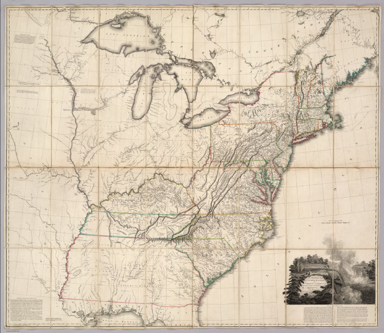
Arrowsmith, Aaron
Full Title
(Covers to) A Map Of The United States of North America Drawn from a number of Critical Researches By A. Arrowsmith, Geographer, Charles Street, Soho Square. London. Published as the Act Directs by A. Arrowsmith, Charles Street, Soho Square. Jany. 1st, 1796. Boundaries Communicated by Geo. Chalmers Esqr. ...
List No
3385A
Note
1st edition, 1st issue - "Tennassee Government." Many changes from the later 1808/1811 issue - the Great Lakes and the upper Mississippi are drawn very preliminarily and inaccurately, very few roads are shown throughout, there is a long note in the lower left corner about the boundaries of Georgia, parts of Maine and Canada are blank or inaccurately drawn, and Georgia and Tennessee have much less detail. Only the title sheet that shows the Carolinas and Virginia is about the same, except for fewer roads. As geographical knowledge increased about the parts north and west, Arrowsmith filled in this map. Outline color by state. In two sheets, each dissected into 16 sections and backed with linen. Folds into original tan marbled slip case 32x19 with a paste down label reading "North America. Date 1796" in ms, and "Sold by Wm. Allen 32 Dame Strt." printed in black ink.
Author
Arrowsmith, Aaron
Full Title
A Map Of The United States of North America Drawn from a number of Critical Researches By A. Arrowsmith, Geographer, Charles Street, Soho Square. London. Published as the Act Directs by A. Arrowsmith, Charles Street, Soho Square. Jany. 1st, 1796. Boundaries Communicated by Geo. Chalmers Esqr. ...
List No
3385.001
Note
1st edition, 1st issue - "Tennassee Government." Many changes from the later 1808/1811 issue - the Great Lakes and the upper Mississippi are drawn very preliminarily and inaccurately, very few roads are shown throughout, there is a long note in the lower left corner about the boundaries of Georgia, parts of Maine and Canada are blank or inaccurately drawn, and Georgia and Tennessee have much less detail. Only the title sheet that shows the Carolinas and Virginia is about the same, except for fewer roads. As geographical knowledge increased about the parts north and west, Arrowsmith filled in this map. Outline color by state. In two sheets, each dissected into 16 sections and backed with linen. Folds into original tan marbled slip case 32x19 with a paste down label reading "North America. Date 1796" in ms, and "Sold by Wm. Allen 32 Dame Strt." printed in black ink.
Author
Tardieu, P.F.
Full Title
United States of Nth. America. Carte des Etats-Unis de L'Amerique Septentrionale Copiee et Gravee sur celle d'Arrowsmith Corigee...
List No
0987.000
Note
First edition. This map is entirely a copy of Arrowsmith's Map of the United States (see our 1796 issue) except for certain parts (mentioned by Tardieu in his "Note" above the title) that Tardieu has altered and improved, based on other sources. A Plan of Washington, D.C. is also added. Later editions depart more radically from Arrowsmith and this actually becomes a better map in many respects (certainly more up to date regarding new States and Territories) than the Arrowsmith editions, although Arrowsmith remains better in the areas west of the Mississippi. G. Gibbs name on label- a famous scientist, see DAB. Map folds into a new brown cloth folding case 32x26 with "United States P.F. Tardieu 1802" stamped in gilt on the spine.
Author
Carleton, Osgood
Full Title
A New Map of the United States, of America Including part of Louisiana. Drawn from the latest Authorities. Revised and corrected by Osgood Carleton Esq. Teacher of Mathematics, Boston. Boston, Published and Sold by John Sullivan, Junr. 1806.
List No
5801.000
Note
Osgood Carleton first published a map of the United States in 1791. Another edition appeared in 1797, and then this edition in 1806. This issue is a major redrawing of the 1791 and 1797 maps, and it borrows heavily from Arrowsmith's Map of the United States, 1802 (see our list no. 5699.009, from Thompson's Alcedo Atlas, our 5699.000) especially in the west. But Carleton uses other sources as well, including Bradley's postal map. There was another issue of this map, undated, and updated to some unknown period, perhaps after 1810 or even later (Chris Lane, Philadelphia Print Shop).
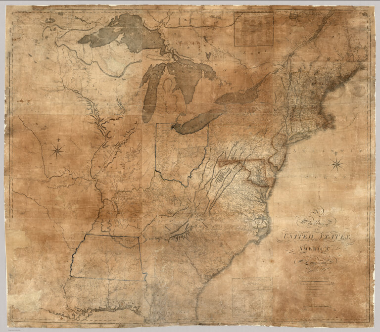
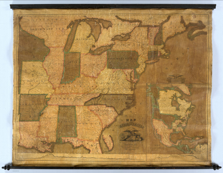
Author
Lewis, Samuel
Full Title
A New and correct Map of The United States Of North America; Exhibiting The Counties, Towns, Roads &c. in each State. Carefully compiled from Surveys and the most Authentic Documents, By Samuel Lewis. W. & S. Harrison sculpt. Philadelphia, Published by Emmor Kimber 1816. Copy Right secured according to Law.
List No
5047.000
Note
This is the first complete edition of this map, the largest wall map of the United States produced by Americans at that time (although Karrow 1-1418 lists an almost complete 1815 edition). Differences from the 1818 edition include Illinois and Indiana shown as Territories, a large Mississippi with no Alabama, and no Arkansas Territory. Also, there are far fewer roads shown, and fewer settlements laid down, especially in Canada. See our #432 for a proposal for publishing this map. With black top and bottom rollers and dark green linen edging. Outline color by state or territory.
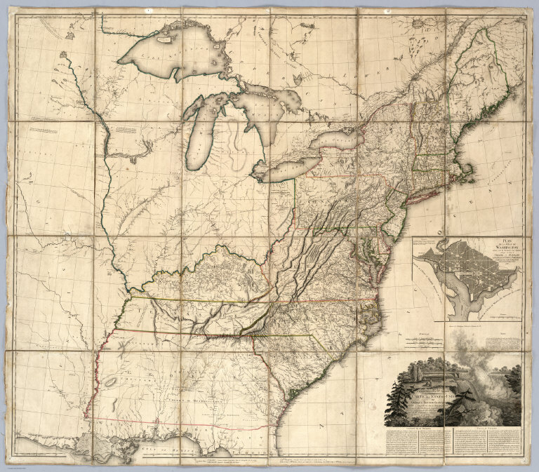
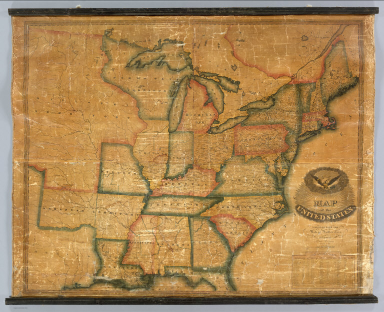
Author
Tardieu, P.F.
Full Title
(Covers to) United States of Nth. America. Carte des Etats-Unis de L'Amerique Septentrionale Copiee et Gravee sur celle d'Arrowsmith Corrigee et considerablem ent augmentee d'Apres les renseignemens les plus authentiques Par P.F. Tardieu, Graveur, Editeur-proprietaire. Place de l'Estrapade No. 1. 'A Paris 1812. a Paris, Ches: Tardieu ... Dezauche, Ingenieur Geographe, Rue des Noyers. Chles. Picquet, Geographe - Graveur Quai de la Monnaie No. 17. Treuttel et Wurtz, Libraire Rue de Lille No. 17 ... J. Goujon Marchand de Cartes Geographiques, Rue du Bac No. 6. Ecrit par J.J. Pachoux. (with 1 inset map).
List No
4397A
Note
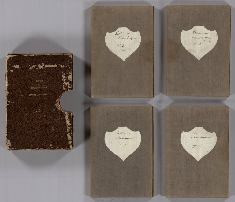
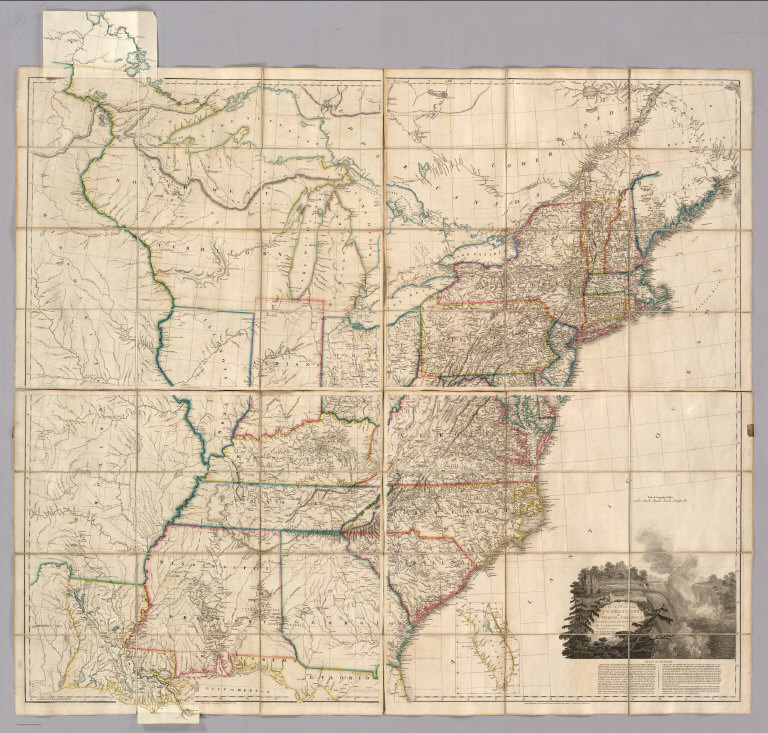
The date is estimated, the only date on the map being 1812. Compared to the 1812 edition, Alabama Territory is added (1817) and Mississippi is a state (1817). Indiana Territory has been divided into Illinois and Indiana Territories, Missouri Territory appears with Louisiana as a state (1812), and there are many additions of towns and roads in the Midwest and Southeast. Chicago appears. The only major topographical changes we can find are in the Florida/Georgia border and coast line. The next issue of this map was the 1820 dated issue. Comparing this map to the Arrowsmith "additions to 1819" issue of the Map of the United States, one is impressed that Tardieu's map is far more up to date. Even though Tardieu began by copying the Arrowsmith map, his editions are consistently more current with the political and topographical changes of the times. Map is in four sheets, each dissected into 15 sections, and backed and edged in linen. Outline color by state. Sheets folds into original brown marbled slip case 22x15 embossed in gold with "Metz. Ecole Royale D'Artillerie" on the front and "Tardieu. Etats-Unis D'Amerique" on the spine.
Author
Tardieu, P.F.
Full Title
United States of Nth. America. Carte des Etats-Unis de L'Amerique Septentrionale Copiee et Gravee sur celle d'Arrowsmith Corrigee et considerablem ent augmentee d'Apres les renseignemens les plus authentiques Par P.F. Tardieu, Graveur, Editeur-proprietaire. Place de l'Estrapade No. 1. 'A Paris 1812. a Paris, Ches: Tardieu ... Dezauche, Ingenieur Geographe, Rue des Noyers. Chles. Picquet, Geographe - Graveur Quai de la Monnaie No. 17. Treuttel et Wurtz, Libraire Rue de Lille No. 17 ... J. Goujon Marchand de Cartes Geographiques, Rue du Bac No. 6. Ecrit par J.J. Pachoux. (with 1 inset map).
List No
4397.001
Note
The date is estimated, the only date on the map being 1812. Compared to the 1812 edition, Alabama Territory is added (1817) and Mississippi is a state (1817). Indiana Territory has been divided into Illinois and Indiana Territories, Missouri Territory appears with Louisiana as a state (1812), and there are many additions of towns and roads in the Midwest and Southeast. Chicago appears. The only major topographical changes we can find are in the Florida/Georgia border and coast line. The next issue of this map was the 1820 dated issue. Comparing this map to the Arrowsmith "additions to 1819" issue of the Map of the United States, one is impressed that Tardieu's map is far more up to date. Even though Tardieu began by copying the Arrowsmith map, his editions are consistently more current with the political and topographical changes of the times. Map is in four sheets, each dissected into 15 sections, and backed and edged in linen. Outline color by state. Sheets folds into original brown marbled slip case 22x15 embossed in gold with "Metz. Ecole Royale D'Artillerie" on the front and "Tardieu. Etats-Unis D'Amerique" on the spine.
Author
Lewis, Samuel
Full Title
A New and Correct Map of the United States of North America; Exhibiting the Counties, Towns, Roads &c. in Each State. Carefully Compiled from Surveys and the Most Authentic Documents, by Samuel Lewis. W. & S. Harrison, sculpt. Philadelphia, Published by Kimber & Sharpless for Emmor Kimber 1818.
List No
4439.000
Note
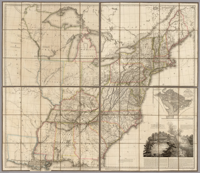
This is the second, unrecorded edition. The first complete edition was 1816, and the third edition, 1819. Ristow notes an incomplete issue (only the title sheet) of 1815. The 1818 and 1819 editions add an inset map of east Florida. This 1818 edition has a printed notation on the U.S. Mexican boundary: "Boundary between the U. States and the Spanish Provinces agreeable to the Treaty of 1819." This indicates that the map was published late in 1818 or early in 1819, either in anticipation of the February, 1819 signing of the treaty, or just after it. This is a huge map, almost six feet square, full of detail on roads, large and small towns, and areas that were "settling up." Like other large U.S. maps (other than the Melish) of the period (Shelton & Kensett, Varle, Bradley, Arrowsmith, Tardieu), this map extends west to just beyond the Mississippi River. It ranks as the largest in size and scale and is certainly the most detailed. And it is rare, with this 1818 copy being perhaps unique. It must have drawn much of its road information from the Bradley postal map of 1804/12. It is similar to the Arrowsmith 1819 in the northwestern areas, but closer to the Tardieu 1818 in the Michigan Peninsula area. It is not clear to us whether Lewis borrowed from Arrowsmith and Tardieu or vice versa, probably it worked both ways. For an enthusiastic contemporary evaluation of the first edition, see our 1815 copy of the advertisement for this map ("It is, we believe, much the largest specimen of geographical design ever produced in the United States...we do not think it equaled by any large map of European workmanship we have ever examined"). Lewis also made a smaller wall map of the U.S. titled "Traveler's Guide: A New and Correct Map of the United States..." in 1819, and another smaller still in 1817 titled "A Correct Map of the United States with the West Indies..." (see our copies).
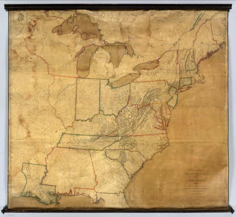
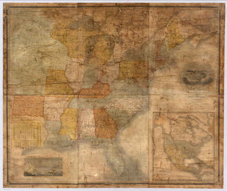
Author
Arrowsmith, Aaron
Full Title
(C0vers to) A Map Of The United States of North America Drawn from a number of Critical Researches By A. Arrowsmith, Hydrographer to His Majesty. No. 10 Soho Square. Additions to 1819. London. Published as the Act Directs by A. Arrowsmith, No. 10 Soho Square. Jan 1st, 1796. Additions to 1802 ... (inset map of Florida).
List No
3445A
Note
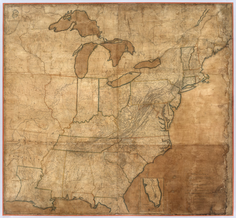
The last edition, with the "wings" on the Mississippi and the Northwest. Adds Illinois, Indiana, Ohio, Michigan, Louisiana, Mississippi and Missouri Territory. Many changes to the topography as well. An inset of the Florida Peninsula appears. The northern wing shows the Lake of the Woods and the southern wing shows the mouths of the Mississippi in detail. The delineation of the roads indicates that Bradley's Postal Map of the U.S. may have been used as a source. Outline color by state. Map is in four sheets, each dissected into 12 sections. Sheets fold into a new slip case 26x18 with the original tan covers pasted down with a label reading "J. Le Nesuvier (645) United States" in manuscript.
Author
Arrowsmith, Aaron
Full Title
A Map Of The United States of North America Drawn from a number of Critical Researches By A. Arrowsmith, Hydrographer to His Majesty. No. 10 Soho Square. Additions to 1819. London. Published as the Act Directs by A. Arrowsmith, No. 10 Soho Square. Jan 1st, 1796. Additions to 1802 ... (inset map of Florida).
List No
3445.001
Note
The last edition, with the "wings" on the Mississippi and the Northwest. Adds Illinois, Indiana, Ohio, Michigan, Louisiana, Mississippi and Missouri Territory. Many changes to the topography as well. An inset of the Florida Peninsula appears. The northern wing shows the Lake of the Woods and the southern wing shows the mouths of the Mississippi in detail. The delineation of the roads indicates that Bradley's Postal Map of the U.S. may have been used as a source. Outline color by state. Map is in four sheets, each dissected into 12 sections. Sheets fold into a new slip case 26x18 with the original tan covers pasted down with a label reading "J. Le Nesuvier (645) United States" in manuscript.
Author
Arrowsmith, Aaron
Full Title
A Map of the United States of North America Drawn from a number of Critical Researches ... Additions to 1819 (Western two sheets only). London, Published by A. Arrowsmith, No. 10 Soho Square Jan 1st 1796.
List No
4309.000
Note
Lacking the two eastern sheets which include the title. This issue is earlier slightly than our complete 1819 edition (Stevens 79 (i)) with less development shown in the area around the junction of the Ohio and Wabash Rivers, which were settling up rapidly at that time (see David Thomas "Travels Through The Western Country"). However, it has the northern and (most of) the southern flaps which place it later than Stevens 79 (h). So it is probably an unrecorded state of the map. Map has light blue silk edging, is dissected into 25 sections, and folds into a new blue cloth folding case 26x17 with "United States A. Arrowsmith 1819" stamped in gilt on the spine.
Author
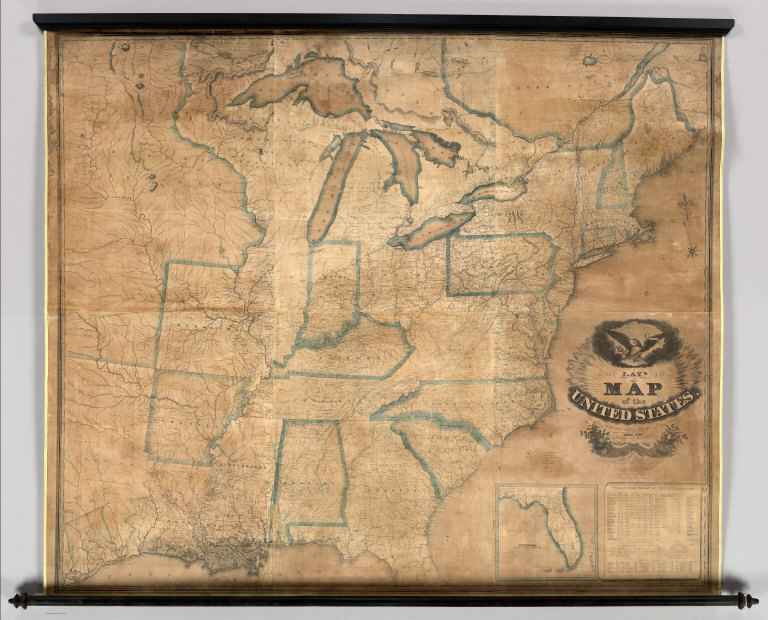
Lay, Amos
Full Title
Lay's Map of the United States. Compiled from the Latest and best Authorities and Actual Surveys By Amos Lay, Geographer and Map Publisher New York 1832. Engraved by O.H. & D.L. Throop & Wm. Chapin, New York. O.H. Throop, del. Entered ... May 8th 1827 By Amos Lay ... New York. (inset) Florida.
List No
5170.000
Note
Changes from the 1828 edition include: the Michigan Peninsula has been completely redrawn (probably following Tanner's 1832 Map of the United States, our #4406), the Statistical Tables have been filled in for 1830, and Texas is extensively altered adding much of the information from the Steven Austin Map of Texas of 1830, although incorrectly placing Galveston at the mouth of the Trinity River. Lay's showing of Texas in this edition, while not correct in every respect, is the best detailed depiction of Texas on any large map of the United States until Tanner's 1836 edition of his Map of the United States. With black top and bottom rollers, and light yellow cloth edging. Map is unvarnished and has blue outline color by state.
Author
Varle, Charles P.
Full Title
Map of the United States By Chas. Varle, Engineer and Geographer. New York, 1832. Revised and Republished by R. Stebbins & Co. (with) inset Map of North America. (with) inset map of South Part of Florida. (with) inset Physical Sections from "Washington City to Wheeling and from thence to the mouth of Columbia river" and from the "Pacific Ocean to the Gulf of Mexico."
List No
5468.000
Note
With black top and bottom sticks, mounted on linen. Outline color on main and inset maps. Physical sections differ in scale.
Author
Robinson, Lewis
Full Title
Map of the United States. Compiled From The Latest Authorities. Published By Lewis Robinson. Reading Vt. 1833. Engraved by J.G. Darby.
List No
4376.000
Note
The first edition. This differs from the later editions in not having any inset maps of cities and the Florida peninsula. There are far fewer towns and counties in the mid west and west. The Statistical Table is present under the title, but the two tables of towns are not present on the left side of the map. All in all, this has the look of a preliminary edition, with much information left out that appears in edition immediately following this one. Nonetheless, it is still a marvelous map, given its origins in Reading, Vermont. With black top and bottom rollers and outline color by state.
Author
[Finley, Anthony, Vance, David H.]
Full Title
Map Of The United States Of North America. Compiled from the Latest And Most Authentic Information By David H. Vance. Philadelphia Published by Anthony Finley. Entered according to Act of Congress. Engraved by J.H. Young. 1833. (inset) Map Of North America Including All The Recent Geographical Discoveries. (inset) Comparative Elevation of the Principal Mountains and Hills in the United States. (inset) Topographical View of the Chesapeake and Delaware Canal.
List No
4444.000
Note
This 1833 edition is later than any recorded edition (Karrow shows editions of 1825, 1829, and 1831). There are numerous changes from the 1825 edition: the addition of counties in the developing states, changes to the statistical table to include the census of 1830, new roads, the reduction of Arkansas Territory, and the addition of three canal profiles, two of which replace the steamboat route table and the other placed above the main title. Without rollers. Full color by state or territory.
1-15 of 15
|