Author
Lucas, Fielding Jr.
Full Title
(Title Page to) A General Atlas Containing Distinct Maps Of all the Known Countries in the World, Constructed from the Latest Authority. Written and Engraved by Jos. Perkins, Philadelphia. Baltimore: Published by Fielding Lucas, Jun. No. 138, Market Street. Baltimore. Entered ... by F. Lucas Jr. of the State of Maryland June 3, 1823.
List No
4584B
Note
The first edition, first state (see our first edition, second state for comparison, #444) of Lucas' best general atlas and the finest general atlas produced in the U.S. at the time (In asserting this we omit the Tanner and Finley American Atlases of 1823 and 1826 respectively because they were not general atlases - cartographically they may have been superior to the Lucas, but not as broad in coverage). The quality of the engraving (most of the U.S. maps were engraved by B.T. Welch, others by Young & Delker, J.V.N. Throop, Cone & Freeman, and Kneass) is superb, the detail is very fine, and the coloring is delicate and elegant. While the same Lucas drawn base maps were used iin this atlas and the 1822 American Atlas by Carey and Lea (and thereby created strained relations between him and Carey and Lea), the maps in this Lucas Atlas are far superior in quality - Welch reengraved many of the maps for Lucas that Young & Delker had engraved for Carey and Lea. It is interesting to note that the Carey and Lea maps are usually earlier states of the Lucas maps. The Atlantic Islands and the West Indies Island Maps are mostly copied from Thomson's General Atlas of 1817 (see our copy, #1007) as is the Mountains and Rivers plate (reduced). Many maps are derived from the earlier Lucas Atlas of 1815-17 which copied the Oddy Atlas maps for the non U.S. state maps. Some copies have solid color. Maps of Mexico, Canada, and N. America (updated by Lucas in the Arctic), are copied from Arrowsmith's "General Atlas" of 1823 (first ed. was 1817). The classical maps derive from Melish's "Atlas of Ancient Geography" of 1815. Half leather with marbled paper covered boards, thick outline color, title on spine - "Lucas Cabinet Atlas."
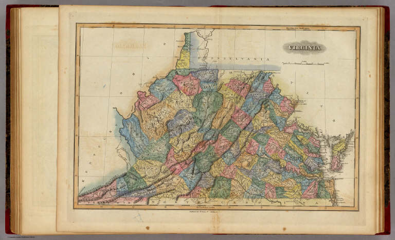
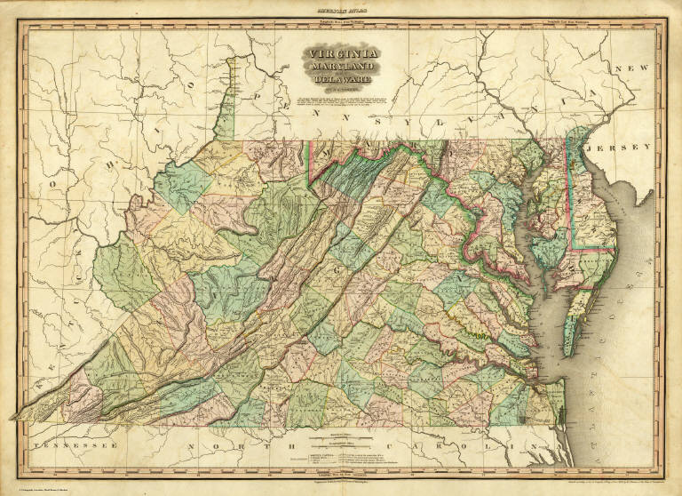
Author
Lucas, Fielding Jr.
Full Title
Virginia. Published by F. Lucas Jr. Baltimore.
List No
4584.057
Note
Full color by county.
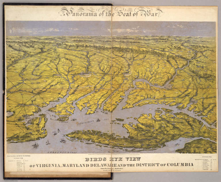
Author
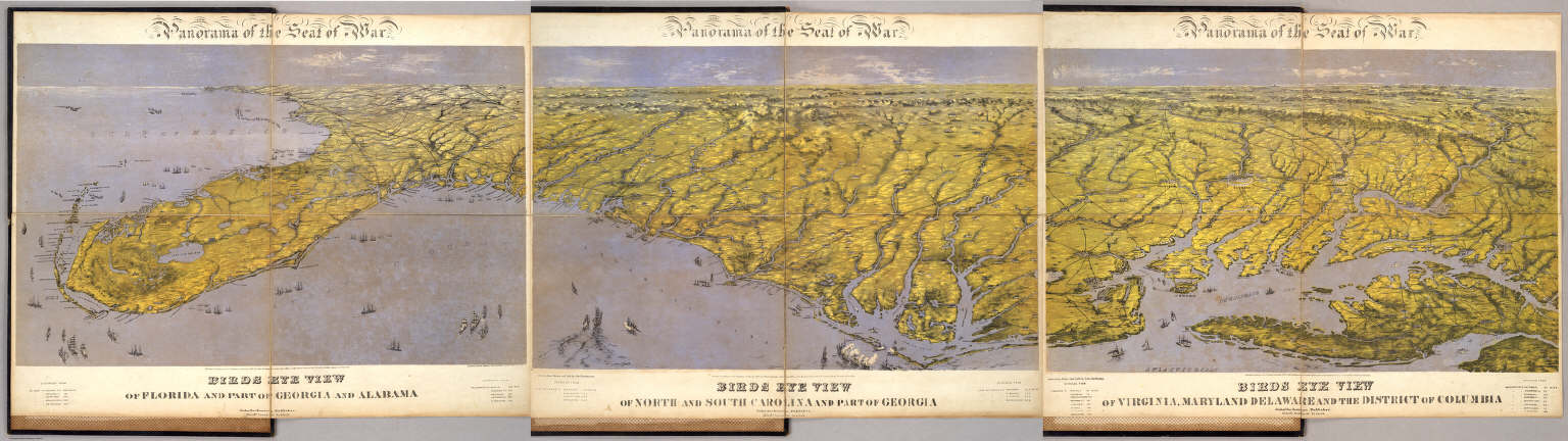
Bachmann, John
Full Title
Panorama of the Seat of War. Birds Eye View Of Virginia, Maryland Delaware And The District Of Columbia. John Bachmann, Publisher, 115 & 117 Nassau St., New York. Entered ... 1861 by John Bachmann ... New York. Drawn from Nature and Lith. by John Bachmann.
List No
0043.001
Note
1st issue; a 2nd issue shows smoke at Manassas. This view joins with the North and South Carolina view and the Florida and Georgia view to form one continuous panorama of the east coast of the Confederacy. Full color. Bound in black leather covers 38x3
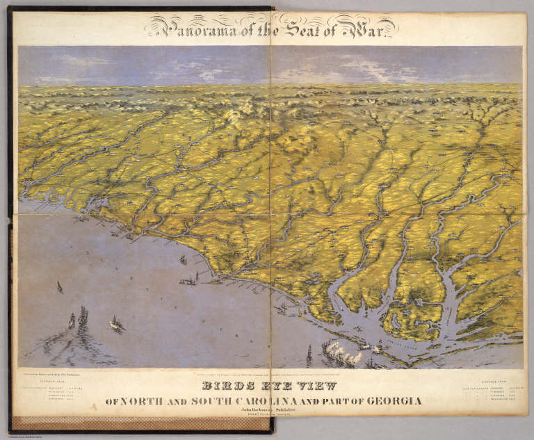
Author
Bachmann, John
Full Title
Panorama of the Seat of War. Birds Eye View Of North And South Carolina And Part Of Georgia. John Bachmann, Publisher, 115 & 117 Nassau St., New York. Entered ... 1861 by John Bachmann ... New York. Drawn from Nature and Lith. by John Bachmann.
List No
2664.001
Note
Shows shelling of Ft. Hatteras. Stephenson shows an earlier issue (304.5) that does not have Bachmann's name as publisher, nor the phrase "drawn from nature and lith. by John Bachmann." Full color. Bound in black leather covers 38x30 with "North & South Carolina, Part of Georgia. G.G.W." stamped in gold.
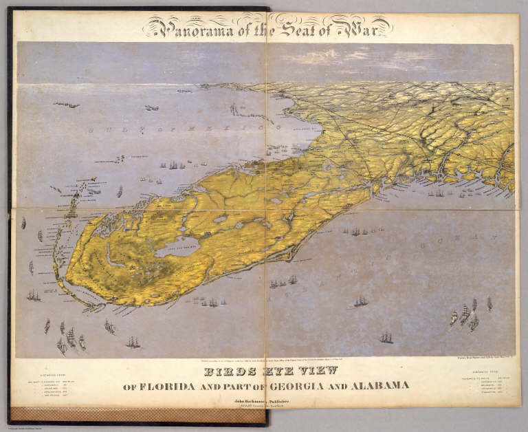
Author
Bachmann, John
Full Title
Panorama of the Seat of War. Birds Eye View Of Florida And Part Of Georgia And Alabama. John Bachmann, Publisher, 115 & 117 Nassau St., New York. Entered ... 1861 by John Bachmann ... New York. Drawn from Nature and Lith. by John Bachmann.
List No
2665.001
Note
Shows entire Florida Peninsula. See Stephenson page 15 for a general discussion of Bachmann's civil war views. In addition to the six panoramas of the seat of war, Bachmann did a view of Richmond (Stephenson 621, illustrated p271), and of the junction of the Ohio and Mississippi Rivers (Stephenson 1.5) - which may be similar to the Kentucky - Tennessee Seat of War view, at least in terms of vantage point. Full color. Bound in black leather covers 38x30 with "Florida & Part Of Georgia & Alabama. G.G.W." stamped in gold.
Author
Carey, Mathew
Full Title
(Title Page to) Carey's American Atlas: Containing Twenty Maps And One Chart ... Philadelphia: Engraved For, And Published By, Mathew Carey, No. 118, Market Street. M.DCC.XCV. [Price, Plain, Five Dollars-Coloured, Six Dollars.]
List No
2542B
Note
First atlas of America printed in America. First edition. These maps were also published in Carey's American edition of Guthrie's Geography (1795) and most of the maps say "engraved for Carey's American edition of Guthrie's improved." The maps were again used for the 1796 edition of Carey's General Atlas, unchanged except for the Tennessee map, which is titled "Tennassee State" instead of "Tennassee Government" which is the title in both the American Atlas and the Guthrie Atlas - see Wheat and Brun, and has several counties delineated in the eastern part of the state which do not show in the 1795 edition of the map. NMM 480 (American Atlas) has "Tennassee State" indicating that Carey was not consistent. This atlas was the model for John Reid's American Atlas of 1796. This copy's maps have very strong impressions. Rebound quarter leather, marbled paper covered boards.
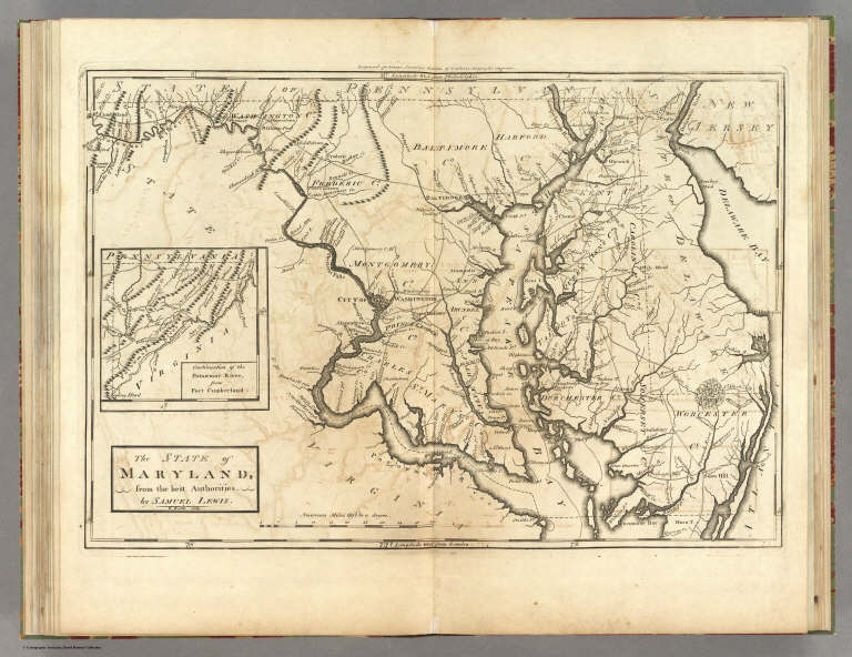
Author
[Carey, Mathew, Lewis, Samuel]
Full Title
The State of Maryland, from the best Authorities by Samuel Lewis. W. Barker sculp. Engraved for Carey's American Edition of Guthrie's Geography improved.
List No
2542.012
Note
Uncolored.
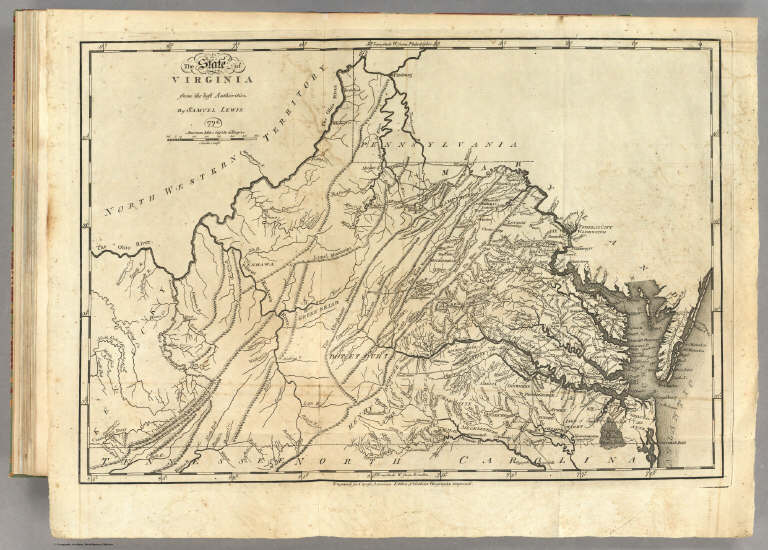
Author
[Carey, Mathew, Lewis, Samuel]
Full Title
The State of Virginia from the best Authorities, By Samuel Lewis. 1794. Smither Sculpt. Engraved for Carey's American Edition of Guthrie's Geography improved.
List No
2542.013
Note
Uncolored.
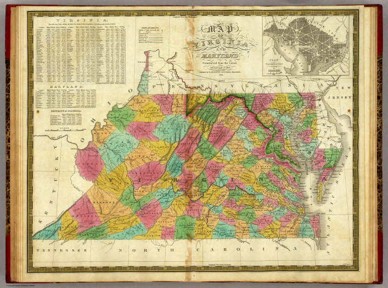
Author
Mitchell, Samuel Augustus
Full Title
Map Of Virginia And Maryland Constructed from the Latest Authorities. Published by S. Augustus Mitchell Philadelphia. 1831. J.H. Young Sc. (inset) Plan Of Washington City & Georgetown.
List No
3884.007
Note
Full color by county.
Author
[Reid, John, Winterbotham, W.]
Full Title
(Title Page to) The American Atlas; Containing The Following Maps ... New-York: Published By John Reid, Bookseller And Stationer, No. 106, Water-Street. 1796.
List No
0845B
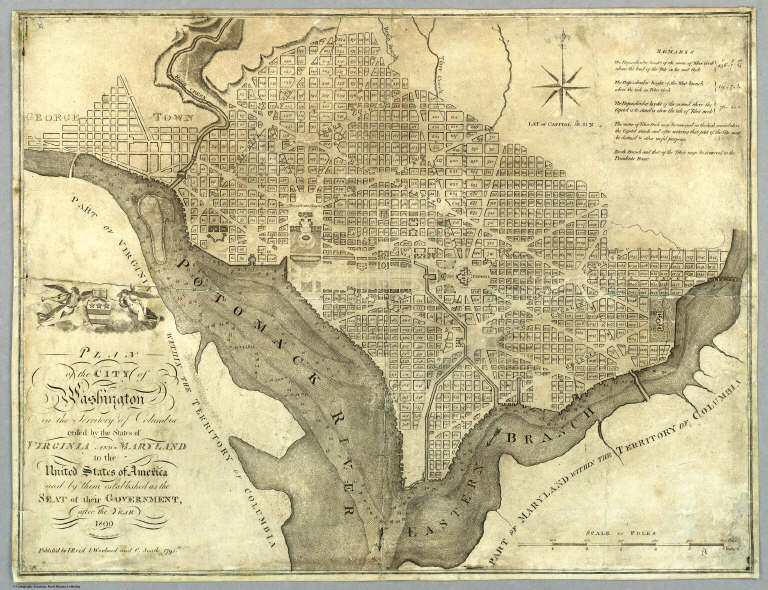
Author
Reid, John
Full Title
Plan of the City of Washington in the Territory of Columbia ceded by the States of Virginia And Maryland to the United States of America and by them established as the Seat of their Government, after the Year 1800. Rollinson sculp. N. York. Published by J. Reid L. Wayland and C. Smith 1795.
List No
5160.000
Note
State I of this map (State II lists only J. Reid as publisher). This map is taken from the first official plan of Washington published by Andrew Ellicott in 1792 (see Wheat & Brun 531). The Reid map is not an exact copy, with the title moved from the upper right to the lower left, several notes not included, and other elements moved. An exact copy of Reid's map appears in the London edition of Winterbotham's "View of the United States of America" (see our #3885). Howes gives precedence to the London edition, so it is not clear if Reid or Russell copied the Ellicott first. The Reid American Atlas index does not call for the Washington map, leading to the assumption that it was added to some copies afterwards, and speculation that it may have been sold as a separate. Scarce.
Author
Bachmann, John
Full Title
(Composite of) Panorama of the Seat of War. Birds eye view of Florida and part of Georgia and Alabama .. North and South Carolina and part of Georgia .. Virginia, Maryland, Delaware and the District of Columbia. John Bachmann, Publisher, 115 & 117 Nassau St., New York. Entered ... 1861 by John Bachmann ... New York. Drawn from Nature and Lith. by John Bachmann.
List No
5491.000
Note
Composite map image from three separate issues.
Author
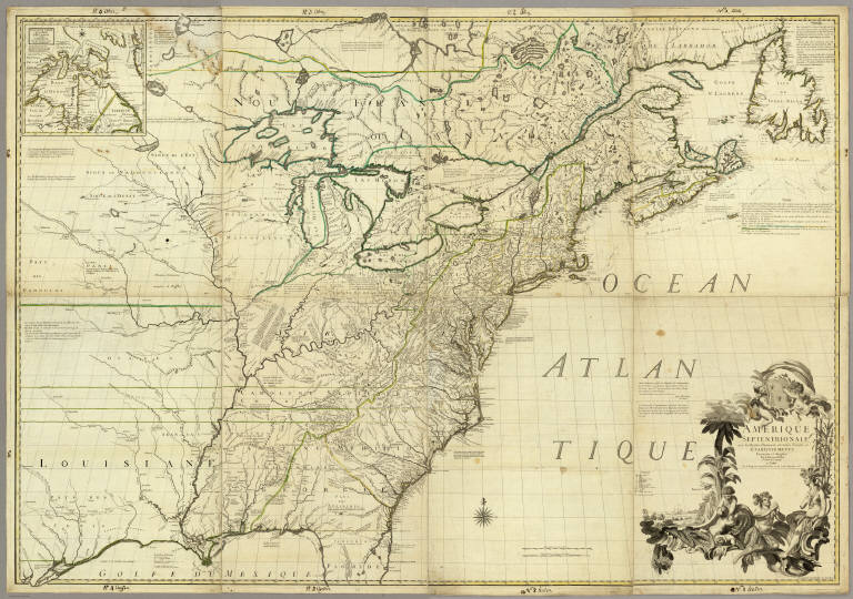
Mitchell, John
Full Title
A Map of the British and French Dominions in North America with the Roads, Distances, Limits and Extent of the Settlements.
List No
2842.000
Note
This is the second edition of this important map, dated 1755 but published in 1757, according to the British Museum. The only change from the first issue is the addition of several panels of interesting text in ocean. The original eight printed sheets of the map are here assembled in two large panels (each with four sheets) each dissected into 36 sections and mounted on linen. Uncolored, as issued. In the sixth line of the first column of the text this issue is referred to as the Second Edition One of the most important maps in American history, it went through five editions (see Stevens). We believe this second edition is scarcer than the other editions as it appears less often on the market. Compare to the first French edition of 1856 (our copy) regarding the conflicting claims of the British and French to American territory.
Author
Bradley, Abraham Junior
Full Title
(Covers to)Map of the United States, Exhibiting the Post-Roads, the situations, connexions and distances of the Post-Offices, Stage Roads, Counties & Principal Rivers By Abraham Bradley Junr. Entered ... 2nd day of June1804, by Abraham Bradley Junr. of the District of Columbia. (inset) Map Of North America.
List No
2929A
Author
Bradley, Abraham Junior
Full Title
Map of the United States, Exhibiting the Post-Roads, the situations, connexions and distances of the Post-Offices, Stage Roads, Counties & Principal Rivers By Abraham Bradley Junr. Entered ... 2nd day of June1804, by Abraham Bradley Junr. of the District of Columbia. (inset) Map Of North America. (1812)
List No
2929.001
Note
4th edition, corrected to 1812, but dated 1804. This map was originally issued in 1804. This copy is dated 1804 but is corrected for political and topographical changes to 1812. It shows Louisiana and Missouri Territory, both of which were established in 1812. There has been extensive redrawing of the Mississippi River from the junction of the Ohio north to the Wyaconda River (probably due to the public surveys in southern Illinois, evidenced by the appearance of Township and Range lines there). Numerous other changes from the 1804 edition have been made throughout the map adding new counties, towns, roads, and changed physical features, primarily in the mid and western portions. So far I have been able to identify 1804, 1806, 1809, and 1812 editions, but it is likely that other editions will be discovered. The dates are estimates based on the political changes on the maps - all editions are dated 1804 on the title. Since it was a postal map and needed to be current as to towns, road and counties, it is probable that the map was updated every few years, until a new plate was made in 1819 by Harrison (Karpinski 59, Karrow 1-1466). The 1796 edition of this map (a different engraving) was changed four times in as many years (Wheat & Brun 127-130). The 1819 edition became the official post office map in 1825, used until 1829 (Ristow). All of the 1804 to 1812 editions were originally engraved by Francis Shallus of Philadelphia. With outline color. This copy in original condition, dissected into 32 sections and mounted on linen, in original quarter leather marbled covers 27x20 with ties (remnants now) and title "Bradley's U. States" stamped in gild on the spine.
Author
[Mitchell, Samuel Augustus, Young, James H.]
Full Title
Map Of The United States By J.H. Young. Published by S. Augustus Mitchell. Entered ... Pennsylvania, October 10th, 1831 by S. Augustus Mitchell. Engraved by J.H. Young, D. Haines & F. Dankworth. (inset) A Map Of North America Including All The Recent Geographical Discoveries. (with 10 additional inset maps).
List No
2723.001
Note
1st edition, 1st wall map issued by Mitchell. This edition does not have the counties delineated and numbered. Ristow mistakenly says all editions have the townships (he means counties) numbered, but this one, the first, does not, thereby eliminating the index of counties and thus showing more of the western territory. This map predates the Traveler's Guide by 1 year, and thus is Mitchell's first "original" production, as opposed to the Finley material he reissued as the American Atlas and Pocket Maps. The case for the map has a leather label saying "Traveler's Map of the United States." Copyright date is October 10, 1831. There is no other date on the map. Ristow thinks the map was issued in early 1832, but it is not in Phillips until 1834 edition (which probably has the counties indicated by number and the 1831 copyright), so Ristow may not have seen this edition, but rather the 1834. The map is hand painted in bright full color by state (insets by county), dissected in 24 sections with green paper end sheets, mounted on linen and edged in pink silk. The covers 24x20 are half red leather marbled paper covered boards with ties and a leather label embossed with "Traveller's Map Of The United States" in gilt.
Author
Tanner, Henry S.
Full Title
(Title Page to) A New Universal Atlas Containing Maps of the various Empires, Kingdoms, States and Republics Of The World. With a special map of each of the United States, Plans of Cities &c. Comprehended in seventy sheets and forming a series of One Hundred And Seventeen Maps, Plans And Sections, By H.S. Tanner ... Philadelphia, Published By The Author. 1836. (title page by) J. Knight Sc.
List No
0977B
Note
The non American maps may be partly derived from the Dower/Teesdale General Atlas of 1831 - see P3549 & P772. North America map has states in different colors and has the following differences from the 1843 Atlas copy: San Felipe de Austin (as opposed to San Felipe in the 1843), and Sioux and Wisconsin Dists (not in the 1843 edition). Wheat mistakenly uses a post 1836 issue as an illustration in Trans Miss and calls it 1836. The Mexico map has differences from 1843 issue: Houston appears in 1843 and not in 1836, and San Felipe de Austin in 1836 is San Felipe in 1843. The Michigan map changes substantially between the 1836, the 1842, and the 1843 editions, especially the shoreline. See notes to the (1838) edition which also has a title page dated 1836. Bound in half leather, marbled paper covered boards, with "Tanner's Universal Atlas. 1836." stamped in gilt along the spine. Full color.
Author
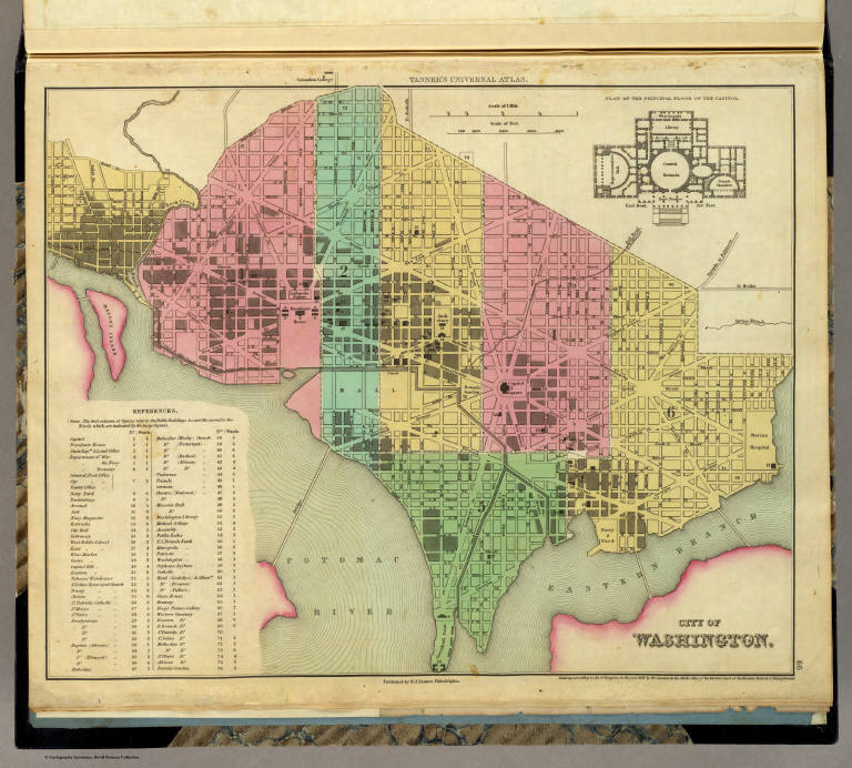
Tanner, Henry S.
Full Title
City of Washington. Published by H.S. Tanner, Philadelphia. Entered ... 1836, by H.S. Tanner ... Pennsylvania. (above neat line) Tanner's Universal Atlas.
List No
0977.067
Note
Full color by area with chart explaining public buildings and wards. Drawing of the principal plan of the Capitol included.
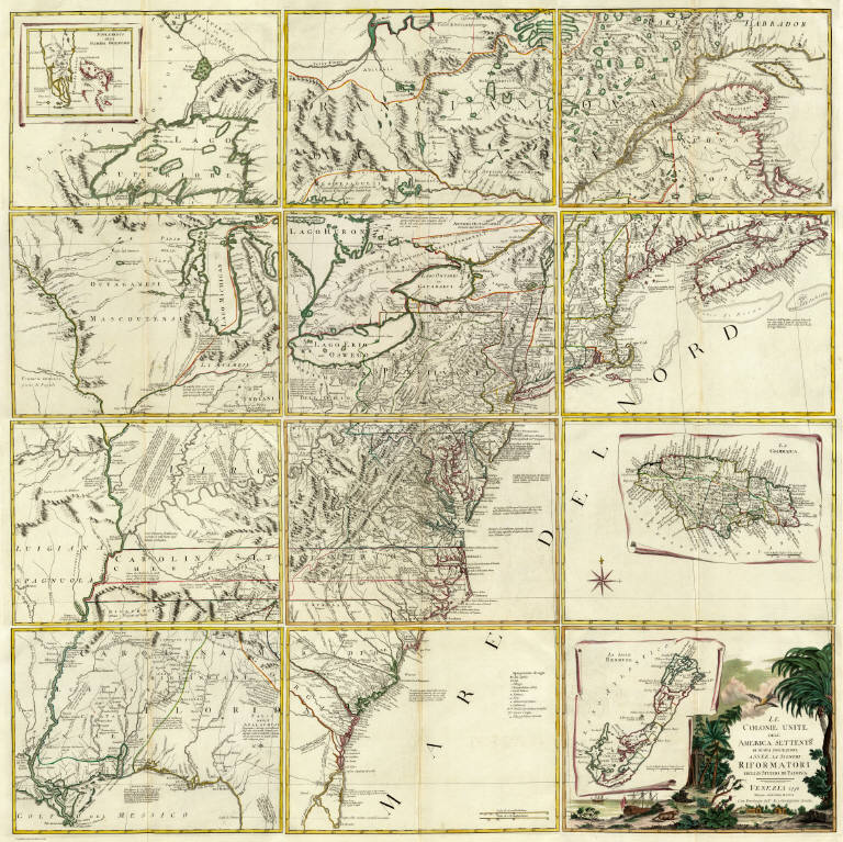
Mitchell, John ; Raynal, G.T.; Zatta, An... Title Page: Storia dell' America Settent... 1778 5007A Related Author
[Mitchell, John, Raynal, G.T., Zatta, Antonio]
Full Title
(Title Page to) Storia Dell' America Settentrionale Del Signor Abate Raynal Continuata fino al present, con Carte Geografiche rappresentanti il Teatro della Guerra Civile tra la Gran Bretagna, e le Colonie Unite. A SS. EE. Li Signori Rifoormatori Dello Studio Di Padova. In Venezia, Dalle Stampe Di Antonio Zatta Con Licenza De Superiori, E Privilegio. M. DCC. LXXVIII.
List No
5007A
Note
In addition to a two volume Italian translation of Raynal's History of North America, this book contains the first edition of Zatta's twelve sheet version of Mitchell's Map of North America, plus three other maps: Il Canada, Le Isole di Terra Nuova e Capo Breton, and La Baja D' Hudson. All of these maps appeared also in Zatta's Atlante Novissimo published from 1779-1785. A second edition of the Zatta/Mitchell maps was published in 1791 (see P651). Zatta's version of Mitchell is not an exact or complete copy: the Zatta maps do not cover the far western portions of Mitchell's map, many geographical changes are introduced, and Bermuda is depicted as well as Jamaica., neither of which are shown by Mitchell. A separate map covers Newfoundland and Cape Breton, on the same scale. Maps are hand painted with outline color. Covers are quarter leather light brown marbled paper covered boards with "Raynal. Storia Dell' America Settentrionale. 1778" stamped in gilt on the new leather spine.
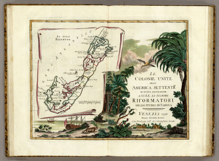
Author
[Mitchell, John, Raynal, G.T., Zatta, Antonio]
Full Title
Le Isole Bermude. (title cartouche) Le Colonie Unite dell' America Settentrle. di Nuova Projezione Ass. Ee. Li Signori Riformatori dello Studio di Padova. Venezia 1778, Presso Antonio Zatta, con Privilegio dell' Eccellentissimo Senato.
List No
5007.001
Note
In full color. Map appears on an unfurled scroll laid atop a drawing of the local flora and fauna. Large elaborate drawing surrounds the title cartouche for 12 map sheets when viewed as a composite.
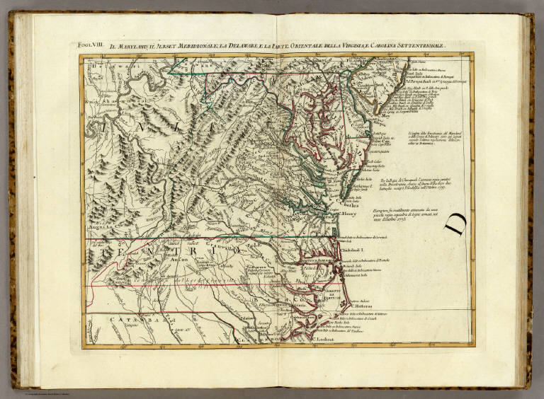
Mitchell, John ; Raynal, G.T.; Zatta, An... Il Maryland, il Jersey Meridionale, la D... 1778 5007.010 Related Author
[Mitchell, John, Raynal, G.T., Zatta, Antonio]
Full Title
Il Maryland, il Jersey Meridionale, la Delaware, e la Parte Orientale della Virginia, e Carolina Settentrionale. Fogl. VIII.
List No
5007.010
Note
In outline color.
Mitchell, John ; Raynal, G.T.; Zatta, An... Composite: Colonie Unite dell' America S... 1778 5007.016 Related Author
[Mitchell, John, Raynal, G.T., Zatta, Antonio]
Full Title
(Composite Map of) Le Colonie Unite dell' America Settentrle. di Nuova Projezione Ass. Ee. Li Signori Riformatori dello Studio di Padova. Venezia 1778, Presso Antonio Zatta, con Privilegio dell' Eccellentissimo Senato. (Fogl. I-XI and title page.)
List No
5007.016
Note
Composite of maps Fogl. I-XI and the title page which includes the map of Bermuda.
Author
[Carey, H. C., Lea, I.]
Full Title
(Title Page to) A Complete Historical, Chronological, And Geographical American Atlas, Being A Guide To The History Of North And South America, And The West Indies ... To The Year 1822. According To The Plan Of Le Sage's Atlas And Intended As A Companion To Lavoisne's Improvement Of That Celebrated Work. Philadelphia: H.C. Carey And I. Lea, Chestnut Street. 1822. (on verso) ... T.H. Palmer, Printer.
List No
0122B
Note
1st Edition; Fielding Lucas engraved most of the maps. The 1823 edition was unchanged in most copies, a few have minor map updates, and one (see our copy) has all of the 1827 edition maps while still retaining the 1823 title page and most of the text. The 1827 edition includes much new material, with all the maps and text updated, except for the Washington, D.C., and Michigan maps. A French edition by Buchon was published in 1825, an abridged London edition in 1823 (see our copies), and a German edition by C.F. Weiland in 1824-1828 (P1225, Espenhorst 1.6.3). This was the first American Atlas that was modeled on Le Sage's plan of having explanatory text surrounding the maps. The maps are beautifully drawn and colored. Lucas went on to publish his own General Atlas in 1823, using similar maps but without the text. Rebound into half leather tan paper covered boards with "American Atlas. 1822." stamped in gilt along the spine.
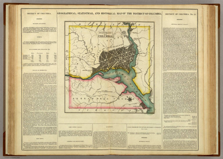
Author
[Carey, H. C., Lea, I.]
Full Title
Geographical, Historical, And Statistical Map Of The District Of Columbia. District Of Columbia. No. 21. Engraved by Young & Delleker.
List No
0122.016
Note
In full color surrounded by text.
Author
Melish, John
Full Title
(Title Page to) A Military and Topographical Atlas of the United States; Including The British Possessions & Florida ... By John Melish. Philadelphia, Published By John Melish. G. Palmer Printer 1815. (on verso) District of Pennsylvania ... fourteenth day of March ... 1815 ... John Melish ... hath deposited ... a book.
List No
2788B
Note
2nd edition. 9 large folding maps, 3 small maps. Melish adds four large maps, two of the St. Lawrence river area, one of the Creek Indian Territory, and one of New Orleans. Catalogue of Melish's works in front. Maps in outline color bound in half leather with fabric ties. "Military Atlas" imprinted on the spine.
Author
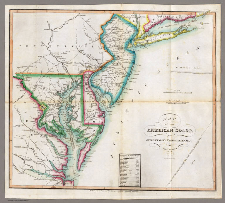
Melish, John
Full Title
Map of the American Coast, from Lynhaven Bay to Narraganset Bay, by John Melish.
List No
2788.006
Note
Fold-out map in outline color stretching from Long Island Sound to Norfolk, Virginia.
Author
Popple, Henry
Full Title
(Covers to) A Map of the British Empire in America with the French and Spanish Settlements adjacent thereto. by Henry Popple. C. Lempriere inv. & del. B Baron Sculp. To the Queen's Most Excellent Majesty This Map is most humbly Inscribed by Your Majesty's most Dutiful, most Obedient, and most Humble Servant Henry Popple. London Engrav'd by Willm. Henry Toms & R.W. Seale, 1733. (index map) ... W.H. Toms Sculp.
List No
2874A
Author
Popple, Henry
Full Title
America Septentrionalis. A Map of the British Empire in America with the French and Spanish Settlements adjacent thereto. by Henry Popple. To the Queen's Most Excellent Majesty This Map is most humbly Inscribed by Your Majesty's most Dutiful, most Obedient, and most Humble Servant Henry Popple. W.H. Toms Sculp.
List No
2874.001
Note
Index map in full color with numeric notations indicating location of the accompanying maps. With eighteen inset maps and four views (Fall of Niagara, Mexico [City], Quebec and New York). Note by Edmund Halley at the bottom verifies the accuracy of the map.
Author
Popple, Henry
Full Title
(Composite Map of) A Map of the British Empire in America with the French and Spanish Settlements adjacent thereto. by Henry Popple. C. Lempriere inv. & del. B Baron Sculp. To the Queen's Most Excellent Majesty This Map is most humbly Inscribed by Your Majesty's most Dutiful, most Obedient, and most Humble Servant Henry Popple. London Engrav'd by Willm. Henry Toms & R.W. Seale, 1733.
List No
2874.002
Note
A composite of all twenty sheets of the Popple Atlas. Sheets without color.
Author
Arrowsmith, Aaron
Full Title
A Map Of The United States Of North America Drawn from a number of Critical Researches By A. Arrowsmith, Hydrographer to H.R.H. the Prince of Wales. No. 10 Soho Square. London. Published as the Act Directs by A. Arrowsmith, No. 10 Soho Square. Jan 1st, 1796. Additions to 1802.
List No
2098.001
Note
Watermark, J. Whatman 1811, NE sheet, lower left. Comparing to 79(d), 1804, I cannot find the changes indicated by Stevens, and comparing to 79(f), which only has added "-1815" in ms, I cannot find any changes either. It could be that this copy of 79(e) is later than the one Stevens saw as indicated by the 1811 watermark. There may be a 79(e) without the 1811 watermakr that is earlier. Outline color by state. Map is in four sheets, each dissected into 18 sections. Sheets fold, each with a label pasted to the linen backing reading "Sold by W. Faden, Geographer to His Majesty and to His Royal Highness the Prince of Wales. No. 5 Charing Cross." The four map sheets lie folded between two brown card end sheets, inside their original marbled paper slip case 22x13.5 with the same paste down label.
Author
Mitchell, John
Full Title
Amerique Septentrionale avec les Routes, Distances en miles, Limites et Establissements Francois et Anglais. Par le Docteur Mitchel, Traduit de l'Anglois. A Paris, Par le Rouge Ingr. Geographe du Roy rue des Grands Augustins 1756.
List No
0510.000
Note
1st French edition, 8 sheets. Very interesting French reengraving of Mitchell's map, emphasizing their territorial claims at the expense of the British claims; in particular they add an area of "contestations" between French claims and the English claims.
Author
Robert Sayer and John Bennett (Firm)
Full Title
(Title Page to) The American Military Pocket Atlas; Being An approved Collection of Correct Maps, Both General and Particular, of The British Colonies; Especially those which now are, or probably may be The Theatre of War: Taken principally from the actual Surveys and judicious Observations of Engineers De Brahm and Romans; Cook, Jackson, and Collet; Maj. Holland, and other Officers, Employed in His Majesty's Fleets and Armies. London. Printed for R. Sayer and J. Bennet, Map and Print-Sellers (No. 53) Fleet-street.
List No
0875B
Note
This small hand atlas has six early maps, three of which are particularly important to the mapping of the American Revolution: The Seat of War in the Northern Colonies and The seat of War in the Middle British Colonies (both derived from the Evans/Pownall maps), and the Seat of War in the Southern Colonies (by Bernard Romans). Nicknamed the "Holster Atlas" because it was made for the used of British army officers. All maps in outline color, folded and bound into book with paper covered boards and quarter leather with "American Pocket Atlas" stamped in gilt on the spine.
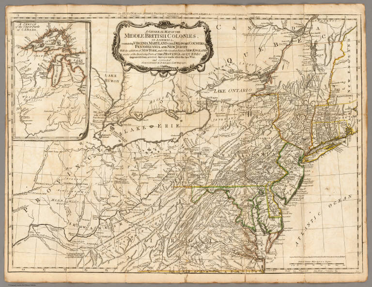
Robert Sayer and John Bennett (Firm) A General Map of the Middle British Colo... 1776 0875.004 Related Author
Robert Sayer and John Bennett (Firm)
Full Title
A General Map of the Middle British Colonies, in America. containing Virginia, Maryland, the Delaware Counties, Pennsylvania and New Jersey. With the addition of New York, and of the Greatest Part of New England, as also of the Bordering Parts of the Province of Quebec, improved from several Surveys made after the late War, and Corrected from Governor Pownall's Late Map 1776. (with) A Sketch of the Upper Parts of Canada. London: Printed for R. Sayer & J. Bennett ... 15th October 1776.
List No
0875.004
Note
In outline color. Above the map reads, "The Seat of War in the Middle British Colonies containing Virginia, Maryland, the Delaware Counties, &ca."
Author
[Hall, E.S., Lloyd, H.H., Waters & Son]
Full Title
Military Portraits. Glossary Of War Terms, Maps, Arms, Etc. (Map of) Maryland, Virginia, Chesapeake Bay, Etc., Etc. Published by H.H. Lloyd & Co., 25 Howard Street, New York. Agents wanted to sell this and many other Charts for the times. Entered ... 1861, by H.H. Lloyd & Co.
List No
5395.000
Note
A very decorative Civil War chart showing military uniforms and dress, 10 portraits of prominent Union Officers, and a map delineating battles around Washington.
Haskins, Charles; Lloyd, H.H. ; Viele, E... H.H. Lloyd & Co's Campaign Military Char... 1861 5397.000 Related Author
[Haskins, Charles, Lloyd, H.H., Viele, Egbert L.]
Full Title
H.H. Lloyd & Co's Campaign Military Charts Showing The Principal Strategic Places Of Interest. Engraved Expressly To Meet A Public Want During The Present War. Compiled From Official Data By Egbert L. Viele, Military and Civil Engineer; and Charles Haskins. Published Under The Auspices Of The American Geographical And Statistical Society. Entered ... 1861 by H.H. Lloyd & Co. H.H. Lloyd & Co's Military Charts. Sixteen Maps On One Sheet.
List No
5397.000
Note
An early Civil War map. A compilation of 16 maps on one sheets of harbors, rivers, and a general map of the U.S.
Author
Lloyd, H.H.
Full Title
The National Political Chart. Lloyd's New Political Chart, 1861. With a Map of the United States, showing the Free States, Border Slave States, Cotton States, and Territories, in Different Colors. Published at H.H. Lloyd & Co.'s Agents' General Depot for Books, Maps, and Stationery Packages, 25 Howard Street, New York. Entered ... 1861, by H.H. Lloyd & Co. ... New York.
List No
5530.000
Note
Map of the U.S. is in full color with a large red border delineating the Slave States. Numerous portraits, biographies, and statistics are included.
Author
Prang, L. & Co.
Full Title
War Telegram Marking Map. L. Prang & Co. Print Publishers, 159, Washington St. Boston ... Entered ... 1862 by L. Prang & Co. ... Massachusetts.
List No
4682.000
Note
In the "Explanations" below the map Prang states that this is "a map to mark the change of positions of the Union forces in red pencil and the rebel forces in blue, on the receipt of every telegram from the seat of war..." He goes on to say that he will furnish the necessary pencils and that "with the aid of a little soft bread" prior markings can be erased to show the latest developments. Printed in brown ink, showing the area between Richmond and Washington in good detail.
Author
[Hall, E.S., New York Herald]
Full Title
War Maps And Diagrams. Our Naval And Military Operations At A Glance. The Coast and Land Line of the Rebellious States ... The Union Blockade of the Atlantic and Gulf Coast ... The Rebel Batteries on the Mississippi ... The Forts on the Southern Sea Line. The New York Herald. New York. Saturday, November 16, 1861. (with) 17 additional maps.
List No
5472.001
Note
Map without color. It shows the coast and land line of the Southern States. Map shows positions of the Union and Rebel troops.
Author
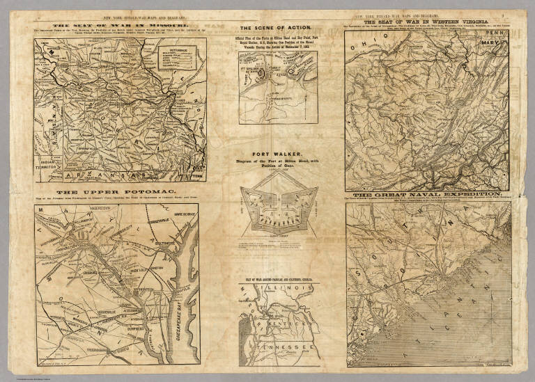
[Hall, E.S., New York Herald]
Full Title
Seven maps from the New York Herald War Maps and Diagrams. (Pages) 3 and 6. (see note field for titles).
List No
5472.003
Note
Maps without color. Each map has its own title: The Seat Of War In Missouri. The Upper Potomac. The Scene Of Action. Fort Walker. Seat Of War Around Paducah And Columbus, Georgia. The Seat Of War In Western Virginia. The Great Naval Expedition.
Author
[Hall, E.S., New York Herald]
Full Title
Map of New Orleans and Surrounding Country. (with) The Lower Potomac. New York Herald War Maps and Diagrams. (Page) 8.
List No
5472.006
Note
Maps uncolored.
Author
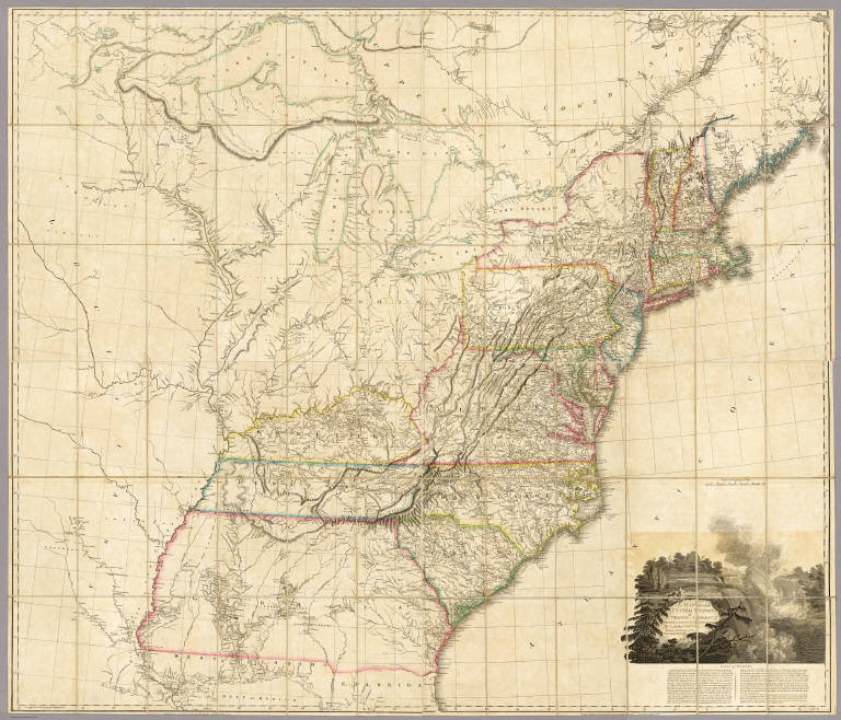
Tanner, Henry S.
Full Title
(Title Page to) A New American Atlas Containing Maps Of The Several States of the North American Union, Projected and drawn on a Uniform Scale from Documents found in the public Offices of the United States and State Governments, and other Original and Authentic Information, By Henry S. Tanner ... Philadelphia: Published By H.S. Tanner. 1823. (title page only) Writing Drawn and Engraved by Joseph Perkins. Barralet del. Humphrys sc.
List No
5388C
Note
The first edition with the earliest states of all the maps. Many believe this to be the finest atlas published in the United States in the 19th century. The text essay (included here) is a wonderful compilation of information on the contemporary maps that Tanner used as sources. Tanner updated the maps frequently over the next two decades, and issued several editions or compilations of the atlas with the title pages dated 1823 or 1825, but with some of the maps dated as late as 1833. The collation of our six issues shows that no two copies are alike and that the maps were being constantly updated; however the choice of maps for each edition reveals a somewhat haphazard approach with some of the earliest states of a particular map appearing the one of the later atlas editions. A completely revised edition was issued in 1839, with the title page and most of the maps dated 1839 (see P1382). Hand painted in outline color with a full color wash. Atlas is bound in half leather marbled paper covered boards with "Tanner's American Atlas" stamped in gilt on a front leather label.
Author
Tanner, Henry S.
Full Title
Virginia, Maryland and Delaware By H.S. Tanner. Engraved & Published by H.S. Tanner, Philadelphia. Engraved by H.S. Tanner & Assistants. Entered ... 20th day of Decr. 1820, by H.S. Tanner... Pennsylvania. American Atlas.
List No
5388.017
Note
In full color by county.
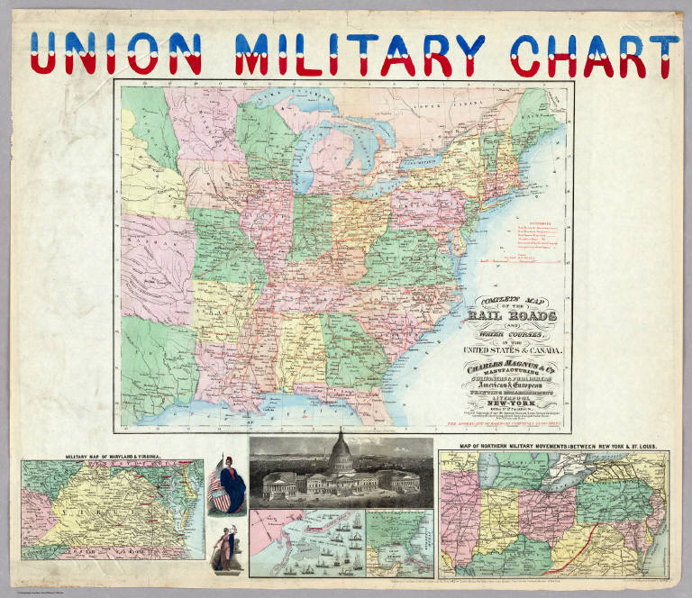
Author
Magnus, Charles
Full Title
Union Military Chart. Complete Map Of The Rail Roads And Water Courses In The United States & Canada. Charles Magnus & Co. ... Liverpool, New York Office No. 12 Frankfort St. ... Entered ... 1859 by Charles Magnus & Co. ... New York. (with) Military Map Of Maryland & Virginia. (with) Map Of Northern Military Movements: Between New York & St. Louis. Published by Chs. Magnus ... Entered ... 1861 by Charles Magnus ... New York. (with two small untitled maps: Pensacola Bay and United States).
List No
4109.000
Note
A group of five full color maps and a view of the U.S. Capital, plus two female figures. The largest map is the Complete Map of the Rail Roads..., which shows the eastern United States with all the railroads in operations and projected. This is a Civil War map in its focus, and typically Magnus in its packing together several maps and views. Another edition, not listed, adds soldiers to the left and right of the main map, illustrating Hardee's tactics (of fighting). The large map is entered in 1859, and the whole production is entered in 1861.
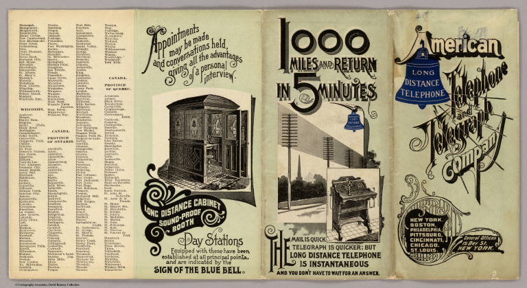
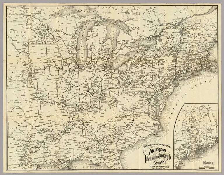
American Telephone and Telegraph Company Cover: Lines, metallic circuit connectio... 1898 3791A Related Author
American Telephone and Telegraph Company
Full Title
(Covers to) Lines And Metallic Circuit Connections. American Telephone and Telegraph Company. 15 Dey St., New York September 1898. (inset) Maine.
List No
3791A
American Telephone and Telegraph Company Lines And Metallic Circuit Connections. 1898 3791.001 Related Author
American Telephone and Telegraph Company
Full Title
Lines And Metallic Circuit Connections. American Telephone and Telegraph Company. 15 Dey St., New York September 1898. (inset) Maine.
List No
3791.001
Note
Shows the United States west to Kansas. Completed and projected telephone lines are shown. On the verso is "List of Stations Connected by Metallic Circuit Lines With the Long Distance System." On the folded cover is the statement "1000 miles and return in 5 minutes. The mail is quick, telegraph is quicker; but Long Distance Telephone is Instantaneous and you don't have to wait for an answer." Folding into self wrappers 20x9.5, with "American Telephone and Telegraph Company. Long Distance Telephone. New York. Boston, Philadelphia, Pittsburg, Cincinnati, Chicago, St. Louis. General Offices 15 Dey St. New York."
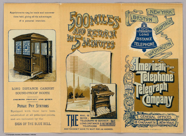
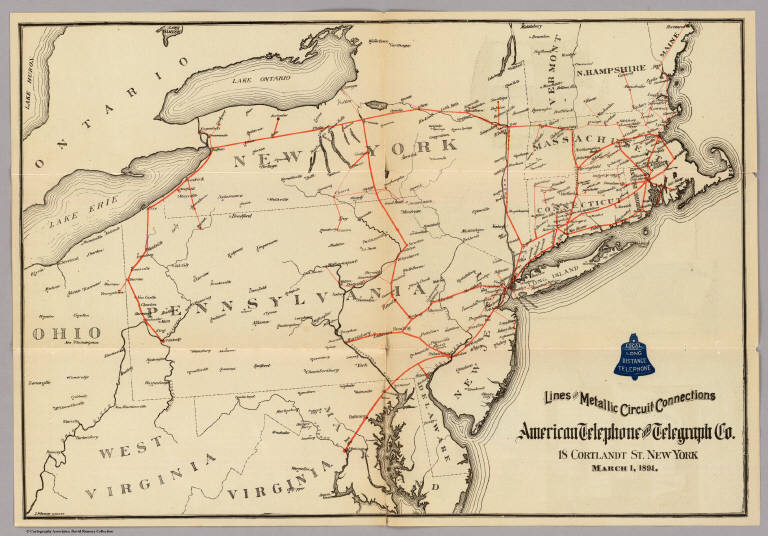
American Telephone and Telegraph Company Cover: Lines, metallic circuit connectio... 1891 5564A Related Author
American Telephone and Telegraph Company
Full Title
(Covers to) Lines and Metallic Circuit Connections. American Telephone and Telegraph Co. 18 Cortlandt St. New York. March 1, 1891.
List No
5564A
American Telephone and Telegraph Company Lines And Metallic Circuit Connections. 1891 5564.001 Related Author
American Telephone and Telegraph Company
Full Title
Lines and Metallic Circuit Connections. American Telephone and Telegraph Co. 18 Cortlandt St. New York. March 1, 1891.
List No
5564.001
Note
The map shows the communication lines in orange. On the folded cover is the statement "500 miles and return in 5 minutes. The mail is quick; telegraph is quicker; but Long Distance Telephone is Instantaneous and you don't have to wait for an answer." On the back of the map is a list of public pay stations. Folding into self wrappers 20x9.5, with "New York, Boston, Buffalo, Washington. Local and Long Distance Telephone. American Telephone and Telegraph Company. General Offices, 18 Cortlandt St. New-York. John C. Rankin Co., 34 Cortlandt St. N.Y."
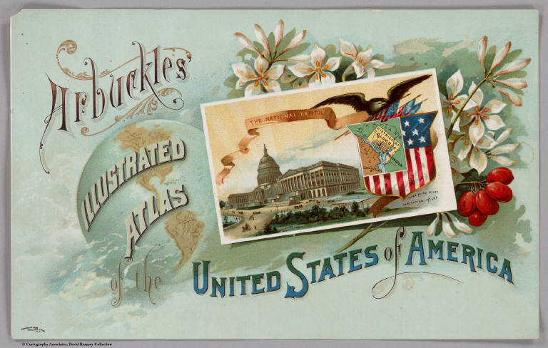
Author
Arbuckle Bros.
Full Title
(Front cover to) Arbuckles' lllustrated Atlas of the United States of America. Copyright 1889, Arbuckle Bros. N.Y.
List No
0027A
Note
The front cover features a card with a map of the District of Columbia and a picture of the capitol.
Bruff, J. Goldsborough ; Disturnell, Joh... Cover: Army map, Seat of War, Virginia. 1862 2846A Related Author
[Bruff, J. Goldsborough, Disturnell, John]
Full Title
(Covers to) Army Map Of The Seat Of War In Virginia, Showing the Battle Fields, Fortifications, Etc. on & near the Potomac River. Drawn by J.G. Bruff. Published by J. Disturnell, New York And Hudson Taylor, Washn. D.C. 1862. Entered ... 1861, by John Disturnell ... New York. Lith. of P.S. Duval & Son, Philada.
List No
2846A
Bruff, J. Goldsborough ; Disturnell, Joh... Army Map Of The Seat Of War In Virginia. 1862 2846.001 Related Author
[Bruff, J. Goldsborough, Disturnell, John]
Full Title
Army Map Of The Seat Of War In Virginia, Showing the Battle Fields, Fortifications, Etc. on & near the Potomac River. Drawn by J.G. Bruff. Published by J. Disturnell, New York And Hudson Taylor, Washn. D.C. 1862. Entered ... 1861, by John Disturnell ... New York. Lith. of P.S. Duval & Son, Philada.
List No
2846.001
Note
2nd edition, 1st was 1861. A beautiful production by Bruff, very detailed and well done. Major battles (Bull Run, etc.) near Washington are shown as well as fortifications around the capital. There is a list of 34 U.S. forts in the lower right. Map is folded into red cloth covers 15.5x11 with "Seat of War on the Potomac" stamped in gilt.
|