Author
Lucas, Fielding Jr.
Full Title
Florida. B. Welch Sc. Drawn & Published by F. Lucas Jr. Baltimore.
List No
4584.072
Note
Areas in full color with numerous Banks shown (including Great Bahama, Little Bahama, and Salt Key).
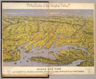
Author
Bachmann, John
Full Title
Panorama of the Seat of War. Birds Eye View Of Virginia, Maryland Delaware And The District Of Columbia. John Bachmann, Publisher, 115 & 117 Nassau St., New York. Entered ... 1861 by John Bachmann ... New York. Drawn from Nature and Lith. by John Bachmann.
List No
0043.001
Note
1st issue; a 2nd issue shows smoke at Manassas. This view joins with the North and South Carolina view and the Florida and Georgia view to form one continuous panorama of the east coast of the Confederacy. Full color. Bound in black leather covers 38x3
Author
Bachmann, John
Full Title
Panorama of the Seat of War. Birds Eye View Of North And South Carolina And Part Of Georgia. John Bachmann, Publisher, 115 & 117 Nassau St., New York. Entered ... 1861 by John Bachmann ... New York. Drawn from Nature and Lith. by John Bachmann.
List No
2664.001
Note
Shows shelling of Ft. Hatteras. Stephenson shows an earlier issue (304.5) that does not have Bachmann's name as publisher, nor the phrase "drawn from nature and lith. by John Bachmann." Full color. Bound in black leather covers 38x30 with "North & South Carolina, Part of Georgia. G.G.W." stamped in gold.
Author
Bachmann, John
Full Title
Panorama of the Seat of War. Birds Eye View Of Florida And Part Of Georgia And Alabama. John Bachmann, Publisher, 115 & 117 Nassau St., New York. Entered ... 1861 by John Bachmann ... New York. Drawn from Nature and Lith. by John Bachmann.
List No
2665.001
Note
Shows entire Florida Peninsula. See Stephenson page 15 for a general discussion of Bachmann's civil war views. In addition to the six panoramas of the seat of war, Bachmann did a view of Richmond (Stephenson 621, illustrated p271), and of the junction of the Ohio and Mississippi Rivers (Stephenson 1.5) - which may be similar to the Kentucky - Tennessee Seat of War view, at least in terms of vantage point. Full color. Bound in black leather covers 38x30 with "Florida & Part Of Georgia & Alabama. G.G.W." stamped in gold.
Author
Carey, Mathew
Full Title
(Title Page to) Carey's American Atlas: Containing Twenty Maps And One Chart ... Philadelphia: Engraved For, And Published By, Mathew Carey, No. 118, Market Street. M.DCC.XCV. [Price, Plain, Five Dollars-Coloured, Six Dollars.]
List No
2542B
Note
First atlas of America printed in America. First edition. These maps were also published in Carey's American edition of Guthrie's Geography (1795) and most of the maps say "engraved for Carey's American edition of Guthrie's improved." The maps were again used for the 1796 edition of Carey's General Atlas, unchanged except for the Tennessee map, which is titled "Tennassee State" instead of "Tennassee Government" which is the title in both the American Atlas and the Guthrie Atlas - see Wheat and Brun, and has several counties delineated in the eastern part of the state which do not show in the 1795 edition of the map. NMM 480 (American Atlas) has "Tennassee State" indicating that Carey was not consistent. This atlas was the model for John Reid's American Atlas of 1796. This copy's maps have very strong impressions. Rebound quarter leather, marbled paper covered boards.
Author
Carey, Mathew
Full Title
A Chart of the West Indies, From the latest Marine Journals and Surveys. W. Barker sculp. Philada. Engraved for Carey's American Edition of Guthrie's Geography improved.
List No
2542.021
Note
Uncolored.
Author
Mitchell, Samuel Augustus
Full Title
Map Of Florida according to the Latest Authorities. Published by S. Augustus Mitchell Philadelphia. 1831. (inset below map) Comparative Elevation of the Principal Mountains Cities &c. in North & South America.
List No
3884.013
Note
Full color by county.
Author
[Reid, John, Winterbotham, W.]
Full Title
(Title Page to) The American Atlas; Containing The Following Maps ... New-York: Published By John Reid, Bookseller And Stationer, No. 106, Water-Street. 1796.
List No
0845B
Author
[Reid, John, Winterbotham, W.]
Full Title
An Accurate Map of the West Indies with the Adjacent Coast of America. 1796. D. Martin Sculpt. Publish'd by J. Reid New York.
List No
0845.020
Note
Uncolored.
Author
Bachmann, John
Full Title
(Composite of) Panorama of the Seat of War. Birds eye view of Florida and part of Georgia and Alabama .. North and South Carolina and part of Georgia .. Virginia, Maryland, Delaware and the District of Columbia. John Bachmann, Publisher, 115 & 117 Nassau St., New York. Entered ... 1861 by John Bachmann ... New York. Drawn from Nature and Lith. by John Bachmann.
List No
5491.000
Note
Composite map image from three separate issues.
Author
Mitchell, John
Full Title
A Map of the British and French Dominions in North America with the Roads, Distances, Limits and Extent of the Settlements.
List No
2842.000
Note
This is the second edition of this important map, dated 1755 but published in 1757, according to the British Museum. The only change from the first issue is the addition of several panels of interesting text in ocean. The original eight printed sheets of the map are here assembled in two large panels (each with four sheets) each dissected into 36 sections and mounted on linen. Uncolored, as issued. In the sixth line of the first column of the text this issue is referred to as the Second Edition One of the most important maps in American history, it went through five editions (see Stevens). We believe this second edition is scarcer than the other editions as it appears less often on the market. Compare to the first French edition of 1856 (our copy) regarding the conflicting claims of the British and French to American territory.
Author
Melish, John
Full Title
Map of the United States with the contiguous British & Spanish Possessions Compiled from the latest & best Authorities By John Melish. Engraved by J. Vallance & H.S. Tanner. Entered ... 6th day of June 1816. Published by John Melish Philadelphia. (inset) West Indies.
List No
5168.001
Note
With insets of the West Indies and a Statistical Table. This map has the distinction of being the first large scale detailed map made in the U.S. that showed the entire country from the Atlantic to the Pacific. This copy is an early state of the first edition -this is Martin's third state of the first edition and Ristow's fourth state (Ristow discovered a town and trail added in Ohio - Adelphi - making for a sub state of Martin's third state). The first state was an incomplete proof copy, making this the second/third state of the completed copy. The differences between this and the first complete state are small: Mansfield, Wooster, and Adelphi (and a trail from Adelphi to Athens and Chillicothe) added in Ohio, and "Vevay or" added before "Swiss Vineyards" in southeastern Indiana. Martin and Ristow identify seven states of the 1816 edition. Melish published new editions in 1818 (five states), 1819 (two states), 1820 (eight states), 1822 (two states), and 1823 (one state) for a total of twenty five different issues. Notwithstanding the many issues, the map has become extremely rare. A book accompanied the map (though issued separately) titled "A Geographical Description of the United States..." (see our #2424). Outline color by state or territory. This copy is dissected into 40 sections, backed with linen, and edged in brown cloth. It folds with marbled end sheets into new blue cloth folding boards and slip case 24.5x16.5 with leather label on spine reading "Melish. Map Of The United States. 1816" in gold.
Author
[Johnston, Alexander Keith, 1804-1871, Rogers, Henry Darwin]
Full Title
(Title Page to) Atlas Of The United States Of North America, Canada, New Brunswick, Nova Scotia, Newfoundland, Mexico, Central America, Cuba, And Jamaica. On A Uniform Scale. From The Most Recent State Documents, Marine Surveys, And Unpublished Materials. With Plans Of The Principal Cities And Sea-Ports, And An Introductory Essay On The Physical Geography, Products, And Resources Of North America. By Professor Henry Darwin Rogers, Of Boston, U.S., And A. Keith Johnston, F.R.S.E., F.R.G.S., F.G.S., Geographer To The Queen. London: Edward Stanford, 6, Charing Cross, S.W. [The Authors Reserve The Right Of Translation.] (on verso) Entered at Stationers' Hall, London ... 1857 by H.D. Rogers ... Massachusetts.
List No
3825B
Author
[Johnston, Alexander Keith, 1804-1871, Rogers, Henry Darwin]
Full Title
States Of South Carolina, Georgia, Alabama, And Florida. By Prof. H.D. Rogers & A. Keith Johnston, F.R.S.E. Entered in Sta. Hall. London ... & according to an act of Congress ... 1857, by H.D. Rogers ... Massachusetts. London, John Murray, Albemarle Street, Edinburgh, W. & A.K. Johnston. Engraved by W. & A.K. Johnston, Edinburgh.
List No
3825.016
Note
States and counties shown in outline printed color. Bahamas shown off the Florida coast.
Author
Andrews, A.H. & Co.
Full Title
Andrews Eight Inch Terrestrial Globe with the latest discoveries and Oceanic currents. A.H. Andrews & Co. Chicago, Ill.
List No
5517.000
Note
This eight inch globe is shown in full color with the continental United States shown separately and Alaska named as such. With a three -footed base and a horizon ring that includes the Zodiac signs and a calendar. Total height of base and globe is 15 inches. Date is estimated from Warner.
Author
Finley, Anthony
Full Title
Florida. 1831. Published by A. Finley Philadelphia. J.H. Young Sc. (inset) Plan Of Tallahassee. (inset) Plan Of Pensacola.
List No
0285.031
Note
Full color by county.
Author
Tanner, Henry S.
Full Title
Florida. (with) three inset maps: Pensacola, Tallahassee, Harbour of St. Augustine. Entered ... 1833 by H.S. Tanner ... Pennsylvania. Published by H.S. Tanner Philadelphia. (above neat line) Tanner's Universal Atlas.
List No
0977.018
Note
In full color by county or area with water route distances charted.
Author
[Mitchell, John, Raynal, G.T., Zatta, Antonio]
Full Title
(Title Page to) Storia Dell' America Settentrionale Del Signor Abate Raynal Continuata fino al present, con Carte Geografiche rappresentanti il Teatro della Guerra Civile tra la Gran Bretagna, e le Colonie Unite. A SS. EE. Li Signori Rifoormatori Dello Studio Di Padova. In Venezia, Dalle Stampe Di Antonio Zatta Con Licenza De Superiori, E Privilegio. M. DCC. LXXVIII.
List No
5007A
Note
In addition to a two volume Italian translation of Raynal's History of North America, this book contains the first edition of Zatta's twelve sheet version of Mitchell's Map of North America, plus three other maps: Il Canada, Le Isole di Terra Nuova e Capo Breton, and La Baja D' Hudson. All of these maps appeared also in Zatta's Atlante Novissimo published from 1779-1785. A second edition of the Zatta/Mitchell maps was published in 1791 (see P651). Zatta's version of Mitchell is not an exact or complete copy: the Zatta maps do not cover the far western portions of Mitchell's map, many geographical changes are introduced, and Bermuda is depicted as well as Jamaica., neither of which are shown by Mitchell. A separate map covers Newfoundland and Cape Breton, on the same scale. Maps are hand painted with outline color. Covers are quarter leather light brown marbled paper covered boards with "Raynal. Storia Dell' America Settentrionale. 1778" stamped in gilt on the new leather spine.
Author
[Mitchell, John, Raynal, G.T., Zatta, Antonio]
Full Title
Le Isole Bermude. (title cartouche) Le Colonie Unite dell' America Settentrle. di Nuova Projezione Ass. Ee. Li Signori Riformatori dello Studio di Padova. Venezia 1778, Presso Antonio Zatta, con Privilegio dell' Eccellentissimo Senato.
List No
5007.001
Note
In full color. Map appears on an unfurled scroll laid atop a drawing of the local flora and fauna. Large elaborate drawing surrounds the title cartouche for 12 map sheets when viewed as a composite.
Author
[Mitchell, John, Raynal, G.T., Zatta, Antonio]
Full Title
(Composite Map of) Le Colonie Unite dell' America Settentrle. di Nuova Projezione Ass. Ee. Li Signori Riformatori dello Studio di Padova. Venezia 1778, Presso Antonio Zatta, con Privilegio dell' Eccellentissimo Senato. (Fogl. I-XI and title page.)
List No
5007.016
Note
Composite of maps Fogl. I-XI and the title page which includes the map of Bermuda.
Author
[Carey, H. C., Lea, I.]
Full Title
Geographical, Historical, And Statistical Map Of Florida. Florida. No. 37. Drawn by F. Lucas Jr. Engraved by Young & Delleker.
List No
0122.032
Note
In full color by region surrounded by text.
Author
Melish, John
Full Title
(Title Page to) A Military and Topographical Atlas of the United States; Including The British Possessions & Florida ... By John Melish. Philadelphia, Published By John Melish. G. Palmer Printer 1815. (on verso) District of Pennsylvania ... fourteenth day of March ... 1815 ... John Melish ... hath deposited ... a book.
List No
2788B
Note
2nd edition. 9 large folding maps, 3 small maps. Melish adds four large maps, two of the St. Lawrence river area, one of the Creek Indian Territory, and one of New Orleans. Catalogue of Melish's works in front. Maps in outline color bound in half leather with fabric ties. "Military Atlas" imprinted on the spine.
Author
Melish, John
Full Title
Southern Section of the United States including Florida &c. by John Melish. 1816. Entered ... by John Melish ... 1 March 1813. Improved nth. June 1816.
List No
2788.005
Note
Large fold-out map in outline color. A small inset map of the Bermudas Isles is included. A statistical chart is included showing population and state area.
Author
Popple, Henry
Full Title
America Septentrionalis. A Map of the British Empire in America with the French and Spanish Settlements adjacent thereto. by Henry Popple. To the Queen's Most Excellent Majesty This Map is most humbly Inscribed by Your Majesty's most Dutiful, most Obedient, and most Humble Servant Henry Popple. W.H. Toms Sculp.
List No
2874.001
Note
Index map in full color with numeric notations indicating location of the accompanying maps. With eighteen inset maps and four views (Fall of Niagara, Mexico [City], Quebec and New York). Note by Edmund Halley at the bottom verifies the accuracy of the map.
Author
Popple, Henry
Full Title
(Composite Map of) A Map of the British Empire in America with the French and Spanish Settlements adjacent thereto. by Henry Popple. C. Lempriere inv. & del. B Baron Sculp. To the Queen's Most Excellent Majesty This Map is most humbly Inscribed by Your Majesty's most Dutiful, most Obedient, and most Humble Servant Henry Popple. London Engrav'd by Willm. Henry Toms & R.W. Seale, 1733.
List No
2874.002
Note
A composite of all twenty sheets of the Popple Atlas. Sheets without color.
Author
Arrowsmith, Aaron
Full Title
A Map Exhibiting all the New Discoveries in the Interior Parts of North America Inscribed by Permission To the Honorable Governor And Company Of Adventurers Of England Trading Into Hudson Bay In testimony of their liberal Communications To their most Obedient and very Humble Servant, A. Arrowsmith, Hydrographer to H.R.H. the Prince of Wales. No. 10 Soho Square, January 1st 1795. Additions to 1811. Additions to 1814. London: Published Jan. 1, 1795 by A. Arrowsmith No. 10 Soho Square. Additions to 1802 ...
List No
0032.001
Note
This issue incorporates the Lewis and Clark discoveries (and other discoveries) and remaps the entire continent west of the Mississippi. The changes between this and the last edition (1811) are monumental. This copy is from the collection of Sir Charles Broke (or Brooke, subsequently Vere). Broke was in Lower Canada with his regiment, the 5th (Northumberland) Regiment of Foot, which was at the battle of Plattsburg in 1814. Later, he was with the Army of Occupation in France, receiving the Waterloo medal despite arriving from Canada too late for the battle (from Manasek). Without color. Dissected into 40 sections and mounted on linen. Folds into a new gray cloth covered box case 29x22x7 with "North America A. Arrowsmith 1814" stamped on the spine in gold.
Author
Morse, Jedidiah
Full Title
(Title Page to) The American Geography; or, A View of the Present Situation of the United States of America ... Illustrated with two Sheet Maps-One of the Southern, the other of the Northern States, neatly and elegantly engraved, and more correct than any that have hitherto been published ... By Jedidiah Morse. Elizabeth Town: Printed by Shepard Kollock, for the Author. M,DCC,LXXXIX.
List No
2894A
Note
The first American Geography. Revised from the school text "Geography Made Easy", published in 1784. Governor William Livingston of New Jersey contributed to the text, and Morse in return dedicated the book to him (Felcone). The two maps were engraved by Amos Doolittle who compiled the map of the northern states, while Joseph Purcell compiled the southern states map. Includes the errata leaf and the tipped in leaf of corrections at the end. Bound in full leather with "Morse's Geography" in gilt on spine.
Author
Morse, Jedidiah
Full Title
A Map of the States of Virginia, North Carolina, South Carolina and Georgia Comprehending the Spanish Provinces of East and West Florida Exhibiting the boundaries as fixed by the late Treaty of Peace between the United States and the Spanish Dominions. Compiled from late Surveys and Observations by Joseph Purcell. Engraved for Morse's Geography by Amos Doolittle at New Haven, 1788.
List No
2894.001
Note
Map shows the boundaries between each state, the United States and Spanish Dominions, and each Indian Nation. Without color.
Author
Arrowsmith, Aaron
Full Title
Chart Of The West Indies And Spanish Dominions In North America. By A. Arrowsmith, 1803. Jones Smith & Co. sc. Beaufort Buildgs. Strand. London Published June 1st 1803 by A. Arrowsmith No. 24 Rathbone Place. To Admiral John Willett Payne, A distinguished Native of the West Indies ... This Chart is respectfully Dedicated by his most obedient Servt. A. Arrowsmith.
List No
4121.000
Note
The first edition, including Mexico to the Pacific, and with the dedication to Admiral John Willett Payne. In four sheets. Countries are outlined in color. The 1810 second and later editions only extend to the east coast of Mexico, presumably because Arrowsmith published his large map of Mexico in 1810. In its coverage of Mexico and Central America, this map is the largest scale and most accurate map of those areas published to date, preceding Pike's and Humboldt's maps by several years. It seems odd that Humboldt would criticize Arrowsmith for copying his map of New Spain, when Arrowsmith produced his own map (this West Indies Map) which included substantial portions of Mexico several years before Humboldt's map was issued. There are many differences between this map's rendering of Mexico and the 1810 Map of Mexico - the later map has more and better detail, but the earlier rendition is still impressive. Stevens and Tree only list two editions, 1803 and 1810, but Phillips lists an 1811 (P-Maps) and an 1816 (atlases). There probably were others.
Author
Arrowsmith, Aaron
Full Title
A Map Exhibiting all the New Discoveries in the Interior Parts of North America, Inscribed by Permission To the Honorable Governor and Company of Adventurers of England Trading into Hudsons Bay. In testimony of their liberal Communications. To Their most Obedient and very Humble Servant, A. Arrowsmith. Hydrographer to H.R.H. the Prince of Wales. No. 10 Soho Square. January 1st, 1795. Additions to 1811. Puke Sc.
List No
4189.000
Note
This issue is the seventh (Heckrotte) and makes changes to the Canadian waterways, when compared to the 1802 editions. The American West has been largely unchanged since the first issue of 1795. In the next issue (1814) there are massive changes in the American West. Map in light outline color.
Author
Robert Sayer and John Bennett (Firm)
Full Title
(Title Page to) The American Military Pocket Atlas; Being An approved Collection of Correct Maps, Both General and Particular, of The British Colonies; Especially those which now are, or probably may be The Theatre of War: Taken principally from the actual Surveys and judicious Observations of Engineers De Brahm and Romans; Cook, Jackson, and Collet; Maj. Holland, and other Officers, Employed in His Majesty's Fleets and Armies. London. Printed for R. Sayer and J. Bennet, Map and Print-Sellers (No. 53) Fleet-street.
List No
0875B
Note
This small hand atlas has six early maps, three of which are particularly important to the mapping of the American Revolution: The Seat of War in the Northern Colonies and The seat of War in the Middle British Colonies (both derived from the Evans/Pownall maps), and the Seat of War in the Southern Colonies (by Bernard Romans). Nicknamed the "Holster Atlas" because it was made for the used of British army officers. All maps in outline color, folded and bound into book with paper covered boards and quarter leather with "American Pocket Atlas" stamped in gilt on the spine.
Author
Robert Sayer and John Bennett (Firm)
Full Title
A General Map of the Southern British Colonies, in America. containing North and South Carolina, Georgia, East and West Florida, with the Neighbouring Indian Countries. From the Modern Surveys of Engineer de Brahm, Capt. Collet, Mouzon & Others; and from the Large Hydrographical Survey of the Coasts of East and West Florida. By B. Romans, 1776. (with) Plan of Charleston and ... St. Augustine. London: Printed for R. Sayer & J. Bennett ... 15th Octr. 1776.
List No
0875.005
Note
In outline color. Above the map reads, "The Seat of War in the Southern British Colonies comprehending North and South Carolina, Georgia, East and West Florida, &ca."
Author
Lloyd, J. T.
Full Title
Lloyd's Map Of The Southern States Showing all the Railroads, their Stations & Distances, Also The Counties, Towns, Villages, Harbors, Rivers And Forts. Compiled from the latest Government and other reliable Sources. 1861. New York, J.T. Lloyd Publisher 164 Broadway. London " 156 Cheapside. Entered ... 1861, by J.T. Lloyd ... New York.
List No
3128.001
Note
Map in full color by state.
Author
Tanner, Henry S.
Full Title
(Title Page to) A New American Atlas Containing Maps Of The Several States of the North American Union, Projected and drawn on a Uniform Scale from Documents found in the public Offices of the United States and State Governments, and other Original and Authentic Information, By Henry S. Tanner ... Philadelphia: Published By H.S. Tanner. 1823. (title page only) Writing Drawn and Engraved by Joseph Perkins. Barralet del. Humphrys sc.
List No
5388C
Note
The first edition with the earliest states of all the maps. Many believe this to be the finest atlas published in the United States in the 19th century. The text essay (included here) is a wonderful compilation of information on the contemporary maps that Tanner used as sources. Tanner updated the maps frequently over the next two decades, and issued several editions or compilations of the atlas with the title pages dated 1823 or 1825, but with some of the maps dated as late as 1833. The collation of our six issues shows that no two copies are alike and that the maps were being constantly updated; however the choice of maps for each edition reveals a somewhat haphazard approach with some of the earliest states of a particular map appearing the one of the later atlas editions. A completely revised edition was issued in 1839, with the title page and most of the maps dated 1839 (see P1382). Hand painted in outline color with a full color wash. Atlas is bound in half leather marbled paper covered boards with "Tanner's American Atlas" stamped in gilt on a front leather label.
Author
Tanner, Henry S.
Full Title
Map of Florida By H.S. Tanner. (with) West Part of Florida. Published by H.S. Tanner, Philadelphia. Engraved by H.S. Tanner & Assistants. Entered ... 20th day of August 1823, by H.S. Tanner... Pennsylvania. American Atlas.
List No
5388.024
Note
In full color.
Author
Arbuckle Bros.
Full Title
Florida, Virginia, Indiana, Rhode Island. Copyright 1889 Arbuckle Bros. N.Y.
List No
0027.004
Note
Sheet with maps of four states in full color. Florida is noted for its oranges and Rhode Island (called "Little Rhody") for its sewing thread. Each card measures 7.5 x 12.5 cm.
Author
[Asher & Company, Russell, Benjamin B.]
Full Title
(Covers to) The Historical War Map. Asher & Co. Entered ... 1862, by Asher & Co. ... Indiana. E.R. Jewett & Co. Engravers, Buffalo, N.Y.
List No
3423A
Author
[Asher & Company, Russell, Benjamin B.]
Full Title
The Historical War Map. Asher & Co. Entered ... 1862, by Asher & Co. ... Indiana. E.R. Jewett & Co. Engravers, Buffalo, N.Y.
List No
3423.001
Note
Eliminates text on map, adds text titled "Rebellion Record" in 24 pages, 4 small maps. Last battle listed in text is August 9, 1862. The map is the same as the earlier Asher map, but adds battles at Vicksburg and Baton Rouge. Has statistics of the Southern States below the map. Map has printed outline color by state; folded into green card board covers 13.5x8.5 printed with "The Historical War Map. Benj. B. Russell, No. 515 Washington Street, Boston."
Author
Hood, Washington
Full Title
Map Of The Seat Of War In Florida. Compiled By Order Of The Hon. Joel R. Poinsett, Secretary Of War, under the Direction of Col J.J. Abert U.S. Topt. Engineer, from the reconnoissances of the Officers of the U.S. Army, by Wash: Hood. Bureau of U.S. Topographical Engineers Washington City 1838. W.J. Stone Sc. Washn. City.
List No
2209.000
Note
Precursor of MacKay/Blake map of 1839. A very detailed map. A comparison of this with the MacKay/Blake map does not show significant differences, except in the north. Taylor/MacKay do not mention Hood's map as a source. Map is without color.
Author
Burr, David H., 1803-1875
Full Title
Map of Florida Exhibiting the Post Offices, Post Roads, Canals, Rail Roads, &c. By David H. Burr. (Late Topographer to the Post Office.) Geographer to the House of Representatives of the U.S. John Arrowsmith. (with) inset map of Florida panhandle. Entered ... July 10th, 1839, by David H. Burr ... District of Columbia.
List No
0104.008
Note
In full color by county. Postal routes by coach, stage, sulkey, cross, rail roads and canals shown. In 8 sections mounted on linen. Label on back states "No. 8. Florida."
Author
Colton, G.W.
Full Title
Florida. (with) Plan Of The Florida Keys. Published By J.H. Colton & Co. No. 172 William St. New York. Entered ... 1855 by J.H. Colton & Co. ... New York. No. 30.
List No
0149.036
Note
In full color by county.
Author
Morse, Jedidiah
Full Title
A Map of the States of Virginia, North Carolina, South Carolina, and Georgia; Comprehending the Spanish Provinces of East and West Florida: Exhibiting the Boundaries as fixed by the late Treaty of Peace between the United States and the Spanish Dominions. Compiled from late Surveys & Observations by Joseph Purcell. W. Harrison Senr. & Junr. sc. Engraved for Morse's Geography. Publish'd by John Stockdale Jany. 25th 1792.
List No
0632.014
Note
Map shows the boundaries between the United States and the Spanish Dominions, the individual states, and the territories claimed by the Indian nations. Map without color.
Author
Drew, Columbus
Full Title
(Covers to) Drew's New Map Of The State Of Florida Showing the Progress of the U.S. Surveys, the Completed & Projected Railroads, The Different Railroad Stations And Growing Railroad Towns, The New Towns on the Rivers and interior, and the New Counties, up to the Year 1870. Published by C. Drew, Bookseller & Stationer, Jacksonville, Fla. Copy right secured according to law. Engraved & printed by Julius Bien, N.Y.
List No
5190A
Author
Drew, Columbus
Full Title
Drew's New Map Of The State Of Florida Showing the Progress of the U.S. Surveys, the Completed & Projected Railroads, The Different Railroad Stations And Growing Railroad Towns, The New Towns on the Rivers and interior, and the New Counties, up to the Year 1870. Published by C. Drew, Bookseller & Stationer, Jacksonville, Fla. Copy right secured according to law. Engraved & printed by Julius Bien, N.Y.
List No
5190.001
Note
This is the earliest issue of this map that we have seen, earlier than any listed in Phillips or Fitzgerald. Compared to our 1876 edition (see #5040) there is far less railroad development shown on the map and the railroads are not listed to the right of the Florida Peninsula, as they are on the 1876 issue. Julius Bien is credited as engraver and printer, which is removed on the 1876 edition. There is no copyright notice. Drew's map is probably the only pocket map of Florida published in Florida in the 19th century. Not much is known about Drew - he is listed on the map as "Bookseller & Stationer" in Jacksonville. Full color by county. Map is folded into stamped dark brown cloth covers 15x9.5 with "Drew's New Map Of Florida" in gilt.
Author
Humboldt, Alexander von, 1769-1859
Full Title
(Title Page to) Atlas Geographique Et Physique Du Royaume De La Nouvelle-Espagne, Fonde Sur Des Observations Astronomiques, Des Mesures Trigonometriques Et Des Nivellemens Barometriques. Par Al. De Humboldt. Paris, Chez F. Schoell, Rue Des Fosses-Saint-Germain-L'Auxerrois, No. 29. 1811. De L'Imprimerie De J.H. Stone.
List No
0328C
Note
First French edition (although some copies have 1808 on the title page). Stamp of Russian Imperial Library at Tsarkoe Selo. This atlas has the important "Carte Generale du Royaume de la Nouvelle Espagne" on two large folio sheets, originally drawn by Humboldt in 1803-4. Arrowsmith and Pike used this map as a base for their maps of Mexico and the southwest. Maps are without color and bound in full brown leather covered boards with "Voyage De Humboldt Et Bonplan. Atlas Geographique Et Physique Du Royaume De La Nouvelle-Espagne." stamped on the spine in black ink.
Author
Humboldt, Alexander von, 1769-1859
Full Title
Carte Du Mexique et des Pays Limitrophes Situes Au Nord et a l'est Dressee d'apres la Grande Carte de la Nouvelle Espagne De Mr. A. De Humboldt et d'autres Materiaux par J.B. Poirson. 1811. 2. Grave par Barriere. et l'ecriture par L. Aubert. Se trouve a Paris chez F. Schoell, Libraire.
List No
0328.004
Note
An uncolored map of Mexico, the United States and the West Indies.
Author
Jefferys, Thomas
Full Title
(Title Page to) The American Atlas: Or, A Geographical Description Of The Whole Continent Of America ... Engraved On Forty-Eight Copper Plates, By The Late Mr. Thomas Jefferys, Geographer to the King, and Others. London, Printed and Sold by R. Sayer and J. Bennett, Map and Print Sellers, No. 53, Fleet-Street. MDCCLXXVI.
List No
0346B
Note
One of the most important atlases of the American Revolutionary War period. There are 22 maps on 29 sheets. The majority of the important large scale maps of the colonies are here, appearing together for the first time after having been issued as separates by Jefferys in the 1750's and 60's. This copy is the 1st 1776 edition, with the Quebec map, without the Lake Champlain map, as issued. This copy is the same as NMM 361, except the title page says 48 copper plates rather then the 49 on NMM 361, and on the NY/NJ map it is Major Holland rather than Capt. Holland (our NY/NJ map says Major-the 1775 says Capt-our index omits Holland-the reproduction atlas map copy says Major, and Carver is eliminated (why?); probably indicates that this was slightly before the NMM 361, as the 1775 title page is identical to this one (although we have not seen it yet-relying on P1165), except for the date. Summary of editions: 1775 (actually issued in 1776, has Evans Middle Colonies map, P1165); 1776 1st issue (our copy with 48 on TP, Quebec replaces Evans, N.Y- & N.J. is dated 1776, rather than 1775 and adds Pownall corrections and improvements); 1776 2nd issue (NMM 361, 49 on TP); 1777 (1776 on TP, N. Amer changes from Bowen/Gibson to Pownall version with 1777 on map, adds L. Champlain, P1166 -our reproduction copy); 1778 (P3659a, NMM 362, no changes from 1777); 1782 (P1169, no changes except Phillips says this copy has 1783 ed of N. Amer., inserted-later?) Our TP is a transition from 1775 to NMM361; NMM361 anticipates the Lake Champlain map in saying 49 plates. Covers are half leather brown cloth covered boards with "Jeffery's American Atlas. London MDCCLXXVI" stamped in gilt on the spine.
Author
Jefferys, Thomas
Full Title
(Composite of) An Accurate Map Of North America. Describing and distinguishing the British and Spanish Dominions on the great Continent; According to the Definitive Treaty Concluded at Paris 10th Feby. 1763. Also all the West India Islands Belonging to, and possessed by the Several European Princes and States. The whole laid down according to the latest and Most authentick Improvements, By Eman Bowen Gegr: to His Majesty and John Gibson Engraver. London. Printed for Robert Sayer No. 53 Fleet Street as the Act Directs 2d. July 1775.
List No
0346.008
Note
In outline color with elaborate cartouche giving seven different scales and an explanation of the symbols used. Treaty reproduced along the right side of the large outline color map.
Author
Mitchell, Samuel Augustus
Full Title
Florida. (with) three inset maps: Pensacola, Tallahassee, Harbour of St. Augustine. Published By S. Augustus Mitchell, N.E. corner of Market & 7th Street Philada., 1846. Entered ... 1846 by H.N. Burroughs ... Pennsylvania.
List No
0537.022
Note
In full color by county or region. Water route distances charted.
Author
Mitchell, Samuel Augustus
Full Title
County Map Of Florida. 25. (with) County Map of South Carolina. 26. (with) Inset Map Of Charleston Harbor. 27. Entered ... 1860, by S. Augustus Mitchell, Jr. ... Pennsylvania.
List No
0565.018
Note
States in full color by county.
|