|
REFINE
Media Group: Florida Presentation
1-106 of 106
Author
Lucas, Fielding Jr.
Full Title
Florida. B. Welch Sc. Drawn & Published by F. Lucas Jr. Baltimore.
List No
4584.072
Note
Areas in full color with numerous Banks shown (including Great Bahama, Little Bahama, and Salt Key).
Author
Bachmann, John
Full Title
Panorama of the Seat of War. Birds Eye View Of Virginia, Maryland Delaware And The District Of Columbia. John Bachmann, Publisher, 115 & 117 Nassau St., New York. Entered ... 1861 by John Bachmann ... New York. Drawn from Nature and Lith. by John Bachmann.
List No
0043.001
Note
1st issue; a 2nd issue shows smoke at Manassas. This view joins with the North and South Carolina view and the Florida and Georgia view to form one continuous panorama of the east coast of the Confederacy. Full color. Bound in black leather covers 38x3
Author
Bachmann, John
Full Title
Panorama of the Seat of War. Birds Eye View Of North And South Carolina And Part Of Georgia. John Bachmann, Publisher, 115 & 117 Nassau St., New York. Entered ... 1861 by John Bachmann ... New York. Drawn from Nature and Lith. by John Bachmann.
List No
2664.001
Note
Shows shelling of Ft. Hatteras. Stephenson shows an earlier issue (304.5) that does not have Bachmann's name as publisher, nor the phrase "drawn from nature and lith. by John Bachmann." Full color. Bound in black leather covers 38x30 with "North & South Carolina, Part of Georgia. G.G.W." stamped in gold.
Author
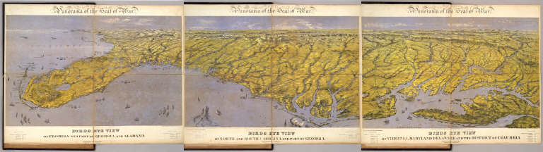
Bachmann, John
Full Title
Panorama of the Seat of War. Birds Eye View Of Florida And Part Of Georgia And Alabama. John Bachmann, Publisher, 115 & 117 Nassau St., New York. Entered ... 1861 by John Bachmann ... New York. Drawn from Nature and Lith. by John Bachmann.
List No
2665.001
Note
Shows entire Florida Peninsula. See Stephenson page 15 for a general discussion of Bachmann's civil war views. In addition to the six panoramas of the seat of war, Bachmann did a view of Richmond (Stephenson 621, illustrated p271), and of the junction of the Ohio and Mississippi Rivers (Stephenson 1.5) - which may be similar to the Kentucky - Tennessee Seat of War view, at least in terms of vantage point. Full color. Bound in black leather covers 38x30 with "Florida & Part Of Georgia & Alabama. G.G.W." stamped in gold.
Author
Carey, Mathew
Full Title
(Title Page to) Carey's American Atlas: Containing Twenty Maps And One Chart ... Philadelphia: Engraved For, And Published By, Mathew Carey, No. 118, Market Street. M.DCC.XCV. [Price, Plain, Five Dollars-Coloured, Six Dollars.]
List No
2542B
Note
First atlas of America printed in America. First edition. These maps were also published in Carey's American edition of Guthrie's Geography (1795) and most of the maps say "engraved for Carey's American edition of Guthrie's improved." The maps were again used for the 1796 edition of Carey's General Atlas, unchanged except for the Tennessee map, which is titled "Tennassee State" instead of "Tennassee Government" which is the title in both the American Atlas and the Guthrie Atlas - see Wheat and Brun, and has several counties delineated in the eastern part of the state which do not show in the 1795 edition of the map. NMM 480 (American Atlas) has "Tennassee State" indicating that Carey was not consistent. This atlas was the model for John Reid's American Atlas of 1796. This copy's maps have very strong impressions. Rebound quarter leather, marbled paper covered boards.
Author
Carey, Mathew
Full Title
A Chart of the West Indies, From the latest Marine Journals and Surveys. W. Barker sculp. Philada. Engraved for Carey's American Edition of Guthrie's Geography improved.
List No
2542.021
Note
Uncolored.
Author
Mitchell, Samuel Augustus
Full Title
Map Of Florida according to the Latest Authorities. Published by S. Augustus Mitchell Philadelphia. 1831. (inset below map) Comparative Elevation of the Principal Mountains Cities &c. in North & South America.
List No
3884.013
Note
Full color by county.
Author
[Reid, John, Winterbotham, W.]
Full Title
(Title Page to) The American Atlas; Containing The Following Maps ... New-York: Published By John Reid, Bookseller And Stationer, No. 106, Water-Street. 1796.
List No
0845B
Author
[Reid, John, Winterbotham, W.]
Full Title
An Accurate Map of the West Indies with the Adjacent Coast of America. 1796. D. Martin Sculpt. Publish'd by J. Reid New York.
List No
0845.020
Note
Uncolored.
Author
Bachmann, John
Full Title
(Composite of) Panorama of the Seat of War. Birds eye view of Florida and part of Georgia and Alabama .. North and South Carolina and part of Georgia .. Virginia, Maryland, Delaware and the District of Columbia. John Bachmann, Publisher, 115 & 117 Nassau St., New York. Entered ... 1861 by John Bachmann ... New York. Drawn from Nature and Lith. by John Bachmann.
List No
5491.000
Note
Composite map image from three separate issues.
Author
Mitchell, John
Full Title
A Map of the British and French Dominions in North America with the Roads, Distances, Limits and Extent of the Settlements.
List No
2842.000
Note
This is the second edition of this important map, dated 1755 but published in 1757, according to the British Museum. The only change from the first issue is the addition of several panels of interesting text in ocean. The original eight printed sheets of the map are here assembled in two large panels (each with four sheets) each dissected into 36 sections and mounted on linen. Uncolored, as issued. In the sixth line of the first column of the text this issue is referred to as the Second Edition One of the most important maps in American history, it went through five editions (see Stevens). We believe this second edition is scarcer than the other editions as it appears less often on the market. Compare to the first French edition of 1856 (our copy) regarding the conflicting claims of the British and French to American territory.
Author
Melish, John
Full Title
Map of the United States with the contiguous British & Spanish Possessions Compiled from the latest & best Authorities By John Melish. Engraved by J. Vallance & H.S. Tanner. Entered ... 6th day of June 1816. Published by John Melish Philadelphia. (inset) West Indies.
List No
5168.001
Note
With insets of the West Indies and a Statistical Table. This map has the distinction of being the first large scale detailed map made in the U.S. that showed the entire country from the Atlantic to the Pacific. This copy is an early state of the first edition -this is Martin's third state of the first edition and Ristow's fourth state (Ristow discovered a town and trail added in Ohio - Adelphi - making for a sub state of Martin's third state). The first state was an incomplete proof copy, making this the second/third state of the completed copy. The differences between this and the first complete state are small: Mansfield, Wooster, and Adelphi (and a trail from Adelphi to Athens and Chillicothe) added in Ohio, and "Vevay or" added before "Swiss Vineyards" in southeastern Indiana. Martin and Ristow identify seven states of the 1816 edition. Melish published new editions in 1818 (five states), 1819 (two states), 1820 (eight states), 1822 (two states), and 1823 (one state) for a total of twenty five different issues. Notwithstanding the many issues, the map has become extremely rare. A book accompanied the map (though issued separately) titled "A Geographical Description of the United States..." (see our #2424). Outline color by state or territory. This copy is dissected into 40 sections, backed with linen, and edged in brown cloth. It folds with marbled end sheets into new blue cloth folding boards and slip case 24.5x16.5 with leather label on spine reading "Melish. Map Of The United States. 1816" in gold.
Author
[Johnston, Alexander Keith, 1804-1871, Rogers, Henry Darwin]
Full Title
(Title Page to) Atlas Of The United States Of North America, Canada, New Brunswick, Nova Scotia, Newfoundland, Mexico, Central America, Cuba, And Jamaica. On A Uniform Scale. From The Most Recent State Documents, Marine Surveys, And Unpublished Materials. With Plans Of The Principal Cities And Sea-Ports, And An Introductory Essay On The Physical Geography, Products, And Resources Of North America. By Professor Henry Darwin Rogers, Of Boston, U.S., And A. Keith Johnston, F.R.S.E., F.R.G.S., F.G.S., Geographer To The Queen. London: Edward Stanford, 6, Charing Cross, S.W. [The Authors Reserve The Right Of Translation.] (on verso) Entered at Stationers' Hall, London ... 1857 by H.D. Rogers ... Massachusetts.
List No
3825B
Author
[Johnston, Alexander Keith, 1804-1871, Rogers, Henry Darwin]
Full Title
States Of South Carolina, Georgia, Alabama, And Florida. By Prof. H.D. Rogers & A. Keith Johnston, F.R.S.E. Entered in Sta. Hall. London ... & according to an act of Congress ... 1857, by H.D. Rogers ... Massachusetts. London, John Murray, Albemarle Street, Edinburgh, W. & A.K. Johnston. Engraved by W. & A.K. Johnston, Edinburgh.
List No
3825.016
Note
States and counties shown in outline printed color. Bahamas shown off the Florida coast.
Author
Andrews, A.H. & Co.
Full Title
Andrews Eight Inch Terrestrial Globe with the latest discoveries and Oceanic currents. A.H. Andrews & Co. Chicago, Ill.
List No
5517.000
Note
This eight inch globe is shown in full color with the continental United States shown separately and Alaska named as such. With a three -footed base and a horizon ring that includes the Zodiac signs and a calendar. Total height of base and globe is 15 inches. Date is estimated from Warner.
Author
Finley, Anthony
Full Title
Florida. 1831. Published by A. Finley Philadelphia. J.H. Young Sc. (inset) Plan Of Tallahassee. (inset) Plan Of Pensacola.
List No
0285.031
Note
Full color by county.
Author
Tanner, Henry S.
Full Title
Florida. (with) three inset maps: Pensacola, Tallahassee, Harbour of St. Augustine. Entered ... 1833 by H.S. Tanner ... Pennsylvania. Published by H.S. Tanner Philadelphia. (above neat line) Tanner's Universal Atlas.
List No
0977.018
Note
In full color by county or area with water route distances charted.
Author
[Mitchell, John, Raynal, G.T., Zatta, Antonio]
Full Title
(Title Page to) Storia Dell' America Settentrionale Del Signor Abate Raynal Continuata fino al present, con Carte Geografiche rappresentanti il Teatro della Guerra Civile tra la Gran Bretagna, e le Colonie Unite. A SS. EE. Li Signori Rifoormatori Dello Studio Di Padova. In Venezia, Dalle Stampe Di Antonio Zatta Con Licenza De Superiori, E Privilegio. M. DCC. LXXVIII.
List No
5007A
Note
In addition to a two volume Italian translation of Raynal's History of North America, this book contains the first edition of Zatta's twelve sheet version of Mitchell's Map of North America, plus three other maps: Il Canada, Le Isole di Terra Nuova e Capo Breton, and La Baja D' Hudson. All of these maps appeared also in Zatta's Atlante Novissimo published from 1779-1785. A second edition of the Zatta/Mitchell maps was published in 1791 (see P651). Zatta's version of Mitchell is not an exact or complete copy: the Zatta maps do not cover the far western portions of Mitchell's map, many geographical changes are introduced, and Bermuda is depicted as well as Jamaica., neither of which are shown by Mitchell. A separate map covers Newfoundland and Cape Breton, on the same scale. Maps are hand painted with outline color. Covers are quarter leather light brown marbled paper covered boards with "Raynal. Storia Dell' America Settentrionale. 1778" stamped in gilt on the new leather spine.
Author
[Mitchell, John, Raynal, G.T., Zatta, Antonio]
Full Title
Le Isole Bermude. (title cartouche) Le Colonie Unite dell' America Settentrle. di Nuova Projezione Ass. Ee. Li Signori Riformatori dello Studio di Padova. Venezia 1778, Presso Antonio Zatta, con Privilegio dell' Eccellentissimo Senato.
List No
5007.001
Note
In full color. Map appears on an unfurled scroll laid atop a drawing of the local flora and fauna. Large elaborate drawing surrounds the title cartouche for 12 map sheets when viewed as a composite.
Author
[Mitchell, John, Raynal, G.T., Zatta, Antonio]
Full Title
(Composite Map of) Le Colonie Unite dell' America Settentrle. di Nuova Projezione Ass. Ee. Li Signori Riformatori dello Studio di Padova. Venezia 1778, Presso Antonio Zatta, con Privilegio dell' Eccellentissimo Senato. (Fogl. I-XI and title page.)
List No
5007.016
Note
Composite of maps Fogl. I-XI and the title page which includes the map of Bermuda.
Author
[Carey, H. C., Lea, I.]
Full Title
Geographical, Historical, And Statistical Map Of Florida. Florida. No. 37. Drawn by F. Lucas Jr. Engraved by Young & Delleker.
List No
0122.032
Note
In full color by region surrounded by text.
Author
Melish, John
Full Title
(Title Page to) A Military and Topographical Atlas of the United States; Including The British Possessions & Florida ... By John Melish. Philadelphia, Published By John Melish. G. Palmer Printer 1815. (on verso) District of Pennsylvania ... fourteenth day of March ... 1815 ... John Melish ... hath deposited ... a book.
List No
2788B
Note
2nd edition. 9 large folding maps, 3 small maps. Melish adds four large maps, two of the St. Lawrence river area, one of the Creek Indian Territory, and one of New Orleans. Catalogue of Melish's works in front. Maps in outline color bound in half leather with fabric ties. "Military Atlas" imprinted on the spine.
Author
Melish, John
Full Title
Southern Section of the United States including Florida &c. by John Melish. 1816. Entered ... by John Melish ... 1 March 1813. Improved nth. June 1816.
List No
2788.005
Note
Large fold-out map in outline color. A small inset map of the Bermudas Isles is included. A statistical chart is included showing population and state area.
Author
Popple, Henry
Full Title
America Septentrionalis. A Map of the British Empire in America with the French and Spanish Settlements adjacent thereto. by Henry Popple. To the Queen's Most Excellent Majesty This Map is most humbly Inscribed by Your Majesty's most Dutiful, most Obedient, and most Humble Servant Henry Popple. W.H. Toms Sculp.
List No
2874.001
Note
Index map in full color with numeric notations indicating location of the accompanying maps. With eighteen inset maps and four views (Fall of Niagara, Mexico [City], Quebec and New York). Note by Edmund Halley at the bottom verifies the accuracy of the map.
Author
Popple, Henry
Full Title
(Composite Map of) A Map of the British Empire in America with the French and Spanish Settlements adjacent thereto. by Henry Popple. C. Lempriere inv. & del. B Baron Sculp. To the Queen's Most Excellent Majesty This Map is most humbly Inscribed by Your Majesty's most Dutiful, most Obedient, and most Humble Servant Henry Popple. London Engrav'd by Willm. Henry Toms & R.W. Seale, 1733.
List No
2874.002
Note
A composite of all twenty sheets of the Popple Atlas. Sheets without color.
Author
Arrowsmith, Aaron
Full Title
A Map Exhibiting all the New Discoveries in the Interior Parts of North America Inscribed by Permission To the Honorable Governor And Company Of Adventurers Of England Trading Into Hudson Bay In testimony of their liberal Communications To their most Obedient and very Humble Servant, A. Arrowsmith, Hydrographer to H.R.H. the Prince of Wales. No. 10 Soho Square, January 1st 1795. Additions to 1811. Additions to 1814. London: Published Jan. 1, 1795 by A. Arrowsmith No. 10 Soho Square. Additions to 1802 ...
List No
0032.001
Note
This issue incorporates the Lewis and Clark discoveries (and other discoveries) and remaps the entire continent west of the Mississippi. The changes between this and the last edition (1811) are monumental. This copy is from the collection of Sir Charles Broke (or Brooke, subsequently Vere). Broke was in Lower Canada with his regiment, the 5th (Northumberland) Regiment of Foot, which was at the battle of Plattsburg in 1814. Later, he was with the Army of Occupation in France, receiving the Waterloo medal despite arriving from Canada too late for the battle (from Manasek). Without color. Dissected into 40 sections and mounted on linen. Folds into a new gray cloth covered box case 29x22x7 with "North America A. Arrowsmith 1814" stamped on the spine in gold.
Author
Morse, Jedidiah
Full Title
(Title Page to) The American Geography; or, A View of the Present Situation of the United States of America ... Illustrated with two Sheet Maps-One of the Southern, the other of the Northern States, neatly and elegantly engraved, and more correct than any that have hitherto been published ... By Jedidiah Morse. Elizabeth Town: Printed by Shepard Kollock, for the Author. M,DCC,LXXXIX.
List No
2894A
Note
The first American Geography. Revised from the school text "Geography Made Easy", published in 1784. Governor William Livingston of New Jersey contributed to the text, and Morse in return dedicated the book to him (Felcone). The two maps were engraved by Amos Doolittle who compiled the map of the northern states, while Joseph Purcell compiled the southern states map. Includes the errata leaf and the tipped in leaf of corrections at the end. Bound in full leather with "Morse's Geography" in gilt on spine.
Author
Morse, Jedidiah
Full Title
A Map of the States of Virginia, North Carolina, South Carolina and Georgia Comprehending the Spanish Provinces of East and West Florida Exhibiting the boundaries as fixed by the late Treaty of Peace between the United States and the Spanish Dominions. Compiled from late Surveys and Observations by Joseph Purcell. Engraved for Morse's Geography by Amos Doolittle at New Haven, 1788.
List No
2894.001
Note
Map shows the boundaries between each state, the United States and Spanish Dominions, and each Indian Nation. Without color.
Author
Arrowsmith, Aaron
Full Title
Chart Of The West Indies And Spanish Dominions In North America. By A. Arrowsmith, 1803. Jones Smith & Co. sc. Beaufort Buildgs. Strand. London Published June 1st 1803 by A. Arrowsmith No. 24 Rathbone Place. To Admiral John Willett Payne, A distinguished Native of the West Indies ... This Chart is respectfully Dedicated by his most obedient Servt. A. Arrowsmith.
List No
4121.000
Note
The first edition, including Mexico to the Pacific, and with the dedication to Admiral John Willett Payne. In four sheets. Countries are outlined in color. The 1810 second and later editions only extend to the east coast of Mexico, presumably because Arrowsmith published his large map of Mexico in 1810. In its coverage of Mexico and Central America, this map is the largest scale and most accurate map of those areas published to date, preceding Pike's and Humboldt's maps by several years. It seems odd that Humboldt would criticize Arrowsmith for copying his map of New Spain, when Arrowsmith produced his own map (this West Indies Map) which included substantial portions of Mexico several years before Humboldt's map was issued. There are many differences between this map's rendering of Mexico and the 1810 Map of Mexico - the later map has more and better detail, but the earlier rendition is still impressive. Stevens and Tree only list two editions, 1803 and 1810, but Phillips lists an 1811 (P-Maps) and an 1816 (atlases). There probably were others.
Author
Arrowsmith, Aaron
Full Title
A Map Exhibiting all the New Discoveries in the Interior Parts of North America, Inscribed by Permission To the Honorable Governor and Company of Adventurers of England Trading into Hudsons Bay. In testimony of their liberal Communications. To Their most Obedient and very Humble Servant, A. Arrowsmith. Hydrographer to H.R.H. the Prince of Wales. No. 10 Soho Square. January 1st, 1795. Additions to 1811. Puke Sc.
List No
4189.000
Note
This issue is the seventh (Heckrotte) and makes changes to the Canadian waterways, when compared to the 1802 editions. The American West has been largely unchanged since the first issue of 1795. In the next issue (1814) there are massive changes in the American West. Map in light outline color.
Author
Robert Sayer and John Bennett (Firm)
Full Title
(Title Page to) The American Military Pocket Atlas; Being An approved Collection of Correct Maps, Both General and Particular, of The British Colonies; Especially those which now are, or probably may be The Theatre of War: Taken principally from the actual Surveys and judicious Observations of Engineers De Brahm and Romans; Cook, Jackson, and Collet; Maj. Holland, and other Officers, Employed in His Majesty's Fleets and Armies. London. Printed for R. Sayer and J. Bennet, Map and Print-Sellers (No. 53) Fleet-street.
List No
0875B
Note
This small hand atlas has six early maps, three of which are particularly important to the mapping of the American Revolution: The Seat of War in the Northern Colonies and The seat of War in the Middle British Colonies (both derived from the Evans/Pownall maps), and the Seat of War in the Southern Colonies (by Bernard Romans). Nicknamed the "Holster Atlas" because it was made for the used of British army officers. All maps in outline color, folded and bound into book with paper covered boards and quarter leather with "American Pocket Atlas" stamped in gilt on the spine.
Author
Robert Sayer and John Bennett (Firm)
Full Title
A General Map of the Southern British Colonies, in America. containing North and South Carolina, Georgia, East and West Florida, with the Neighbouring Indian Countries. From the Modern Surveys of Engineer de Brahm, Capt. Collet, Mouzon & Others; and from the Large Hydrographical Survey of the Coasts of East and West Florida. By B. Romans, 1776. (with) Plan of Charleston and ... St. Augustine. London: Printed for R. Sayer & J. Bennett ... 15th Octr. 1776.
List No
0875.005
Note
In outline color. Above the map reads, "The Seat of War in the Southern British Colonies comprehending North and South Carolina, Georgia, East and West Florida, &ca."
Author
Lloyd, J. T.
Full Title
Lloyd's Map Of The Southern States Showing all the Railroads, their Stations & Distances, Also The Counties, Towns, Villages, Harbors, Rivers And Forts. Compiled from the latest Government and other reliable Sources. 1861. New York, J.T. Lloyd Publisher 164 Broadway. London " 156 Cheapside. Entered ... 1861, by J.T. Lloyd ... New York.
List No
3128.001
Note
Map in full color by state.
Author
Tanner, Henry S.
Full Title
(Title Page to) A New American Atlas Containing Maps Of The Several States of the North American Union, Projected and drawn on a Uniform Scale from Documents found in the public Offices of the United States and State Governments, and other Original and Authentic Information, By Henry S. Tanner ... Philadelphia: Published By H.S. Tanner. 1823. (title page only) Writing Drawn and Engraved by Joseph Perkins. Barralet del. Humphrys sc.
List No
5388C
Note
The first edition with the earliest states of all the maps. Many believe this to be the finest atlas published in the United States in the 19th century. The text essay (included here) is a wonderful compilation of information on the contemporary maps that Tanner used as sources. Tanner updated the maps frequently over the next two decades, and issued several editions or compilations of the atlas with the title pages dated 1823 or 1825, but with some of the maps dated as late as 1833. The collation of our six issues shows that no two copies are alike and that the maps were being constantly updated; however the choice of maps for each edition reveals a somewhat haphazard approach with some of the earliest states of a particular map appearing the one of the later atlas editions. A completely revised edition was issued in 1839, with the title page and most of the maps dated 1839 (see P1382). Hand painted in outline color with a full color wash. Atlas is bound in half leather marbled paper covered boards with "Tanner's American Atlas" stamped in gilt on a front leather label.
Author
Tanner, Henry S.
Full Title
Map of Florida By H.S. Tanner. (with) West Part of Florida. Published by H.S. Tanner, Philadelphia. Engraved by H.S. Tanner & Assistants. Entered ... 20th day of August 1823, by H.S. Tanner... Pennsylvania. American Atlas.
List No
5388.024
Note
In full color.
Author
Arbuckle Bros.
Full Title
Florida, Virginia, Indiana, Rhode Island. Copyright 1889 Arbuckle Bros. N.Y.
List No
0027.004
Note
Sheet with maps of four states in full color. Florida is noted for its oranges and Rhode Island (called "Little Rhody") for its sewing thread. Each card measures 7.5 x 12.5 cm.
Author
[Asher & Company, Russell, Benjamin B.]
Full Title
(Covers to) The Historical War Map. Asher & Co. Entered ... 1862, by Asher & Co. ... Indiana. E.R. Jewett & Co. Engravers, Buffalo, N.Y.
List No
3423A
Author
[Asher & Company, Russell, Benjamin B.]
Full Title
The Historical War Map. Asher & Co. Entered ... 1862, by Asher & Co. ... Indiana. E.R. Jewett & Co. Engravers, Buffalo, N.Y.
List No
3423.001
Note
Eliminates text on map, adds text titled "Rebellion Record" in 24 pages, 4 small maps. Last battle listed in text is August 9, 1862. The map is the same as the earlier Asher map, but adds battles at Vicksburg and Baton Rouge. Has statistics of the Southern States below the map. Map has printed outline color by state; folded into green card board covers 13.5x8.5 printed with "The Historical War Map. Benj. B. Russell, No. 515 Washington Street, Boston."
Author
Hood, Washington
Full Title
Map Of The Seat Of War In Florida. Compiled By Order Of The Hon. Joel R. Poinsett, Secretary Of War, under the Direction of Col J.J. Abert U.S. Topt. Engineer, from the reconnoissances of the Officers of the U.S. Army, by Wash: Hood. Bureau of U.S. Topographical Engineers Washington City 1838. W.J. Stone Sc. Washn. City.
List No
2209.000
Note
Precursor of MacKay/Blake map of 1839. A very detailed map. A comparison of this with the MacKay/Blake map does not show significant differences, except in the north. Taylor/MacKay do not mention Hood's map as a source. Map is without color.
Author
Burr, David H., 1803-1875
Full Title
Map of Florida Exhibiting the Post Offices, Post Roads, Canals, Rail Roads, &c. By David H. Burr. (Late Topographer to the Post Office.) Geographer to the House of Representatives of the U.S. John Arrowsmith. (with) inset map of Florida panhandle. Entered ... July 10th, 1839, by David H. Burr ... District of Columbia.
List No
0104.008
Note
In full color by county. Postal routes by coach, stage, sulkey, cross, rail roads and canals shown. In 8 sections mounted on linen. Label on back states "No. 8. Florida."
Author
Colton, G.W.
Full Title
Florida. (with) Plan Of The Florida Keys. Published By J.H. Colton & Co. No. 172 William St. New York. Entered ... 1855 by J.H. Colton & Co. ... New York. No. 30.
List No
0149.036
Note
In full color by county.
Author
Morse, Jedidiah
Full Title
A Map of the States of Virginia, North Carolina, South Carolina, and Georgia; Comprehending the Spanish Provinces of East and West Florida: Exhibiting the Boundaries as fixed by the late Treaty of Peace between the United States and the Spanish Dominions. Compiled from late Surveys & Observations by Joseph Purcell. W. Harrison Senr. & Junr. sc. Engraved for Morse's Geography. Publish'd by John Stockdale Jany. 25th 1792.
List No
0632.014
Note
Map shows the boundaries between the United States and the Spanish Dominions, the individual states, and the territories claimed by the Indian nations. Map without color.
Author
Drew, Columbus
Full Title
(Covers to) Drew's New Map Of The State Of Florida Showing the Progress of the U.S. Surveys, the Completed & Projected Railroads, The Different Railroad Stations And Growing Railroad Towns, The New Towns on the Rivers and interior, and the New Counties, up to the Year 1870. Published by C. Drew, Bookseller & Stationer, Jacksonville, Fla. Copy right secured according to law. Engraved & printed by Julius Bien, N.Y.
List No
5190A
Author
Drew, Columbus
Full Title
Drew's New Map Of The State Of Florida Showing the Progress of the U.S. Surveys, the Completed & Projected Railroads, The Different Railroad Stations And Growing Railroad Towns, The New Towns on the Rivers and interior, and the New Counties, up to the Year 1870. Published by C. Drew, Bookseller & Stationer, Jacksonville, Fla. Copy right secured according to law. Engraved & printed by Julius Bien, N.Y.
List No
5190.001
Note
This is the earliest issue of this map that we have seen, earlier than any listed in Phillips or Fitzgerald. Compared to our 1876 edition (see #5040) there is far less railroad development shown on the map and the railroads are not listed to the right of the Florida Peninsula, as they are on the 1876 issue. Julius Bien is credited as engraver and printer, which is removed on the 1876 edition. There is no copyright notice. Drew's map is probably the only pocket map of Florida published in Florida in the 19th century. Not much is known about Drew - he is listed on the map as "Bookseller & Stationer" in Jacksonville. Full color by county. Map is folded into stamped dark brown cloth covers 15x9.5 with "Drew's New Map Of Florida" in gilt.
Author
Humboldt, Alexander von, 1769-1859
Full Title
(Title Page to) Atlas Geographique Et Physique Du Royaume De La Nouvelle-Espagne, Fonde Sur Des Observations Astronomiques, Des Mesures Trigonometriques Et Des Nivellemens Barometriques. Par Al. De Humboldt. Paris, Chez F. Schoell, Rue Des Fosses-Saint-Germain-L'Auxerrois, No. 29. 1811. De L'Imprimerie De J.H. Stone.
List No
0328C
Note
First French edition (although some copies have 1808 on the title page). Stamp of Russian Imperial Library at Tsarkoe Selo. This atlas has the important "Carte Generale du Royaume de la Nouvelle Espagne" on two large folio sheets, originally drawn by Humboldt in 1803-4. Arrowsmith and Pike used this map as a base for their maps of Mexico and the southwest. Maps are without color and bound in full brown leather covered boards with "Voyage De Humboldt Et Bonplan. Atlas Geographique Et Physique Du Royaume De La Nouvelle-Espagne." stamped on the spine in black ink.
Author
Humboldt, Alexander von, 1769-1859
Full Title
Carte Du Mexique et des Pays Limitrophes Situes Au Nord et a l'est Dressee d'apres la Grande Carte de la Nouvelle Espagne De Mr. A. De Humboldt et d'autres Materiaux par J.B. Poirson. 1811. 2. Grave par Barriere. et l'ecriture par L. Aubert. Se trouve a Paris chez F. Schoell, Libraire.
List No
0328.004
Note
An uncolored map of Mexico, the United States and the West Indies.
Author
Jefferys, Thomas
Full Title
(Title Page to) The American Atlas: Or, A Geographical Description Of The Whole Continent Of America ... Engraved On Forty-Eight Copper Plates, By The Late Mr. Thomas Jefferys, Geographer to the King, and Others. London, Printed and Sold by R. Sayer and J. Bennett, Map and Print Sellers, No. 53, Fleet-Street. MDCCLXXVI.
List No
0346B
Note
One of the most important atlases of the American Revolutionary War period. There are 22 maps on 29 sheets. The majority of the important large scale maps of the colonies are here, appearing together for the first time after having been issued as separates by Jefferys in the 1750's and 60's. This copy is the 1st 1776 edition, with the Quebec map, without the Lake Champlain map, as issued. This copy is the same as NMM 361, except the title page says 48 copper plates rather then the 49 on NMM 361, and on the NY/NJ map it is Major Holland rather than Capt. Holland (our NY/NJ map says Major-the 1775 says Capt-our index omits Holland-the reproduction atlas map copy says Major, and Carver is eliminated (why?); probably indicates that this was slightly before the NMM 361, as the 1775 title page is identical to this one (although we have not seen it yet-relying on P1165), except for the date. Summary of editions: 1775 (actually issued in 1776, has Evans Middle Colonies map, P1165); 1776 1st issue (our copy with 48 on TP, Quebec replaces Evans, N.Y- & N.J. is dated 1776, rather than 1775 and adds Pownall corrections and improvements); 1776 2nd issue (NMM 361, 49 on TP); 1777 (1776 on TP, N. Amer changes from Bowen/Gibson to Pownall version with 1777 on map, adds L. Champlain, P1166 -our reproduction copy); 1778 (P3659a, NMM 362, no changes from 1777); 1782 (P1169, no changes except Phillips says this copy has 1783 ed of N. Amer., inserted-later?) Our TP is a transition from 1775 to NMM361; NMM361 anticipates the Lake Champlain map in saying 49 plates. Covers are half leather brown cloth covered boards with "Jeffery's American Atlas. London MDCCLXXVI" stamped in gilt on the spine.
Author
Jefferys, Thomas
Full Title
(Composite of) An Accurate Map Of North America. Describing and distinguishing the British and Spanish Dominions on the great Continent; According to the Definitive Treaty Concluded at Paris 10th Feby. 1763. Also all the West India Islands Belonging to, and possessed by the Several European Princes and States. The whole laid down according to the latest and Most authentick Improvements, By Eman Bowen Gegr: to His Majesty and John Gibson Engraver. London. Printed for Robert Sayer No. 53 Fleet Street as the Act Directs 2d. July 1775.
List No
0346.008
Note
In outline color with elaborate cartouche giving seven different scales and an explanation of the symbols used. Treaty reproduced along the right side of the large outline color map.
Author
Mitchell, Samuel Augustus
Full Title
Florida. (with) three inset maps: Pensacola, Tallahassee, Harbour of St. Augustine. Published By S. Augustus Mitchell, N.E. corner of Market & 7th Street Philada., 1846. Entered ... 1846 by H.N. Burroughs ... Pennsylvania.
List No
0537.022
Note
In full color by county or region. Water route distances charted.
Author
Mitchell, Samuel Augustus
Full Title
County Map Of Florida. 25. (with) County Map of South Carolina. 26. (with) Inset Map Of Charleston Harbor. 27. Entered ... 1860, by S. Augustus Mitchell, Jr. ... Pennsylvania.
List No
0565.018
Note
States in full color by county.
Author
Morse, Jedidiah
Full Title
(Title Page to) The American Geography; Or, A View of the Present Situation of the United States of America ... By Jedidiah Morse, A.M. A New Edition, Revised, Corrected, and Greatly Enlarged, by the Author, and Illustrated with Twenty-Five Maps. London: Printed for John Stockdale, Piccadilly. 1794.
List No
0632A
Note
25 maps, including the Filson Map of Kentucky. Adds a short section on Europe, Asia and Africa that is not in the U.S. edition of vol 1 (rather it is in vol 2). All maps uncolored. Rebound in half leather with title on the spine.
Author
Morse, Jedidiah
Full Title
A Map of East and West Florida. Published Octr. 18, 1794, by I. Stockdale, Piccadilly.
List No
0632.022
Author
Perrine, Charles O.
Full Title
(Covers to) Perrine's New Topographical War Map Of The Southern States. Taken from the latest Government Surveys and Official Reports. E.R. Jewett & Co., Engravers, Buffalo, N.Y. Entered ... 1863, by C.O. Perrine ... Indiana. (inset) Southern Part Of Florida.
List No
5412A
Author
Perrine, Charles O.
Full Title
Perrine's New Topographical War Map Of The Southern States. Taken from the latest Government Surveys and Official Reports. E.R. Jewett & Co., Engravers, Buffalo, N.Y. Entered ... 1863, by C.O. Perrine ... Indiana. (inset) Southern Part Of Florida.
List No
5412.001
Note
Accompanies "A Concise History of the War" by Capt. John S. Bishop. Battles in the text are dated from January, 1861, to November, 1863. Text is stereotyped by the Franklin Type Foundry, Cincinnati. Map has printed outline color by state. Covers are orange card board 15x10 with "Perrine's New Topographical War Map Of The Southern States With A Chronology Of The Great Rebellion ... R.R. Landon, Agt., Chicago, Ill. E.R. Jewett & Co. Eng. Buffalo, N.Y. Price, 50 cts. Sent, Post-Paid." printed in black.
Author
Phelps & Watson
Full Title
(Covers to) Phelps & Watson's Historical And Military Map Of The Border & Southern States. Published By Phelps & Watson, 18 Beekman St. New York, 1863 ... Entered ... 1862 by Phelps & Watson ... New York.
List No
3147A
Author
Phelps & Watson
Full Title
Phelps & Watson's Historical And Military Map Of The Border & Southern States. Published By Phelps & Watson, 18 Beekman St. New York, 1863 ... Entered ... 1862 by Phelps & Watson ... New York.
List No
3147.001
Note
1st edition, copyright 1862. Later editions in 1864, 65, and 67. The map is the same as the 1864 edition, except that the list of Battles is for 1862 and 1863 only and the publisher's address is 18 instead of 16 Beekman Street. There are also blue dots on this edition only for the population statistics in each state. Full color by state. Map is folded into orange card board covers 17x11 with "New Historical War Map" printed in black.
Author
Tanner, Henry S.
Full Title
United States of America: by H.S. Tanner, 1829. Entered ... the 10th day of June, 1829, by H.S. Tanner ... Pennsylvania. Engraved by H.S. Tanner, assisted by E.B. Dawson, W. Allen & J. Knight.
List No
0975.001
Note
The first edition. With inset maps of fourteen cities, South Florida, Oregon and the Mandan Districts (with a chart of the Outlet of Oregon River), two Statistical tables, and fourteen profiles of portages, canals and railroads. With Tanner's "Memoir...Intended to Accompany His New Map of the United States." This was one of the most popular general maps of the eastern United States and went through several editions (Phillips, Karrow, Yale, and Howes show editions of 1829, 1830, 1832, 1834, 1836, 1838, 1839, 1841, 1843, and 1850). Distances on all major roads are shown between towns, an effort that Tanner states in the Memoir caused the map to take twice as long to produce. Latitude is measured from Washington, D.C., making this a truly "American" map. Although Tanner states that "The new map of the United States is founded on, and embraces generally, the valuable and original information, contained in our American Atlas," the general form of the map bears a striking resemblance to J.&A. Walker's Map of the United States published in London in 1827, a fact that Tanner does not mention. Howes (T23) shows "An Alphabetical Index to the four sheet map of the United States," also to accompany editions of the map. This is one of best early large maps of the United States and the premier map for its period, without equal until Mitchell produced the first edition of his Reference and Distance Map of the United States in 1834. Kept in a half leather case with ties to keep it closed. Measuring 23x18, it has "Tanner's United States" embossed on the red leather spine.
Author
[Finley, Anthony, Vance, David H.]
Full Title
Map Of The United States Of North America. Compiled from the Latest And Most Authentic Information By David H. Vance. Philadelphia Published by Anthony Finley. Entered ... July 12th, 1825. Engraved by J.H. Young. (inset) Map Of North America Including All The Recent Geographical Discoveries 1825. (inset profile) Comparative Elevation of the Principal Mountains and Hills in the United States.
List No
3961.001
Note
Full color by county.
Author
Bradford, Thomas G.
Full Title
Florida. Entered ... 1838, by T.G. Bradford ... Massachusetts. Engraved by G.W. Boynton.
List No
0089.031
Note
In full color.
Author
Finley, Anthony
Full Title
Map of Florida according to the Latest Authorities. (with) Comparative Elevation of the Principal Mountains Cities &c. in North & South America. J.H. Young Sc. Philadelphia Published by A. Finley 1826.
List No
0278.013
Note
In full color by county. Elevation map includes list of mountain and city heights in feet.
Author
Finley, Anthony
Full Title
(Title Page to) A New American Atlas, Designed Principally To Illustrate The Geography Of The United States Of North America; In Which Every Country In Each State And Territory Of The Union Is Accurately Delineated, As Far As At Present Known: The Whole Compiled From The Latest And Most Authentic Information. Philadelphia: Published By Anthony Finley, At The North-East Corner Of Chestnut And Fourth Streets. 1826.
List No
0278B
Note
This atlas was Finley's attempt to compete with Henry Tanner's American Atlas - the maps are grouped in much the same arrangement as Tanner used and the cartography and engraving are equal to Tanner, although the scale and map size are smaller. There are only two issues that we have seen, both dated 1826 on the title page, but with different dates on the maps. In the first issue, the maps are dated 1824-26; in the second issue (this copy) the maps are dated 1826-27. Finley continued to publish the maps as pocket maps until 1831 when he sold his map and atlas copyrights to Mitchell, who reissued this American Atlas only once, in 1831 (see our #3884) but continued to issue the pocket maps, with updates, until about 1850. Bound in half leather marbled paper covered boards with red leather label stamped with "Finley's American Atlas" in gilt. Full color.
Author
Johnson, A.J.
Full Title
Johnson's Florida By Johnson & Browning. (with) Plan Of The Florida Keys. No. 30.
List No
2905.019
Note
In full color by county.
Author
Bowen, Emanuel
Full Title
A new & accurate map of Louisiana, with part of Florida and Canada, and the adjacent countries. Drawn from surveys, assisted by the most approved English & French maps & charts. The whole being regulated by astronomical observations. By Eman. Bowen. (London: Printed for William Innys, Richard Ware, Aaron Ward, J. and P. Knapton, John Clarke, T. Longman and T. Shewell, Thomas Osborne, Henry Whitridge ... M.DCC.XLVII)
List No
3733.058
Note
Engraved map. Includes geographical note and ornamental cartouche. Relief shown pictorially.
Author
Bowen, Emanuel
Full Title
A new & accurate map of the provinces of North & South Carolina, Georgia &c. Drawn from the late surveys and regulated by astronl. observatns. By Eman. Bowen. (London: Printed for William Innys, Richard Ware, Aaron Ward, J. and P. Knapton, John Clarke, T. Longman and T. Shewell, Thomas Osborne, Henry Whitridge ... M.DCC.XLVII)
List No
3733.059
Note
Engraved map. Includes note on the Cherokees and ornamental cartouche. Relief shown pictorially.
Author
Bowen, Emanuel
Full Title
Particular draughts and plans of some of the principal towns and harbours belonging to the English, French, and Spaniards, in America and West Indies. Collected from the best authorities, by Eman. Bowen. (London: Printed for William Innys, Richard Ware, Aaron Ward, J. and P. Knapton, John Clarke, T. Longman and T. Shewell, Thomas Osborne, Henry Whitridge ... M.DCC.XLVII)
List No
3733.067
Note
Thirteen maps on 1 sheet. Engraved. Relief shown pictorially; depths by soundings. Contents: A draught of Boston Harbour -- A draught of New York and Perthamboy Harbour -- Fort Royal in Martinico -- The Harbour of Placentia -- The Harbour of Anapolis Royal -- Harbour of St. Augustine -- The Harbour of Providence -- The Havana -- Bay of St. Iago in Cuba -- A plan of the Town and Harbour of Cartagena -- A plan of the town and harbour of Louisbourg in the island of Cape Breton ... -- The town and harbour of Charles Town in South Carolina. Scale (ca. 1:12,000) -- A Plan of the Harbour Town and forts of Porto Bello, when taken by Admiral Vernon on Novr. 22d. 1739 with 6 ships only.
Author
Bowen, Emanuel
Full Title
(Title Page to) A complete system of geography. Being a description of all the countries, islands, cities, chief towns, harbours, lakes, and rivers, mountains, mines, &c. of the known world ... In two volumes. The whole illustrated with seventy maps, by Emanuel Bowen, Geographer to His Majesty, being all new-drawn and ingraved according to the latest discoveries and surveys; making, of themselves, a complete atlas, for the sse of gentlemen, merchants, mariners, and others, who delight in history and geography ...Vol. 2. London: Printed for William Innys, Richard Ware, Aaron Ward, J. and P. Knapton, John Clarke, T. Longman and T. Shewell, Thomas Osborne, Henry Whitridge ... M.DCC.XLVII.
List No
3733C
Note
In the title Bowen states that he is "Preserving all that is useful in the Fourth and Last edition of the Complete Geographer, publish'd under the name of Herman Moll, &c." The 70 maps were also published in two other forms: in "A Complete Atlas" of 1752, and as the Maps for the "Complete Collection of Voyages" by John Harris, in 1744-48 (M&B). The text is massive and interesting, and there are several important maps of America: America, West Indies, Mexico, Louisiana, Carolina, Virginia, Pennsylvania et al, and Newfoundland et al. The map of the World in Hemispheres is lacking in this copy. Both volumes are newly bound in full brown leather covered boards with "Geography. Vol. 1" and -Geography. Vol. 2" embossed on the spine in gilt.
Author
Jefferys, Thomas
Full Title
An index map to the following sixteen sheets, being a compleat chart of the West Indies, with letters in the margin to direct the placing the different sheets in their proper places. London, printed for Robt. Sayer, Map & Printseller, no. 53 in Fleet Street, as the Act directs 20th. Feby. 1775.
List No
4723.007
Note
Engraved map. Relief shown pictorially.
Author
Jefferys, Thomas
Full Title
The Coast of West Florida and Louisiana. By Thos. Jefferys, Geographer to His Majesty. (London, printed for Robt. Sayer, Map & Printseller, no. 53 Fleet Street, as the Act directs 20th Feby. 1775)
List No
4723.009
Note
Engraved nautical chart showing rhumb lines, the Flota's track from Vera Cruz to Havana to avoid the trade winds, currents, etc. Depths shown by soundings and one isoline. Includes notes. Sheet DF.3 of "... a complete chart of the West Indies ..."
Author
Jefferys, Thomas
Full Title
The Peninsula and Gulf of Florida or Channel of Bahama with the Bahama Islands. By Thos. Jefferys, Geographer to His Majesty. London, printed for Robt. Sayer, Map & Printseller, no. 53 in Fleet Street, as the Act directs 20 Feby. 1775.
List No
4723.010
Note
Engraved nautical chart, showing swamps, rhumb lines, sailing course, etc. Relief shown pictorially; depths by soundings. Sheet DG.4 of "... a complete chart of the West Indies ..."
Author
Jefferys, Thomas
Full Title
The coast of Yucatan from Campeche to Bahia del Ascension; with the west end of Cuba. By Thos. Jefferys, Geographer to His Majesty. London, printed for Robt. Sayer, Map & Printseller, no. 53 Fleet Street, as the Act directs 20th. Feby. 1775.
List No
4723.012
Note
Engraved nautical chart showing tracks, rhumb lines, currents, etc. Relief shown pictorially; depths by soundings and isoline. Sheet CF.6 of "... a complete chart of the West Indies ..."
Author
Jefferys, Thomas
Full Title
The Island of Cuba with part of the Bahama Banks & the Martyrs. By Thos. Jefferys, Geographer to his Majesty. London, printed for Robt. Sayer, Map & Printseller, no. 53 in Fleet Street, as the Act directs 20 Feby. 1775.
List No
4723.013
Note
Engraved nautical chart showing tracks, rhumb lines, currents, etc. Relief shown pictorially; depths by soundings. Covers also the southern Florida Keys and Dry Tortugas. Sheet CG.7 of "... a complete chart of the West Indies ..."
Author
Jefferys, Thomas
Full Title
(Composite of) Compleat chart of the West Indies ... London, printed for Robt. Sayer, Map & Printseller, no. 53 in Fleet Street, as the Act directs 20th. Feby. 1775.
List No
4723.024
Note
Sixteen engraved nautical charts with index sheet. Show rhumb lines, currents, tracks, anchorages, etc. Relief shown pictorially; depths by soundings. Sheets numbered 1 (index map), DE.2-AI.17.
Author
Jefferys, Thomas
Full Title
(Engraved title page to) The West-India atlas: or, a compendious description of the West-Indies: illustrated with forty one correct charts and maps, taken From actual surveys. Together with an historical account of the several countries and islands which compose that part of the world. By the late Thomas Jefferys, Geographer to the King. London: Printed for Robert Sayer and John Bennett, Map, Chart, Print-Sellers, and Globe Makers, Fleet-Street, M,DCC,LXXXIII.
List No
4723B
Note
This is a superb atlas of the West Indies and a companion atlas to Jeffery's American Atlas also first issued in 1775. The latest date on the charts in this copy is 1788 (The Cape Verd Islands). There is a beautifully illustrated title page that precedes the main title page, which reads "The West Indian Atlas..." Jefferys died in 1771; Sayer and Bennet acquired his materials in preparation for this atlas, and published the atlas posthumously under his name (as they did with the American Atlas) in 1775. The heart of this atlas and the most detailed part is the sixteen sheet large chart and index sheet of the whole of the West Indies. The rest of the atlas consists of charts of the Atlantic Islands and the British Channel, as well as individual maps and charts of seventeen islands in the West Indies. Twenty seven pages of text gives the sources for the maps and charts, and a historical account of the West Indies. Three of the large chart maps also appeared in the American Atlas. Comparing the two Florida sheets in this atlas to the same sheets in the 1775 American Atlas, numerous changes to the coast lines and other features appear. That would indicate that Sayer updated the charts as the atlas was reissued - Phillips shows issues of 1775, 1781, 1787, 1794, 1796, 1807, and 1818. With the 1794 and later editions, 20 maps are added of various additional islands. Sayer and Bennet also published in 1775 a smaller version of this atlas called "The West India Islands: From Actual Survey and Observations..." that consisted of the same text, a general chart of the Islands, and the same sixteen or seventeen (depending on the edition) charts of the islands that appear in the larger version (P3942). Finally, Jefferys himself published in 1762 "A Description of the Spanish Islands and Settlements on the Coast of the West Indies" which was issued in quarto, with a general chart and 32 maps and plans of harbors and towns (P3941).
Author
Jefferys, Thomas
Full Title
(Title page to) The West-India atlas: or, a compendious description of the West-Indies: illustrated with forty one correct charts and maps, taken From actual surveys. Together with an historical account of the several countries and islands which compose that part of the world. By the late Thomas Jefferys, Geographer to the King. London: Printed for Robert Sayer and John Bennett, Map, Chart, Print-Sellers, and Globe Makers, Fleet-Street, M,DCC,LXXXIII.
List No
4723C
Note
This is a superb atlas of the West Indies and a companion atlas to Jeffery's American Atlas also first issued in 1775. The latest date on the charts in this copy is 1788 (The Cape Verd Islands). There is a beautifully illustrated title page that precedes the main title page, which reads "The West Indian Atlas..." Jefferys died in 1771; Sayer and Bennet acquired his materials in preparation for this atlas, and published the atlas posthumously under his name (as they did with the American Atlas) in 1775. The heart of this atlas and the most detailed part is the sixteen sheet large chart and index sheet of the whole of the West Indies. The rest of the atlas consists of charts of the Atlantic Islands and the British Channel, as well as individual maps and charts of seventeen islands in the West Indies. Twenty seven pages of text gives the sources for the maps and charts, and a historical account of the West Indies. Three of the large chart maps also appeared in the American Atlas. Comparing the two Florida sheets in this atlas to the same sheets in the 1775 American Atlas, numerous changes to the coast lines and other features appear. That would indicate that Sayer updated the charts as the atlas was reissued - Phillips shows issues of 1775, 1781, 1787, 1794, 1796, 1807, and 1818. With the 1794 and later editions, 20 maps are added of various additional islands. Sayer and Bennet also published in 1775 a smaller version of this atlas called "The West India Islands: From Actual Survey and Observations..." that consisted of the same text, a general chart of the Islands, and the same sixteen or seventeen (depending on the edition) charts of the islands that appear in the larger version (P3942). Finally, Jefferys himself published in 1762 "A Description of the Spanish Islands and Settlements on the Coast of the West Indies" which was issued in quarto, with a general chart and 32 maps and plans of harbors and towns (P3941).
Author
L'Isle, Guillaume de, 1675-1726
Full Title
L'Amerique Septentrionale. Dressee sur les observations de Mrs. de l'Academie Royale des Sciences, & quelques autres, & sur les Memoires les plus recens. Par G. de l'Isle, Geographe. A Paris, chez l'Auteur sur le Quai de l'Horloge, avec Privilege du Roy pour 20. ans, 1700.
List No
4764.095
Note
Engraved map in outline color. Relief shown pictorially. Shows routes of Cortez, Gaetan, Drake, Medana and Olivier in the Pacific. Extends east to the Azores. Below title cartouche, the imprint of L. Renard Libraire, Amsterdam has been erased from the engraving plate. Title cartouche is by "N. Guerard, inv. et fec." "Avertissement" is in a cartouche below bar scales.
Author
L'Isle, Guillaume de, 1675-1726
Full Title
Carte de la Louisiane et du Cours du Mississipi. Dressee sur un grand nombre de Memoires en trautres sur ceux de Mr. le Maire. Par Guillaume Delisle de l'Academie Rle. des Sciences. A Paris, chez l'Auteur le Sr. Delisle sur le Quay de l'Horloge, avec Privilege du Roy Juin 1718.
List No
4764.098
Note
Engraved map in outline color. Shows Indian villages, "nations derangees, nations detruites," the route of de Soto, Moscoso, Cavelier, Tonty and Denis, etc. Relief shown pictorially. Covers area from Lake Champlain to New Mexico and south to Florida and Texas. Inset map: Carte particuliere des embouchures de la Rivie. S. Louis et de la Mobile, i.e., Mississippi Delta area and Mobile Bay. Kohl states this is the mother and main source of all later maps of the Mississippi.
Author
L'Isle, Guillaume de, 1675-1726
Full Title
Carte du Mexique et de la Floride, des Terres Angloises et des Isles Antilles, du cours et des environs de la Riviere de Mississipi. Dressee sur un grand nombre de memoires principalemt. sur ceux de Mrs. d'Iberville et le Sueur. Par Guillaume Del'Isle, Geographe de l'Academie Royale des Sciences. A Paris, chez l'Auteur sur le Quai de l'Horloge, (avec) Privilege du Roy po. 20. ans, 1703 (1708 or later)
List No
4764.099
Note
Engraved map in outline color. Shows Indian villages, etc. Relief shown pictorially. Covers area from the Great Lakes to Colombia and from the Gulf of California to Trinidad. "It was the first printed map to portray accurately the course and mouth of the Mississippi River," Martin. Title cartouche by "C. Simonneau, fecit." Imprint of L. Renard Libraire has been erased from engraving plate.
Author
Greenleaf, Jeremiah
Full Title
Map of the Territory of Florida.
List No
4850.056
Note
Full color by region.
Author
Pownall, Thomas
Full Title
(Composite of) A new map of North America, with the West India Islands. Divided according to the Preliminary Articles of Peace, signed at Versailles, 20. Jan. 1783, wherein are particularly distinguished the United States, and the several provices, governments &ca. which compose the British Dominions; laid down according to the latest surveys, and corrected from the original materials, of Goverr. Pownall, Membr. of Parliamt., 1783. London, printed for Robt. Sayer, Map, Chart & Printseller, no. 53, Fleet Street, as the Act directs August 15th 1786.
List No
0411.042
Note
Engraved map in outline color. Printed on 4 sheets. Shows forests, banks, forts, Native American villages, trading posts, mines, salt pits, sailing courses, etc. Relief shown pictorially. Includes 2 inset maps: A passage by land to California. Discovered by Father Eusebius Francis Kino, a Jesuit, between the years 1698 and 1701 before which and for a considerable time since California has always been described in all charts & maps as an island -- A particular map of Baffin and Hudson's Bay. and geographic notes on map. Includes geographic notes on map, and "Article III" of the Treaty. Prime meridians: Ferro and London. David Rumsey Collection copy mounted as 2 sheets. (W 116--W 45/N 55--N 5)
Author
Burr, David H., 1803-1875
Full Title
Map of the Territory of Florida. W.F.H. & J.H. Sc. Entered ... 1834 by Illman & Pilbrow ... New York.
List No
4628.056
Note
In full color by county or region.
Author
Cram, George Franklin
Full Title
Cram's Rail Road & Township Map of Florida. Published by Geo. F. Cram. Proprietor of the Western Map Depot. 66, Lake St. Chicago Ills. 1875.
List No
5370.006
Note
Map in full color by county. Inset map of southern Florida included. The railroad lines are clearly marked. (Note: The map has been rotated 90 degrees clockwise for readability.)
Author
Dessiou, J. Foss
Full Title
A General Chart of the West Indies And Gulf Of Mexico, describing The Gulf and Windward Passages, Coast Of Florida, Louisiana And Mexico, Bay of Honduras and Musquito Shore; likewise the Coast Of The Spanish Main To The Mouths Of The Orinoco. Drawn from the Surveys taken by Mr. Geo. Gauld, and others, the New Spanish Charts, &c. and adjusted from recent Observations, By J. Foss Dessiou, Master of the Royal Navy. Approved by the Chart Committee of the Admiralty. London, Published by W. Faden ... Charing Cross, June 4, 1808. Engraved by J. Tyrer, Chapel St. Pentonville. (inset) Chart Of The Virgin Islands. (inset) Chart Of The Coast Of Biruquete, Panama & Veragua, From Point Solano To Point Burica.
List No
4754.000
Note
With two inset charts. This is a highly detailed general chart of the West Indies that is similar in scope and size to Arrowsmith's chart of the same area, but Dessiou's chart gives more detail to the coast lines, harbors, water depths, currents and less detail of the inland areas. We can find no specific reference to this wonderful chart, other than Tooley's Dictionary. Dessiou is listed in the National Maritime Museum Catalog as the author of a London edition of Le Petit Neptune Francais, also published by Faden. Scarce. Map is dissected into 40 sections, and mounted and edged with linen. Outline color. The map has a paste down label on the end sheet reading "Sold by Wm. Faden, Geographer to the King, Charing Cross". Folds into a new blue cloth folding case 32.5x21 with "Chart Of The West Indies J. Foss Dessiou 1808" stamped in gilt on the spine.
Author
Fullarton, A. & Co.
Full Title
Southern Ports & Harbours in the United States. By J. Bartholomew, F.R.G.S. (with) eight maps. LXa. A. Fullarton & Co. London and Edinburgh.
List No
3007.062
Note
Maps in full color. Eight maps include: (1) Washington. (2) Beaufort Harbour. North Carolina. (3) Charleston Harbour. South Carolina. (4) Mobile Bay. (5) Pensacola Bay. Florida. (6) Key West Island. Florida. (7) Delta of the Mississippi & Environs of New Orleans. (8) Galveston Entrance. Texas.
Author
Kitchin, Thomas
Full Title
(Title Page to) A general atlas, describing the whole universe: being a complete collection of the most approved maps extant; corrected with the greatest care, and augmented from the latest discoveries. The whole being an improvement of the maps of D'Anville and Robert. Engraved in the best manner on sixty-two copper-plates, by Thomas Kitchin, Senior, and Others. London: printed For Robert Sayer, no. 53, Fleet-Street, (1790).
List No
0411B
Note
Late issue. Many of the maps are double sheet. This atlas was later expanded to become the New Universal Atlas (see David Rumsey Collection copy). Some of these maps also appeared in the American Atlas by Jefferys. There are actually 23 large maps, on 35 connected sheets, produced from 62 copper plates. Maps are hand painted with outline and full color and bound in half leather tan marbled paper covered boards with "General Atlas" stamped in gold on the spine. Inscription inside front cover in pen-and-ink: R. Sayer pub, 53 Fleet ... 8th, 1791 ...
Author
Lange, Henry, 1821-1893.
Full Title
Alabama, Georgia, Sud Carolina und Florida. H. Lange's Atlas v. Nord Amerika Blatt V. Braunschweig: Verlag v. George Westermann. Lith. Anst. von L. Kraatz in Berlin.
List No
2743.005
Note
Engraved map. Borders hand col. Shows roads, railroads, swamps, etc. Relief shown by hachures.
Author
Lewis, Samuel
Full Title
The travellers guide. A new and correct map of the United States, including great portions of Missouri Territory, Upper & Lower Canada, Nova Scotia, New Brunswick, The Floridas, Spanish Provinces &c. Collected and compiled from the most undoubted authorities by Samuel Lewis, Geographer and Draftsman, 1819. Published, printed and coloured by Henry Charles, Philada. Copy Right secured according to law.
List No
2482.000
Note
Highly detailed, goes west to 110th meridian. Streeter 3804, 3803. Probably influenced by Melish, nonetheless this is an outstanding map, with much of interest in the Missouri Territory. There is a small vignette of a "Traveler" placed over the title, indicating that this was a map to be used as a travel guide. Shows the new Alabama Territory, an interesting configuration of Illinois around Lake Michigan, and strange east west running mountain ranges leading to the Rockies. Lewis and Clark information is incorporated in the upper Missouri River area. The northern boundary with Canada is strange: it follows the 47.5 parallel and the Upper Missouri River. Outline color. Prime meridians: Greenwich and Philadelphia.
Author
Lewis, Samuel
Full Title
A Correct Map of the United States, With The West Indies, from the best Authorities by Samuel Lewis 1817. 2nd Edition. Containing the Seat of War &c. Published by T.L. Plowman, Philadelphia, 1813. Entered ... 22nd Mar.
List No
3324.001
Note
The U.S. portion of the map is identical to Maclure's 1809 base map. This map seems to have a long history. It first appears as the Maclure base in 1809 (indicating that it must have been published as a Political map at that time, but we can find no record of it), then it shows up in Amer. Phil. Soc. 563 as the same map but dated 1811, then a second copy in the same holding dated 1813 and having "2nd edition, Containing the Seat of War &c." - both copies by T.L. Plowman of Philadelphia. This is a portion of the map here - it has the same notations, including the 1813 date, but three sections have been added, including Nova Scotia and Newfoundland, the West Indies, Central America and part of South America. And it has a new title (as above) and is dated 1817 - the title is a paste on slip which presumably covers the earlier title - A Map of the United States of America (as on Maclure). Ristow and Karrow then list an 1820 edition of this same map. The title mentioning the Seat of War indicates that the map had use during the War of 1812. After Plowman's name is "entered according to act of Congress 22nd Mar." With outline color by state and cloth edging. Dissected into 24 sections and folding into half leather marbled paper covered boards 27x17 with ties.
Author
Moll, Herman, d. 1732
Full Title
(Title Page to) Atlas minor: or a new and curious set of sixty-two maps, in which are shewn all the empires, kingdoms, countries, states, in all the known parts of the earth; with their bounds, divisions, chief cities & towns, the whole composed & laid down agreable to modern history. By Herman Moll, Geographer. (3rd ed.) London, Printed for Thos. Bowles in St. Pauls Church Yard & John Bowles at the Black Horse in Cornhill (1736?)
List No
5580B
Note
Hand col. engraved ornamental title page. It includes a table of contents to the maps.
Author
Moll, Herman, d. 1732
Full Title
Florida called by ye French Louisiana &c. By H. Moll Geographer. (Printed and sold by Tho: Bowles next ye Chapter House in St. Pauls Church Yard, & Ino: Bowles at ye Black Horse in Cornhill, 1736?)
List No
5580.054
Note
Hand col. engraved map. Relief shown pictorially. David Rumsey Collection copy annotated in pencil.
Author
[Carleton, Osgood, Norman, William]
Full Title
A new general chart of the West Indies from the latest marine journals and surveys. Regulated and ascertained by astrological observations. I the subscriber do certify that I have carefully examined this chart copied from a London publication agreeable to Act of Parliament and find it a true and accurate copy of the original. Osgood Carleton. Teacher of Navigation and other Branches of the Mathematics. Boston, Decr. 28, 1789. Printed & Sold by W. Norman N. 13 Newbury Str.
List No
5360.000
Note
Depths shown by soundings. Includes rhumb lines, shoals, etc. Map is without color. Prime meridians: London and Ferro. Appears in John William's The American Pilot, 1792 and William Norman's The American Pilot, 1798.
Author
Rand McNally and Company
Full Title
Rand, McNally & Co.'s Florida.
List No
4520.035
Note
In outline color by county. With inset map of the western Florida panhandle. Shows named railroads. Prime meridians: Greenwich and Washington.
Author
U.S. General Land Office
Full Title
Map of the State of Florida, Showing the Progress of the Surveys Accompanying Annual Report of the Commissioner Genl. Land Office. Department of the Interior, General Land Office, October 2nd 1866. Jo. S. Wilson, Commissioner. Lith. of J. Bien, 24 Vesey Street, N.Y. Sen Ex. Doc. No. 1, 2d. Sess: 36 Cong.
List No
1070.014
Note
Map in outline color.
Author
[Walker, John & Alexander, Walker, John]
Full Title
Map of the United States; and the Provinces of Upper & Lower Canada, New Brunswick, and Nova Scotia, compiled from the latest Surveys and other authentic information. By John & Alexr. Walker. Published by J. & A. Walker, 47 Bernal Street, Russell Square, London, and 33 Pool Lane, Liverpool, June 1st, 1827. (with) A General Map of North America. (with) The Continuation of East Florida, on the same scale.
List No
5574.001
Note
Map in full color by state, region or territory. Highly detailed map showing county boundaries, court houses, the homes of doctors, and explanations of the topography ("These Rivers head in Flat Glady Land.") Includes two inset maps: one of the southern part of Florida, and the second of North America from Columbia in the south to Greenland in the north. On 1 sheet, disected into 64 sections, backed on cloth, mounted as single sheet with marbled board paper sides, folded to 25 x 16 cm., in marbled board slip case 26 x 18 cm. Slip case has label in pen-and pink: Map of the United States and Territories; and of the Canadas & other British North American Possessions. Published in 1827. Size 5 1/2 by 3 1/2 feet. Has spine by Thomas Streeter in pencil.
Author
Anville, Jean Baptiste Bourguignon d, 1697-1782
Full Title
(Composite of) Amerique Septentrionale. Publiee sous les auspices de Monseigneur le Duc d'Orleans, Premier Prince du Sang. Par le Sr. d'Anville, M DCC XLVI (i.e., 1763?) Avec Privilege. Gravee par Guill? Delahaye. A Paris, chez l'Auteur, aus Galeries du Louvre.
List No
2603.013
Note
Engraved map printed on 2 sheets. Boundaries hand col. Shows boundaries of Treaty of 1763 and Ft. Duquesne. Includes geographic notes and inset map of northeastern Canada and a part of Greenland. Relief shown pictorially. Ornamental cartouche: Du dessein du Sr. Gravelot, frere de l'Auteur; grave par le Sr. Major. David Rumsey Collection copy mounted as 2 sheets. Hand numbered 19 and 20 on verso; numbered 10 on index sheet.
Author
[Bonne, Rigobert, 1727-1794, Lattre, Jean]
Full Title
(Title Page to) Atlas moderne ou collection de cartes sur toutes les parties du globe terrestre ar plusieurs auteurs. Avec approbation & privilege du Roy. A Paris, Chez Lattre Graveur Ordinaire du Roy, de Mgr. Le Duc d'Orleans et de la Ville Rue St. Jacques No. 20. et Delalain Libraire, rue de la Comedie Francoise, (1791) (title page only) Monnet del. 1762. Prevost Sculp.
List No
2612B
Note
Engraved decorative title page. Maps by Bonne, Janvier, & Rizzi Zannoni. Late edition which includes important maps of the United States, British America, and Mexico which do not appear in the earlier editions. Also has an excellent catalogue of Lattre's publications. The first edition of this atlas had 36 maps (see Baskes copy). Maps are with outline hand col. and bound in full brown leather covers embossed with "Atlas Moderne" on the spine.
Author
Rizzi Zannoni, Giovanni Antonio Bartolomeo, 1736-1814
Full Title
Carte geo-hydrographique du Golfe du Mexique et de ses isles. Construit d'apres les memoires les plus recens, et assujeties, pour l'emplacement de ces principales positions aux latitudes et longitudes, determinees par observation. Par M. Rizzi Zannoni, de la Societe Cosmographique de Gottingue, proff. de geograph. A Paris, Chez Lattre Graveur, rue St. Jacques, a la Ville de Bordeaux. A.P.D.R. (1762?)
List No
2612.076
Note
Engraved map. Boundaries outlined in hand col. Relief shown pictorially. Covers Caribbean Area. Ornamental cartouche. Prime meridian: Paris.
Author
Rand McNally and Company
Full Title
Rand, McNally & Co.'s New business atlas map of Florida. Copyright, 1892, by Rand, McNally & Co. (Chicago, 1897)
List No
3565.095
Note
Col. map. Shows townships, etc. Insets: Map showing parts of Lake, Orange and Volusia counties on enlarged scale. Scale (ca. 1:350,000) -- Southern portion of Florida on same scale as main map. Title in margin: Rand, McNally & Company's Indexed atlas of the world. Florida.
Author
Society for the Diffusion of Useful Knowledge (Great Britain)
Full Title
North America sheet XIV. Florida. Published under the superintendence of the Society for the Diffusion of Useful Knowledge. J. & C. Walker sculpt. London, published by Baldwin & Cradock, 47 Paternoster Row, Feby. 1st. 1834. (London: Chapman & Hall, 1844)
List No
0890.141
Note
Engraved map. Relief shown by hachures. County boundaries hand col. Includes inset. Source: Tanner.
Author
Asher & Adams
Full Title
Asher & Adams' Florida. Entered according to Act of Congress in the year 1874 by Asher & Adams ... at Washington. (New York, 1874)
List No
0041.011
Note
Hand col. engraved map. Shows townships, distances along railroads, etc. Inset map: Southern portion of Florida. Prime meridians: Greenwich and Washington.
Author
Johnston, Alexander Keith, 1804-1871
Full Title
United States of North America, eastern states, by Keith Johnston, F.R.S.E. Engraved & printed by W. & A.K. Johnston, Edinburgh. William Blackwood & Sons, Edinburgh & London, (1861)
List No
0373.051
Note
Engraved map. Boundaries hand col.; hydrography printed in blue. Relief shown by hachures and spot heights. "Keith Johnston's general atlas 45."
Author
Cary, John, ca. 1754-1835
Full Title
(Title Page to) Cary's new universal atlas, containing distinct maps of all the principal states and kingdoms throughout the World. From the latest and best authorities extant. London: Printed for J. Cary, Engraver and Map-seller, No. 181, near Norfolk Street, Strand, 1808.
List No
1657B
Note
The 1st ed., with a list of subscribers. Fordham lists eds. of 1808, 1811 (reissue of 1808, no maps changes other than the 1811 date appearing on some of the maps), 1819 (one third of the maps amended), 1824 (maps unchanged from 1819 except for the date), 1828 (same as 1824, except for date changes, with reissues in 1833, 1836 (Baskes), and 1844). This is a fine atlas, one of the best of its period, and a source for American mapmakers (Tanner directly copied the World and continental maps for his New American Atlas). Fordham: (The maps) "are finely engraved, with full details, showing especially the water-ways and roads, and hill-shading, and are usually coloured. The work is very clear and delicate and of a uniform character throughout." Maps are hand painted in outline color and bound in half leather brown boards with "Cary's Atlas. 1808" stamped in gilt on the new leather spine.
Author
Cary, John, ca. 1754-1835
Full Title
A new map of part of the United States of North America, containing the Carolinas and Georgia, also the Floridas and part of the Bahama Islands &c. From the latest authorities. By John Cary, engraver. 1806. London: Published by J. Cary, Engraver & Map-seller, No. 181, Strand, Feby. 1st, 1806.
List No
1657.059
Note
Engraved map. State boundaries in outline hand col. Relief shown pictorially. "57" pasted on verso.
Author
Vandermaelen, Philippe, 1795-1869
Full Title
(Composite of) Amer. Sep. no. 34, 35, 36, 41, 42, 43, 44, 49, 50, 51, 56, 57, 57bis, 61, 62. (Dresse par Ph. Vandermaelen, lithographie par H. Ode. Quatrieme partie. - Amer. sept. Bruxelles. 1827)
List No
2212.390
Note
Composite of 15 hand col. lithographed maps. Relief shown pictorially; depths by soundings. Prime meridian: Paris. Covers eastern United States.
Author
Vandermaelen, Philippe, 1795-1869
Full Title
Florides et Iles Lucayes. Amer. Sep. no. 62. Dressee et dessinee par Ph. Vandermaelen. La lettre par Fois. Charles. Dessinee sur pierre et Lith. par H. Ode. Aout 1825. (Quatrieme partie. - Amer. sept. Bruxelles. 1827)
List No
2212.268
Note
Hand col. lithographed map. Includes text: Florides.
Author
[Breese, Samuel, 1802-1873, Morse, Sidney E. (Sidney Edwards), 1794-1871]
Full Title
Florida. Entered ... 1842 by Sidney E. Morse and Samuel Breese ... New York. (New York: Published by Harper & Brothers, 1845)
List No
2301.031
Note
Col. wax engraved map. Inset map: West part of Florida. Prime meridians: Greenwich and Washington.
Author
Meyer, Joseph, 1796-1856
Full Title
Florida. Nach den besten Quellen bearbeitet, 1845. (with) Pensacola. (with) Tallahassee. (with) Hafen von St. Augustine. Aus der Graviranstalt des Bibliographischen Instituts zu Hildburghausen, Amsterdam, Paris u. Philadelphia, (1860)
List No
4807.152
Note
Engraved map. State boundaries hand col. Includes distance tables. "Meyer's Handatlas No. 58." Prime meridians: Ferro and Washington.
1-106 of 106
|