|
REFINE
Media Group: Maps of North Carolina
1-25 of 25
Author
Bachmann, John
Full Title
Panorama of the Seat of War. Birds Eye View Of Virginia, Maryland Delaware And The District Of Columbia. John Bachmann, Publisher, 115 & 117 Nassau St., New York. Entered ... 1861 by John Bachmann ... New York. Drawn from Nature and Lith. by John Bachmann.
List No
0043.001
Note
1st issue; a 2nd issue shows smoke at Manassas. This view joins with the North and South Carolina view and the Florida and Georgia view to form one continuous panorama of the east coast of the Confederacy. Full color. Bound in black leather covers 38x3
Author
Arbuckle Bros.
Full Title
North Carolina, Connecticut, West Virginia, Ohio. Copyright 1889 Arbuckle Bros. N.Y.
List No
0027.008
Note
Sheet with maps of four states in full color. West Virginia is known as a tourist destination because of its beautiful mountain scenery. It is also noted for its principal products including coal oil, or kerosene. It is noted that in Connecticut "the ingenuity or wideawakedness of her people is so great as to have become proverbial." It is stated that in Ohio education is universal. Each card measures 7.5 x 12.5 cm.
Author
Lewis, Samuel
Full Title
North Carolina. Drawn by S. Lewis. Tanner sc. (Boston: Published by Thomas & Andrews. 1812)
List No
0028.043
Note
Engraved map, uncolored. Relief shown by hachures. Includes inset: Western part of North Carolina continued. Prime meridians: Philadelphia and London.
Author
Burr, David H., 1803-1875
Full Title
Map of North And South Carolina Exhibiting the Post Offices, Post Roads, Canals, Rail Roads, &c. By David H. Burr. (Late Topographer to the Post Office.) Geographer to the House of Representatives of the U.S. John Arrowsmith. Entered ... July 10th, 1839, by David H. Burr ... District of Columbia.
List No
0104.006
Note
In full color by county. Postal routes by coach, stage, sulkey, cross, rail roads and canals shown. In 8 sections mounted on linen. Label on back states "No. 6. North & South Carolina."
Full Title
Carte geographique, statistique et historique de la Caroline du Nord. Caroline Septentrionale. Grave par B. de Beaupre, Rue de Vaugirard, No. 51, a Paris. Fonderie et Imprimerie de J. Carez. (1825)
List No
0102.023
Note
Hand colored engraved map. Relief shown by hachures. Text and tables at sides and bottom. Prime meridians: Washington and Paris.
Author
Bradford, Thomas G.
Full Title
North Carolina. Entered ... 1838, by T.G. Bradford ... Massachusetts. Engraved by G.W. Boynton.
List No
0089.027
Note
In full color.
Author
[Bartholomew, John, Black, Adam & Charles]
Full Title
North & South Carolina. Published by A. & C. Black. Edinburgh. Printed in Colours by Schenck & Macfariane. Edinburgh. Drawn & Engraved by J. Bartholomew, Edinburgh.
List No
0073.011
Note
States outlined in color. Land tinted.
Author
Asher & Adams
Full Title
Asher & Adams' North Carolina and South Carolina. Entered according to Act of Congress in the year 1874 by Asher & Adams ... at Washington. (New York, 1874)
List No
0041.009
Note
Hand col. engraved map. Relief shown by hachures. Shows distances along railroads, etc. Includes inset: Western portion of North Carolina. Prime meridians: Greenwich and Washington.
Author
Smiley, Thomas T.
Full Title
Middle States.
List No
0902.005
Note
In full color by state. Uncolored vignette depicts the signing of Penn's Treaty.
Author
[Mitchell, John, Raynal, G.T., Zatta, Antonio]
Full Title
Il Maryland, il Jersey Meridionale, la Delaware, e la Parte Orientale della Virginia, e Carolina Settentrionale. Fogl. VIII.
List No
5007.010
Note
In outline color.
Author
Hutchins, Thomas
Full Title
A New Map of the Western Parts of Virginia, Pennsylvania, Maryland and North Carolina; Comprehending the River Ohio, and all the Rivers, which fall into it; Part of the River Mississippi, the Whole of the Illinois River, Lake Erie; Part of the Lakes Huron, Michigan &c. And all the Country bordering on these Lakes and Rivers. By Thos. Hutchins, Captain in the 60 Regiment of Foot. London, Published according to Act of Parliament Novembr. ye 1st, 1778 by T. Hutchins ... Engrav'd by T. Cheevers.
List No
5044.000
Note
This map was published separately and at the same time as Hutchins' "Topographical Description..." and should accompany the book. Streeter calls it "by far the best map of the west printed to that time." It was the first large scale map of the area west of the Allegheny Mountains based on personal observations, although Hutchins gives credit to Lewis Evans' "Map of the Middle Colonies" as the best prior source of information about the area. The map contains extensive printed notes which describe important aspects of the country depicted. This map ranks with the most important American maps issued in the 18th century and is now rare. Hutchins later became the first Geographer of the United States. With outline color. Map is dissected into 32 sections and mounted on linen. Folds into new green cloth folding boards and quarter leather green cloth slip case 24x16 with "Hutchin's New Map Of Western Parts Of Virginia, Etc. 1778" on the spine in gold.
Full Title
N. & S. Carolina, Georgia & Florida. J.H. Young Sc. (Philadelphia: John Grigg, No. 9 North Fourth Street. 1830)
List No
0315.007
Note
Engraved map. Full hand color. Relief shown pictorially. Prime meridians: Greenwich and Washington.
Author
Finley, Anthony
Full Title
North Carolina. Published by A. Finley Philada. Young & Delleker Sc.
List No
0285.019
Note
Full color by county.
Author
Finley, Anthony
Full Title
Map Of North and South Carolina And Georgia, Constructed from the Latest Authorities. 1825. Copyright secured. J.H. Young Sculp. Published by A. Finley Philada. 1824.
List No
0278.008
Note
In full color by county. Topographical table includes population by state from the 1820 census for "White, Free Black & Slave Population".
Author
Colton, G.W.
Full Title
North Carolina. (with) Beaufort Harbor. Published By J.H. Colton & Co. No. 172 William St. New York. Entered ... 1855 by J.H. Colton & Co. ... New York. No. 26.
List No
0149.032
Note
In full color by county.
Author
[Carey, H. C., Lea, I.]
Full Title
Geographical, Historical, And Statistical Map Of North Carolina. North Carolina. No. 23. Drawn by F. Lucas Jr. Kneass sc.
List No
0122.018
Note
In full color by county surrounded by text.
Author
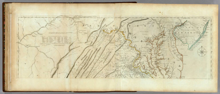
[Jefferys, Thomas, Fry, Joshua, 1700 (ca.)-1754, Jefferson, Peter, 1708-1754]
Full Title
A Map of the most Inhabited part of Virginia containing the whole province of Maryland with Part of Pensilvania, New Jersey and North Carolina. Drawn by Joshua Fry & Peter Jefferson in 1775. Printed for Robt. Sayer ... London. (Northern Section)
List No
0346.023
Note
Map in two sections this being the northern one. Distances and directions shown on chart derived by J. Dalrymple in 1755. Map in outline color by state. Title cartouche on lower half.
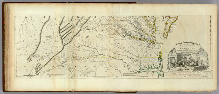
Author
[Jefferys, Thomas, Fry, Joshua, 1700 (ca.)-1754, Jefferson, Peter, 1708-1754]
Full Title
A Map of the most Inhabited part of Virginia containing the whole province of Maryland with Part of Pensilvania, New Jersey and North Carolina. Drawn by Joshua Fry & Peter Jefferson in 1775. Printed for Robt. Sayer ... London. (Southern Section)
List No
0346.024
Note
Southern section in outline color and containing title cartouche. Note below cartouche states: "To the Right Honourable, George Dunk Earl of Halifax First Lord Commissioner; and to the Rest of the Right Honourable and Honourable Commissioners, for Trade and Plantations. This Map is most humbly Inscribed to their Lordships, By their Lordship's Most Obedient & most devoted humble Servt. Thos. Jefferys." Survey lines are noted and explained. In outline color by state.
Author
[Jefferys, Thomas, Fry, Joshua, 1700 (ca.)-1754, Jefferson, Peter, 1708-1754]
Full Title
(Composite of) A Map of the most Inhabited part of Virginia containing the whole province of Maryland with Part of Pensilvania, New Jersey and North Carolina. Drawn by Joshua Fry & Peter Jefferson in 1775. Printed for Robt. Sayer ... London.
List No
0346.025
Note
Distances and directions shown on chart derived by J. Dalrymple in 1755. Note below cartouche states: "To the Right Honourable, George Dunk Earl of Halifax First Lord Commissioner; and to the Rest of the Right Honourable and Honourable Commissioners, for Trade and Plantations. This Map is most humbly Inscribed to their Lordships, By their Lordship's Most Obedient & most devoted humble Servt. Thos. Jefferys." Survey lines are noted and explained. In outline color by state.
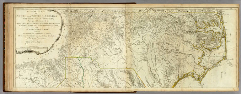
Author
[Jefferys, Thomas, Mouzon, Henry]
Full Title
An Accurate Map Of North And South Carolina With Their Indian Frontiers, Shewing in a distinct manner all the Mountains, Rivers, Swamps, Marshes, Bays, Creeks, Harbours, Sandbanks and Soundings on the Coasts; with The Roads and Indian Paths; as well as The Boundary or Provincial Lines, The Several Townships and other divisions of the Land In Both The Provinces; the whole From Actual Surveys By Henry Mouzon And Others. London. Printed for Robt. Sayer and J. Bennett ... May 30th 1775. (Northern Section)
List No
0346.026
Note
In outline color by state. In two sections with this being the northernmost. Large title cartouche at upper left.
Author
[Jefferys, Thomas, Mouzon, Henry]
Full Title
(Composite of) An Accurate Map Of North And South Carolina With Their Indian Frontiers, Shewing in a distinct manner all the Mountains, Rivers, Swamps, Marshes, Bays, Creeks, Harbours, Sandbanks and Soundings on the Coasts; with The Roads and Indian Paths; as well as The Boundary or Provincial Lines, The Several Townships and other divisions of the Land In Both The Provinces; the whole From Actual Surveys By Henry Mouzon And Others. London. Printed for Robt. Sayer and J. Bennett ... May 30th 1775.
List No
0346.028
Note
In outline color by state.
Author
Mitchell, Samuel Augustus
Full Title
A New Map Of Nth. Carolina With Its Canals, Roads & Distances from place to place, along the Stage & Steam Boat Routes. (with) two inset maps: the Newbern region and the Gold Region. Published By S. Augustus Mitchell, N.E. corner of Market & 7th Street Philada., 1846. Entered ... 1846 by H.N. Burroughs ... Pennsylvania.
List No
0537.019
Note
Full color by county with table of distances and profile of the Dismal Swamp Canal.
Author
Mitchell, Samuel Augustus
Full Title
Map of the Middle States. Engraved to Illustrate Mitchell's School and Family Geography. No. 7. Engraved by J.H. Young. Entered ... 1839, by S. Augustus Mitchell ... Connecticut.
List No
0523.005
Note
In full color by state. Includes explanation of symbols used to represent towns, railroads, canals and distance.
Author
Marshall, John
Full Title
Theatre des Operations les plus importantes de l'Armee du Sud, dans la Virginie, dans les deux Carolines, et dans la Georgie. (1807)
List No
0462.011
Note
Engraved. Folded map. Relief shown by hachures.
Author
Marshall, John
Full Title
Carte des Provinces Meridionales des Etats-Unis. (1807)
List No
0462.002
Note
Fold-out map. Relief shown by sketches. Meridian Paris. Engraved.
1-25 of 25
|