Author
Callot, Jacques (1592-1635)
Full Title
(The Siege of the Citadel of Saint Martin on the Isle de Re)
List No
8685.000
Note
These are a set of six prints illustrating the Siege of the Citadel of Saint Martin on the Isle de Re. Callot also engraved the Seige of La Rochelle at the same time, also in six prints with decorative borders (Lieure 655). Both are remarkable, but the Seige of Saint Martin view is extraordinary in its use of engraving line darkness to indicate depth of space, a technique that Callot pioneered. These famous battle scenes were drawn and etched by Callot as bird's-eye views and maps. Callot received commissions to commemorate these two spectacular battle scenes from Louis XIII in 1628. The Siege of La Rochelle and St. Martin on the L'Ile de Re took place between the French Royal forces of Louis XIII and the Huguenots of La Rochelle and the English forces of Charles I at St. Martin in the years 1625-1628. The Siege of Saint-Martin-de-Ré, occurred in the French isle of Ile de Ré around the fortress of the city of Saint-Martin-de-Ré, when Duke of Buckingham tried to occupy the island in 1627. After three months of combat and sieges however, Governor Toiras and a relief force of French ships and troops managed to repel the Duke of Buckingham, who was forced to withdraw in defeat. This encounter followed another defeat for Buckingham, the 1625 Cádiz Expedition, and is considered as the opening conflict of the Anglo-French War of 1627-1629, itself a part of the Thirty Years' War.
Author
Weigel, Christoph
Full Title
Discus Cronologicus Omnium S.R.I.Electorum a fine magni illius et fatalis in Germaia interregni per auspicatam electionem Rudolfi I. Habsburgici in Regem Germaniae et Romanum Imperatorem usque ad nostra tempora.
List No
11175.000
Note
Circular historical diagram with movable paper hand, dial is arranged in concentric circles, each circle corresponding to one electorship; hand moves chronologically from 1200 to 1800. The chart provides a chronology of rulers within the German Empire from 1200 to 1800 - with the chart remaining blank after 1716. There are 10 concentric rings, each representing a different kingdom or sphere of influence, such as Holy Roman Emperor, King of Bohemia, King of Saxony, etc. The circle is divided into 6 centuries, with each century spanning 60 degrees. The names of the rulers are listed within each ring, and placed at the corresponding degree based on the year they came to power. The spheres of influence are also listed on the pointer, so that the pointer can be moved around the circle to any date to see the names of the noblemen on that date. Includes cherubs hold the drape style title at top and explanatory text at bottom. Title and chart in Latin; explanatory text in German. Date estimated.
Author
[Munster, Sebastian, 1448–1552, Ptolemy, Claudius, Pirckheimer, Willibald, 1470-1530]
Full Title
Typus Orbis Universalis. (to accompany) Geographia universalis, vetus et nova, complectens Claudii Ptolemaei Alexandrini enarrationis libros VIII ... Basileae apud Henricum Petrum Mense Martio anno M.D. XL (1540).
List No
11623.009
Note
Woodcut uncolored map of the world. The first map to name the pacific Ocean “Mare Pacificum”. Shows windheads around the map sea monsters, rivers and mountains. Relief shown pictorially.
Author
[Munster, Sebastian, 1448–1552, Ptolemy, Claudius, Pirckheimer, Willibald, 1470-1530]
Full Title
Typus orbis a Ptol. descriptus. (to accompany) Geographia universalis, vetus et nova, complectens Claudii Ptolemaei Alexandrini enarrationis libros VIII ... Basileae apud Henricum Petrum Mense Martio anno M.D. XL (1540).
List No
11623.011
Note
Woodcut uncolored map of the modern world and its regions. Shows windheads around the map, rivers and mountains. Relief shown pictorially. Includes notes.
Author
[Munster, Sebastian, 1448–1552, Ptolemy, Claudius, Pirckheimer, Willibald, 1470-1530]
Full Title
Novae Insulae XVII Nova Tabula. (to accompany) Geographia universalis, vetus et nozva, complectens Claudii Ptolemaei Alexandrini enarrationis libros VIII ... Basileae apud Henricum Petrum Mense Martio anno M.D. XL (1540).
List No
11623.100
Note
Woodcut uncolored map of the New World, the first edition of map of the continent of America, and the earliest map to show all of North and South America in a continental form. It is the first to name the Pacific Ocean (Mare Pacificum) and the Straits of Magellan, with his ship Victoria in the Pacific. Shows The flags of Spain (on Puerto Rico), place names, rivers and mountains. Relief shown pictorially. Included notes.
Author
[Bachelder, John Badger, 1825-1894, Warren, G.K., Humphreys, A. A.]
Full Title
Map of the battle field of Gettysburg, July 1st, 2nd, 3rd 1863. First day battle. Published by authority of the Hon. the Secretary of War, Office of the Chief of Engineers U.S. Army. 1876. Positions of troops compiled and added for the government by John B. Bachelder. Topography engraved by Julius Bien, 16 Park Place N. Y. Position & lettering by Louis E. Newman, 36 Vesey St., N.Y. Printed by Endicott & Co., New York.
List No
11605.001
Note
First map of the battle field of Gettysburg, July 1st, 1863. Relief shown by contours, form lines and spot heights. Scale:1:12,000. 1 in. represents 1000 ft. Shows Gettysburg environs, place names, the position of the troops by color and signal stations Includes notes. "The survey was ordered by Brevet Major General A.A. Humphreys, Chief of Engineers, and conducted under Brevet Major General G.K. Warren, Major of Engineers."
Author
[Bachelder, John Badger, 1825-1894, Warren, G.K., Humphreys, A. A.]
Full Title
Map of the battle field of Gettysburg, July 1st, 2nd, 3rd 1863. First day battle. Published by authority of the Hon. the Secretary of War, Office of the Chief of Engineers U.S. Army. 1876. Positions of troops compiled and added for the government by John B. Bachelder. Topography engraved by Julius Bien, 16 Park Place N. Y. Position & lettering by Louis E. Newman, 36 Vesey St., N.Y. Printed by Endicott & Co., New York.
List No
11605.002
Note
Second map of the battle field of Gettysburg, July 2nd, 1963. Relief shown by contours, form lines and spot heights. Scale:1:12,000. 1 in. represents 1000 ft. Shows Gettysburg environs, place names, the position of the troops by color and signal stations Includes notes. "The survey was ordered by Brevet Major General A.A. Humphreys, Chief of Engineers, and conducted under Brevet Major General G.K. Warren, Major of Engineers."
Author
[Bachelder, John Badger, 1825-1894, Warren, G.K., Humphreys, A. A.]
Full Title
Map of the battle field of Gettysburg, July 1st, 2nd, 3rd 1863. First day battle. Published by authority of the Hon. the Secretary of War, Office of the Chief of Engineers U.S. Army. 1876. Positions of troops compiled and added for the government by John B. Bachelder. Topography engraved by Julius Bien, 16 Park Place N. Y. Position & lettering by Louis E. Newman, 36 Vesey St., N.Y. Printed by Endicott & Co., New York.
List No
11605.003
Note
Third map of the battle field of Gettysburg, July 3rd, 1963. Relief shown by contours, form lines and spot heights. Scale:1:12,000. 1 in. represents 1000 ft. Shows Gettysburg environs, place names, the posi+tion of the troops by color and signal stations Includes notes. "The survey was ordered by Brevet Major General A.A. Humphreys, Chief of Engineers, and conducted under Brevet Major General G.K. Warren, Major of Engineers."
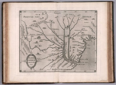
Author
[Wytfliet, Corneille, Magini, Giovanni Antonio]
Full Title
Plata Americae provincia. (to accompany) Histoire universelle des Indes occidentales et orientales, et de la conversion des Indiens : divisee en trois parties par Cornille Wytfliet & Anthoine Magin & autres historiens. Premiere Partie. A Douay, Chez Francois Fabri, l'An 1611.
List No
11622.020
Note
Uncolored engraved double page map of the Rio de la Plata region. Covers Argentina, Uruguay and the southern part of Brazil. Shows cities, towns, landmarks, rivers, capes, bays and mountains. Relief shown pictorially. Includes decorative title cartouche.
Author
Shurtleff, Elizabeth
Full Title
Star Map. Face South, And Raise Map Over Head, To Place Constellations.Guide to Star Magnitudes.
List No
10097.000
Note
Date estimated. A pictorial celestial map. Instructions under the title explain how to hold the map to identify the constellations in the night sky. With strong colors in the style of other Shurtleff pictorial maps. Another edition was published by the Graphic History Association in the same year (Worldcat). A folded version was accompanied by an envelope.
Author
[Martin, R.M., Tallis, J. & F.]
Full Title
New York
List No
10095.107
Author
American Airlines Inc.
Full Title
Air Map. Route of the flagships uniting Canada, U.S.A. and Mexico. American Airlines Inc.
List No
11632.000
Note
Issued first as an advertisement, with summary of the air age, and how it applies to our world view. Mankind is no longer dependent on water or land to travel, so they are removed from the map. And what you are left with is a totally different take on who your neighbors are. Showing just city names and their approximate distance, it is a new view that would change everything. Date estimated.
Author
[Chirpe, W Rodney, Montgomery Ward Co., Inc.]
Full Title
Texas Centennial Exposition 1830-1936 : presented by Montgomery Ward. Designed by W. Rodney Chirpe. Copyright 1936 by Montgomery Ward Co., Inc.
List No
11641.000
Note
Color pictorial map of Texas, Includes historical vignettes on both sides and lower panels, historical notes and decorative compass rose oriented with the north to upper right margin. Shows landmarks, roads, farms, railroads, park, industry, agriculture, rivers, mountains and Native American settlements. Relief shown pictorially. Centennial Exposition was held at Fair Park in Dallas, to celebrate the 100th anniversary of Texas's independence from Mexico in 1836. It was also a celebration of Texas and Western culture. W. Rodney Chirpe was an artist who achieved some success in commercial and advertizing design. His work was featured in an exhibit at the Art Institute of Chicago in 1934.
Author
Yaggy, Levi Walter
Full Title
Arctic Zone.
List No
10096.005
Author
Yaggy, Levi Walter
Full Title
Geological Chart.
List No
10096.009
Author
[Woerl, Joseph Edmund (1803-1865), Herder, Bartholomew]
Full Title
(Covers to) Atlas von Central Europa : Enthaltend das Konigreich Frankreich ; die nordstl. Provinzen von Spanien, die Konigreiche der Niederlande und Belgien nebst dem Grossherzogthum Luxemburg, die Konigreiche Preussen, Hannover, Danemark, Sachsen, Bayern, Wurttemberg ... Entworfen im masstabe 1:500,000 von Dr. J.E. Woerl. Freiburg im Breisgau. Herder'sche Verlagshandlung.
List No
10094.002
Note
Atlas of Central Europe by Joseph Edmund Woerl in 60 sheets. each 45x52 or smaller, dissected into 6 sections, backed with linen, folded and placed in cardboard case 25x20, with title "Karte von Central-Europa" in gold on spine. Sheet 8 includes Title with text, inset map, and tables of population of provinces, towns and islands. Maps showing roads, railroads, cities, towns, landmarks, canals, fortifications, forests, rivers and mountains. Relief shown by hachures. Depth shown by bathymetric lines and soundings. Includes inset maps: Environs de Paris -- Plan de Strasbourg -- Plan de Lyon -- Plan de Bordeaux -- Plan de Rouen -- [Bruxelles-Louvain-Nivelles] -- Plan de Nantes -- Plan d'Orléans -- Contorni di Milano -- Planta di Firenze -- Planta topografica della città di Roma.Includes a separate index sheet "Assemblage zur Karte von Central - Europe. Masstab 1:500,000. Verlag von Herder in Freiburg I. B." Maps are the earliest of two-color lithography. As late as 1870 this atlas rendered important service to the German army, It is also an outstanding example of early lithographic map printing. Woerl seems to have pioneered a method of using color lithography, he used a red lithographic stone for a second overlay printing and may have used a unique combination of lithography and engraving to produce these maps. Imprint of some maps are in French. Library lacks sheets 26 and 59.
Author
[Vignelli Associates, Vignelli, Massimo (1931-2014)]
Full Title
New York City Subway Diagram, 2012.
List No
12364.000
Note
Schematic of the New York City subway system. A later edition of the iconic 1972 map (see our 9891.000).
Author
Allard, Carel, 1648-1709
Full Title
Planisphaerium terrestre, sive terrarum orbis, planisphaericè constructi repraesentatio quintuplex : adjunctis aliquibus astronomicae geographiae tyrociniis. Auctore Carolo Allard, Amstelo-Batavo = Vlakke aard-kloot, gemeenlyk genaamd de geheele waereld, vysvoudiglyk in vlakke ronden verbeeld : mitsgaders eenige noodige ontwerpen des sterrekundigen aard-beschryvings : Door Carel Allard, tot Amsterdam.
List No
11606.000
Note
One of the earliest multiple hemispheric maps of the world, surrounded by 12 insets, eight smaller projections depicting the world from various orientations, and four smaller circular diagrams of hemispheric projections. Shows California as an Island, "Terra Esonis" stretching between North America and Asia, partial coastlines for New Zealand and Australia together with the coastlines of "Carpentaria" and "Quiri Regio". Allard's innovative scientific style was copied by a number of other mapmakers, including Schenk, Zurner, Homann and Seutter, replacing the traditional baroque ornamentation of the late Dutch period. The dark cross-hatched engraved background provides a striking contrast to the engraved maps. Includes two title cartouches, one in Latin with the other in Dutch.
Author
Wisner de Morgenstern, Francois, 1804-1878
Full Title
(Composite Map) Carte Topographique de la Republique du Paraguay. Carte originale vaite de 1846 a 1858 par des procedees triganometriques et astronomiques dedie au honorable Congres Legilative de la Nation par le Colonel du Genie Francois Wisner de Morgenstern . . . 1873.
List No
12362.003
Author
[Lindgren Brothers, Lindgren, Jolly]
Full Title
A Hysterical Map of Mount Rainier National Park. Year Around Public Playground. High White and Handsome.
List No
12319.000
Note
Colorful and humorous.
Author
Boschke, Albert
Full Title
Map of Washington City, District of Columbia. Seat of the Federal Government. Respectfully Dedicated to the Senate and the House of Representatives of the United States of North America. Surveyed and published by A. Boschke, C.E. 1857.
List No
12363.000
Author
[Zatta, Antonio, active 1757-1797, Zuliani, Gianantonio, Pitteri, Giovanni Marco]
Full Title
Planisferio Celeste Settentrionale Tagliato Sull' Equatore. Venezia 1777. Presso Antonio Zatta ... G. Zuliani scolp. G. Pitteri scri. (to accompany) Atlante novissimo Tomo I. Venezia. MDCCLXXIX (1779). Con privilegio dell Eccelimo Senato. (tomo I-IV).
List No
11598.038
Note
Engraved hand-colored in outline, double-page circular celestial map of the northern skies, showing astrological figures in outline, different stars and constellations, their relative brightness. Includes in each corner, vignette views of the observatories at Pisa, Bologna, Padova and Milan.
Author
[Deharme, Louis-François, Desnos, Louis-Charles]
Full Title
(Composite Map of) Map sheets 1-35 and index sheets.
List No
12243.047
Author
Roussel, capitaine, -1733
Full Title
(Composite map) Paris ses fauxbourgs et ses environs ou se trouve le detail des villages, chateaux, grands chemins, pavez et autres des hauteurs, bois, vignes, terres et prez, levez Geometriquement. Par le Sr. Roussel Capne Ingenieur. Revu et augmente l'an IV. de la Republique Francaise.Atlas du canton de Paris, divise en ses XII municipalites avec ses environs, leve geometriquement a la plus grande echelle : revu et augmente l'an 4eme.
List No
11609.012
Note
Composite map: Sheets 1-9 of Paris ses faux bourgs et ses environs ou se trouve le detail des villages ...
Author
[Linschoten, Jan Huygen van, 1563-1611, Paludanus, Bernard, 1550-1633, Plancius, Petro, Doetecum, Jan van]
Full Title
Orbis Terrarum Typus de Integro Multis in Locis Emendatus. Carte generale de tout l'Unevers.
List No
12236.008
Note
Foldout. This map is among the first world maps to use highly decorated borders, setting a style of world maps that would continue for the next century.
Author
[Linschoten, Jan Huygen van, 1563-1611, Paludanus, Bernard, 1550-1633]
Full Title
(Southwest Asia). Definiantur in hac tabula, Orae maritimae Abexie, freri Mecani al Maris Rubri Arabiae .... Carte de la coste des Indes depuis la Mer Rouge, Jusques a Bengala.
List No
12236.011
Note
Date estimated. Foldout. Linschoten's map of India and the middle east was a significant advance over other maps of the period - it is one of the first maps to accurately delineate India and Arabia.
Author
[Linschoten, Jan Huygen van, 1563-1611, Paludanus, Bernard, 1550-1633, Langren, Arnold van]
Full Title
(South America and West Indies.) Delineatio omnium orarum totius Australis partis Americae ....
List No
12236.013
Note
Date estimated. Foldout. "An extraordinary map of South America, the Caribbean islands, and Florida, shown on a horizontal axis. This is one of the most striking and decorative maps of South America and is an important early record of the continent. The map is oriented with north to the right and includes Florida and the Gulf Coast (over 20 place names shown), and the Caribbean. The Straits of Magellan are depicted, with Terra del Fuego shown as a part of the great southern land mass. The coastlines are well defined and densely engraved with place names while the interior is filled with fictional mountains, rivers and vignettes of Patagonian giants, Brazilian cannibals and numerous strange animals including a lion-like creature with a striped tail and human face. Other embellishments include large elaborate cartouches, sea monsters, galleons and a beautiful compass rose. " (Ruderman)
Author
[Linschoten, Jan Huygen van, 1563-1611, Paludanus, Bernard, 1550-1633]
Full Title
(Title Page) Histoire de la navigation de Jean Hugues de Linschot Hollandois, aux Indes Orientales, contenant diverses descriptions des lieux jusques à présent descouverts par les Portugais, observations des coustumes et singularitez de delà et autres déclarations, avec annotations de B. Paludanus,... sur la matière des plantes et espiceries, item quelques cartes géographiques et autres figures. Troixiesme édition augmentéee ... A Amsterdam. Chez Evert Cloppenburgh ... 1638.
List No
12236.002
Author
[Linschoten, Jan Huygen van, 1563-1611, Paludanus, Bernard, 1550-1633]
Full Title
(View) Navire de Portugais & de Malabares.
List No
12236.064
Author
Sanson, Nicolas, 1600-1667
Full Title
Americque Septentrionale. Par le Sr. Sanson d' Abbeville, Geographe Ordinaire du Roy ... 1657. A. Peyrouin, sculp. (to accompany) L'Amerique en plusieurs cartes, & en divers traitte's de geographie et d'histoire. A Paris chez l'Autheur.
List No
11576.008
Note
Copper engraved double page map of North America with California as an Island, hand colored in outline, with decorative cartouche, engraved by A Peyrounin. Covers all of North America from Baffin Bay and Greenland, to Central America in the south. Showing political and administrative boundaries, major cities, towns, villages, rivers, mountains, etc. Relief shown pictorially.
Author
Sanson, Nicolas, 1600-1667
Full Title
Le Canada, ou Nouvelle France &c. : tiree de diverses relations des Francois, Anglois, Hollandois, &c. Par N. Sanson d'Abbeville, Geographe ordre du Roy ... 1657. (to accompany) L'Amerique en plusieurs cartes, & en divers traitte's de geographie et d'histoire ... A Paris chez l'Autheur.
List No
11576.012
Note
Copper engraved double page map of Canada and the Great Lakes. Showing political and administrative boundaries, major cities, towns, villages, rivers, mountains, drainage, etc. Relief shown pictorially.
Author
[Ewald, Ludwig 1813-1881, Bauerkeller, Georg Leonhart]
Full Title
No. 40. Vergleichendes Profil der Berggipfel mit Bezeichnung der Schneegraenze.
List No
12189.062
Author
[Ewald, Ludwig 1813-1881, Bauerkeller, Georg Leonhart]
Full Title
No. 3. Tags und Jahreszeiten.
List No
12189.025
Author
[Ewald, Ludwig 1813-1881, Bauerkeller, Georg Leonhart]
Full Title
(Geologic Cross-Section) No. 10. Geologische Elemente.
List No
12189.032
Author
Dale, O.J.
Full Title
Pictorial map of the city and surroundings of Melbourne in the state of Victoria, Commonwea1th of Australia: depicting the principal highways, railways, parks, historic landscapes and associations together with divers amusements and customs prevailing in the "Queen City of the South", 1834-1934.
List No
10092.000
Note
Pictorial street map of Melbourne. Includes col. ills. and text on historical figures and events in side margins.
Author
[Lubin, Eilhard (1565-1621), Geelkercken, Nicolaes van]
Full Title
(Composite map) Nova illustrissimi principatus Pomeraniae descriptio cum adjuncta Principum genealogia et Principum veris et potiorum Urbium imaginibus et Nobilium insignibus. N. Geilkerckius sculpsit. [With] Pomeraniae et rerum in ea memorabilium brevis descriptio E. Lubini.
List No
11511.013
Note
Composite map of Pomerania, sheets 1-12. Large and impressive outline colored copperplate engraving map of Pomerania on 12 sheets, 42x54 or smaller, by Eilhard Lubin, Professor at the University of Rostock. In 1610 he was asked by Philipp II, the Duke of Pomerania to create a large scale map of the geography and history of the duchy. In 1612 map was completed, it was decorated with 49 town views, and coat of arms of the noble families. In 1618 the Dutch engraver Nicolas van Geelkercken, engraved the copperplates in Amsterdam, and a small number of sheets were printed. The plates disappeared in the thirty years war and were rediscovered by the historian Johann Carl Conard Oelrichs in 1758. The map shows 49 town views on the border, the family tree of the house of Griffins, dukes of Pomerania, with 157 names and small portraits, a small family tree of the house of Rugen, 5 large portraits of living dukes of different parts of Pomerania, and on the lower middle left sheet probably the portrait of Lubin himself. The map shows towns and villages, landmarks, churches, forest, rivers and mountains. Relief is shown pictorially. Lubin's Pomerania remained the most accurate map of the region from its inception in 1618 until the Prussian topographical survey of the eighteenth century. The map is extraordinary in the way that it combines the "mapping" of the history of the ruling families with the mapping of the topography of Pomerania.
Author
[Ogilby, John, 1600-1676, Montanus, Arnoldus, 1625?-1683]
Full Title
(Title Page (Illustrated)) America.
List No
12241.002
Author
[Ogilby, John, 1600-1676, Montanus, Arnoldus, 1625?-1683]
Full Title
Novissima et Accuratissima Totius Americae Descriptio.
List No
12241.008
Note
Foldout.
Author
[Ogilby, John, 1600-1676, Montanus, Arnoldus, 1625?-1683, Moxon, James]
Full Title
A New Description of Carolina by Order of the Lords Proprietors.
List No
12241.044
Note
North to the right. Foldout.
Author
[Ogilby, John, 1600-1676, Montanus, Arnoldus, 1625?-1683]
Full Title
Vetus Mexico.
List No
12241.026
Author
[Ogilby, John, 1600-1676, Montanus, Arnoldus, 1625?-1683]
Full Title
(View) "Llama (says he) a four-footed Creature, furnishes its Master with Meat and Clothing, and supplies the office of a Beast of Burthens".
List No
12241.011
Author
[Humboldt, Alexander von, 1769-1859, Bonpland, Aime, Marchais, L., de Buch, Leopold, Smith, Chr.]
Full Title
II. Tableau physique des iles Canaries. Geographie des plantes du Pic de Teneriffe.
List No
12125.024
Author
[Humboldt, Alexander von, 1769-1859, Bonpland, Aime, Marchais, F., Kunth, Montufar, Carlos]
Full Title
IX. Voyage vers la cime du Chimborazo, tenete le 24 juin 1802. Geographie des plantes dans les Andes de Quito.
List No
12125.031
Author
Hallwag AG.
Full Title
Mars Marte : North Pole. Meridian 0 (degree). South Pole. Meridian 120 (Degree). Meridian 240 (Degree). (cover title) Mars Marte. Der rote Planet. The red planet. la planete rouge. Il pianeta rosso. Hallwag Verlag. Bern. Hallwag Publishers.
List No
11524.003
Note
5 color detailed map of Mars on 1 sheet; 34 and 19 diameter, sheet 84 x 98, folded into slipcase, 22x16.5. With notes and 2 inset views of the planet. Relief shown by shadings. Shows place names. Map was made in the first year of the Viking program, when NASA sent two spacecrafts, Viking 1 and Viking 2, to Mars in order to make new photographic survey of the planet. The operation lasted from 1975 to 1980. Viking 2 worked until 1978. Relief shown by shading. In German, English, French and Italian. On verso: Text, maps, diagrams, and illustration of Exploration of the planet Mars.
Author
[Texeira, Pedro, Saury, Salomon]
Full Title
(Composite map) Topographia de la villa de Madrid descrita por Don Pedro Texeira Ano 1656. Madrid 1943 (MCMXLIII). (map title) Mantua Carpetanorvm, sive Matritvni vrbs regia. educion hecha por el Instituto Geographico y Catastral, por Victor Garcia, Caligrafo, y por Artes Graficas Municipales ...
List No
11229.026
Note
Facsimile reprint edition of topographic plan of Madrid in 20 sheets, 188x290, which together form an impressive mural, published in 1943 by Geographical and Cadastral Institue. Originally published 1656 by Pedro Teixeira Albernaz ( Lisbon ,1595- Madrid , 1662), Portuguese cartographer who worked commissioned by Philip IV. Representing 18 churches, 55 convents and 14 hospitals and religious schools. Dedicated to "Philippo IV, Regi Catholico ..." Issued in decorated hard cover portfolio, with the shield of the Villa de Madrid. Including title cartouche decorated with the shield of Spain, dedication sheet, imprint page and index. On verso of title page: Edicion de quinientos ejemplares numerados, de los cuales se destinan a la venta doscientos cincuenta. Numeros del 101 al 350. Ejemplar numero 130.- D. Enrique Pfitz Lopez, Arquiteco." only 500 copies of which only 250 were offered to the sale ... Maps printed in black ink on white paper, showing streets, houses, major buildings, parishes, convents, hospitals, with number of floors, doors and windows, and details such as facades and roofs, also distribution of the plants. Relief shown pictorially. Includes " Original imprint: Antuerpiae [Antwerp] : Cura et solesitudine Ioannis et Iacobi van Veerle, 1656. "Salomon Saurij Fecit"--Lower right corner. Scales showing "Pitipié de Quinientas Varas Castellanas", "Pitipié de Mil Pies de Atercia de vara", and "Pitipié de Quinientos Pacos de Ados Pies y Medio." Includes index of parishes, convents, hospitals, fountains, ponds, etc. and numerical keyed to map.
Author
Lopez de Vargas Machuca, Tomas (1730-1802)
Full Title
Plano geometrico de Madrid : dedicado y presentado al rey nuestro Senor Don Carlos III por mano del excelentisimo Senor Conde de Floridablanca ... su autor Don Tomas Lopez, geografico de S.M. de las Reales Academias de la Historia, de San Fernando, de la de Bueans Letras de Sevilla y de las Sociedades Bascongada y Asturzias. Madrid ano de 1785. (to accompany) Atlas geografico de Espana ... por Don Tomas Lopez ... Tomo Primero. Ano 1810. (inset) Des de la Puerta de Toledo ...
List No
11510.129
Note
Engraved folded plan of Madrid on sheet 68x96. Shows city grid, parks, and drainage, landmarks, public buildings, roads and rivers. Relief shown by hachures. Includes descriptive text, notes and numeric key to buildings.
Author
Lopez de Vargas Machuca, Tomas (1730-1802)
Full Title
Mapa General de Espana : Dividido en sus Actuales provincias, islas adyacentes, y reyno de Portugal. compuesto con lo mejor que hay impreso, manuscrito noticias de sus naturales, y sujeto a las observaciones Astronomicas por Tomas Lopez. Madrid, Ano de 1802. Se hallara este con todas las obras del autor y las de su hijo en Madrid. Editorial, plazuela del Angel no. 19 qto. Pra. (to accompany) Atlas geografico de Espana ... por Don Tomas Lopez ... Tomo Primero. Ano 1810.
List No
11510.011
Note
Composite of sheets A-D. 1 map on 4 sheets, engraved outline hand colored, with title carthouche. Shows administrative divisions, major cities, towns, villages, landmarks, public buildings, roads, rivers, canals and mountains. Relief shown pictorially. Includes legend and notes.
Author
[Tomlinson, John, Picture Map Company]
Full Title
A bird's-eye panoramic map of San Francisco, field compiled & hand drawn; showing the Financial District, Chinatown, Russian Hill, Nob Hill, Telegraph Hill, North Beach, the Embarcadero, the Jackson Square Historic District, and an inset view of civic center. John Tomlinson. 1976, The Picture map Company... San Francisco, Ca, 94101. (inset) San Francisco Civic Center.
List No
11331.000
Note
Panoramic map of San Francisco, California, by John Tomlinson. Shows street names, ports, city blocks, businesses and prominent buildings named. Includes vignettes of buildings in upper margin and on the map. Includes index to points of interest.
Author
Krieger, Joh. Nep. (Johann Nepomuk), 1865-1902
Full Title
29. Die Riphaeen.
List No
12134.008
Author
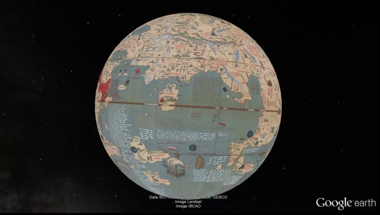
[Behaim, Martin, 1459-1507, Ravenstein, Ernest George, 1834-1913]
Full Title
Video: Martin Behaim's Erdapfel, 1492, in Google Earth. (Facsimile of Behaim's Globe).
List No
12237.026
Note
Video of georeferenced globe gores in Google Earth. 12 Gores and 2 Polar Calottes, Date of original.
|