Author
Scheuerle, Joe (1873-1948)
Full Title
(Covers to) Great Northern Recreational Map of Glacier National Park Montana, Waterton Lakes National Park Alberta.
List No
6782.001
Note
Date estimated. Cover title: "Vacations for All, Great Northern, Glacier National Park, Waterton Lakes Park."
Author
Lindgren, Jolly
Full Title
A Hysterical Map of Death Valley National Monument and It's Lookin' Mighty Low.
List No
6786.002
Author
Chase, Ernest Dudley, 1878-1966
Full Title
A Pictorial Map of the New England States U.S.A. Designed and Drawn by Ernest Dudley Chase of Winchester, Mass.
List No
6797.000
Note
Innumerable vignettes of structures, ships, activities, and scenery.
Author
Atwood, Mary Hall
Full Title
Los Angeles County. Long Beach.
List No
7850.003
Note
Two adjacent maps show scenes and provide descriptive text. Included are three small strip maps of the coastline and interior routes.
Author
Cressy, Mike
Full Title
The Literary Map of Latin America.
List No
7852.002
Author
Geographical Publishing Company
Full Title
(Map of the Entire World in One Hemisphere). (Portraits) (World Leaders).
List No
7907.004
Note
Flags shown with portraits of each world leader. Portrait photographs copyrighted by Underwood and Underwood, and by International Film Service.
Author
Geographical Publishing Company
Full Title
(View) The Geographical Publishing Company's Presidential Wall Atlas ... Chicago, Illinois. Interesting Facts Regarding your Flag.
List No
7907.001
Note
An elaborate poster of United States with portraits of all the presidents through Herbert Hoover, photos of noteworthy buildings, a commentary about the American flag and illustrations of the great seals of each of the states.
Author
Schmidt Litho. Co.
Full Title
Pictorial Map of Fresno County and Mid-California's Garden of the Sun. Schmidt Litho. Co. Fresno & S.F. (on verso: cover title and) Automobile Road Map of Fresno County, Yosemite Valley, Huntington Lake, General Grant National Park, Sequoia National Park. Map of Fresno County : Showing principal automobile roads. Routes and Map Bureau , California State Automobile Association. 1678 Van Ness Ave. San Francisco. Schmidt Litho. Co. Fresno & S.F. Published by Fresno County Chamber of Commerce. Fresno, California.
List No
8069.004
Note
Full color bird's eye view of Fresno county, folded into self wrappers pictorial covers 25x11, with mailer on one side showing postage 2 cents, which helps date this piece. First class postage in the U.S. was set at 2 cents in 1919 and raised to 3 cents in 1932. The map contains a large art deco title cartouche and is bordered by more than 30 black and white photo illustrations and color vignettes of important local landscapes, architecture and areas of industry and agriculture such as Yosemite National Park, Orange Grove, Typical Homes and Artesian Wells, Oil Fields, etc. Covering the areas of San Joaquin, Stanislaus, Merced, Madera, Fresno, Tulare, Kings and Kern, is bordered by The map extends to include San Francisco and its bay. On verso: text and Automobile Road Map of Fresno County, Yosemite Valley, Huntington Lake, General Grant National Park, Sequoia National Park, Scale 1:506,880.
Author
Lindgren Brothers
Full Title
A Hysterical Map Of The Yellowstone Park And The Jackson Hole Country. Slightly Cockeyed. Drawn in Broken English by Jolly Lindgren.
List No
8070.000
Note
A Pictorial humorous map is full of puns and comic vignettes related to Yellowstone and environs. Relief shown pictorially.Title printed around border. Date estimated.
Author
Sarg, Tony (1880-1942)
Full Title
Residential Main St. Nantucket Mass. Designed by Tony Sarg. 1937.
List No
8074.000
Note
Pictorial map, bird's eye view style, uncolored. By illustrator and puppeteer Tony Sarg, and this is his affectionate map of the central streets, documenting the history of this whaling town. With a list of important public and residential buildings. Includes vignette illustrations in the border of outstanding citizens. Title framed with decorative illustrations.
Author
White, Ruth Taylor
Full Title
Wine Map of California. Published by the Wine Advisory Board, San Francisco. Limned by Ruth Taylor (White).
List No
8517.000
Note
Date estimated. Shows the wine making communities of Sonoma - Mendocino, Napa Valley - Solano, Alameda - Contra Costa, Lodi - Sacramento, Santa Clara - San Benito - Santa Cruz, Modesto - Escalon, Fresno - San Joaquin Valley - Kern, Southern California. The unusual feature is the addition of two paper labels identical in design to the printed labels. The "Fresno - San Joaquin Valley - Kern" label is a correction to the name on the map itself (adding 'Kern'); the other label "Modesto Escalon" labels a previously unidentified area. There is a decorative inset at lower left which lists "The Wine-Making Towns of California." The decorative border features quotes about wine. Colored vignettes in wine growing regions; otherwise in brown.
Author
Bollmann, Hermann (1911-1971)
Full Title
New York (City) Picture Map.
List No
8532.004
Note
Date estimated. A 3-D map of Mid-town Manhattan. Highly accurate and detailed, the map is also labeled with important buildings and tourist destinations.
Author
Mora, Jo (1876-1947)
Full Title
The Seventeen Mile Drive.
List No
8559.000
Note
This was the second map made by Jo Mora. It was commissioned by the Del Monte Company to advertise its 17 Mile Drive area and attractions on the Monterey Peninsula. This copy is the first printing made with "This Map by Jo Mora" in the lower left margin. A second printing made in 1928-1929 included a copyright notice by The Del Monte Properties Co. in the lower right margin. For more information on Jo Mora's life and works, see http://www.jomoratrust.com
Author
Mora, Jo (1876-1947)
Full Title
California. This whimsical Carte of Topographic and Historic intention... A devoted adopted son made it. Jo Mora. Copyrighted MCMXXVII by A.M. Robertson, California Publisher Since 1870. San Francisco.
List No
8560.000
Note
Color pictographic map, with decorative border. Jo Mora's first map of California (see his second California map of 1945, our 6380.000. For more information on Jo Mora's life and works, see http://www.jomoratrust.com
Author
Clegg, Ernest
Full Title
Oxfordshire. Designed and drawn by Ernest Clegg. The Countryman County Maps of Britain. Copyright by the Countryman Ltd., London, England. Devised by Donald McCullough, Reproduced and printed by John Waddington Limited, Leeds, England, 1947. "Overseas edition issued for The British Travel Association".
List No
8611.000
Note
Pictorial map, with title cartouche features a panorama of the city of Oxford. Shows points of interest and city coats of arms in very high detail, agricultural and resources, including "Fat Cattle" and "Beech Timber for Chair Making". Map is surrounded by a variety of vignettes, including Christ Church Cathedral (Oxford), Blenheim Palace, Broughton Castle, Radcliffe Camera (Oxford University), and Ditchley House. Inset, includes the coat of arms of Sir Winston Churchill, Oxfordshire's most famous son, and the lines of his famous speech to the U.S. Congress, given on December 26, 1941. Also includes numerous notes on historical events and the great contribution that Oxfordshire made to the recent war effort. "Dedicated by kind permission to Sir A.P. Herbert, M.P." The map was part of series of county maps designed by Ernest Clegg, published in 1947 as the Countryman County Maps of Britain.
Author
[Beck, Henry Charles, London Transport]
Full Title
Map of London's Underground Railways. Underground. A new design for an old map. We should welcome your comments. Please write to Publicity Manager, 55, Broadway, Westminster, S.W.1 Waterlow & Sons Limited, London, Dunstable & Watford. (750M - 1-33)
List No
8691.003
Note
This the first edition of the first year of issue of Beck's famous map of the London Underground railways, the first such map to use an entirely schematic and largely non geographical design for the railway system. This map is considered to be a landmark of twentieth century information design. See our 8727.000 for the second edition later in 1933.
Author
Chiattone, Gabriele
Full Title
Gotthard-Bahn, Laghi di Como-Lugano & Maggiore, 1904. Gotthardbahn, Ferrovia del Gotthard. Stab. d'Arti Gradiche Chiattone; Milano.
List No
8118.000
Note
Gorgeous pictorial map of the Gotthard tunnel, with the 1904 train schedule. Printed in stone-lithography enhanced with gold color. Shows major cities. The Gotthard tunnel was opened in 1891 and was one of the longest tunnrels in Europe for decades. The trains from the North of Europe were able to cross the Swiss Alps to the lakes of Ticino and Italy. The wheel and the Hermes wings were the symbols of the transportation company.
Author
[Vischer, Edward, Cooper, J.J.]
Full Title
Panorama from the Summit of Mount Davidson, Washoe Range.
List No
8715.002
Note
Unusual 360 degree perspective bird's eye view as seen from summit of Mount Davidson, the site of the famous Comstock Mines and Virginia City in Nevada. Attractive vignettes of mining camps.
Author
[Moholy-Nagy, Laszlo, Imperial Airways Ltd.]
Full Title
Imperial Airways Map of Empire & European Air Routes. ... Published by Imperial Airways Ltd. I A/P/61-1M 4/37.
List No
8717.000
Note
This extraordinary world map by noted Bauhaus designer and artist, Laszlo Moholy-Nagy, draws on the pioneering information design work of Harry Beck and his London subway maps, here used to show the routes of Imperial Airways and associated airlines. What is special about the map is the combining of the more standard world map with air routes shown, with the abstract version in Beck's style of the entire route system, in an overlaid diagram floating above the Americas and the southern Pacific ocean. To further complicate the design, Moholy-Nagy uses Stanford maps with their more standard map conventions to delineate the countries that made up the British empire in 1937. The remainder of the world is left abstract. This is a very unusual map and very rare. Moholy-Nagy's name is not printed on the map, but the attribution comes from Borchardt-Hume, "Albers and Moholy-Nagy: From the Bauhaus to the New World," 2006 Tate Publications, London. Clearly shows the British Empire and air routes. Inset shows frequency of service and miles from London for Europe, Africa, Asia and Australia/New Zealand.
Author
Gill, Leslie MacDonald, 1884-1947
Full Title
Post office radio - telephone services. MacDonald Gill, 1935. P.R.D. 98.
List No
8176.000
Note
Colorful world map of international Radio Telephone Services in 1935 from London for Europe, Africa, Asia, Australia and New Zealand. On upper corners, shows long waves and short wave receiver and transfer. On lower margin: five vignettes showing Rugby Radio Station, R.R.S. Main power house, Faraday Building, London Post Office, R.R.S. Aerial tuning inductance, and R.R.S. Demountable valve. Includes mail ships, GPO logo, notes and quotes from Tennyson, Shakespeare and Ovid.
Author
[Gill, Leslie MacDonald, 1884-1947, Great Britain. Royal Mail]
Full Title
Mail steamship routes. MacDonald Gill, 1937. P.R.D. 182.
List No
8175.000
Note
Colorful world map depicts the Mail steamship routes that carried the majority of the UK’s international mail during the 1930s. Commissioned by the General Post Office in 1937. Framed by illustrations of the transport links through which the post would pass. A series of eleven vignettes showing postal and maritime history, the development of sailing vessels from the time of King Alfred to the RMS Queen Mary. Includes new redesign of GPO logo by MacDonald Gill.
Author
Burckardt's Nachf
Full Title
Der Ausbruch des Vulkans Mont Pelée auf Martinique. Druok u. Verlag v. C. Buckardt's Nachf Weissenburg (Elsass.) (inset) Martinique. (on upper right margin) No. 1794.
List No
8125.000
Note
Colorful pictorial map depicts one of the great natural disasters of the modern era, the spectacular eruption of Mount Pelee in Martinique in April 1902. on sheet 34x43. Date estimated. Includes notes. The stratovolcano of Mount Pelee makes up the northern part of the island of Martinique, long a French colony. The island's largest town, St. Pierre, sat near the foot of the volcano. As shown in the present print, the volcano violently erupted, with ash and lava flows reigning down on the town. St. Pierre and much of the surrounding countryside were engulfed and the entire town was destroyed. Over 30,000 people were killed, making it the most deadly volcanic eruption of the 20th Century.
Author
Wellge, Henry
Full Title
Yellowstone National Park. Copyright 1904 by Henry Wellge, Milwaukee. Transferred to the Northern Pacific Railway Company.
List No
8245.000
Note
Detailed bird's-eye view pictorial map. Shows labels of bodies of water, basin, cliffs, mountain ranges, and hotels. Also shows buildings, bridges, and roads. Includes the Northern Pacific Yellowstone Park Line logo. Relief shown pictorially and by spot heights.
Author
[Colomb, John Charles Ready, Crane, Walter]
Full Title
Imperial Federation - Map of the world showing the extent of the British Empire in 1886. Statistical information furnished by Captain J.C.R. Colomb, M.P. formerly R.M.A. Mclure & Co. Queen Victoria Street, London. British territories coloured in red. (Published as) Supplement to ''The Graphic'', July 24th, 1886. (Inset) Map of the world showing the extent of British territories in 1786.
List No
8238.000
Note
Pictorial map on Mercator projection centered on the Greenwich Prime Meridian, placing Great Britain just above the map's central focal point. Published as a color supplement to The "Graphic." The British Isles, and British colonies spreading out to the east and the west, were highlighted with red, while other geographical areas were left blank with only a minimum number of place names. An inset box was placed near each of the major colonies, listing statistics about geographical area, population, and trade. The words "Freedom, Fraternity, Federation," suggesting a peaceful coexistence within the British Empire, were prominently placed along the map's top margin, but the remainder of the map's illustrations imply "colonialism." At the bottom center Britannia is seated on top of the world ruling over her subjects, represented by a variety of animals and costumed figures. India, identified by an elephant and a tiger, appears in the lower left corner, while Australia, including a kangaroo and a sheep, is shown in the lower right. The illustrations were done by Walter Crane, a prominent illustrator and artist with strong socialist sympathies, perhaps explaining the contradictory themes in the map of imperialism and "human labour" holding up the world in the form of Atlas. Crane's contributions to the map remained unnoticed until the research of Pippa Biltcliffe was published in 2005.
Author
Covarrubias, Miguel (1904 - 1957)
Full Title
The Tree of Modern Art, Planted 60 Years Ago.
List No
8638.000
Note
This is a later hand drawn and painted version of Covarrubias' well known Tree of Modern Art that appeared in Vanity Fair Magazine in May of 1933. This tree is much the same, but the name of Dali has been added to the Surrealists branch, reflecting Dali's rise to prominence in the ensuring seven years. The Greek bust and the reclining man with frame are no present. The picture is signed by Covarrubias in the lower right. The date is estimated based on the verso of the paper being a blue lined base map of the National Park Service dated 12/28/39. This drawing was found in the papers of B. Ashburton Tripp (see our maps and drawing by him) and we assume that Covarrubias and Tripp were friends (verified by Tripp's descendants) and that the blue line base map was something Tripp was working on in his landscape architecture business. Possibley Covarrubias drew this for Tripp during a visit.
Author
Tripp, B. Ashburton, 1887-1955
Full Title
Cape Cod : Barnstable County Massachusetts. Designed & copyrighted 1931, B. Ashburton Tripp - Cleveland, O. Ashburton Tripp ... Publisher ... Cleveland, Ohio.
List No
8636.000
Note
Hand colored by B. Ashburton Tripp. Tripp usually produced uncolored copies of this map in strong black and white tones, but he personaly colored a few copies, as in this copy from his archive. Early pictorial map of Cape Cod, with decorative title cartouche and large compass rose. Shows towns, roads, railroad, and rivers. Bordered by illustrations of Cape Cod scenes.
Author
Anonymous
Full Title
SAS Spiral-Polar Projection. Created Especially for Scandinavian Airlines System to Illustrate Its Worldwide Routes.
List No
8976.000
Note
Date estimated.
Author
Tripp, B. Ashburton, 1887-1955
Full Title
A Map of Castilla Del Oro Panama On the Spanish Main. B. Ashburton Tripp, Cleveland O, Des et Del. Copyright 1930 B.A.T.
List No
8642.000
Note
A hand drawn and colored pictorial map of Panama, one of Tripp's most elaborate and beautiful maps - for some reason, he never published this map, although he offered it for sale in 1931 at the annual May Show at the Cleveland Museum of Art, along with all rights of publication. Tripp had a special interest in Panama and his wife, Gertrude Koehne Tripp was a former school teacher in the Canal Zone. The map has many views of important places in Panama, portraits of explorers, and a ring of figures that are described as zoomorphic images of the Chiriqui Indian Deities, surrounding the map of the country.
Author
Edwards, Emily
Full Title
Mapa de la Ciudad de Mexico y alrededores, hoy y ayer (Map of the city of Mexico and surroundings yesterday and today. Published by the Mexican Light & Power Co. Ltd. and the Mexico Tramways Company. 1932.)
List No
8979.002
Note
Unusual and elegant design incorporating Aztec symbols. Emily Edwards was a noted artist of the period.
Author
Clegg, Ernest
Full Title
The Great War Map of Battle Lines in France and Belgium on the 25th of September 1918. The exact position of the Divisions of the Allies and the Central Powers are taken from a plan compiled for the British War Records under the supervision of Field-Marshall Lord Haig. Designed and Drawn by Ernest Clegg. Copyright 1926.
List No
8669.000
Note
Printed on linen. One of Clegg's most interesting pictorial maps as well as being scarce, not in OCLC.
Author
Commission Romande de la Ligne du Simplon & Union Romande du Tourisme
Full Title
La Suisse Francaise. (French Speaking Switzerland). Edition Commission Romande de la Ligne du Simplon & Union Romande du Tourisme (Pro Lemano), Lausanne 1939.
List No
8937.000
Author
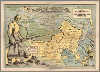
Hix, John
Full Title
Mongolia and Manchukuo : Where bloodshed marks the border between Soviet outer Maongolia and Japan's puppet Kingdom Manchukuo. A John Hix strange as it seems map presented by the Gilmore Oil Company.
List No
8354.000
Note
Color pictorial map, mounted on linen, with numerous statistical and dated explanatory text. Shows a large Russian soldier, on the left dominating the map, and small illustration of a Japanese soldier on the lower right. Shows boundaries, railroads, native people in each region, Great wall of China, Russia vessels and war planes, battle ships, and compass rose oriented to upper left margin. Relief shown pictorially. Date estimated.
Author
Ishihara, Tadashi
Full Title
Midtown Manhattan. (New York City).
List No
9082.000
Note
Ishihara incorporated three "hidden" drawings in his New York City maps: King Kong on the top of the Empire State building, American Presidents in the bird sanctuary in the south end of Central Park, and the word "Titanic" in the wake of one of the ships in the Hudson River (we are grateful to Prof. Michael Stoll for providing this information to us).
Author
[Aviation Research Associates, American Airlines Inc.]
Full Title
The Air Ocean. Prepared for American Airlines, Inc. and in collaboration with its Pilots and Air Transport Engineers, by Aviation Research Associates. Copyright 1944 by American Airlines, Inc.
List No
8662.000
Note
A fascinating map, chart, and diagram showing aspects of the earth atmosphere of importance to pilots in the early days of commercial flight.
Author
[Eddy, Isaac, Wilson, James]
Full Title
Chronology Delineated to Illustrate the History of Monarchical Revolution.
List No
8688.000
Note
Designed to make history more comprehensible and to illustrate the flow of time and events. Explanatory text at bottom of chart. Depicted as a tree with newer times higher in the tree. Obscure parts of history hidden by leaves. Two vignettes: apparently Adam in the Garden of Eden and a Native American hunting party. The ends of particular lines of civilization shown by the limb being "amputated" at the appropriate date. Lacks any reference to East Asian or New World (except United States) governments.
Author
Bollmann, Hermann (1911-1971)
Full Title
New York (City) Picture Map.
List No
3763.004
Note
Date estimated. A 3-D map of Mid-town Manhattan. Highly accurate and detailed, the map is also labeled with important buildings and tourist destinations.
Author
Gill, Leslie MacDonald, 1884-1947
Full Title
Post Office Wireless Stations.
List No
9606.000
Author
Bufford, J. H.
Full Title
War Map of the Middle States : Balloon View of Virginia, Maryland, Kentucky, Tennessee and parts of Arkansas, Missouri, Illinois, Indiana and Ohio. Boston, Lithographed and published by J.H. Bufford, 33, Washington Street. Paris & London. Published by Goupil & Co. New York. Pub: M. Knoedler, 772 Broadway.
List No
9868.000
Note
Colored rare bird’s-eye view of the theatre of conflict at the opening of the American Civil War. The view extends from Chesapeake Bay in the foreground to encompass the Appalachians and the watersheds of the Ohio and Mississippi Rivers. Shows topographical features, cities and towns, roads and railroads, and areas of elevation and waterways, in an unusual oblique view that captures a larger amount of landscape than appears in other Civil War views such as the Bachmanns (see our copies).. Relief shown by shadings. Tables in the left and right margins show distances by rail between Washington, D.C.; Cairo, Illinois; St. Louis, Missouri and other parts of the country. The map tracks the Mississippi as far south as Memphis. The whole is centered on Louisville Kentucky and the Ohio River Valley.
Author
Gill, Leslie MacDonald, 1884-1947
Full Title
The Country Bus-Services Map.
List No
9607.000
Note
Black and white. This is an artist's proof, without the colors added. The result is very striking, showing the overall design very clearly.
Author
Ortelius, Abraham, 1527-1598
Full Title
(Title page to) Theatrum Orbis Terrarum.
List No
10000.002
Note
The title page has on the verso the Epigram of 16 lines. First edition of the first atlas of the world. From Koeman: "The unique position held by Ortelius' Theatrum in the history of cartography is to be attributed primarily to its qualification as 'the world's first regularly produced atlas.' Its great commercial success 'enabled it to make so great a contribution to geographical culture throughout Europe in the later 16th century.' (Skelton). Shape and contents set the standards for later atlases, when the centre of the map-trade moved from Antwerp to Amsterdam. The characteristic feature of the Theatrum is, that it consists of two elements, forming a unitary whole: text and maps. This concept for a "Theatre of the world" was followed through the 17th century. Before Ortelius, no one and done this and thus, the chorus of praise which arose as a result of this - and the excellent text - was far from slight... Another important aspect of the Theatrum is that it was the first undertaking of its kind to reduce the best available maps to a uniform format. To that end, maps of various formats and styles had to be generalized just like the modern atlas-publisher of today would do. In selecting maps for his compilation, Ortelius was guided by his critical spirit and his encyclopaedic knowledge of maps. But Ortelius did more that the atlas-makers of today: he mentioned the names of the authors of the original maps and added a great many names of other cartographers and geographers to it... Abraham Ortelius drew all his maps in manuscript before passing them to the engravers... Ortelius stated that nearly all the plates were cut by Frans Hogenberg and his assistants." The Theatrum went through many editions in Latin, German, French, Dutch, Spanish, English, and Italian. Van der Krogt lists 37 editions, with the last edition published in 1641, long after Ortelius' death in 1598. Uncolored. Text in Latin.
Author
Ensign, Bridgman, & Fanning
Full Title
The World's in progress. Published by Ensign, Bridgman, & Fanning, 156 William Street, N.Y. Entered 1854 ... by Ensign, Bridgman, & Fanning ... New York.
List No
8024.000
Note
An unusual timeline map in the form of a pictorial rolled map of the world, with elaborate borders, attached to wooden rod. Surrounded by Universal Dial Plate Or Times Of All Nations, various vignettes with explanation of the regions, kingdoms, and countries, lists of inventions and discoveries, distribution of men, A.D. Incidents of American history, Distinguished Americans, etc.
Author
[Breese, S., Morse, Sidney E. (Sidney Edwards), 1794-1871]
Full Title
(Title Page/Contents to) Morse's Cerographic Maps. No.1. Plan Of Publication ... Each number will contain four coloured Maps ... If practicable, from two to three numbers will be issued every month ... The first ten numbers will form a comprehensive and elegant North American Atlas for the Library, the Counting House, and the School room ... Contents of No. I. Indian Territory. Northern Texas. New Mexico. Wisconsin. Michigan. Arkansas. New-York. Harper And Brothers, 82 Cliff Street. 1845 ... Price 25 Cts.
List No
4861.004
Note
1st. part of the nine original parts of four colored maps each, in illustrated printed wrappers, of Morse's North American Atlas. Each part is dated 1845, so we assume they were all issued in that year, one or two a month. The "Plan of Publication" on the front wrapper of each part calls for ten numbers, but only nine were issued. The wraps are decorated with a palm tree, fir tree, bear, giraffe, and four seals for each of the continents. The cheap price of the product is stressed: "Each number will contain four coloured Maps, the price of which will be twenty five cents, being about one fourth the cost of copper plate Maps of similar size." After publication of the parts, Morse also issued the complete atlas bound (see our #2301). This nine part issue is to be distinguished from the earlier three part issue of 32 uncolored maps as supplements to the New York Observer (see our #4180). This copy with the signature and ms index of Robert Rantoul of Beverly, Massachusetts, noted lawyer and reformer. Printed full color. This copy is folded into green cloth covered boards which slips into a quarter leather green cloth covered folio box titled "Morse's North American Atlas - 9 Original Parts - New York, 1845" in gold along the spine.
Author
Moule, Thomas
Full Title
A comparative view of some of the principal hills in Great Britain. " Hills peep o"er Hills and Alps o"er Alps arise". (by Thomas Moule).
List No
8005.000
Note
Comparative engraved view of the mountains and hills throughout Great Britain, by Thomas Moule, which appeared in Barclays Complete and Universal English Dictionary ( London: G. Virtue, 1841-1848), with Salisbury Spire, St. Paul's Cathedral and Greenwich Observatory are shown in comparison to the hills and mountain toward the center bottom, emphasizing the magnitude of nature over the achievements of mankind. Intriguingly, Ben Macdui, and not Ben Nevis, is shown as being the highest mountain in Great Britain.
Author
[Tardieu, P.A.F., Lapie, Pierre, Piquet, Chles.]
Full Title
A Map of the United States, Canada, New-Scotland, New-Brunswick and New-Foundland ... Carte Des Etats - Unis, Avec Le Canada, la Nouvelle Ecosse, le Nouveau Brunswick & Terre - Neuve. A Map of the West-Indies and the Mexican Gulph (Gulf) ...Carte Des Indes Occientale et du Golfe du Mexique... Dressee par Lapie, Capitaine-Ingenieur-Geographe. Publiee par P.A.F. Tardieu, Gravveur, Editeur-proprietaire, a Paris, Chez P.A.F. Tardieu ....
List No
6754.000
Note
Second issue of this important and rare map, first issue was in June of 1806. Drawn by Pierre Lapie, this map joins two maps that were also issued separately. Shows Michigan Territory. The Lewis and Clark mapping is not yet incorporated for the upper Missouri River area.
Author
Bollmann, Hermann (1911-1971)
Full Title
New York (City) Picture Map.
List No
3764.004
Note
Date estimated. A 3-D map of Mid-town Manhattan. Highly accurate and detailed, the map is also labeled with important buildings and tourist destinations.
Author
Chase, Ernest Dudley, 1878-1966
Full Title
Italy, with Vatican City : as drawn and published by Ernest Dudley Chase of Winchester, Massachusetts, USA. Copyright, Ernest Dudley Chase. U.S.A. (inset) Vatican City, area about 109 acres.
List No
8051.000
Note
Color pictorial map, filled with drawings of historical sites and landmarks, cities and towns, ships and boats, points of interests, and whimsical beings such as the sea monsters. Includes vignettes in margins of map and compass rose. Relief shown pictorially. The tile is framed by a decorative cartouche.
Author
Mora, Jo (1876-1947)
Full Title
Yosemite. Copyright 1931. Jo Mora.
List No
8558.000
Note
First color issue. With the automobile road in lower left not straightened out, and with the rider upper left facing right. Remarkably cute vignettes on a birdseye view of Yosemite Valley and vicinity. For more information on Jo Mora's life and works, see http://www.jomoratrust.com
Author
Mora, Jo (1876-1947)
Full Title
(Evolution of the Cowboy). Copyrighted 1933 by Jo Mora. The Jo Mora Maps - Carmel, Calif.
List No
8539.000
Note
This is the second issue of this carte, without the map of Salinas and the Monterey Peninsula on each side of the "Sweetheart of the Rodeo" image, top center. Instead it has black on yellow silhouettes of cowboys and wagon. Originally promoted by the Salinas Rodeo, this was one of Mora's most popular cartes. For more information on Jo Mora's life and works, see http://www.jomoratrust.com
Author
Allgemeiner Deutscher Automobil-Club.
Full Title
ADAC Autobahn-Karte. Masstab 1:1 500 000. (panel title) ADAC Autobahn-Karte : Karte des Allgemeinen Deutschen Automobil-Clubs, Sitz Munchen. Mit samtlichen Auffahrten, Hilfsauffahrten, Tankstellen und Rasthausern sowie dem Fernstrassennetz. Kartographisches Institut Kurt Mair/ Stuttgart. (on verso of cover) Shell X-100 Motoroel ... Shell Reisendienst. 1065045.
List No
8582.002
Note
Map shows some of the earliest depiction's of controlled access highway interchanges. Color map, 60x42 on sheet 83x44, folded into self wrapped cover, 10.5x12. Includes legend. Shows roads, gas stations, rest areas, cities and towns, distances, etc.
Author
General de Correos Seccion de Transportes.
Full Title
Carta Postal de la Republica Mexicana. Hoja No. 7. Estados de Michocan, Queretaro, Mexico, Hidalgo, Morelos, Guerrero, y D.F. (Distrito Federal). Direccion General de Correos Seccion de Transportes. Litografia de la Secretaria de Comunicaciones y Obras Publicas. Mexico.
List No
7833.009
Note
Shows primary postal routes including routes differentiated by foot, horse, car, railroad, river and sea.
|