Author
Chevalier, August
Full Title
The "Chevalier" Commercial, Pictorial and Tourist Map of San Francisco From Latest U.S. Gov. and Official Surveys. Designed-Engraved And Copyrighted By Aug. Chevalier, Lithographer Publisher, San Francisco ... copyrighted 1911 ...
List No
0140.000
Note
1st edition was 1903. A very beautiful map of San Francisco showing contour lines; all important buildings and public improvements are drawn in vignettes on the map. At the bottom of the map is the publisher's statement: "This Map is an Improved and Enlarged Edition of The Commercial Pictorial and Tourist Map of San Francisco Copyrighted Dec. 1903 by August Chevalier. Similar Maps For Other Cities in the U.S. Are Being Made." "The Exposition City 1915"
Author
Bellin, Jacques Nicolas, 1703-1772
Full Title
Le Port au Prince dans I'isle de St Domingue.
List No
6903.077
Note
Decorative title cartouche. Relief shown pictorially and by hachures. Depth shown by soundings. Shows settlements.
Author
[Instituto Geographico di Agostini, Bayer, Herbert]
Full Title
Italia Fisica. (insets) Geologia and Densita di Popolazione.
List No
2170.027
Note
Relief shown as combined hachures, shaded relief, and hypsometric tints; bathymetry also tinted.
Author
Scott, Bradford
Full Title
North America. Bradford Scott.
List No
3542.001
Note
In outline color.
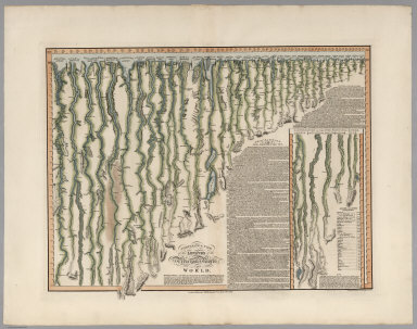
Author
Smith, C.
Full Title
Comparative View of the Lengths of the Principal Rivers in the World. London, Published by C. Smith Mapseller No. 172 Strand, Oct. 1st.1817. The Hills &c. by Palmer_The Writing by Gardner.
List No
6932.000
Note
The rivers have been necessarily straightened to indicate the lengths of the rivers. The compass orientation of the flowing stream is indicated by small north-pointing arrows periodically drawn adjacent to the stream. Includes table of the Length of Rivers in British Miles. A textual description of the rivers accompanies the illustration; it describes the course of the Missouri River, "recently explored by the Americans" (Lewis and Clark), as being "extremely devious". Beautiful color.
Author
Colton, G.W.
Full Title
(Frontispiece to) Colton's General Atlas, Containing One Hundred And Eighty Steel Plate Maps And Plans, On One Hundred And Eight Imperial Folio Sheets, Drawn By G. Woolworth Colton. Letter-Press Descriptions, Geographical, Statistical, And Historical, By Richard Swainson Fisher. New York: J.H. Colton, No. 172 William Street. London: Bacon & Co., 48 Paternoster Row. 1865. Entered ... 1863, by J.H. Colton ... New York.
List No
0151.003
Note
Vignette showing four women studying the globe surrounded by symbols of learning, time, arts, civilization, and navigation.
Author
[Abel, Henry J., Young, James H.]
Full Title
Map of the Settled Part of Wisconsin Territory compiled from the Latest Authorities by Aug. Mitchell. Philadelphia. Improved and Published by Henry J. Abel, of Wis. Ter. Compiled and Engraved by J.H. Young, Philada. 1838. (with) The Entire Territory of Wisconsin. As Established by Act of Congress. April 10, 1836.
List No
4046.001
Note
Maps in full color by county.
Author
Shell Oil Company
Full Title
Shell Map of Western and Central United States (cover title). Shell Highway Map of Western United States. 11-Y-1951-1.
List No
5840.005
Note
Includes information on travel in Canada and Mexico.
Full Title
Fig. 1 and 1a. Crotalus pyrrhus. Cope. T. Sinclair & Son lith., Phila. (1875)
List No
2220.186
Note
Color lithographed drawing of snake.
Author
Andrews, A.H. & Co.
Full Title
Andrews Eight Inch Terrestrial Globe with the latest discoveries and Oceanic currents. A.H. Andrews & Co. Chicago, Ill.
List No
5517.000
Note
This eight inch globe is shown in full color with the continental United States shown separately and Alaska named as such. With a three -footed base and a horizon ring that includes the Zodiac signs and a calendar. Total height of base and globe is 15 inches. Date is estimated from Warner.
Author
[Bishop, F. M., De Motte, B. C., Geological and Geographical Survey of the Territories (U.S.), Powell, John Wesley, 1834-1902, Thompson, A. H. (Almon Harris), 1839-1906]
Full Title
Green River from the Union Pacific Rail Road to the mouth of White River, 1873 (geology). Department of the Interior. U.S. Geological and Geographical Survey of the Territories. Second Division. J.W. Powell, geologist in charge, A.H. Thompson, geographer, B.C. De Motte & F.M. Bishop, topographers. W.H. Graves del. Outlines engraved by S.J. Kubel. U.S. G. and G. Survey, 2d. Div. ... Geology of the Unita Mountains. (Julius Bien Lith.)
List No
2078.002
Note
Colored lithographed map. Relief shown by contours, spot heights and hachures. Shows distribution of 20 sedimentary groups and one eruptive rock Trachyte.
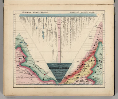
Author
Schonberg & Co.
Full Title
The Principal Mountains and Rivers of the World compiled from the Latest Authorities. New York. Schonberg & Co. 1864.
List No
4324.004
Note
Shows lengths of major rivers and heights of mountains; differentiated by hemisphere.
Author
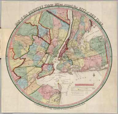
Eddy, John H.
Full Title
Map Of The Country Thirty Miles Round the City of New York. Designed & Drawn by I.H. Eddy of N. York, 1812. To Dewitt Clinton Esqr. Mayor of the City of New York This Map is inscribed by his respectful friend The Author. Published by Prior & Dunning, Map & Chart sellers No. 111 Water Street. Copy Right secured according to Law. Engrd. by P. Maverick, Newark, N. Jersey.
List No
3472.000
Note
1st edition. Other editions of 1828, 36, 39, 42. Reengraved by Colton in 1846 (see our 1853 edition). Rare. Stokes: "This is one of the most complete, accurate, and beautiful early engraved maps showing New York and its environs." It was engraved by Peter Maverick. Stokes states that J. M. Atwood reengraved this map in 1846 for Colton (although the reengraving changed the map substantially). The 1828 reissue was in guide book form by Hooker and Blunt, Disturnell issued the 1836 and 39 editions (see our 1839 issue), and Goodrich issued the 1842 edition. Stokes dates the map at 1811 because of a reference to its publication in the October, 1811 issue of The American Medical and Philosophical Register. Eddy's name is written "I.H. Eddy" on the map, the "I" probably mistaken by the engraver for the "J." Map has outline color; dissected into 15 sections and mounted on linen. Folds with a gray marbled end sheet into a new gray cloth folding case 21x13 with "Thirty Miles Round New York J. Eddy 1811" stamped in gilt on the spine.
Author
[Martin, R.M., Tallis, J. & F.]
Full Title
A Comparative View Of The Principal Waterfalls, Islands, Lakes, Rivers and Mountains, In The Western Hemisphere. Designed & Engraved by John Rapkin. John Tallis & Company, London & New York.
List No
0466.002
Note
Without color in 4 sections with a decorative border.
Author
Popple, Henry
Full Title
(Composite Map of) A Map of the British Empire in America with the French and Spanish Settlements adjacent thereto. by Henry Popple. C. Lempriere inv. & del. B Baron Sculp. To the Queen's Most Excellent Majesty This Map is most humbly Inscribed by Your Majesty's most Dutiful, most Obedient, and most Humble Servant Henry Popple. London Engrav'd by Willm. Henry Toms & R.W. Seale, 1733.
List No
2874.002
Note
A composite of all twenty sheets of the Popple Atlas. Sheets without color.
Author
[Brockhaus, F.A., Leeder, Ehrenfried, Leutemann, Heinrich]
Full Title
Russland.
List No
6819.062
Note
Lavishly illustrated around margins of map with high quality vignettes of animals, structures and people. Relief shown in hachures.
Author
Townsend, Dennis
Full Title
Townsend's Patent Folding Globe. Patented by Dennis Townsend Feb. 16, 1869. (expanded globe).
List No
3891.002
Note
Globe shown after expansion - 6 inches in diameter. Globe in full color with numbered counties and features. Globe has rings on both ends which allow it to be easily expanded and to be hung. Instructions are also given for mounting the globe on a stand.
Author
Lucas, Fielding Jr.
Full Title
(Title Page to) A General Atlas Containing Distinct Maps Of all the Known Countries in the World, Constructed from the Latest Authority. Written and Engraved by Jos. Perkins, Philadelphia. Baltimore: Published by Fielding Lucas, Jun. No. 138, Market Street. Baltimore. Entered ... by F. Lucas Jr. of the State of Maryland June 3, 1823.
List No
4584B
Note
The first edition, first state (see our first edition, second state for comparison, #444) of Lucas' best general atlas and the finest general atlas produced in the U.S. at the time (In asserting this we omit the Tanner and Finley American Atlases of 1823 and 1826 respectively because they were not general atlases - cartographically they may have been superior to the Lucas, but not as broad in coverage). The quality of the engraving (most of the U.S. maps were engraved by B.T. Welch, others by Young & Delker, J.V.N. Throop, Cone & Freeman, and Kneass) is superb, the detail is very fine, and the coloring is delicate and elegant. While the same Lucas drawn base maps were used iin this atlas and the 1822 American Atlas by Carey and Lea (and thereby created strained relations between him and Carey and Lea), the maps in this Lucas Atlas are far superior in quality - Welch reengraved many of the maps for Lucas that Young & Delker had engraved for Carey and Lea. It is interesting to note that the Carey and Lea maps are usually earlier states of the Lucas maps. The Atlantic Islands and the West Indies Island Maps are mostly copied from Thomson's General Atlas of 1817 (see our copy, #1007) as is the Mountains and Rivers plate (reduced). Many maps are derived from the earlier Lucas Atlas of 1815-17 which copied the Oddy Atlas maps for the non U.S. state maps. Some copies have solid color. Maps of Mexico, Canada, and N. America (updated by Lucas in the Arctic), are copied from Arrowsmith's "General Atlas" of 1823 (first ed. was 1817). The classical maps derive from Melish's "Atlas of Ancient Geography" of 1815. Half leather with marbled paper covered boards, thick outline color, title on spine - "Lucas Cabinet Atlas."
Author
Holdredge, Sterling M.
Full Title
(Illustrated Title Page to) State, Territorial and Ocean Guide Book of the Pacific: Containing The Time and Distance Tables ... on or Connecting with the Pacific Coast and the Interior ... To Which Are Added Nine Large and Reliable Maps Showing Principal Towns, Routes of Communication, etc. San Francisco: Published Semi-Annually by Sterling M. Holdredge. ... 1866.
List No
2544A
Note
Cowen p289. 2nd edition, 1st was 1865. Only two editions are known, 1865 and 1866 (Wheat). Wheat praised these maps and illustrated all nine. With a beautiful chromo litho title page illustrated with a globe showing the western hemisphere. Transportation scenes surround globe, including ships, a riverboat, train, and stagecoach. The nine maps are all double page and full of interesting information. They were lithographed by Grafton T. Brown, the first black lithographer in San Francisco. Rare. Book bound with cloth covers and "Guide Book of the Pacific" on the spine.
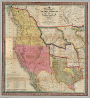
Author
Mitchell, Samuel Augustus
Full Title
A New Map of Texas Oregon and California With The Regions Adjoining. Compiled from the most recent authorities. Philadelphia Published by S. Augustus Mitchell N.E. Corner Of Market & Seventh Streets. 1846. Entered ... 1845 by H.N. Burroughs ... Pennsylvania.
List No
0534.001
Note
With 46 page "Accompaniment to Mitchell's New Map Of Texas, Oregon, and California With The Regions Adjoining;" the full color map is folded into stamped black leather covers 13.5x8 with "Texas, Oregon And California" in gilt. This was one of Mitchell's most popular and important pocket maps. Later editions were published in 1849, 1851, and 1852, as pocket maps and as insets to the large Reference and Distance Map of the United States. It was also issued separately as a wall map. This issue has Texas colored green; some copies have Texas colored brown (has the green changed over time?). The text has a catalogue for Mitchell's publications. Mitchell first issued this map as an inset to his Reference and Distance Map of the United States in the 1846 edition (see our copy).
Full Title
(Eclipses. By Asa Smith. New York: Cady & Burgess, 60 John Street. 1850)
List No
0903.016
Note
Nine (fig. 1-9) black and white illustrations. Title from table of contents.
Author
United States Coast Survey
Full Title
Map of New-York Bay And Harbor And The Environs. Founded upon a Trigonometrical Survey under the direction of F.R. Hassler Superintendent of the Survey Of The Coast Of The United States. Triangulation by James Ferguson and Edmund Blunt Assistants. The Hydrology ... Thomas R. Gedney ... Topography by C. Renard and T.A. Jenkins ... Published in 1844. Presented to The University of Vermont ... A.D. Bache Superintendent, Coast Survey.
List No
2491.000
Note
6 sheets; first engraved chart issued by the U.S. Coast Survey. Without color. Hassler's "Magnum Opus" was not completed until a year after his death. This huge chart is the first major production of the survey, begun by Hassler in response to critic's charges that he was not producing usable charts for navigators, and finished by Bache. A smaller single sheet version was issued in 1845.
Author
[Logerot, Fremin, A.R., Gaultier, J.]
Full Title
(Covers to) Atlas Geographique.
List No
4782A
Note
Colorful cover showing animals, transportation, and people from each continent.
Author
Jackson, William A.
Full Title
Map Of The Mining District of California by Wm. A. Jackson. Published by Lambert & Lane, 69 Wall St. New York. Entered ... 1851 by Lambert & Lane ... New York. (with 16 page appendix) Appendix To Jackson's Map Of The Mining Districts Of California. ... Second Edition, Revised And Enlarged. New-York: Lambert & Lane, 69 Wall-Street. 1851.
List No
2545.001
Note
This is one of the most attractive of the California Gold Rush period maps. Here it is published in pocket map form, with the 16 page "Appendix to Jackson's Map..." which describes the important mining centers. More ornate and detailed than Jackson's map of 1850, this is the only map to label Santa Cruz county "Branciforte." Shows for the first time, some of the mining activity in the south, which Jackson was involved with as an engineer. Map is full color by county, folded into dark green cloth covers 15x10 with "Jackson's Map Of The Mining Districts Of California" stamped in gilt.
Author
Johnson, A.J.
Full Title
A Diagram Exhibiting the difference of time between the places shown & Washington. Ex. the figures on the Dials denote the Air-line distances from Washington. By Johnson & Browning. No. 84.
List No
2905.056
Note
Dials in color and in five rings around the center dial showing Washington at 12:00.
Author
[Mitchell, Samuel Augustus, Young, James H.]
Full Title
Map Of The United States By J.H. Young. Published by S. Augustus Mitchell. Entered ... Pennsylvania, October 10th, 1831 by S. Augustus Mitchell. Engraved by J.H. Young, D. Haines & F. Dankworth. (inset) A Map Of North America Including All The Recent Geographical Discoveries. (with 10 additional inset maps).
List No
2723.001
Note
1st edition, 1st wall map issued by Mitchell. This edition does not have the counties delineated and numbered. Ristow mistakenly says all editions have the townships (he means counties) numbered, but this one, the first, does not, thereby eliminating the index of counties and thus showing more of the western territory. This map predates the Traveler's Guide by 1 year, and thus is Mitchell's first "original" production, as opposed to the Finley material he reissued as the American Atlas and Pocket Maps. The case for the map has a leather label saying "Traveler's Map of the United States." Copyright date is October 10, 1831. There is no other date on the map. Ristow thinks the map was issued in early 1832, but it is not in Phillips until 1834 edition (which probably has the counties indicated by number and the 1831 copyright), so Ristow may not have seen this edition, but rather the 1834. The map is hand painted in bright full color by state (insets by county), dissected in 24 sections with green paper end sheets, mounted on linen and edged in pink silk. The covers 24x20 are half red leather marbled paper covered boards with ties and a leather label embossed with "Traveller's Map Of The United States" in gilt.
Author
[Bayley, W.S., Smyth, H. L., Van Hise, C.]
Full Title
Detailed Geology Sheet XXVIII. (T 47 N, R 27 W, NE Quarter). Julius Bien & Co. Lith. N.Y.
List No
1111.025
Note
Relief shown by 20-foot contours. Colored geologic map shows railroads, roads, trails, settlements, swamps, streams, lakes, rock types, and outcrops. Geologic cross sections included.
Author
[Colton, J. H., Creuzbaur, Robert, De Cordova, Jacob]
Full Title
J. De Cordova's Map Of The State Of Texas Compiled from the records of the General Land Office of the State by Robert Creuzbaur, Revised and Corrected by Charles W. Pressler. Published by J.H. Colton & Co. No. 172 William St. New York 1856. Engraved by J.M. Atwood, New York. Entered ... 1856 by J. De Cordova ... Texas. (with untitled inset of southwestern U.S.).
List No
3366.001
Note
First edition of Pressler's revision of De Cordova's map, and first edition published by Colton. Shows Texas east of the 102nd meridian. First issued by De Cordova in 1849, with editions of 1850, 51, 53, 56, 57, 58, and 61 (Ristow and Rosenberg), and a late unlisted edition in 1867 (see our #4801). De Cordova employed Pressler to revise the map in 1855 and then sold the rights to Colton in the same year. The 1849 edition has only two copies located. Eberstadt called the 1849 issue "possibly the finest (Texas map) of the period." Colton changed the inset map from the oval showing all of Texas to the southwestern portion of Colton's U.S. atlas map. J.M. Atwood was the engraver of all editions. With a list of the Land districts, this map was useful for both land promoters and settlers. Colton published a reduced version of the map in his 1856 Atlas of the World. The full color map is folded into stamped dark maroon leather covers 16x10.5 with "J. De Cordova's Texas J.H. Colton & Co. New York." in gilt.
Author
Humboldt, Alexander von, 1769-1859
Full Title
Pic d' Orizaba vu depuis la Foret de Xalapa. de l'Imprimerie de Langlois. 17. Fr. Gmelin perf. Romae 1805. A. de Humboldt ad nat. del. 1804. Fr. Arnold sc. Berol. 1807.
List No
0328.017
Note
View of Orizaba.
Author
[Spangenberg, Charles, Matz, Otto H.]
Full Title
Map Of The Siege Of Vicksburg, Miss. By the U.S. Forces Under The Command Of Maj. Genl. U.S. Grant, U.S. Vls. ... Surveyed and constructed under the direction of Capt. C.B. Comstock ... by Major Otto H. Matz ... Chs. Spangenberg ... Drawn by Chs. Spangenberg ... Engr. on stone by J. Schedler No. 120 Pearl St. N.Y. Head Qrs. Of The Dept. Of The Tenn. Vicksburg Miss. Aug. 20th 1863. C.B. Comstock ...
List No
3858.000
Note
Signed in facsimile by C.B. Comstock and dated Aug. 20, 1863, Vicksburg, Miss. Beautiful, highly detailed black and white map showing the topography around Vicksburg, with five profiles, six cross sections of batteries and one cross section of a "rebel rifle pit." Illustrated in Stephenson, this is one of the most striking of the Union War maps. Plate 36:2 in "Atlas to Accompany..."
Author
Northern Pacific Railway Company
Full Title
Yellowstone National Park. Northern Pacific Railway. Poole Bros., Chicago. Copyrighted, 1898, by Poole Bros., Chicago.
List No
4118.001
Note
Relief shown by shading and spot heights. Shows completed and proposed railroads. David Rumsey Collection copy: A traveler has marked his route around the park in red ink.
Author
Jefferys, Thomas
Full Title
Thomas Jefferys Engraver Geographer to His Royal Highness the Prince of Wales, at y Corner of St. Martins Lane near Charing Cross Sells great Variety of Prints English and Foreign by the most Celebrated Masters And all Sorts of Maps and Globes. Ant: Walker. Inv: del: et Sculpt. (trade card advertisement).
List No
4239A
Note
A rare advertisement for Jefferys' publications and products. The date is estimated. It is interesting that this does not emphasize the maps as much as the prints, reflecting the fact that he had a large business at this time as a general engraver. Apparently, he published this trade card to "mark his arrival in the Strand" (Harley, Imago Mundi XX), and to announce the opening of his new premises there. Card uncolored.
Author
[Hall, E.S., Lloyd, H.H., Waters & Son]
Full Title
Military Portraits. Glossary Of War Terms, Maps, Arms, Etc. (Map of) Maryland, Virginia, Chesapeake Bay, Etc., Etc. Published by H.H. Lloyd & Co., 25 Howard Street, New York. Agents wanted to sell this and many other Charts for the times. Entered ... 1861, by H.H. Lloyd & Co.
List No
5395.000
Note
A very decorative Civil War chart showing military uniforms and dress, 10 portraits of prominent Union Officers, and a map delineating battles around Washington.
Author
[Blaskowitz, Charles, Faden, William, 1750?-1836]
Full Title
A Topographical Chart of the Bay of Narraganset in the Province of New England, with all the Isles contained therein, among which Rhode Island and Connonicut have been particularly Surveyed, Shewing the true position & bearings of the Banks, Shoals, Rocks &c. as likewise the Soundings: To which have been added the several Works & Batteries raised by the Americans. Taken by Order of the Principal Farmers on Rhode Island, By Charles Blaskowitz. Engraved & Printed for Wm. Faden, Charing Cross, as the Act directs, July 22d 1777. To the Right Honourable Hugh Earl Percy, Baron Percy, Lucy, Poinings, Fitz-Paine, Bryan & Latimer, Lieutenant General of His Majesty's Forces in Great Britain and America. This Plan is ... most humbly Inscribed, by ... Wm. Faden. (in manuscript) Hinck S.
List No
3951.001
Note
The most important map of the area around Providence and Newport issued during the Revolution. With hand painted color. A separately issued copy dissected into 16 sections and mounted on linen. Folds into a marbled slip case 24x17 with a paper label with "Rhode Island" printed in manuscript.
Author
[Brockhaus, F.A., Leeder, Ehrenfried, Leutemann, Heinrich]
Full Title
Afrika.
List No
6819.052
Note
Lavishly illustrated around margins of map with high quality vignettes of animals, structures and people. Relief shown in hachures.
Author
Loring, Josiah
Full Title
Loring's Terrestrial Globe containing all the Late Discoveries and Geographical Improvements, also the Tracks of the most celebrated Circumnavigators. Compiled from Smith's new English Globe, with additions and improvements by Annin & Smith. Boston: Josiah Loring, 136 Washington St. 1833.
List No
2899.000
Note
1st terrestrial globe by Loring. Loring's first globe was the 12" celestial of 1832. Loring's address is 136 Washington Street, Boston. Accompanied by the 12" celestial globe of 1833. Both the terrestrial and celestial were copied (with credit given) from C. Smith's English globes. Annin & Smith of Boston did the engraving. Loring was succeeded in business by Gilman Joslin who continued to produce globes under Loring's name until the 1850's (Warner). These two globes were commended by the Judges at the 1833 fair of the Massachusetts Charitable Mechanic Association (Warner). Four legged table model with horizon ring. Total height from bottom of base to top of the meridian is 17.5 inches.
Author
[Mitchell, John, Raynal, G.T., Zatta, Antonio]
Full Title
(Composite Map of) Le Colonie Unite dell' America Settentrle. di Nuova Projezione Ass. Ee. Li Signori Riformatori dello Studio di Padova. Venezia 1778, Presso Antonio Zatta, con Privilegio dell' Eccellentissimo Senato. (Fogl. I-XI and title page.)
List No
5007.016
Note
Composite of maps Fogl. I-XI and the title page which includes the map of Bermuda.
Author
Cassini, Giovanni Maria
Full Title
Globo terrestre delineato sulle ultime osservazioni con i viaggi e nuove scoperte del Cap. Cook, inglese. In Roma, Presso la Calcograf(i)a Cam(era)le, 1790. Gia. Ma. Cassini, C.R.S. inc. (1792)
List No
5749.001
Note
Relief shown pictorially. First of 4 sheets of gores to make up a globe. Contains title and shows the Americas. The contemporary discoveries in the Pacific Ocean are shown in great detail with the courses of Cook's three voyages delineated. Cf: Library of Congress Geography and Map Division copy (G3201_B71_1790) on 5 sheets. Appeared in the author's Nuovo atlante geografico universale delineate suelle ultime osservazioni, Roma : Presso la Calcografia Camerale, 1792-1801.
Author
[Cook, James, 1728-1779, Webber, John, 1751-1793]
Full Title
A man of the Sandwich Islands, in a mask. J. Webber del. T. Cook sculpt. (London, G. Nicol and T. Cadell, 1785)
List No
3405.076
Note
Engraved illustration.
Author
Ensign, Bridgman & Fanning
Full Title
World At One View. Ensign, Bridgman & Fanning, Publishers, 156 William St., New York. Entered...1854, By Ensign, Bridgman & Fanning...New York.
List No
5087.000
Note
This pictorial map gets larger with each issue: this 1854 edition is almost twice the size of the of the (1852) edition. More illustrations are added, including a large "Universal Dial Plate Or Times Of All Nations." A classic mid century graphic.
Author
Lucas, Fielding Jr.
Full Title
A Chart of the Chesapeake And Delaware Bays Compiled And Published By Fielding Lucas Junr. Baltimore Corrected_1840. Engraved by John and William Warr Philadelphia. Entered ... 1832 by Fielding Lucas Jr. ... Maryland.
List No
5436.000
Note
Full color map mounted on linen with four views of the coast. Tide tables for both bays, soundings and red dots for lighthouses are noted. See our 6858.000 for the 1862 edition.
Author
Tanner, Henry S.
Full Title
(Title Page to) A New American Atlas Containing Maps Of The Several States of the North American Union, Projected and drawn on a Uniform Scale from Documents found in the public Offices of the United States and State Governments, and other Original and Authentic Information, By Henry S. Tanner ... Philadelphia: Published By H.S. Tanner. 1825. (title page only) Writing Drawn and Engraved by Joseph Perkins. Barralet del. Humphrys sc.
List No
2755C
Note
2nd edition, maps and title page dated 1825, except S.A. 1823. Like P3669, except S.A. dated 1823 and N.A. dated 1825. Fine copy with extra large sheets bound in full tree calf edged in gilt - the most beautiful and elegant binding we have seen of an American Atlas, stamped "Davis, Binder - Philada." The spine is titled "American Atlas" on a red leather label in gilt. Memoir dated 1825, with slight changes from the 1823 memoir. The index sheet is numbered 1-22 in two columns, vs in one column in the 1823 edition and in two columns numbered 1-17 in the 1833 editions. The maps of the World and America have Arctic discoveries not shown in earlier editions, as does the N.A. map which also shows the Russian Alaska boundary of 1824. The state maps have various updates from the earlier issues (mostly adding counties) although three (Maine etc., Penn., N. & S. Carolina) have 1825 dates with no obvious changes from the earlier issues. See our table comparing all five editions map by map. According to Wolter (Mountains & Rivers article) the 1825 S.A. map has a more elaborate mountains and rivers diagram than any earlier issues. This issue of the atlas can be truly called an edition - all the maps have 1825 dates and the geography is current; the 1823 parts issue is also an edition. Later editions were compilations - some maps were updated, others were not or were taken from out of date issues. Full color.
Author
Cook, James
Full Title
A Map of the Province of South Carolina with all the Rivers, Creeks, Bays, Inletts, Islands, Inland Navigation, Soundings, Time of High Water on the Sea Coast, Roads, Marshes, Ferrys, Bridges, Swamps, Parishes Churches, Towns, Townships; Country Parish District and Provincial Lines. Humbly inscribed to the Hon.ble Lawlins Lownds Esqr. Speaker & the rest of the Members of the Hon.ble the Commons House of Assembly of the Province by their most Obedt. & faithfull Servt Jams Cook. Thos. Bowen, sculpt. 1773. (with 6 inset maps).
List No
5174.000
Note
The maker of this map, James Cook, surveyor of South Carolina and former marine surveyor, is not to be confused with the Pacific explorer, Captain James Cook. In 1770, James Cook was commissioned by the South Carolina provincial government to make a new survey of the entire province and publish a map, which he completed in 1773. Cummings refers to the map as "the most detailed and accurate printed map of South Carolina, especially for the interior, yet to appear" and further states that "very few copies of this fine map are extant." It provided much of the detail for the later maps by Henry Mouzon and John Stuart. Sellers and Van Ee call it "one of the most important maps in the cartography of the state until the early nineteenth century." It is excessively rare, with only five copies identified in United States institutions, and one in the British Museum. There are two states of this first and only issue, distinguished by the presence in the second state of an additional imprint "Publish'd according to Act of Parliament July 7th. 1773 and Sold by H. Parker in Cornhill" under the neat line. This copy is the first state, with two of the other six copies being first state as well. There are six inset maps: Beaufort, Camden, Georgetown, Port Royal, Charles Town, and Harbour of Charles Town. The main map is very detailed, showing land owners in profusion. Along the coast are many navigation notes, indicative of Cook's maritime background. This appears to have been Cook's only major map production; his other work is limited to three harbor charts published in 1766 (illustrated by Black): A Draught of Port Royal Harbour (similar to the Port Royal inset map on the South Carolina 1773), A Draught of the Harbour of Halifax, and A Draught of West Florida.
Author
Ridgway, Robert
Full Title
Perisoreus canadensis var. capitalis ad. R. Ridgway del. T. Sinclair & Son lith., Phila. (1875)
List No
2220.177
Note
Color lithographed drawing of bird.
Author
Robert de Vaugondy, Gilles, 1688-1766
Full Title
(Title Page to) Atlas Universel, Par M. Robert Geographe ordinaire du Roy, et Par M. Robert De Vaugondy son fils Geographe ord. du Roy, et de S. M. Polonoise, Duc de Lorraine et de Bar, et Associe de L'Academie Royale des Sciences et belles Lettres de Nancy, Avec Privilege Du Roy, 1757. A Paris, Chez Les Auteurs ,Quay de l'Horloge du Palais, Boudet Libraire Imprimeur du Roi, rue St. Jacques. Grave par Ch. Baquoy. J. Oger Scripsit.
List No
3353B
Note
1st edition, with five postal maps added, as issued. With the list of subscribers and the extra postal maps of England, France, Germany, Italy and Spain. The French postal map is dated 1758. All five were added after the printed list of maps was printed, but are mentioned by Vaugondy in the preface, so they may have been an afterthought. An owner has added their titles to the printed list of maps, in ms. Engraved title page, Advertisement, and Geographical essay giving the sources of the maps. This atlas was reissued until 1799 (Phillips), with later issues having a map of the United States. In original half leather patterned paper covered boards with spine reading "Nouvel Atlas De Mrs. Robert." One of the first atlases based on scientific surveys, in the tradition of D'Anville and De L'Isle. Outline color.
Author
Rand McNally and Company
Full Title
Letter from Rand McNally & Co. to The Montana Mining Co. dated Feb 21, 1899, offering the 1899 edition of the Business Atlas & Shippers' Guide.
List No
3698A
Note
Regarding the atlas, the letter states "we are confident you will find it a work that will give good satisfaction whenever consulted." Written across the top of the letter in hand by the recipient "ordered on Feb 25/99."
Author
Cassini, Giovanni Maria
Full Title
Globo Celeste calcolato peril corrente anno sulle osservazioni de Sigg. Flamsteed e de la Caille. Roma : Calc(ografi)a Cam(era)le, 1792. Inciso dal P. Gio. Ma. Cassini, C.R.S.
List No
5750.001
Note
Relief shown pictorially. First of 4 sheets of gores to make up a globe. Features a particularly decorative projection of the heavens and is attractively colored, with the constellations shown in their classical forms. Appeared in the author's Nuovo atlante geografico universale delineate suelle ultime osservazioni, Roma : Presso la Calcografia Camerale, 1792-1801.
Full Title
Proportion of foreign born of each leading nationality, by states and territories: 1900. (Prepared under the supervision of Henry Gannett, Geographer of the Twelfth Census. United States Census Office, 1903). Julius Bien & Co., N.Y.
List No
2152.063
Note
Color lithographed chart.
Author
[Craven, A., Hoffman, Hoffmann, C.F., Leicht, F., Geological Survey of California]
Full Title
State Geological Survey Of California, J.D. Whitney, State Geologist. Map Of California And Nevada. Drawn By F.v. Leicht And A. Craven ... J. Bien, Lith. N.Y. 2nd edition Revised by Hoffmann and Craven and issued by authority of the Regents of the University of California given May 12th 1874.
List No
0115.000
Note
1st edition was 1873. Under the title is the following Note: "In the compilation of this map the following materials were used. For California: The work of the State Geological Survey and that of the U.S. Coast and Land Surveys. For Nevada: The work of the Fortieth Parallel Survey, under Clarence King, the U.S. Engineer Explorations under Williamson and Wheeler; the Central Pacific Railroad Survey under Butler Ives; and the work of the California Survey, by Wackenreuder, Craven, Wilson and Loehr from 1863 to 1872." Full printed color. Map is dissected into 54 sections and mounted on linen. Folds into a tan cloth folding case 19x13 with "California & Nevada California Geological Survey 1874" stamped in gold on the spine.
Author
Ensigns & Thayer
Full Title
Map of the Gold Regions of California, Showing the Routes via Chagres and Panama, Cape Horn, &c.
List No
4683.000
Note
This is the thin paper copy with smaller ornamental border and no publisher credit. Wheat believes it was folded into some copies of Farnham's "Life, Adventures, and Travels in California;" our copies of that book have the Haven map pasted in one (see our #3963) and this map pasted in the other (see our #5001). This copy shows signs of being folded. It was probably sold with the book and separately. The text is the same as the broadside issue but the title is in different type. Scarce.
Author
Colton, J. H.
Full Title
(Box Cover to) J.H. Colton's Series of Dissected Maps. North America. South America. Europe. United States. Asia. Africa. In Two Sizes. (On the side of the box: United States). (Title of Map Puzzle: United States of America. Entered ... In the Year 1860 ...).
List No
4329A
Note
Box cover includes list of the available dissected maps in the Colton series. The label for this specific map is on the side and is entitled "United States."
Author
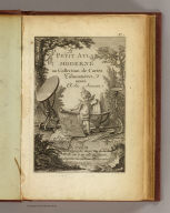
[Delamarche, Charles Francois, Lattre, Jean]
Full Title
(Title Page to) Petit atlas moderne ou collection de cartes elementaires dedie a la jeunesse. A Paris, chez Delamarche, Geogr., Rue du Jardinet No. 13, vis a vis celle de l'Eperon. (ca. 1800)
List No
0421B
Note
Engraved illustrated title page showing cherub with globe, maps, surveying instruments, etc. Called "Frontispice" in table of contents.
Author
[Finley, Anthony, Vance, David H.]
Full Title
New Map of the United States. Anthony Finley ... Proposes to publish, by subscription, A New and Elegant Map of the United States. Philadelphia, March 27th, 1824.
List No
3961B
Note
Proposal for subscribers. The map was published in 1825 (see our copy, #3961001). This proposal also was published in the back of the 1824 General Atlas, first issue (see our copy, #2680). Pub. Note gives details about the map itself.
Author
Spurr, Josiah Edward
Full Title
Tourtelotte Park Mining District Sheet. Sheet XXIII Sections. U. S. Geological Survey, Charles D. Walcott, Director. Monograph XXXI. Julius Bien & Co. Lith. N.Y. (1898)
List No
0942.020
Note
Geologic cross-sections shown in color in 9 classes, and faults.
Author
Levasseur, Victor.
Full Title
Dept. De Corsica. Atlas National Illustre. Region du Sud. No. 19. Paris. Impie. Dupuich. 14. Cour St. Jean de Latran. A Paris, chez l'Editeur, Rue de la Parcheminerie, 15. (1856)
List No
0427.019
Note
Margin illustrations lavish and of excellent quality showing local heros, products, landscapes, dress, and coat of arms. Forests shown by stippling. District boundaries, roads, towns and cities shown. Color along boundaries. Rivers shown. Text shows local statistics, map legend, and discusses land, curiosities, personages, products, and commerce. Steel engraving.
Author
[United States. Census Office, Walker, Francis Amasa, 1840-1897]
Full Title
Map showing the distribution of wealth. Compiled from the tables of "true valuation," ninth census of the United States, 1870. By Francis A. Walker. (Julius Bien, Lith., 1874)
List No
3566.030
Note
Colored lithographed map.
Full Title
Mouth of the Lower Grand Canon of the Colorado River. 1871. U.S. Geographical Surveys West of the 100th Meridian. (1889)
List No
2220.020
Note
Color lithographed view. "Plate No. XX is an illuminated sketch made from a photograph taken in the Grand Canon near its mouth ... The sun breaking through upon the vari-colored sedimentary beds enlivens a contrast of colors that no artist can accurately copy."-- v. 1, p. 163.
Author
Andreas, A. T. (Alfred Theodore), 1839-1900
Full Title
(Portraits of) Citizens of Cedar Rapids, Linn County, State of Iowa: George Greene, S.C. Bever, W.W. Walker, T.M. Sinclair, H.G. Higley, S.L. Dows, Gabriel Carpenter, E.S. Hill, C.C. Cook, D.W.C. Rowley, E.L. Mansfield, J.R. Kinney, Thos. Gainer, J.F. Ely, A.B. Hull, W.D. Watrous, Wm. Stewart, J.G. Graves, J.S. Cook, J.M. May. Chas. Shober & Co. props. Chicago Litho. Co. (Published by the Andreas Atlas Co., Lakeside Building, Chicago, Ills. Engraved & printed by Chas. Shober & Co., Props. of Chicago Lithographing Co.)
List No
0018.118
Note
Twenty lithographed portraits with 4 views.
Author
Arrowsmith, Aaron
Full Title
Outlines Of The Physical And Political Divisions Of South America: Delineated By A. Arrowsmith Partly From Scarce And Original Documents, Published Before The Year 1806 But Principally From Manuscript Maps & Surveys Made Between The Years 1771 And 1806, Corrected From Accurate Astronomical Observations To 1810. London, Published 4th January 1811 by A. Arrowsmith No. 10 Soho Square, Hydrographer to H.R.H. the Prince of Wales. Additions to 1814. Engraved by Edwd. Jones ... (inset map of the southern tip of South America).
List No
2099.000
Note
Removed from Arrowsmith's Atlas to accompany Thompson's Alcedo. Comparing to the 1811 77(a) first issue, there are changes in the coast line between Buenos Aires and Rio, and on the northeast coast, Maranham. This map is enormous, on six large sheets, measuring over eight feet tall when joined together. Outline color by country. Without top and bottom rollers.
Author
La Perouse, Jean-Francois de Galaup, comte de, 1741-1788
Full Title
(Two views). Japanese Boat(s). Published as the Act directs Novr. 1st 1798, by G.G. & J. Robinson, Pater Noster Row, London. Blondela del. Heath sculpt. No. 59.
List No
0414.059
Note
Engraved.
Author
[USGS (U.S. Geological Survey), Renshawe, John H.]
Full Title
Panoramic View of the Mount Rainier National Park, Washington.
List No
6925.000
Note
Date estimated. Shaded relief without contours. Full color artistic rendering of the park. Part of a series for the national parks.
Author
[Everts & Co., Haskell & Wood, L.H. Everts & Co.]
Full Title
(Title Page to) The official state atlas of Kansas compiled from government surveys, county records and personal investigations. Philadelphia. L.H. Everts & Co. 1887. (on verso:) Copyright, 1887, L.H. Everts & Co. (with view:) State Capitol, Topeka, Kan. Haskell & Wood, Arch's. F.F. Goist Sc.
List No
2818B
Note
Huge atlas, many maps and views, scarce. With 340 numbered pages (plus many unnumbered pages) of maps and views this must be the largest State Atlas published (Andreas' Iowa has 250 pages of maps and views). The views show the remarkable development of the state over two decades after the Civil War. Many large folding maps of cities are included. Bound in new burgandy cloth covered boards with "The Official Atlas Of Kansas 1887" stamped in gilt. Maps hand painted in full color.
Author
Arrowsmith, Aaron
Full Title
Map of Scotland Constructed from Original Materials Obtained under The Authority of The Parliamentary Commissioners For making Roads and building Bridges In the Highlands of Scotland With whose permission it is now published By Their most obliged and obedient Servant A.Arrowsmith Hydrographer to H.R.H. the Prince of Wales. London. Published June 25th. 1807 by A. Arrowsmith 10 Soho Square
List No
6702.000
Note
Dissected and mounted on linen. Accompanied by a Memoir on the Map of Scotland (not present here). A fine map of Scotland with great amounts of detail on the road system and the topography.
Author
[Bligh, William, 1754-1817, Cook, James, 1728-1779, Webber, John, 1751-1793]
Full Title
Part of Japan or Nipon. (with) View of the coast of Japan when we first saw it. (Engraved by) W. H(arrison after a missing survey possibly by Bligh and a view by Webber. London, G. Nicol and T. Cadell, 1785)
List No
3405.022
Note
Engraved nautical chart with coastal view. Relief shown pictorially; depths by soundings. Shows coastal features and ship's track. "79."
Author
Duflot de Mofras, Eugene
Full Title
Tete De Chef Indien De La Cote Nord Ouest De L'Amerique. Armes et ustensiles des Indiens de la Nouvelle Californie. No. 25 de l'Atlas. Publie par Arthus Bertrand. Imp. par Lemercier. Lith. par Muller. Voyage de Mr. Duflot de Mofras.
List No
4119G
Note
Uncolored drawing of an Indian from California along with his utensils, tools and attire.
Author
[Moll, Herman, d. 1732, Verden, Carl van]
Full Title
The Caspian Sea. Drawn by the Czar's Special Command by Carl van Verden in the year 1719, 1720 and 1721. This exact copy is done by H. Moll Geographer. (with view) The Castle, the City of Terky. (with) A view of the City of Derbent. (with) A view of the City of Astracan. (Printed and sold by T. Bowles next ye Chapter House in St. Pauls Church yard, & I. Bowles at ye Black Horse in Cornhill, 1736?)
List No
5580.031
Note
Hand col. engraved map with 3 views. Relief shown pictorially. Includes geographical notes.
Author
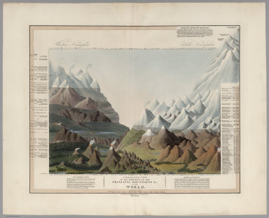
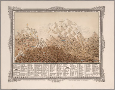
Smith, C.
Full Title
Comparative View of the Heights of the Principal Mountains &c. in the World. London, Published by C. Smith Mapseller, No.172 Strand, Augt. 1st. 1816. Gardner, Sculpt. (Third Edition)
List No
6933.000
Note
Third edition. A colorful rendering of comparative mountain heights worldwide, although separated into the Western and Eastern Hemispheres. Other aspects of the illustration (with the exception of showing volcanoes) appear to be fanciful. Substantially more taller mountains than an earlier edition (see our although dates uncertain because the date of 1816 is the same. The peaks are listed, each with a unique number which can be matched up with the numbers at the top and bottom of the illustration. By making a line between the numbers, the corresponding peak is intersected. Latitudes, sources, and altitudes also listed.
Author
Sotzmann, Daniel Friedrich
Full Title
Rhode Island entworfen von D.F. Sotzmann. No. V. Hamburg bey Carl Ernst Bohn 1797. ... gestochen von H. Kliewer. zu Ebelings Erdbeschreibung von Amerika.
List No
2746.004
Note
This was the largest scale map of the series. Full color by county.
Author
Colton, J. H.
Full Title
Nebraska And Kansas. Published By J.H. Colton & Co. No. 172 William St. New York. Entered ... 1854 by J.H. Colton ... New York. (inset) Map Of The Territory acquired from Mexico by the Gadsden Treaty, 1854. (untitled inset of U.S., Mexico, Central America). Printed by D. Mc Lellan, 26 Spruce St. N.Y.
List No
3873.001
Note
First edition, first state. First map to show the new Kansas and Nebraska; also shows the important Gadsden Purchase of the same year. This state precedes all other copies we have seen - it is an early pull from the late 1854, early 1855 Colton Map of the United States of America... wall map plate (see our #2834, indicating it appeared in middle or late 1854 - see our 1855 wall map copy #2278 for the corrected topography), with the title different from the second 1854 state, in that the letters of Nebraska and Kansas have stars in them and are open as opposed to the black letters of the second state. Also, this first state has numerous areas that are "cleaned up" in the second state: the trail that crosses the two forks of the Colorado in southern Utah near the map edge has the word "Route" on it - this is removed in the second state; the vine border is reversed from the first to the second state; Louisiana is written straight across in the first - it curves down in the second; Bucksport and San Augustine are shown in Texas along the map southern edge in the second state and not in the first; Sacket's Well and Laguna in California in the inset map are given dots for their location in the second state but not in the first. There are other changes. Streeter shows a second edition in 1855, Heaston a third edition in 1856, but both copyrighted 1855. These have various route changes and place names added when compared to the 1854. A fourth edition appeared in 1857 (see Karrow 12-0361.2 and Graff 836) with the inset of the U.S. changed to Eastern Nebraska and Kansas. Map is full color by state, folded into red cloth covers 15x9 with "Nebraska And Kansas" stamped in gilt, advertisement for Colton on inside front cover.
Author
Johnstone, E. McD.
Full Title
The Unique Map Of California. Copyrighted. E. McD. Johnstone. Dickman-Jones Co. Lith. S.F. (with 3 inset maps, 1 profile).
List No
4349.000
Note
The date is estimated from the county formation (San Benito and Del Norte). This is a remarkable map with twenty vignettes of California scenes and three inset maps showing soil, temperature, and areas. Another inset shows the heights of the Sierra Nevada mountains. All these elements combine to make a beautiful map. Little is know about the maker, Johnstone, except that he drew the Climatic Map of California as well (see our #941). Printed in full color.
Author
Pick, Eug.
Full Title
Tableau De L'Histoire Universelle depuis la Creation jusqu'a ce jour. Paris, Eug. Pick, Libraire-Editeur, Rue du Pont de Lodi, 5. Frault aine, imprimeur, Paris, rue des Noyers, 67. 1858
List No
3246.001
Note
Compare to Colton's Stream of Time, 1842. Has vignettes of people, buildings, historical scenes and important places in the history of the world. Full color. Dissected into 9 sections and edged in white cloth.
Author
[Brockhaus, F.A., Leeder, Ehrenfried, Leutemann, Heinrich]
Full Title
Vorderindien.
List No
6819.051
Note
Lavishly illustrated around margins of map with high quality vignettes of animals, structures and people. Relief shown in hachures.
Author
[USGS (U.S. Geological Survey), Renshawe, John H.]
Full Title
Panoramic View of the Crater Lake National Park.
List No
6087.000
Note
Date estimated. Shaded relief without contours. Full color artistic rendering of the park. Part of a series for the national parks.
Author
Rand McNally and Company
Full Title
Rand - McNally Official Railway Map Of The Pacific Coast States Including Territory East To Denver ... Copyright, 1902, by Rand, McNally & Co., Chicago. Copyright, 1893 ... 1898 ...
List No
4484.000
Note
A big, wonderful, large scale map of the American west from central Colorado to the coast. Shows all railroads in operation, topographical features and public surveys. It is copyrighted in 1901 with the present title (indicating that it may be the first edition in this form) and in 1893 and 1898 as "Rand, McNally & Co.'s Standard Map of the United States" (suggesting that it may have been derived from a larger map of the entire U.S.). A pocket map version was also made of different parts of this map - see our 1888 Standard Map of California and Nevada, with the scale slightly enlarged. Outline color by state. Dissected into 42 sections. Folds into a new black cloth folding case 29x23 with "Pacific Coast States Rand McNally 1901" stamped in gilt along the spine.
Author
Jouvet et Cie.
Full Title
Carte Geologique de la Region Francaise. Atlas St. Cyr. G. Hue. Furne, Jouvet et Cie. Editeurs. Imp. Lemercier et Cie. Paris. (1882)
List No
5785.008
Note
Full color of geologic formations. Relief shown in hachures. Inset of Corsica.
Author
Harnett, Richard V.
Full Title
Richard V. Harnett, auctioneer, office, 111 Broadway, N.Y. Executor's sale! Nos. 32 & 34 Attorney Street near Grand Street ... Martin B. Brown, book, job and diagram printer, 49 and 51 Park Place, N.Y.
List No
5737.000
Note
Auction to be held on Feb. 27, 1883. By order of George G. Hallock, Esq., executor of the estate of Mathias Ludlow, deceased. Includes map showing the 2 lots and shows block bounded by Attorney, Broome, Ridge and Grand streets. Measurement is sheet size. David Rumsey Collection copy: has pencil notation on plan indicating price of $11,300 for one house and $11,450 for the other, and name Tobias Krakauer, 32 Hester St. Laid in: Atlas of the entire city of New York ... G.W. Bromley & Co., 1879 (our no. 2597)
Author
Thomson, John
Full Title
(Composite of) Northern part of Roxburgh Shire, Southern part of Roxburgh Shire. (with) View of Melrose Abbey, Church. (with) View of Jedburgh Abbey. Engd. by N.R. Hewitt, London. Published by John Thomson & Co., Edinburgh, 1822. (1832)
List No
5748.015
Note
Digital composite of 2 hand colored engraved maps. Relief shown by hachures. Shows settlements, roads, etc.
Author
Lloyd, H.H.
Full Title
The National Political Chart. Lloyd's New Political Chart, 1861. With a Map of the United States, showing the Free States, Border Slave States, Cotton States, and Territories, in Different Colors. Published at H.H. Lloyd & Co.'s Agents' General Depot for Books, Maps, and Stationery Packages, 25 Howard Street, New York. Entered ... 1861, by H.H. Lloyd & Co. ... New York.
List No
5530.000
Note
Map of the U.S. is in full color with a large red border delineating the Slave States. Numerous portraits, biographies, and statistics are included.
Author
Melish, John
Full Title
Map of Illinois Constructed from the Surveys in the General Land Office and other Documents By John Melish. Saml. Harrison, sct. Entered according to Act of Congress the 16th day of April 1818. Philadelphia. Published by John Melish. Improved to 1820.
List No
5537.000
Note
Melish, in his first edition of "A Geographical Description of the United States," (1816) wrote of his plans to publish a series of sheet maps on a uniform scale that would form an atlas of the United States. He reiterated this plan in the 2nd and 3rd editions of the "Geographical Description" and expanded upon it in "A Geographical Description of the World" in 1818. According to Ristow, this plan to publish the maps at the same scale was "a new and revolutionary idea that facilitated size comparisons." Indiana was the first to be published in 1817. Tennessee was published in 1817. The Illinois map followed in 1818, with an "improved" edition in 1819. No mention is made in any sources of this map, "improved to 1820." Alabama was completed in 1818, Mississippi in 1819, and Louisiana in 1820. Only these six maps were completed before Melish died in 1822. A copy of the 1818 Illinois map is held at the Library of Congress. The 1819 map is held at the Newberry Library and the National Archives. No copy of the 1820 edition has been mentioned in the references. The map is in outline color by county with township and survey lines shown.
Author
[Bourne, A., Hough, B., Melish, J.]
Full Title
A Map of the State of Ohio from Actual Suy by B. Hough & A. Bourne. Eng'd. by H.S. Tanner Philada. Entered ... 27th day of June, 1814, by B. Hough and A. Bourne, of the State of Ohio. Chillicothe: Published 1st May 1815, by B. Hough & A. Bourne, and J. Melish, Philadelphia.
List No
5571.000
Note
County boundaries tinted in color. Townships clearly shown. An extensive key is included detailing land ownership history and some land use. Northwest portion of state not surveyed but shows swamplands and plains. Meridian Washington.
Author
Eddy, William M.
Full Title
Approved and declared to be the official map of the State of California by an act of the Legislature passed March 25th 1853. Compiled by W.M. Eddy State Surveyor General. Published for R.A. Eddy, Marysville, California by J.H. Colton, No. 86 Cedar St. New York 1854. Authorities --- (with inset:) San Francisco and Adjoining Bays. Engraved on stone by Schedler & Liebler, 129 William St. New York. Printed by D. McLellan, 26 Spruce St. N.Y. Entered according to act of Congress in the year 1853 by Wm. M. Eddy in the Clerk's Office of the District Court of the United States for the Northern District of California.
List No
5582.001
Note
Lithograph, 49 3/4"x 38 1/2" plus floral border. Scale18 miles to an inch. Inset : 19 3/8"x 15 1/2", scale about 2 1/4 miles to an inch. Full color. Once folded, now flattened and backed with rice paper. Folder, 6 1/4"x 4 1/4" (15 x 12 cm.), rebacked, leather covered, blind stamped, title in gilt on front cover; verso front cover leaf of text advertising Colton's maps. In ink on leaf : Genl [name not decipherable] from Wm M Ed[dy ]. This matches signature on Eddy's Surveryor General's Report for 1852. According to Wheat, Eddy died in March, 1854. Wheat states that map was not yet ready in March 1854 but does not give reason. However, Eddy as Surveyor General states in his report dated Dec. 15, 1853 that he has received a few copies of the map and more were soon expected. My copy is signed by Eddy on verso of cover. Acquired from the Warren Heckrotte Collection, which is the source of description and notes.
Author
[Bidwell, John, 1819-1900, Larkin, Thomas Oliver, 1802-1858]
Full Title
Map of the Valley of the Sacramento including the Gold Region. This map is a correct tracing of the map of Bidwell, Land Surveyor, by Thos. O. Larkin Esq: late Consul of the U.S. for California; and by him stated to be the best reference in California. Entered according to act of Congress in the year 1848 by J.H. Bufford & Co. in the Clerks office for the District Court of Massachusetts. Table of Distances (distances by sea to California and points in between)
List No
5583.000
Note
Escala de 15 Leguas Spanish (linear scale). Lithograph, 21 3/8"x 17 1/4", full color. Scale about ---. Folded in cloth case, 5"x 3 1/4", blind stamped, "Gold Region" in gilt on front cover; on verso of front cover, printed paper label, in gilt, reading, "A Correct Survey of the Gold Region California." The map shows Ranchos in the Central Valley and along the American river has "Gold Region" on both sides. Signature in ink on verso front cover, "Stickney & Thaxter". Contained in red leather drop case, gilt trim, title in gilt on spine. Original in Warren Heckrotte Collection, which is the source of description and notes.
Author
Schweickhardt, Franz Xaver
Full Title
(Composite of) Sections I - LXIII Archduchy Austria below the Enns
List No
6937.065
Note
This image is a composite of Sections I to LXIII of the birdseye drawings of the Archduchy Austria below the Enns. (Perspectiv-Karte des Erzherzogthums Oesterreich unter der Ens.) These birdseye views when joined together (see our Composite) make probably the largest such view of any country that we have seen. Together they cover about 3,000 square miles at a large scale of two inches to one mile. They give a unified view of the landscape that is at a consistent scale (unlike other birdseyes that use diminishing perspective), and the level of detail of cultural information is extraordinary. <a href=http://www.davidrumsey.com/view/google-earth-browser#austria-1837 target=_blank>View in Google Earth</a>
Author
Honey Lake Valley Land and Water Company
Full Title
Bird's eye view of Honey Lake Valley. Lassen County California. Honey Lake Valley Land & Water Co. Room 6 Flood Building. San Francisco. (1891?)
List No
5641.000
Note
Uncolored lithographed cadastral map showing sections, drainage, canals, etc. Located on the California/Nevada border. David Rumsey Collection copy in capsule with: Plate No.4 showing reservoir, canals and ditches ... (1891?)
Author
Sanborn Map Company
Full Title
Insurance maps of Frankfort, Franklin Co., Kentucky (sheet 1, index). Sanborn Map Company, 11 Broadway, New York. Sep't. 1907. Copyright 1907, by the Sanborn Map Co. (title on cover and verso of each sheet:) Sanborn map of Frankfort, Ky. For the exclusive use of E.H. Elliott & Co., Agents. This map is not transferable and must not be copied, -- as it is -- copyright by and property of Sanborn Map Company ...
List No
5381.001
Note
Hand col. lithographed map. Graphic index map and street and "specials" index. Includes legend and general information relating to Frankfort fire hazards and protection.
Author
Tanner, Henry S.
Full Title
(Title Page to) A New American Atlas Containing Maps Of The Several States of the North American Union, Projected and drawn on a Uniform Scale from Documents found in the public Offices of the United States and State Governments, and other Original and Authentic Information, By Henry S. Tanner ... Philadelphia: Published By H.S. Tanner. 1823. (title page only) Writing Drawn and Engraved by Joseph Perkins. Barralet del. Humphrys sc.
List No
5388C
Note
The first edition with the earliest states of all the maps. Many believe this to be the finest atlas published in the United States in the 19th century. The text essay (included here) is a wonderful compilation of information on the contemporary maps that Tanner used as sources. Tanner updated the maps frequently over the next two decades, and issued several editions or compilations of the atlas with the title pages dated 1823 or 1825, but with some of the maps dated as late as 1833. The collation of our six issues shows that no two copies are alike and that the maps were being constantly updated; however the choice of maps for each edition reveals a somewhat haphazard approach with some of the earliest states of a particular map appearing the one of the later atlas editions. A completely revised edition was issued in 1839, with the title page and most of the maps dated 1839 (see P1382). Hand painted in outline color with a full color wash. Atlas is bound in half leather marbled paper covered boards with "Tanner's American Atlas" stamped in gilt on a front leather label.
Author
Coelho, Joao
Full Title
Mappa geral dos Estados Unidos do Brazil segundo os mais recentes trabalhos do Engenheiro Joao Coelho e edictado pela Livraria Allema de Ernst Nolte, Buenos Aires, 1891. Lit. e imp. Jose Ruland, Cuyo 361, Bs. As. (with) Plano parcial do Rio Grande do Sul e Santa Catharina. (with) Rio de Janeiro e parte de Minas Geraes e Sao Paulo.
List No
5467.001
Note
Map dissected into 35 sections and mounted on linen. In printed color by state. Dissected into 35 pieces and mounted on linen, it folds to 22x14 and is affixed in a brown leather case with "Mapa Geral Dos Estados Unidos Do Brazil" in gold on the cover.
Author
Finley, Anthony
Full Title
Table of the Comparative Heights of the Principal Mountains &c. in the World ... Published by A. Finley Philada. Young & Delleker Sc.
List No
0285.062
Note
Full color.
Author
Southern Pacific Company
Full Title
(Covers to:) California, Texas, Mexico And Arizona Southern Pacific Co. "Sunset route" from New Orleans to the Pacific Coast ... January, 1892. American Bank Note Co., N.Y.
List No
3139A
Note
Self wrapper cover in color, illustrated.
Author
Ohio and Mississippi Railway
Full Title
(Covers to) Ohio and Mississippi Railway. St. Louis, Louisville, Cincinnati. Direct route between the east and west ... Jan. 1st., 1883. American Bank Note Company, 142 Broadway, New York.
List No
4596A
Author
Johnson, A.J.
Full Title
(Half Title Page to) Johnson's New Illustrated (Steel Plate) Family Atlas, With Descriptions, Geographical, Statistical, And Historical. Compiled, Drawn, and Engraved Under The Supervision Of J.H. Colton And A.J. Johnson. New York: Johnson And Browning, Formerly (Successors To J.H. Colton And Company,) No. 133 Nassau Street. 1860. Entered ... One Thousand Eight Hundred and Sixty, by Johnson & Browning ... Virginia.
List No
2905B
Note
Title on page reads "American Atlas" and is accompanied by an illustration of Indian on a bluff overlooking a river, town and homestead.
Author
[Smith, J. Calvin, Smith, Robert P.]
Full Title
The New Naval And Military Map Of The United States. By J. Calvin Smith, Author Of Harper's Gazetteer, Colton's County Map Of The U.S. Travellers' Guide &c. 1862. J. Baker & Co. Publishers. J.M. Atwood, Map Engraver 517 Minor St. Philadelphia, Pa. Entered ... 1862 by Robert P. Smith ... Pennsylvania. (with 5 inset maps and 3 profiles).
List No
2262.000
Note
1st ed. Stevenson identifies 3 issues. Very beautiful and elaborate map showing the hand of Robert Pearsal Smith (has similarities graphically to his N.Y. State Map of 1860). The map is drawn by J.M. Atwood, but is credited to J.C. Smith, "Author of Harper's Gazetteer, Colton's County Map of the U.S., Traveler's Guide, &c." R.P. Smith is obviously competing with J.H. Colton by using J.C. Smith's name. Also, the population statistics for the 1860 census are listed, "in advance of official publication" (see Colton letter dated 1861 on this subject). Many inset views relating to the civil war, portraits of Union Generals, and thematic map insets. The U.S. map bears a striking resemblance to Colton's U.S. map of the same period (We suspect intentional on Smith's part) but it is different. H.H. Lloyd did a similar map in 1866 (High Ridge #18-165), probably by obtaining Smith's map copyright for this map and the New York State Map in 1865 when Smith left the map publishing business (Ristow p 377). With black top and bottom rollers. Full color by county. Inset showing crops and animals of the U.S. Table of distances. Table of time differences. Profiles route of Lieut. A.W. Whipple's route for Pacific Railroad.
Author
Lewis, Samuel
Full Title
A New and correct Map of The United States Of North America; Exhibiting The Counties, Towns, Roads &c. in each State. Carefully compiled from Surveys and the most Authentic Documents, By Samuel Lewis. W. & S. Harrison sculpt. Philadelphia, Published by Emmor Kimber 1816. Copy Right secured according to Law.
List No
5047.000
Note
This is the first complete edition of this map, the largest wall map of the United States produced by Americans at that time (although Karrow 1-1418 lists an almost complete 1815 edition). Differences from the 1818 edition include Illinois and Indiana shown as Territories, a large Mississippi with no Alabama, and no Arkansas Territory. Also, there are far fewer roads shown, and fewer settlements laid down, especially in Canada. See our #432 for a proposal for publishing this map. With black top and bottom rollers and dark green linen edging. Outline color by state or territory.
Author
Tardieu, P.F.
Full Title
United States of Nth. America. Carte des Etats-Unis de L'Amerique Septentrionale Copiee et Gravee sur celle d'Arrowsmith Corigee...
List No
0987.000
Note
First edition. This map is entirely a copy of Arrowsmith's Map of the United States (see our 1796 issue) except for certain parts (mentioned by Tardieu in his "Note" above the title) that Tardieu has altered and improved, based on other sources. A Plan of Washington, D.C. is also added. Later editions depart more radically from Arrowsmith and this actually becomes a better map in many respects (certainly more up to date regarding new States and Territories) than the Arrowsmith editions, although Arrowsmith remains better in the areas west of the Mississippi. G. Gibbs name on label- a famous scientist, see DAB. Map folds into a new brown cloth folding case 32x26 with "United States P.F. Tardieu 1802" stamped in gilt on the spine.
Author
[Gibbes, C.D., Holt, Warren]
Full Title
Map of the States of California And Nevada. Carefully Compiled from the Latest Authentic Sources. California By Julius H. Von Schmidt, Arthur W. Keddie, And C.D. Gibbes, C.E.'s. Nevada By Chas. Drayton Gibbes C.E. Comprising Information obtained from the U.S. Coast And Land Surveys; State Geological Surveys, By Prof. J.D. Whitney; Railroad Surveys And The Results Of Explorations Made By Brevet Lieut. Col. R.S. Williamson, U.S.A., Henry DeGroot, C.D. Gibbes, And Others. Published by Warren Holt. No. 717 Montgomery St. San Francisco, Cal. 1881. Entered ... 1876 by Warren Holt ... Washington, D.C. S.B. Linton, Engr. & Lithogr. 148-1/2 S. 4th Street, Philadelphia ...
List No
4231.001
Note
This edition is not in Vogdes (he lists editions of 1869, 1876, and 1888). The copyright date is 1876, so it is probably similar to that edition. There are many changes, as one would hope (or expect) between this and the 1869 edition, both in graphic composition and topography. The map has been completely reengraved by S.B.Linton (the original engraver) and shows much of the General Land Office surveys. It is so full of detail as to be difficult to read in many areas. Two views are added: the Capital-Nevada, and University-California. The 1888 edition is reengraved completely yet again (WH's copy). This copy belonged to Lewis M. Clement, Chief Engineer of the Atlantic & Pacific Railroad. The inside of the case flap closure reads "Lewis M. Clement, Chief Engineer of the Atlantic & Pacific Railroad - Office: Safe Deposit Building Room 8 - San Francisco, Cal." in calligraphic manuscript. The map is slightly trimmed at the bottom (affecting only the decorative border) in order to fit into his custom brown cloth case 28x17. Map has outline color, is in two sheets (Northern and Southern halves), each undissected and mounted on linen.
Author
Williams, G. Washington.
Full Title
Williams' Copper - Plate Map Of The United States, Canada, Mexico, Central America, West Indies, &c. Published by John M. Atwood, 402 Locust Street, Philadelphia. Printed by F. Bourquin, 31 So. 6th Street, Phila. Copyright 1876 by G. Washington Williams.
List No
1213.000
Note
Related to Williams' New Nat. Map for Mitchell. Compare to 1857 and 1860 Mitchell New National Map exhibiting the United States... We assume that this Williams is the son of Wellington Williams and that he took over his father's map and reissued it. It is interesting to see that John M. Atwood published this map - it appears that he not only published maps, but also drew them for others, i.e. Colton and Ensign & Thayer. Inset maps include: Island Of Newfoundland; Massachusetts, Rhode Island & Connecticut; The Atlantic Ocean Showing The Communications By Cable And Steam Between Europe And The United States; Is. Of Porto Rico; Virgin Is. And S. Cruz; Islands Of Japan ...; Map Of The Great Pacific Ocean With It's Shores And Islands; Alaska; and The Sandwich Islands Or Hawaiian Group. Full color by state. Map is dissected into 36 sections and folds into a new green cloth folding case 29x29 with "United States, Canada, Mexico &c. G.W. Williams 1876" stamped in gilt on the spine. Relief shown by hachures.
Author
Dumont, Andre
Full Title
Carte Geologique De L'Europe Par Andre Dumont. E. Noblet, Editeur, Paris Et Liege. Lithographie en coulears a l'Impremere Imperiale.
List No
1558.001
Note
Bookplate of Jules Marcou. Printed in full color. Map is dissected into 24 sections, edged in green cloth and mounted on linen. Folds into a new blue cloth folding case 33x26 with "Carte Geologique De L'Europe Andre Dumont 1875" stamped in gold on the spine.
Author
[Brue, Adrien Hubert, 1786-1832, Levasseur, E.]
Full Title
Mappemonde projectee sur l'Horizon de Paris et de Antipode. Mappemonde sur la Projection Polaire. Dresse par A. Brue, Geographe. Reoue par E. Levasseur, Membre de l'Institut, Institut Geographique de Paris. Ch. Delagrave. Editeurs de la Societe de Geographie. 58 Rue des Ecoles. Atlas Universel en 67 feuilles No. 18.
List No
4607.018
Note
Two sets of hemispheres; one map of geology with hemispheres centered on Paris and its antipode; second map in polar projection showing watersheds of oceans. Relief shown by hachures.
Author
Bellin, Jacques Nicolas, 1703-1772
Full Title
Port de la Havane dans I'isle de Cube.
List No
6903.059
Note
Decorative title cartouche. Relief shown pictorially and by hachures. Depth shown by soundings. Shows settlements.
Author
Rand McNally and Company
Full Title
Commercial Atlas of America. Rand McNally Auto Trails Map. District No. 21. State of Florida. Key to trail and highway numbers and markings.
List No
5028.057
Note
Shows roads and distances.
Author
Rand McNally and Company
Full Title
Commercial Atlas of America. Rand McNally Auto Trails Map, District No. 14. Washington, Oregon, Nor. California, Western Idaho.
List No
5028.148
Note
Shows roads and distances. Shows table of highway names, numbers, and markings. Relief shown by hachures.
Author
Colton, J. H.
Full Title
Maine. 1853. Published By J.H. Colton. No. 86 Cedar St. New York. Entered ... 1853, by J.H. Colton ... New York.
List No
3164.001
Note
First edition, from the "Travelling Maps" series, with Census information on verso and unique border. The inside front cover has a label of "The Portland Map Depository... Brown & Hall, Gen'l Ag'ts." Full color, folded into stamped black cloth covers 13x9 with "Map Of Maine J.H. Colton" in gilt.
Author
Scheda, Josef
Full Title
(Composite XI, XII, XVI, XVII) General - Karte Des Oesterreichischen Kaiserstaates. Mit Einem Grossen Theile Der Angrenzenden Lander. Seiner Kaiserl. Konigl. Apostolischen Majestat Franz Josef Dem Ersten Kaiser Von Oesterreich, &. &. &. In Allertiefster Ehrfurcht Gewidmet. Im K.K. Militarisch-Geografischen Institute durch Hauptmann Josef Scheda des k.k. Ingenieur-Geografen-Corps. Abtheilungs-Chef im obigen Institute. Ritter mehrerer hohen Orden, Besitzer der grossen goldenen Medaille fur Kunst und Wissenschaft von Oesterreich, Preussen, Hannover und Sachsen, Mitglied des geografischen Vereins zu Berlin und Darmstadt, berbeitet und herausgegeben. (title sheet illustration) T. Haselwander fec. F. Bruckl sculp.
List No
0879.005
Note
Composite of sheets XI, XII, XVI, XVII.
Author
Bellin, Jacques Nicolas, 1703-1772
Full Title
Embouchures Du Fleuve St. Louis ou Mississipi.
List No
6903.052
Note
Decorative title cartouche. Relief shown pictorially. Depth shown by soundings. Show the entrance to the Mississippi Delta in detail.
Author
Stanford, Edward
Full Title
Stanford's Map Of India. Based On The Surveys Executed By Order Of The Honourable The East India Company, Special Maps Of The Surveyor General And Other Authorities; Showing The Latest Territorial Acquisitions And The Independent And Protected States, Railways, Canals, &c. 1859. London: Edward Stanford, 6, Charing Cross. Drawn & Engraved by J. & C. Walker. (inset) The Malay Peninsula &c. Showing The British Possessions Beyond The Ganges. (with 3 additional inset maps).
List No
0945.001
Note
Full color. The insets include: The Malay Peninsula, Distances and Bearing from Calcutta, Distances and Bearings from Madras, and Distances and Bearings from Bombay. Map is in two sheets, each dissected into 36 sections. The two sheets fold with pale yellow end sheets labelled "North" and "South" into a brown cloth covered slip case 22x15.5 with a label reading "Stanford's Map Of India, Shewing The Latest Territorial Acquisitions of the British, the Independent and Protected States, Railways, Canals, Post Offices, Military Stations, &c. And Diagrams Exhibiting Distances & Bearings from the Three Presidencies of Bengal, Madras, and Bombay. London: Edward Stanford, 6, Charing Cross."
Author
[Beers, S.N., Lake, D.J.]
Full Title
Map Of The Vicinity Of Philadelphia, From actual Surveys by D.J. Lake And S.N. Beers. Assisted by F.W. Beers, L.B. Lake & D.G. Beers. J.E. Gillette & Co. Publishers, 517, 519 & 521 Minor Street, Philadelphia. 1869 (sic, see notes). Entered ... John E. Gillette in the year 1860 ... Pennsylvania. (with 16 inset maps).
List No
2903.000
Note
One issue of 8 issues (Ristow). This issue has inset maps and business directories of Philadelphia, Germantown, Frankford, Bridesburg plus five small towns (all at the top), and Manayunk, Falls of Schuykill, Hestonville, Paschallville, Tacony and Holmesburg at the bottom. Other issues of the map have Philadelphia and Trenton and Philadelphia and Camden in the titles. Lake and Beers may have done eight issues to cover different parts of the local market, much in the manner of Beers' six different issues of his Atlas of New York and Vicinity of 1867-8. The date of 1860 on the map has been changed to 1869 by someone drawing the "9" in place of the "0" which probably had rubbed off - the artist thought incorrectly that the date was 1869 (unless there was an unrecorded later issue and it really was a "9"). Full color map, dissected into 36 sections, and backed and bordered in linen. Folds into blue marbled end sheets 31x28, and is layed into a new green cloth folding case with "Vicinity Of Philadelphia Lake And Beers 1869" stamped in gilt on the spine.
Author
Howell, Reading
Full Title
A Map Of The State Of Pennsylvania, By Reading Howell, MDCCXCII. To Thomas Mifflin Governor, The Senate, And House Of Representatives Of The Commonwealth Of Pennsylvania, This Map is respectfully Inscribed by the Author.
List No
5469.000
Note
Dissected into 24 sections and mounted on linen. The sheets covering the western half of Pennsylvania are lacking (approx. 80 cm). This is State II of the map with the Title and Dedication now embellished. In full color, folds to 21x18 with "East Half Of Pennsylvania. By R. Howell. 1792." in ink on linen.
Author
[Brockhaus, F.A., Leeder, Ehrenfried, Leutemann, Heinrich]
Full Title
Nordamerica.
List No
6819.054
Note
Lavishly illustrated around margins of map with high quality vignettes of animals, structures and people. Relief shown in hachures.
Author
[Cruz Cano y Olmedilla, Juan de la, d. 1790, Faden, William, 1750?-1836]
Full Title
Mapa Geografico de America Meridional, Dispuesto y Gravado por D. Juan de la Cruz Cano y Olmedilla, Geogfo. Pensdo. de S.M. Individuo de la Rl. Acadenia de Sn Fernando, y da la Sociedad Bascongada de los Amigos del Pais; teniendo presentes Varios Mapas y noticias originales con arreglo a Observaciones astronomicas, Ano de 1775 ... Londres, Publicaddo por Guillermo Faden, Geografo del Rey, y del Principo de Gales, Enero 1. de 1799.
List No
0220.000
Note
Reissue by Faden of 1775 original, 3rd edition. See Imago Mundi XX for a full discussion of this map. Faden's issue is an exact copy of the 3rd edition, omitting the borders and changing the title area. Smith, in his article in I.M., calls Cano's map the South American equivalent of Mitchell's map of the British Colonies of 1755. Outline hand color. Relief shown pictorially. Extensive notes. Map is in two sheets dissected into 18 sections each. Folds into a new cloth folding case 33x25 with "America Meridional Cruz Cano 1799" stamped in gilt on the spine.
Author
[Hoffmann, Charles F., Whitney, J.D., Geological Survey of California]
Full Title
(Composite) State Geological Survey Of California. J.D. Whitney, State Geologist. Map Of The Region Adjacent To The Bay Of San Francisco. 1873. The Coast, Rancho, Township and Section Lines from Materials furnished by the U.S. Coast Survey and the U.S. Surveyor General's Office, the Topography chiefly from Original Surveys by C.F. Hoffman ... Julius Bien, Lith.
List No
5806.004
Note
C.F. Hoffmann was the prinicpal topographer; 1st issue was 1867. No mention of the 1873 date in any references. Two sheets printed on thin paper, folded into green covers. Outline color.
Author
Polish Army Topography Service
Full Title
Constitution of the Earth. Pergamon World Atlas.
List No
0737.018
Note
Includes geologic time scale and numerous diagrams and maps about geology and geophysics of the earth.
Author
Campbell, Albert
Full Title
Map of the Wagon-Road from Platte River via Omaha Reserve and Dakota City to Running Water River. Geo. L. Sites, Supt. 1858. T.S. Wagner's Lith. Philada. Department of the Interior, Pacific Wagon Roads. (Sen. Ex. Doc. No. 36. Ho. Ex. Doc. No. 108 - 2nd Sess. 35 Cong.)
List No
1582.006
Note
Detailed uncolored map of the wagon route along the Missouri River.
Author
USSR (Union of Soviet Socialist Republics).
Full Title
34-35. Siberia, Middle. The World Atlas.
List No
1603.046
Author
USSR (Union of Soviet Socialist Republics).
Full Title
120-121. China, West. The World Atlas.
List No
1603.132
Author
Hammond, C.S.
Full Title
Europe. 7426. Central Europe at Outbreak of World War II - Sept. 1939. 1389. 1939 Language Map of Europe.
List No
1954.017
Note
Central Europe map at scale 1:9,656,000; Language map at scale 1:22,991,000
Author
Hammond, C.S.
Full Title
Air Age Map of the World. Azimuthal equidistant projection. Printed in U.S.A.
List No
1954.014
Note
Azimuthal equidistant projection centered on Washington D.C. Two small views of the Western and Eastern Hemispheres. Printed in U.S.A.
Author
Carey, Mathew
Full Title
Mexico or New Spain. (with) inset map of southern Mexico and Central America.
List No
2721.034
Note
Countries and states in outline color. Prime meridians Philadelphia and London. Relief shown by hachures. Inset continuation of main map.
Author
Popple, Henry
Full Title
(Composite Map of) A Map of the British Empire in America with the French and Spanish Settlements adjacent thereto. by Henry Popple.
List No
5810.043
Note
A composite of all twenty sheets of the Popple Atlas. Sheets with color.
Author
[Tardieu, P.F., Tardieu, P. (Pierre Antoine), 1784-1869]
Full Title
(Composite of) A Map of Louisiana and Mexico. Carte de la Louisiane et du Mexique, Dressee par P. Tardieu fils aine, Gravee par P.A.F. Tardieu pere. Paris 1820. A Paris, chez: P.A.F. Tardieu, Place de l'Estrapade No. 34. C. Piequet, Geographe Graveur, Quai Conti No. 17. J. Goujon, Marchand de Cartes Geographiques, Rue du Bac No. 6. New York. Anthy. Girard , Mercht. Agent for the Author. Ecrit par Richomme.
List No
5838.001
Note
Combined sheet. Relief shown by hachures. Color used to tint boundaries. California and Nevada largely blank. Mount Diablo in San Francisco Bay Area labeled as M. San Juan Baptista.
Author
Tardieu, P.F.
Full Title
(Composite of) United States of Nth. America. Carte des Etats-Unis de L'Amerique Septentrionale Copiee et Gravee sur celle d'Arrowsmith Corrigee et considerablem ent augmentee d'Apres les renseignemens les plus authentiques Par P.F. Tardieu, Graveur, Editeur-proprietaire. Place de l'Estrapade No. 34. 'A Paris 1820. a Paris, Ches: Tardieu ... Dezauche, Ingenieur Geographe, Rue des Noyers. Chles. Picquet, Geographe - Graveur Quai de la Monnaie No. 17. J. Goujon Marchand de Cartes Geographiques, Rue du Bac No. 6. Ecrit par J.J. Pachoux. (with 1 inset map).
List No
5860.001
Note
The map is dated 1820. Compared to the 18128 edition, Alabama is now a state (1819) as is Illinois (1819). Much new information is added in the area west of the Mississippi, as well as a new fifth sheet that adds all of Florida. Even though Tardieu began by copying the Arrowsmith map, his editions are consistently more current with the political and topographical changes of the times. Map is in five sheets. Outline color by state.
Author
La Tourette, John
Full Title
An Accurate Map of the State of Alabama and West Florida: Carefully compiled from the original surveys of the General Government; designed to exhibit at one view each Section and Fractional Section; so that each person can point to the tract on which he lives; By John La Tourette, Mobile, Ala. Engraved by S. Stiles & Co. New York. Anno Domini 1838. Printed by Colton & Co.
List No
5861.000
Note
A very early sectional map of Alabama showing land owners and extensive cultural and topographical detail.
Author
[Hall, Wm. Ham. (William Hammond), California State Engineering Department]
Full Title
(Composite of) California State Engineering Department. Topographical And Irrigation Map Of The San Joaquin Valley. (Sheets Nos. 1-4). Wm. Ham. Hall, State Engineer, 1886. Note. This Topographical and Irrigation Map of San Joaquin Valley is published in four sheets, as follows: Sheet No. 1, from Tp. 4 N. to 1st Standard South. Sheet No. 2, from 1st to 3d Standard South. Sheet No. 3, from 3d to 5th Standard South. Sheet No. 4, from 5th to 8th Standard South. It is intended as a general illustration of the present extent of irrigation, and a means of studying its future possible development ...
List No
5833.005
Note
Composite of the four sheets covering the entire San Joaquiin Valley.
Author
[Petermann, Augustus., Milner, Thomas]
Full Title
(Frontispiece) Tableau Showing the Distribution of Animal and Vegetable Life in Ascending Regions. Atlas of Physical Geography. Arranged by A. Petermann. Drawn by G. Sargent. Engraved by E. Finden. For Explanation see page 106. London, William S. Orr & Co.
List No
0710.004
Note
Beautiful color illustration of mountainous regions and corresponding life.
Author
Reichsamt fur Landesaufnahme
Full Title
(Composite of) Sheet 199.1. Neidenburg. 230.1 Bialutten. Karte des Deutschen Reiches.
List No
5820.199.1c
Note
Separate panels are joined in this composite image. Date estimated based on the apparent library acquisition date usually stamped on the back of the map sheet. Mounted on linen in 9 panels. Includes Sheet 230.1. Comparing our sheets to those at the Library of Congress shows that most of our sheets were published 5 to 10 years before the stamped acquisition date. A few sheets are duplicated and placed under similar list numbers. This map series is remarkable for the level of fine detail. As a consequence, it was scanned at 800 PPI providing four times the resolution of the typical detailed map scan of 400 PPI. At least ten separate symbols for special buildings were utilized, a method enhanced by placing an abbreviation next to the symbol. Structures with special symbols include: churches, chapels, monuments, windmills, water mills, stamp mills, forester's lodges, watchtowers, ruins, forts, quarries, clay pits, lime kilns, and coke-ovens. Factories, brick works, powder magazines electric power plants, and many other important buildings are differentiated by means of abbreviation. Houses appear as black blocks, either rectangular or shaped like the ground plan of the building. Many other features are differentiated, for example there are four different qualities of roads plus bridle paths and footpaths. Vegetation is minutely classified including separate symbols for broadleaf trees, evergreens, underbrush, heather, dry meadows, wet meadows, swamps, orchards, gardens, vineyards, and parks. Relief is shown by hachures. Spot elevations are given in meters above sea level.
Author
Bachmann, John
Full Title
Panorama of the Seat of War. Birds Eye View Of Virginia, Maryland Delaware And The District Of Columbia. John Bachmann, Publisher, 115 & 117 Nassau St., New York. Entered ... 1861 by John Bachmann ... New York. Drawn from Nature and Lith. by John Bachmann.
List No
0043.001
Note
1st issue; a 2nd issue shows smoke at Manassas. This view joins with the North and South Carolina view and the Florida and Georgia view to form one continuous panorama of the east coast of the Confederacy. Full color. Bound in black leather covers 38x3
Author
[Howe, Samuel Gridley, Ruggles, Stephen P.]
Full Title
Map of Connecticut.
List No
5956.015
Note
Embossed for use by the blind.
Author
Quin, Edward
Full Title
B.C. 2348. The Deluge. Engraved by Sidy. Hall Bury Strt. Bloomsby. London Published June 1828 by Seeley & Burnside 169 Fleet Street.
List No
2839.001
Note
Map covered primarily by clouds showing the known earth from the Creation to the Deluge, 2348 B.C. (to A.M. 1656). First period. Eden shown through the clouds with Mt. Ararat and the Land of Nod.
Full Title
65. Growth of the elements of the population: 1790 to 1890. (with) 64. Proportion of aliens to foreign born males 21 years of age and over 1890. Julius Bien & Co. Lith., N.Y. (1898)
List No
1873.022
Note
Color lithographed chart with inset chart.
Author
[Rand McNally and Company, Sparks, John B.]
Full Title
The Histomap. Four Thousand Years Of World History. Relative Power Of Contemporary States, Nations And Empires. Copyright by John B. Sparks. Published by Histomap, Inc. Chicago, Ill. Printed and distributed in the U.S.A. by Rand McNally & Co., Chicago, Ill.
List No
1810.001
Note
Histomap is accompanied by a Foreword explaining the purpose and layout of the history. Map and Foreword slide into a green folder with title and relevant information, such as price, on the outside.
Author
[Bowles, Thomas, Bowles, John]
Full Title
Geography Epitomiz'd. Of The Stars And Planets. Of The Sun And Moon. Of the Air and Meteors. The Terms of Geography Explain'd. Sold by Thomas Bowles in St. Pauls Church Yard, and John Bowles at the Black Horse in Cornhill. London. MDCCXXXIII. A.G. Dufauzet inv. J. Cole Sculp.
List No
5333.000
Note
Without color. A series of cartouches and tables, present the summary of geographic and cosmological information. Includes text and list of Continents, countries, capital cities, and their coordinates.
Author
Bringhurst, William
Full Title
Pittsburg
List No
3540.005
Note
The state maps are dated 1816; the other three maps are undated. The Ontario, Pittsburgh and Zanesville maps are copied from similar maps that appear in Melish's "Geographical Description," most likely the 1820 or 22 edition because of the rounded corners which do not appear in the earlier editions of 1815 and 16. The state maps are copied from Scott's Gazetteer of 1795. The penmanship is very good. All maps in outline color. Relief shown by hachures and shadings.
Author
[Sonnenschein, W. Swan, Allen, Bevan, G.P.]
Full Title
Physical Map of Scotland. W. Swan Sonnenschein & Allen's Plastic School Atlas. (inset) Shetland Islands.
List No
2490.022
Note
Image rescanned with directional lighting to highlight raised relief. List of counties keyed to map.
Author
Raisz, Erwin
Full Title
Africa. (to accompany) Atlas Of Global Geography. By Erwin Raisz. Lectures in Cartography, Institute Of Geographical Exploration, Harvard University, Cambridge, Mass. ... Global Press Corporation, Publishers. New York, N.Y. Sole Distributors: Harper & Brothers, New York. (on verso) Copyright 1944, by Global Press Corporation.
List No
0744.024
Note
Color maps. Accompanied by text, colored references and ills. Relief shown pictorially and by hachures. With paper dust jacket. On the jacket it states that this is an "entirely new kind of atlas - A beautiful and informative book of 'global' maps, giving a plane's-eye view of tomorrow's geography..."
Author
Ensigns & Thayer
Full Title
Seat Of War & Battles. Map of the Seat of War. Entered ... 1847, by Ensigns & Thayer ... New York. Published By Ensigns & Thayer, 50 Ann Street, New York. And 12 Exchange St., Buffalo. Jos. Ward, 52 Cornhill St., Boston. Rufus Blanchard, Cincinnati.
List No
4080.000
Note
This is derived from the Ornamental Map of the Untied States & Mexico, published by Phelps and by Ensigns & Thayer, in several editions starting in 1846 (see our copies). The map is of Mexico only, taken from the larger map that appears on the Ornamental Map... Full color map of Mexico 17x21 on sheet 74x54. Includes a table on distances in Mexico. Relief shown by hachures. Prime meridians are Greenwich and Washington, D.C. The text follows war developments up to September 15, 1847. Illustrations of Generals, battle scenes, etc.
Author
Ryker, Harrison
Full Title
(Composite image of) Views 1-164 San Francisco Aerial Views. 1937-1938.
List No
5852.167
Note
Composite image of a set of 164 spectacular, large format, sharp, black and white vertical aerial photographs partially overlapping images covering San Francisco north of a line approximately between Merced Lake and Candlestick Point. Resolution generally better than one meter and much higher with high contrast features, for example the paint striping on a basketball court. Relative heights frequently discernible based on shadow cast of objects and structures. Handwritten date on index map indicates photographs taken in August, 1938. Owned by the San Francisco Public Library. (Authorship almost certainly incorrectly spelled in handwriting on index sheet as Harrison-Rikker). He married Charlotte Seward in the mid-1920s; after divorcing, he married Esther Miriam Munson in 1936 Aerial Photographer Harrison Clay (Chesley) Ryker (1898-1981) was born in Oakdale, CA. . He served in the U.S. Army for several years in Germany with the post-World War I occupational forces, and partook of educational opportunities at the University of California, Berkeley. Expanding on his hobby in photography, Mr. Ryker teamed with various pilots beginning aerial photography services out of the Oakland Airport and throughout the West. Colleagues included Lage Wernstedt of the U.S. Forest Service. He also worked with the Fairchild Aerial Camera Company (including an aerial survey of Puerto Rico) and Clyde Sunderland of Pacific Aerial Surveys. As well, he took photographs of the devastating 1923 Berkeley Fire, archived in The Bancroft Library. By 1938 Mr. Ryker was listed in business as a map publisher (see Polk's Oakland 1938 Street and Avenue Guide) based at 1924 Franklin St., Oakland. At that time, he had at least one patent pending for a stereoscope used for aerial photograph interpretation. (Note continued in Pub Note field below).
Author
Ives, J.C.
Full Title
Black Canyon. Colorado Exploring Expedition. General Report, Plate V. F.W. Egloffstein from a sketch by Lieut. Ives.
List No
0341.045
Author
[Heermans, Anna A., Cogswell, Charlotte B.]
Full Title
(View to) Maine. (to accompany) A Hieroglyphic Geography Of The United States. Part 1 Containing The States Of Maine, New Hampshire, Vermont, Massachusetts, Rhode Island, Connecticut And New York. Designed And Drawn By Anna A. Heermans. Engraved By Charlotte B. Cogswell, Cooper Union Engraving School, New York. New York, E.P. Dutton And Company, 713 Broadway, 1875. (on verso) Entered ... 1874, by Charlotte B. Cogswell ... Washington. Riverside, Cambridge: Electrotyped And Printed By H.O. Houghton And Company.
List No
2107.004
Note
Illustration and views of State of Maine. This atlas contains very small state maps amongst illustrations and views for each state, followed by a page of text. Covers are red cloth covered boards with "Hieroglyphic Geography Of The United States Part 1" stamped in gilt.
Author
Reichsamt fur Landesaufnahme
Full Title
(Composite of) Sheets 1 - 674 (Germany)
List No
5820.727
Note
Composite of Sheets 1 to 674. Date estimated based on the apparent library acquisition date usually stamped on the back of the map sheet. This map series is remarkable for the level of fine detail. As a consequence, it was scanned at 800 PPI providing four times the resolution of the typical detailed map scan of 400 PPI. At least ten separate symbols for special buildings were utilized, a method enhanced by placing an abbreviation next to the symbol. Structures with special symbols include: churches, chapels, monuments, windmills, water mills, stamp mills, forester's lodges, watchtowers, ruins, forts, quarries, clay pits, lime kilns, and coke-ovens. Factories, brick works, powder magazines electric power plants, and many other important buildings are differentiated by means of abbreviation. Houses appear as black blocks, either rectangular or shaped like the ground plan of the building. Many other features are differentiated, for example there are four different qualities of roads plus bridle paths and footpaths. Vegetation is minutely classified including separate symbols for broadleaf trees, evergreens, underbrush, heather, dry meadows, wet meadows, swamps, orchards, gardens, vineyards, and parks. Relief is shown by hachures. Spot elevations are given in meters above sea level.
Author
[Akademiia nauk SSSR, L'Isle, Joseph Nicolas de, Academie der Wissenschafften, Academy of Sciences, St. Petersburg]
Full Title
Maris Caspii Littori occidentali inter Fluviorum Wolgae et Kur Ostia adiacentium Terrarum Provintiarum et Locorum eorumque Incolarum. Descriptio, Simul ac in Provincus Schirwan et Lesgistan inter Russos et Turcas Terrarum Divisionis Linea Anno 1727 determinata.
List No
5825.030
Note
Outline color map. Showing Caspian Sea between the western shore of the rivers Kur and the Volga, and adjoining provinces. Title in Russian. Text in Russian and German. Elaborate cartouche on lower left corner, with 4 figures representing different peoples of the Caucasus. Relief shown pictorially.
Author
[Delarochette, Louis Stanislas d'Arcy, Faden, William, 1750?-1836]
Full Title
Sheets 1-8. South America.
List No
6388.010
Note
An enormous map of South America, rivaled only by Arrowsmith's map of 1810. Shows the various colonial possessions with great detail. Scale approximate. Six different scales provided. A compilation based on many reputable sources, as itemized on Sheet 8. Index on cover uses the title,"South America from the Latest Spanish and Portuguese Surveys". Each of the 8 sheets are cut into rectangles and backed with sturdy white muslin. Relief shown in hachures. Limits of the dominions of the Spanish, Portuguese, French and Dutch highlighted in color. Multiple languages per dominions, and includes English.
Author
[Lloyd, H.H., Stebbins, Henry S.]
Full Title
New Map Of Ohio. Published by Henry S. Stebbins, Toledo, Ohio. Ingham & Bragg, Cleveland, Ohio. Entered ... in the year 1870 by H.H. Lloyed & Co. ... New York.
List No
0953.002
Note
Copyright by H.H. Lloyd, published by Stebbins. Full color by county, folded into brown leather covers 14x9 with "Stebbins New Township Map Of Ohio." stamped in gilt. Prime meridian is Washington D.C.
Author
American Map Company
Full Title
(Covers to) World at a Glance. Bituminous Casualty Corporation Rock Island, Illinois. Made In U.S.A. ... Copyright American Map Co., Inc. New York. No. 10449.
List No
2096.001
Note
Issued for Bituminous Casualty Corp, Rock Island. Printed in full color. 2 maps folding accordian like into card board covers 16x7.5, with index tabs along bottom to easily find map of different world areas. Cover title as above, "World at a Glance. Bituminous Casualty Corporation Rock Island, Illinois. Made In U.S.A. Pat. No. 2,264,119."
Author
Boardman, Harvey
Full Title
Map of the White Mountains New Hampshire From Original Surveys by Harvey Boardman, Griswold, Conn. Entered ... 1858 by Harvey Boardman ... Massachusetts.
List No
2119.002
Note
2nd edition. The map is dated 1858 and has J.H. Bufford to the right of the title, but the covers have the date of 1864. This is a later printing of the lithographic issue of the first edition map issued in 1858. Enclosed in embossed cover 15x10 with "New Map Of The White Mountains 1864" in gilt. Inset charts of local distances. Uncolored. Includes note, local distances, table of distances, and views of residences. Relief shown by hachures.
Author
Wiggin, C.P.
Full Title
MacLean & Lawrences Sectional Map Of Kansas Territory Compiled From The U.S. Surveys By C.P. Wiggin. I hereby Certify that the above Map was compiled from the field notes of the Surveys on file in this Office. L.A MacLean, Chief Clerk. Surveyor General Office Lecompton, K.T. April 1857. Wm. Schuchman & Bro. lith. Pittsburgh.
List No
2378.002
Note
Important map showing important routes in detail. Large scale, very fine coloring. Graff 4652; Phillips Maps p346. Folded into stamped brown cloth covers 17x11.5 with "MacLean & Lawrence's Sectional Map Of Kansas Territory" in gilt.
Author
Rice, G. Jay
Full Title
Rice's Sectional Map Of Dakota. Published by the St. Paul Lithog. & Eng. Co. 1878. St. Paul, Minnesota. Copyright 1875 by G. Jay Rice.
List No
2579.002
Note
Early Dakota territory map. cf Karrow 11-0559; Wheat 1236 (1872 ed.). This is a later edition of a very scarce map. The first edition appears to be 1872 and is mentioned by Wheat as "perhaps the first major commercial map of that area." This edition says entered in 1875. It features very good detail on the Black Hills, railroad routes and surveys, and the ever expanding counties, towns and township and range surveys (all progressed much further than the description of the 1872 edition by Wheat). The owner of this copy, Mr. C.W. Irish (signed Flandreau, Dakota Terr, Feb 4th, 1879), has added in ms a wonderful assortment of lines indicating rainfall amounts in summer, winter, and for the year. Karrow lists editions of 1872, 1874, 1875, and 1879. He also lists an 1878 "Rice's Township Map of Dakota and the Black Hills." Map is full color by county and folded into dark brown cloth covers 14.5x9.5 stamped with "Rice's Sectional Map Of Dakota" in gold.
Author
[Gibbes, C.D., Holt, Warren]
Full Title
Map of the States Of California And Nevada. Carefully Compiled from the Latest Authentic Sources. By Chas. Drayton Gibbes, C.E. Comprising Information obtained from the U.S. Coast And Land Surveys ... And Others. Published by Warren Holt. No. 624 Montgomery St., San Francisco, Cal. 1875. Entered ... 1875 by Warren Holt ... Washington. S. Blinton Formerly of the U.S. Coast Survey Draughtsman & Lithographer. 148-1/2 S. Fourth Street, Philadelphia, Pa.
List No
2576.002
Note
Second edition. Many changes in Nevada. Does not show the mineral deposits. Minimal changes in California. Lacks covers, although it may have been issued that way. Map lacking original covers, folded into new gray cloth covers 16x11.5 with "Holt's Map Of California And Nevada" stamped in gilt.
Author
Disturnell, John
Full Title
Hudson River & Vicinity. Drawn By David H. Burr. Published By H.S. Tanner, Agt. 237 Broadway, New-York, 1845. Entered ... 1834, by J. Disturnell ... New York. S. Stiles & Co. N.Y. (to accompany) The Hudson River Guide, And Tour To The Springs...Accompanied By A Correct Map. New York: Published By Colton & Disturnell, No. 124 Broadway. MDCCCXXXIX.
List No
2671.003
Note
Full color map.
Author
Colton, J.H.
Full Title
Colton's Railroad & Township Map Of The State Of Maine With Portions Of New Hampshire, New Brunswick & Canada. Published By J.H. Colton And Co. No. 172 William St. New York, And C.C. Hall, Portland, Maine. 1855. Entered ... 1855 by J.H. Colton ... New York.
List No
2720.002
Note
With C.C. Hall in Portland. Shows some differences with the 1856 wall map version, primarily at the forward edge of settlement in the north central region of the state; also some railroads are extended. In full color, folded into ornatedly embossed red leather covers 16x10.5 with "Township Map Of The State Of Maine Published By J.H. Colton" in gilt. Prime meridians are Greenwich and Washington D.C.
Author
[Blanchard, Rufus, Cram, George]
Full Title
Guide Map of Chicago. 1867. Published By Blanchard & Cram 1868. 146 Lake St. Chicago, Ill.
List No
2794.003
Note
1st Cram imprint; pre-fire imprint. Four inset views of Chicago, plus a sailing ship. Full color. Danzer (Conzen) says there were six versions of this map published by Blanchard and Cram together and separately. It is accompanied by the Citizen's Guide for the City of Chicago, although only the first and last pages have survived here. Has a catalogue of Blanchard & Cram publications. Uncolored. Folded into dark brown cloth covers 14x9.5 with "Guide Map Of Chicago" in gilt.
Author
[U.S. Northern Boundary Commission, Campbell, Archibald, Twining, W.J.]
Full Title
(View) Chief Mountain Lake (Looking South)
List No
2888.010
Author
[U.S. Northern Boundary Commission, Campbell, Archibald, Twining, W.J.]
Full Title
(View) Chief Mountain (Looking West)
List No
2888.002
Author
[U.S. Northern Boundary Commission, Campbell, Archibald, Twining, W.J.]
Full Title
(View) Snow Storm in the Coteau, Sept. 22d. 1873.
List No
2888.015
Author
[U.S. Northern Boundary Commission, Campbell, Archibald, Twining, W.J.]
Full Title
(View) Rocky Mountain Falls, West of Chief Mountain Lake.
List No
2888.025
Author
Burr, David H., 1803-1875
Full Title
City Of New-York. Published by David H. Burr, 217 Broadway. Entered ... 1832 by David H. Burr ... New York. Engraved & Printed by Illman & Pilbrow, N.Y.
List No
4331.002
Note
First edition. A rare and beautiful map. Shows Manhattan Island north to 34th Street, with portions of Brooklyn. Not in Phillips, or any references. Ristow, p. 315, mentions another, smaller map by Burr that was used in Disturnell's New York As It Is (see our copies-Haskell 765). This first edition is not in Haskell, who only lists a later edition of this map republished by Stone in 1838 and a different, larger map of similar title (Haskell 755) published in many editions by Colton and Stiles (1833 and later). This edition is engraved by Illman and Pilbrow who also engraved the maps for Burr's 1836 Universal Atlas. Full color map, folded into brown leather covers 14x9 with "New York City" stamped in gilt.
Author
Thayer, H.L.
Full Title
Thayer's Map Of New Mexico. Published By H.L. Thayer, Denver, Col. From Surveys of the General Land Office, used by permission, revised & corrected to date by the Publisher. Photo lith & print by Julius Bien & Co. 16 & 18 Park Place N.Y.
List No
4335.002
Note
This is from the same plate used by Bien for the General Land Office "Map of The Territory of New Mexico" first issued in 1879. Comparing this with the 1882 GLO edition we can find absolutely no changes, notwithstanding Thayer's claims in the title. The only difference is the use of hand color by Thayer versus printed color by the GLO. Undated, with the date estimated by comparison with the GLO map of 1882. The Streeter copy is dated 1880. Scarce. Map is folded into dark green cloth covers 15x10 with "Thayer's Map Of New Mexico. One Dollar." stamped in gilt.
Author
Union Pacific Railroad Game
Full Title
(Cover to) The Voyage from New York to San Francisco upon the Union Pacific Railroad. El Viage De Nueva York A San Francisco Sobre el ferro-carril pacifico de los estados unidos. Reise von New-York nach San Francisco auf der Union-Pacific Bahn. Il viaggio di Nuova York a San Francisco sulla strada ferrata pacifica degli stati uniti. De reis van New-York na San-francisco op de Pacific-ijzerbaan van de vereenigte Staaten. Le voyage de New-york a San Francisco sur le chemin de fer pacific des etats unis.
List No
4781.001
Note
Date and author estimated, not indicated in the printed materials. An unusual board game based on the "new Union Pacific Railroad." The game board shows forty five beautifully executed views of places along the Union Pacific route, starting with "Rail road depot in New York" and ending in "San Francisco, the metropolis of California." Along the way, we have, among others, views of Pittsburgh, Omaha, "surprise by savage Indians," "wild heard of buffalloes," "railroad bridge over the Platte river," Cheyenne, Green River, Humboldt Valley, "Trukee" Valley, Sierra Nevada and Sacramento. The text is titled "Trip from New-York to San Francisco by the Union Pacific Rail Road. A new illustrated Travel-game with 45 stations, 1 dy, 12 cars and 12 numbers charts." The text is written in German and English and explains the game and the views. The cover of the game box (19x24) has a lovely colored litho view of two women joining hands across the American Continent, one representing America and the other Asia. Not in any of the standard game references - rare.
Author
Union Pacific Railroad Game
Full Title
The Voyage from New York to San Francisco upon the Union Pacific Railroad. El Viage De Nueva York A San Francisco Sobre el ferro-carril pacifico de los estados unidos. Reise von New-York nach San Francisco auf der Union-Pacific Bahn. Il viaggio di Nuova York a San Francisco sulla strada ferrata pacifica degli stati uniti. De reis van New-York na San-francisco op de Pacific-ijzerbaan van de vereenigte Staaten. Le voyage de New-york a San Francisco sur le chemin de fer pacific des etats unis.
List No
4781.002
Note
The game board. Date and author estimated, not indicated in the printed materials. An unusual board game based on the "new Union Pacific Railroad." The game board shows forty five beautifully executed views of places along the Union Pacific route, starting with "Rail road depot in New York" and ending in "San Francisco, the metropolis of California." Along the way, we have, among others, views of Pittsburgh, Omaha, "surprise by savage Indians," "wild heard of buffalloes," "railroad bridge over the Platte river," Cheyenne, Green River, Humboldt Valley, "Trukee" Valley, Sierra Nevada and Sacramento. The text is titled "Trip from New-York to San Francisco by the Union Pacific Rail Road. A new illustrated Travel-game with 45 stations, 1 dy, 12 cars and 12 numbers charts." The text is written in German and English and explains the game and the views. The cover of the game box (19x24) has a lovely colored litho view of two women joining hands across the American Continent, one representing America and the other Asia. Not in any of the standard game references - rare.
Author
[McMurray, William, Layne, J.P.]
Full Title
Map Of White Pine District Lander Co. Nev. Showing The Principal Mines. Made For J.P. Layne Esq. By Wm. Mc.Murray, C.E. Septr. 1868. Lith. Britton & Rey, S.F. (with profile) Section Through A.B. Treasure Mountain.
List No
4880.002
Note
An early and unrecorded highly detailed map of White Pine mining towns and claims. Shows the towns of Hamilton, Treasure City and Shermantown. White Pine Mountain is shown with dense hachuring. There is a section through Treasure Mountain, and a view of Montecristo Mill. On the brown cloth covers 16x10 is a black paste down label reading "Murray's Map Of White Pine. Pacific Map Depot."
Author
[Mitchell, Samuel Augustus, Young, J.H.]
Full Title
The Tourist's Pocket Map Of Michigan Exhibiting Its Internal Improvements Roads Distances &c. by J.H. Young. Philadelphia: Published By S. Augustus Mitchell. 1835. Sold By Mitchell & Hinman No. 6 North Fifth Street. Entered ... 1834 by S. Augustus Mitchell ... Pennsylvania. Engraved by J.H. Young.
List No
4927.002
Note
The second edition, the first being 1834. With the Census of Michigan, 1834, pasted to the inside front cover; full color, folded into dark green leather covers 12x7.5 with "Mitchell's Map Of Michigan" and a decorative border in gilt. Prime meridian is Washington D.C.
Author
MacCormac, Walter S.
Full Title
(Composite of) Map Of The Peninsula, Embracing Delaware And The Eastern Shore Of Maryland And Virginia, Compiled from U.S. Coast, and other Actual Surveys, and recent information obtained from various sources. By Walter S. MacCormac, Civ. Eng. Published by Smith & Stroup, Nos. 52 & 54 North Sixth Street, Philadelphia. 1879. Entered ... 1878, by E.W Smith ... Washington.
List No
4960.003
Note
This 1879 map is copyright 1878 by E.W. Smith. Both map halves are folded into dark brown cloth covers 15.5x10 with the title "New Map Of The Peninsula Embracing Delaware And The Eastern Shores Of Maryland And Virginia. Smith & Stroup." stamped in gilt. Full color by county.
Author
Rand McNally and Company
Full Title
(Covers to) (Untitled map of Illinois). Copyright, 1886, by Rand, McNally & Co., Chicago. (title on cover) Pocket Map of Illinois. Compliments Of Minneapolis Harvester Works, Minneapolis, Minn. D. Morrison, Pres't. C. Morrison, V. Pres't. J.F. Appleby, Sup't. Gies & Co. Buffalo, N.Y.
List No
4963.001
Note
This is the Illinois map from the Rand McNally Dollar Atlas, folded into beautiful advertising covers with pictures of the products of the Minneapolis Harvester Works. On the verso of the map are customer's glowing testimonials called "Voices from the Harvest Field." Full color map by county, folded into beige and green card board covers 13.5x8.5 with cover title as above and a beautiful illustration of water falls. Prime meridians are Greenwich and Washington D.C.
Author
[Franks, Theo., Brady's Bend Iron Co.]
Full Title
Topographical & Geological Map Of The Property Belonging To The Brady's Bend Iron Co. Located In Armstrong County Pa. by Theo. Franks Civil Engineer. From Plan drawn by R. Jennings, Brady's Bend. Wm Schuchman, lith. 3d St, Pittsburgh, Pa. (inset) Geological Section From Notes By Prof. Shepherd.
List No
5002.000
Note
This remarkable large map shows in great detail the works of the Brandy's Bend Iron Co. on the Allegheny River northeast of Pittsburgh. The scale is large and the map is subtly colored. All the buildings, tracks, roads and Collieries are delineated. There is a "Geological Section from Notes by Prof. Shepherd" showing the land on which the Iron Company is built. Two vignettes show the imposing buildings. Why this map was made is not clear, certainly not for general consumption, but perhaps for investors or others specifically interested in the Companies facilities. The date is estimated. Scale 300 feet to an inch.
Author
Smith, J. Calvin
Full Title
Sherman & Smith's Railroad, Steam Boat & Stage Route Map Of New England, New-York And Canada. By J. Calvin Smith. Published by Sherman & Smith 135 Broadway. N.Y. MDCCCL. Entered ... 1850 by Sherman & Smith ... (inset) 15 Miles Around Boston. (inset) 15 Miles Around New York.
List No
5214.002
Note
This is one of J. Calvin Smith's most decorative pocket maps - five lovely vignettes of Niagara Falls, Mount Holyoke, the White Mountains, the Falls of Montmorenci, and several ships at sea surround the main map and two insets which are vividly colored in outline. Railroad routes are prominent, with connecting stage and steamboat routes. Outline color. Folded into stamped green cloth covers 14x10, with "Sherman & Smith's Illustrated Railroad Steamboat & Stage-Route Map Of New England, New York And Canada" in gilt.
Author
Chapman, Silas
Full Title
Chapman's Township Map of the North West Compiled from the United States Surveys and other authentic Sources. Published by Dyer & Pasmore Milwaukee Wisconsin 1857. Entered ... in the Year 1857 by S. Chapman ... State of Wisconsin. Lith of Ferd Mayer & Co. 96 Fulton St. N.Y.
List No
5398.002
Note
This is the earliest issue of this map that we have seen. Map is full hand color by county, folded into green cloth covers 14x9 with "Chapmans Township Map of the Northwest Milwaukee Dyer & Pasmore" stamped in gilt. Copyright name is printed faintly, we have assumed S. Chapman.
Author
[Götz, Antonín, Československá akademie věd., Czechoslovakia. Ústřední správa geodézie a kartografie.]
Full Title
Crops I.
List No
6385.095
Author
World Meteorological Organization (WMO)
Full Title
Mean Air Temperature °C, February.
List No
6386.008
Author
World Meteorological Organization (WMO)
Full Title
Mean Air Temperature °C, August.
List No
6386.014
Author
World Meteorological Organization (WMO)
Full Title
Average Annual Range of Air Temperature °C.
List No
6386.020
Author
[Denoyer, L.P., Blair, R. Baxter]
Full Title
Iowa, Physical and Political.
List No
7147.000
Note
Suitable for use in a standard classroom; viewable up to 40 feet. Language(s): English. Map is paper on muslin. Mounted on wood rods. Prime Meridian is Greenwich. Projection is not specified. Length of rolled wall map is 115 cm. Part of a series entitled, Denoyer-Geppert Physical-Political J114. Topics include: physical-political, economic, land use, population density, glacial drift. Department of Geography, University of California at Berkeley, Call Number 647-A-1.
Author
Shell Oil Company
Full Title
Shell Map of Florida (cover title). Shell Highway Map of Florida. 7-DD-1956-2. (inset) Western Florida.
List No
5840.023
Author
Shell Oil Company
Full Title
Shell Street Guide and Metropolitan Map of New Orleans (cover title). Shell Street Map of New Orleans. 9-DD-1956-1.
List No
5840.143
Author
Shell Oil Company
Full Title
Shell Greater New York City (Eastern Section). To and Through Manhattan. (Verso to) Shell Greater New York City, Manhattan, Bronx, Brooklyn, Queens.
List No
5840.146
Author
Shell Oil Company
Full Title
Shell Map of Metropolitan Washington, D.C. (cover title). Shell Washington D.C. and Vicinity. 12-DD-1956-1. (inset) Alexandria, Virginia.
List No
5840.171
Author
Shell Oil Company
Full Title
Mexico City. Mexico City - Veracruz. Downtown Mexico City. (Verso to) Shell Highway Map of Mexico.
List No
5840.186
Note
Text provides numerous phrases in Spanish, road signs, and other useful information for travelers.
Author
Shell Oil Company
Full Title
Shell Street Guide and Metropolitan Map Atlanta (cover title). Shell Street Map of Atlanta. 12-DD-1956-1. (inset) Downtown Atlanta.
List No
5840.111
Author
Pardies, Ignace Gaston, 1636-1673
Full Title
(Plate 2) (Cetus, Aquarius, Andromeda and other constellations.)
List No
6900.002
Note
Second edition. First edition was published in 1674 and this second edition in 1693 after Pardies' death in 1673. A Third edition appeared in 1700. This copy is the six sheets of star charts only without binding, pages numbered 84-89, so probably removed from an atlas. Each sheet has engraved text panels in Latin and French. The projection is gnomonic so the six charts make up a cube of the universe. Elegant original color is used. The paths of several important comets are shown. These charts served as models for the star charts of William Dawes published by the SDUK in 1844 (see our 4063.000). From the Linda Hall Library exhibition catalog: "Pardies' star atlas is stylistically one of the most attractive ever published. Pardies took his constellation figures primarily from Bayer's Uranometria, but since each chart covers a large section of the sky, these figures had to be carefully integrated, which was not an easy task. Pardies' engraver accomplished this task with great success...The plate(which) shows Hercules, Ophiuchus] Scorpius, Sagittarius, Aquila, and Lyra,..is one of the most stunning compositions in the history of celestial cartography."
Author
Pardies, Ignace Gaston, 1636-1673
Full Title
(Composite of): Plates 1, 2, 5 Joined in a 3D cube
List No
6900.009
Note
Composite 3D rendering of three plates joined as a cube in the gnomonic projection. Second edition. First edition was published in 1674 and this second edition in 1693 after Pardies' death in 1673. A Third edition appeared in 1700. This copy is the six sheets of star charts only without binding, pages numbered 84-89, so probably removed from an atlas. Each sheet has engraved text panels in Latin and French. The projection is gnomonic so the six charts make up a cube of the universe. Elegant original color is used. The paths of several important comets are shown. These charts served as models for the star charts of William Dawes published by the SDUK in 1844 (see our 4063.000). From the Linda Hall Library exhibition catalog: "Pardies' star atlas is stylistically one of the most attractive ever published. Pardies took his constellation figures primarily from Bayer's Uranometria, but since each chart covers a large section of the sky, these figures had to be carefully integrated, which was not an easy task. Pardies' engraver accomplished this task with great success...The plate(which) shows Hercules, Ophiuchus] Scorpius, Sagittarius, Aquila, and Lyra,..is one of the most stunning compositions in the history of celestial cartography."
Author
Pardies, Ignace Gaston, 1636-1673
Full Title
Plates 1-5 joined in Berghaus Star Projection, North Pole.
List No
6900.024
Note
Centered on the North Pole, Plate 1, five plates are joined in GIS using the Berghaus Star projection. Second edition. First edition was published in 1674 and this second edition in 1693 after Pardies' death in 1673. A Third edition appeared in 1700. This copy is the six sheets of star charts only without binding, pages numbered 84-89, so probably removed from an atlas. Each sheet has engraved text panels in Latin and French. The projection is gnomonic so the six charts make up a cube of the universe. Elegant original color is used. The paths of several important comets are shown. These charts served as models for the star charts of William Dawes published by the SDUK in 1844 (see our 4063.000). From the Linda Hall Library exhibition catalog: "Pardies' star atlas is stylistically one of the most attractive ever published. Pardies took his constellation figures primarily from Bayer's Uranometria, but since each chart covers a large section of the sky, these figures had to be carefully integrated, which was not an easy task. Pardies' engraver accomplished this task with great success...The plate(which) shows Hercules, Ophiuchus] Scorpius, Sagittarius, Aquila, and Lyra,..is one of the most stunning compositions in the history of celestial cartography."
Author
Bellin, Jacques Nicolas, 1703-1772
Full Title
(Title Page to) Le Petit Atlas Maritime Recueil De Cartes et Plans Des Quatre Parties Du Monde, en Cinq Volumes.
List No
6903.002
Author
[Pownall, Thomas, 1722-1805, Evans, Lewis, 1700?-1756, Almon, John, 1737-1805, Turner, James, d. 1759, Gist, Christopher, d. 1750]
Full Title
A Map of the Middle British Colonies in North America. First Published by Mr. Lewis Evans, of Philadelphia, in 1755; and since corrected and improved, as also extended with the addition of New England, and bordering Parts of Canada; from actual Surveys now lying at the Board of trade. By T. Pownall MP. Engraved by Jas. Turner in Philadelphia.
List No
6901.002
Note
This is a revised and expanded edition of Lewis Evans' 1755 "Map of the Middle British Colonies in North America." <a href=http://www.davidrumsey.com/luna/servlet/s/7y22vy target=_blank>See in Pownall's "Topographical Description"</a>
Author
Arrowsmith, Aaron
Full Title
Map of The Island of Ceylon Drawn by A. Arrowsmith 1805. Hydrographer to H.R.H. Prince of Wales. London, Published by A. Arrowsmith, 5th Janry 1805, 10 Soho Square.
List No
6908.001
Note
"Large map of Sri Lanka detailing British and Kandyan possessions at the end of the first Kandyan War.The British, fearing that French control of the Netherlands would result in their controlling the strategically important port of Trincolmanee, occupied Dutch possessions in Sri Lanka in 1795. Initially the British encountered little resistance to their occupation and they soon controlled most of the Dutch territory, which covered the whole of the low-lying Sri Lankan coast. British possession would later be enshrined at the Treaty of Amiens of 1802.The interior of the island was controlled by the Kingdom of Kandy, which had lived in uneasy and sometimes violent peace with the previous colonial incumbents the Dutch and the Portuguese before them - for the past 200 years. This uneasiness continued and, in 1803, the first Kandyan War broke out when the British marched into Kandyan territory. Although they successfully occupied the capital Senkadagala (Kandy), resistance was stronger than expected and the army, weakened by disease, was resoundingly defeated. The war would continue for another two years with neither side gaining the decisive victory, and it would not be until 1815 - when the British were invited in to overthrow the Sri Vikrama Rajasingha - that they would gain control of central Sri Lanka. Rare. We are only able to trace two institutional examples of the map: those of the Bodleian and the British Library." (Lyon and Turnbull)
Author
Arrowsmith, Aaron
Full Title
(Composite map of) A Sketch of the Countries between Jerusalem and Aleppo. By A. Arrowsmith 1814. London, Published by A. Arrowsmith Hydrographer H.R.H. the Prince of Wales, No. 10 Soho Square, 1815.
List No
6730.003
Note
"This exceptionally detailed map of the Holy Land not only gives information on the area's Biblical past - the naming of the 12 tribes of Israel, and the location of important sites but also the contemporary make-up of the area with the demarcation of the Pashalics of Acre, Tripoli, Aleppo, and Damascus.The title of the map was probably taken from Maundrell's 'A Journey from Aleppo to Jerusalem…'. The work was first published in 1703 and would continue to be a hugely popular book well into the nineteenth century. In fact Arrowsmith quotes him: 'Jacob's Well. It is dug in a firm Rock about 3 yards in diameter and 35 in depth, 5 of which we found full of water'. Arrowsmith also draws upon the writings of M. Seetzen whose travels were published in 1809. The most famous passage tells of his journey around the 'Dead Sea', which he under-took alone and dressed as a beggar." (Lyon and Turnbull)
Author
Arrowsmith, Aaron
Full Title
Map of Upper Egypt, drawn from various documents. By A. Arrowsmith. London, Published A. Arrowsmith, No.10 Soho Square, 20th November, 1807.
List No
6910.001
Note
"Large and detailed map of Egypt published just after the failed Alexandrian Expedition, a major operation during the Anglo-Turkish War of 1807-1809. The map of Upper Egypt details the journey of Eyles Irwin through Egypt in 1777. Irwin was an East India Company official who set sail from India in 1777, bound for England. Unfortunately, his ship was captured by pirates. The ship was diverted to the port of Cosire, a detail of which is shown on the map, from whence they were forced to cross the dessert to Kenne (Qena), from there to Suez via Cairo, eventually arriving at Alexandria. From there he gained safe passage to England. The whole adventure took eleven months and was set down by Irwin in his work, 'A Series of Adventures in the Course of a Voyage up the Red-Sea', published in 1780." (Lyon and Turnbull). Detailed notes describe the condition of canals, roads, and navigation of the Nile River.
Author
Arrowsmith, Aaron
Full Title
(Composite map of) Map of the Alpine Country in the South of Europe. By A. Arrowsmith. Hydrographer to H.R.H. the Prince of Wales.1804.
List No
6904.003
Note
The upper and lower four sheets joined as one. With title cartouche scene by J. Webber. Map is on four sheets, joined as two. "This large and detailed map shows the political make-up of North Italy and central Europe at the beginning of the nineteenth century. It most notably marks the newly formed Italian Republic (the vassal state of the French Republic), which would in 1805 become the Kingdom of Italy. The map also depicts Swiss cantons - which were in the process of being reorganized under the guidance of Napoleon." (Lyon and Turnbull). The title cartouche is constructed from a beautiful view of the village of Chamouny (Chamonix) by J. Webber, 1787.
Author
Arrowsmith, Aaron
Full Title
Africa. To the Committee and Members of the British Association for Discovering the Interior Parts of Africa. This Map is with Their Permission most respectfully Inscribed, by their most obedient and humble Servant, A. Arrowsmith. A. Arrowsmith, London, Rathbone Place, November 1st, 1802.
List No
6906.001
Note
One of the first maps of Africa to show the true state of geographical knowledge of the continent, hence the vast areas of the map with no information - this was Arrowsmith's style when he mapped Africa, the America's and other parts of the world where geographic information was both unknown and evolving. From Mapforum #5 "...one of the greatest maps ever published. Arrowsmith simply stripped away centuries of accumulated myth, misconception and unsustainable guesswork, and took the mapping of Africa back to the bare bones of substantiated fact, leaving the interior as a blank canvas, a challenge to a new generation of explorers. As a picture, many of his predecessors of a century earlier would not have thought of publishing it, as a statement of intent it raised the standard for geographical accuracy above that practised by the vast majority of his contemporaries"
Author
Arrowsmith, Aaron
Full Title
Asia. To Major James Rennell, Esq.r F.R.S. &c. &c. This Map is Inscribed, by His much Obliged Humble Servant A. Arrowsmith. London: Published Janry 1st. 1801 by A. Arrowsmith No. 24 Rathbone Place.
List No
6907.001
Note
A large and superbly detailed antique map of Asia, marking the routes of the explorers. It is a significant advance on other maps of the period, incorporating the work of surveyors like James Rennell, to whom the map was dedicated. Rennell was surveyor-general of the East India Company's dominions in Bengal and the information published in his 'Bengal Atlas' in 1779 appears here. Arrowsmith has also included topographical detail like mountain ranges in remarkable detail in regions as remote as Tibet.
Author
Arrowsmith, Aaron
Full Title
(Composite map of) Map of Europe Drawn from all the Best Surveys, and Rectified by Astronomical Observations by A. Arrowsmith, Geographer. Charles Street, Soho, London. To the Right Hon.ble Sir Joseph Banks Bart. K.B. One of his Majesty's most Honorable Privy Council, and President of the Royal Society, This Map is Respectfully Dedicated by His much obliged Humble Sertv.t, A. Arrowsmith
List No
6905.005
Note
All four sheets joined as one. Four sheets, dissected and mounted on linen. The title cartouche is a view of the Iron Bridge over the Severn River at Coalbrookdale, which opened in 1781, the world's first arch bridge made out of cast iron. The map is dedicated to the famous English naturalist Joseph Banks (with his oval portrait, not shown on later states of the map) who was the botanist on Cook's first circumnavigation, and was involved with the Vancouver voyages and William Bligh's breadfruit mission. This map shows Arrowsmith's dense cartographic style used in areas where the landscape was known (Europe) as contrasted to his sparse style where much of the landscape was unknown (Americas, Africa).
Author
Arrowsmith, Aaron Jr.
Full Title
(Title Page to) Outlines Of The World. By A. Arrowsmith, Hydrographer to His Majesty. 1825. London; Published Jany 4th 1825, by A. & S. Arrowsmith, No. 10, Soho Square. (title page portrait) Aaron Arrowsmith ... Obiit. 1823. H.W. Pickersgill A.R.A. Pinxt. T.A. Dean Sculpt.
List No
2550.002
Note
Portrait of A.Arrowsmith Sr. Issued in year following the elder Arrowsmith's death, and dedicated to him. Atlas is bound in half leather dark teal cloth covered boards with "Outlines Of The World" stamped on the spine in gold. Maps are hand painted with outline color.
Author
[Disturnell, John, Eddy, J.H.]
Full Title
Map of the Country Thirty Miles round the City of New York. New Edition, 1839. New-York, Published by J. Disturnell. Drawn by I.H. Eddy. (with) A Description Of The Cities, Townships, And Principal Villages And Settlements, Within Thirty Miles Of The City Of New-York ... Accompanied By A Correct Map. New-York: Published By Colton & Disturnell, No. 14 Broadway. M DCCC XXXIX. (on verso) Entered ...1839, by John Disturnell ... New-York. Sackett & Sargent, Printers, No. 1 Nassau street, cor. of Wall.
List No
4922.003
Note
First edition of the guide book, fourth edition of the map after the 1811 first edition by Eddy (see our #3472). Changes from the 1811 edition include a Ten mile circle around the city, and the addition of numerous new towns, canals and railroads. Disturnell also published the map separately. Full color by township. Bound into brown cloth covers 15.5x10 with "30 Miles Around The City Of New-York With A Guide." in gilt.
Author
Magnus, Charles
Full Title
Battleground In Northern Italy. Published by Charles Magnus & Co. N. York. Charles Magnus & Co., Printers, Engravers, Lithographers, Publishers; New-York Office, No. 12 Frankfort Street ...
List No
4076.002
Note
A classic Magnus production, full of bright color. The date is estimated. With a nice paste down advertisement for Magnus' products on the rear cover and further promotion for his products above the map. Folded into pastel pink card board covers 15x11 printed with title "Map Of The Austrian, French, And Italian War Territory."
Author
Johnson, A.J.
Full Title
Johnson's County, Township And Sectional Kansas And Nebraska From The Latest & Best Information. Published By Johnson & Browning, 172 William St. N.Y. Revised & Corrected by R. Quinn, Survr. Gens. Offe. Entered ... 1858, by A.J. Johnson ... New York.
List No
4096.002
Note
First issued in 1858 with slightly different title. Colton's name and ads appear on the covers, indicating further the frequent collaboration between Johnson and Browning, and Colton in this period. The counties of both territories slowly march west, with the land office surveys growing and the routes of the Proposed Pacific R.R. shown (one route in each territory). See also our #182, 4506, and 4510 for other Johnson & Browning/Colton pocket maps. Full color by county. Map is folded into stamped brown cloth covers 14.5x9 with "Coltons' Sectional Map Of Kansas And Nebraska Johnson & Browning." in gilt. Prime meridians are Greenwich and Washington D.C.
Author
[Beers, S.N., Beers, D.G.]
Full Title
(Title Page) New Topographical Atlas Of St. Lawrence Co. New York From Actual Surveys By S.N. & D.G. Beers And Assistants. Stone & Stewart Publishers, Philadelphia. 1865. Jas. McGuigan lith. S.E. cor. 3rd & Dock St. Philada. Entered ... 1864 by C.K. Stone ... Pennsylvania.
List No
2117.002
Author
Fay, T.S.
Full Title
Plate I. (Twelve Perspectives on the Earth in Orbit and Rotation). Drawn by B. Hassenstein, Cartographer. Berlin. Engraved on Stone by Leopold Kraatz. Berlin.
List No
1832.003
Note
Date estimated.
Author
[Everts, L.H., Krause, Frank]
Full Title
City Map of Kent. Drawn and Compiled by Frank Krause CE. Cleveland, Ohio.
List No
2870.040
Author
Everts, L.H.
Full Title
(Portrait) Thomas Gorby. Wealthy Gorby. (View) Res. of Thomas Gorby. Farm of Thomas Gorby.
List No
2870.069
Author
Everts, L.H.
Full Title
(Portrait) David J. Beardsley. Mrs. David Beardsley. (View) Res. of Byron P. Beardsley.
List No
2870.100
Author
Dripps, Matthew
Full Title
Map of New York City And County. Published by M. Dripps, 34 Vesey St. N.Y. 1874. Entered ... 1874 By M. Dripps ... Washington, D.C. United States.
List No
4571.002
Note
Shows the City north to Yonkers, in two sections side by side. Map is folded into black stamped cloth covers 16x10 with "Dripps. Map Of New-York And County" in gilt.
Author
Caldwell, Joseph A.
Full Title
Soldiers Orphan School, Phillipsburgh, Beaver Co. Penna. (inset portraits of) C.T. Taylor and W.G. Taylor. ( (to accompany) Caldwell's Illustrated, Historical, Centennial Atlas Of Beaver County, Pennsylvania. From actual Surveys by & under the directions of J.A. Caldwell. Assisted by C.T. Arms, Sr. C.E. J.A. Underwood, C.E. J.A. Howden. P.L. Mason. W.J. Kerstetter, C.E. W.F. Arms, C.E. J.J. Power, C.E. Published By J.A. Caldwell, Condit, Ohio. 1876. Engraved, Lithographed & Printed By Otto Krebs, Pittsburgh, Pa.
List No
5043.062
Note
Full color view, showing buildings, river, steam boats, marching soldiers, etc. The State Soldiers' Orphans' Home was established in 1865, under the charge of the Professor Rev. W. G. Taylor. Mrs. C.T Taylor was the first female assistant.
Author
Caldwell, Joseph A.
Full Title
Beaver Democrat. Newspaper Office. R.L. Treiber Publisher & proprietor. The Only Democratic Paper in the County. (with) Big Beaver Flouring Mills ... (with) Residence & Dental Parlors of Dr. Chandler. Rochester PA. (to accompany) Caldwell's Illustrated, Historical, Centennial Atlas Of Beaver County, Pennsylvania. From actual Surveys by & under the directions of J.A. Caldwell. Assisted by C.T. Arms, Sr. C.E. J.A. Underwood, C.E. J.A. Howden. P.L. Mason. W.J. Kerstetter, C.E. W.F. Arms, C.E. J.J. Power, C.E. Published By J.A. Caldwell, Condit, Ohio. 1876. Engraved, Lithographed & Printed By Otto Krebs, Pittsburgh, Pa.
List No
5043.076
Note
Five color views on one sheet. Shows The newspaper office, sanctum and Composing rooms, flouring factory, and the Dental office.
Author
[Eastwick, Morris & Co., Hanson, John]
Full Title
Map Of Puget Sound And Surroundings, Washington Territory. Compiled From Official Surveys And Published By Eastwick, Morris & Co. Civil & Mining Engineers Seattle, Wash. Ter. 1877. Drawn By John Hanson With Eastwick, Morris & Co. Seattle. W.T. Entered ... 1877 by Eastwick, Morris & Co. ... Washington. Lith. by A.M. Askevold, Ashland Block, Chicago.
List No
0256.001
Note
Early map of Puget Sound. Folded into textured black cloth covers 17x12 with "Map Of Puget Sound." stamped in gold.
Author
[U.S. Northern Boundary Commission, Campbell, A.]
Full Title
(Title Page) Joint Maps Of The Northern Boundary Of The United States, From The Lake Of The Woods To The Summit Of The Rocky Mountains. United States Northern Boundary Commission, Archibald Campbell Esq. Commissioner. W.J. Twining, Capt. of Engrs, U.S.A. Chief Astronomer. Her Majesty's North American Boundary Commission, D.R. Cameron, Maj. Royal Art. Commissioner. S. Anderson, Capt. Royal Engrs. Chief Astronomer.
List No
3146.002
Note
Includes landscape vignette of Chief Mountain in present day Glacier National Park. The mountain appears on Sheet XXIV.
Author
[Howden, J.A., Odbert, A.]
Full Title
(Title Page) Howden & Odbert's Atlas Of Warren County, Pennsylvania. From Actual Surveys & Records by & under the directions of J.A. Howden & A.O. Odbert, Publishers, Washington, Pa. 1878. Assisted by J.J. Power, T.M.D. McCloy, F.G. Longdon, Capt. W.H. Horn. Artists, Wilson Porter, F. Robejohn, E. Bott, & M.B. Leisser. Engraved, Lithographed & Printed By Otto Krebs, Pittsburgh, Pa.
List No
4753.002
Note
Includes portrait vignette of Henry R. Rouse, a legislator so honored because on his deathbed, due to an explosion of gas from one of his oil wells, he executed a will very beneficial to the poor people of the county and the county infrastructure (see page 10).
Author
Bolitho, Edwin
Full Title
Leadville District, Colorado. No. 2. (to accompany) Pocket Mining Atlas. Compiled From The Latest Official Surveys, And The Most Authentic Sources. Edwin Bolitho, Engineering and Mining Journal, New York, 1880. Price, $1.00 per copy. (on following page) Entered ... 1880 ... Washington, D.C., by Trask & Francis, Bankers ... 70 Broadway, New York ...
List No
3054.015
Note
Full color map. Showing Leadville District and surroundings.
Author
[Mainwaring, C., Henderson, C.F.]
Full Title
(Title Page) Log Of H.M.S. "Swiftsure" Bearing the (flag of) Rear Admiral H.M.L. Lyons commanded by Captain C. Mainwaring. C.F. Henderson.
List No
5124.004
Note
Illustrated with flags and anchors. Color.
Author
[Henderson, C.F., Brand, T.S.]
Full Title
HMS Swiftsure, Panama to Payta, Jan 1885.
List No
5124.070
Note
Map tipped in on sheet smaller than pager.
Author
[Henderson, C.F., Brand, T.S.]
Full Title
HMS Swiftsure, Mazatlan to San Blas, Dec 1884.
List No
5124.056
Author
[Henderson, C.F., Brand, T.S.]
Full Title
(Section Title Page) Log of H.M.S. 'Swiftsure" Bearing the (Flag) of Rear Admiral J.K.E. Baird commanded by Captain the Honble T.S. Brand kept by C.F. Henderson.
List No
5124.035
Author
[Mainwaring, C., Henderson, C.F.]
Full Title
HMS Swiftsure. Esquimalt to Burrard Inlet.
List No
5124.017
Author
Haack, Hermann
Full Title
Schulwandkart von Afrika.
List No
7046.000
Note
Date estimated. Suitable for use in a large lecture hall; viewable to and beyond 40 feet. Language(s): German. Map is paper on muslin. Mounted on wood rods. Prime Meridian is Greenwich. Projection is not specified. Length of rolled wall map is 172 cm. Topics include: topography, hydrography, colonial territories. Department of Geography, University of California at Berkeley, Call Number 400-A-2.
Author
Rand McNally & Co.
Full Title
Western Hemisphere.
List No
6085.000
Note
Wall map. Classroom political map. Various small thematic maps alone margins.
Author
Instituto Gaucho de Reforma Agraria
Full Title
Estado do Rio Grande do Sul.
List No
7021.000
Note
Suitable for use in a standard classroom; viewable up to 40 feet. Language(s): Portugese. Map is paper on muslin. Mounted on wood rods. Prime Meridian is Greenwich. Length of rolled wall map is 116 cm. Topics include: topography, hydrography, geomorphology, external political boundaries. Department of Geography, University of California at Berkeley, Call Number 834-A-7.
Author
Denoyer-Geppert Company
Full Title
Sectional Map of the United States, Southwestern/Northwestern United States.
List No
7127.000
Note
Date estimated. Suitable for use in a large lecture hall; viewable to and beyond 40 feet. Language(s): English. Map is paper on muslin. Mounted on wood rods. Prime Meridian is Greenwich. Projection is Lambert's conformal conic. Length of rolled wall map is 171 cm. Part of a series entitled, Denoyer-Geppert Visual-Relief Series. Topics include: topography, hydrography, internal/external political boundaries, transportation routes, cities and towns. Department of Geography, University of California at Berkeley, Call Number 600-A-21.
Author
Muermann, H.
Full Title
California, Nevada.
List No
7136.000
Note
Suitable for use in a large lecture hall; viewable to and beyond 40 feet. Language(s): English. Mounted on wood rods. Prime Meridian is Greenwich. Projection is not specified. Topics include: topography, hydrography, internal political boundaries, cities and towns, transportation routes, canals - oversized map. Department of Geography, University of California at Berkeley, Call Number 611-A-4.
Author
Anonymous
Full Title
(California -- Physical)
List No
7033.000
Note
Suitable for use in a standard classroom; viewable up to 40 feet. Language(s): English. Map is paper on muslin. Mounted on wood rods. Projection is not specified. Topics include: shaded relief, cities, "birds eye" picture of plaster model of California. Department of Geography, University of California at Berkeley, Call Number 611-A-9.
Author
[Heezen, Bruce C., Tharp, Marie, United States Navy Office of Naval Research, Lamonat Doherty Geological Observatory, de Rémur, Tanguy]
Full Title
The Floor of the Oceans.
List No
7048.000
Note
Suitable for use in a seminar room; viewable up to 20 feet. Language(s): English. Map is plasticized paper. Mounted on wood rods. Prime Meridian is Greenwich. Projection is Mercator. Topics include: topography of land and ocean floors. Department of Geography, University of California at Berkeley, Call Number 1-F-3.
Author
Instituto Geografico Militar de Chile
Full Title
Mapa de Chile.
List No
7051.000
Note
Suitable for use in a standard classroom; viewable up to 40 feet. Language(s): Spanish. Map is paper on muslin. Mounted on wood rods. Prime Meridian is Greenwich. Projection is Polyconic. Length of rolled wall map is 60 cm. Part of a series entitled, No. 32570. Topics include: topography, hydrography, internal and external political units. Department of Geography, University of California at Berkeley, Call Number 824-A-3.
Author
Haack, Hermann
Full Title
Nordamerika
List No
7121.000
Note
Suitable for use in a standard classroom; viewable up to 40 feet. Topics include: topography, hydrography. Department of Geography, University of California at Berkeley, Call Number 500-A-7.
Author
Renner, George T.
Full Title
Rand McNally World Map for the Air Age.
List No
7078.000
Note
Suitable for use in a standard classroom; viewable up to 40 feet. Language(s): English. Map is paper on muslin. Mounted on wood rods. Prime Meridian is Greenwich. Projection is Azimuthal equidistant. Length of rolled wall map is 120 cm. Topics include: outline map, airline and air commerce routes 1942. Department of Geography, University of California at Berkeley, Call Number 1-Z-1.
Author
[Eggertsson, Samuel, Forlag, V. Richters, Danish General Staff]
Full Title
Island, Landslagsuppdrattur (Fysisk Kort, Physical Map).
List No
7050.000
Note
Suitable for use in a standard classroom; viewable up to 40 feet. Language(s): English, Icelandic, Danish. Map is paper on muslin. Mounted on wood rods. Prime Meridian is Greenwich. Projection is not specified. Length of rolled wall map is 125 cm. Part of a series entitled, Skolakort I. Topics include: topography, hydrography, vegetation, human features, internal political boundaries, administrative and political. Department of Geography, University of California at Berkeley, Call Number 165-A-1.
Author
[Rothaug, J.G., Umlauft, Friedrich, Freytag & Berndt]
Full Title
Schulwandkarte der Ostlichen Erdhalfte.
List No
7080.000
Note
Date is estimated. Suitable for use in a standard classroom; viewable up to 40 feet. Language(s): German. Map is paper on muslin. Mounted on wood rods. Prime Meridian is Greenwich. Projection is not specified. Length of rolled wall map is 181 cm. Topics include: hemispheric view, topography, hydrography, political boundaries, bathymetry. Department of Geography, University of California at Berkeley, Call Number 10-A-5.
Author
[Rothaug, J.G., Umlauft, Friedrich, G. Freytag & Berndt]
Full Title
Schulwandkarte der Westlichen Erdhalfte.
List No
7092.000
Note
Date estimated. Suitable for use in a standard classroom; viewable up to 40 feet. Language(s): German. Map is paper on muslin. Mounted on wood rods. Prime Meridian is Greenwich. Projection is not specified. Length of rolled wall map is 181 cm. Topics include: hemispheric view, topography, hydrography, political boundaries, bathymetry. Department of Geography, University of California at Berkeley, Call Number 20-A-5.
Author
USGS (U.S. Geological Survey)
Full Title
Yosemite, Calif.
List No
6226.000
Note
Edition of 1909. 30-minute topographic quadrangle with relief shown as contours. Includes areas of Merced River, Wawona, Hetch Hetchy Reservoir.
Author
Stieler, Adolf
Full Title
(Index Map) Die gegenwartige ubersicht der 50 Blatter aus welchen der Hand - Atlas besteh. A. Stieler del., L. Michaelis in Gotha sc. (on upper right margin) Hand Atl. No. 2 (to accompany) Hand-Atlas uber alle Theile der Erde, nach dem neuesten Zustande und uber das Weltgebaude.
List No
6830.003
Note
Unusual index map that shows the rough shape and projection for each of the original 50 maps of the atlas. Stieler was one of the first to use this technique for a visual index instead of listing the maps in text only. Zero or first edition of Stieler Atlas published 1817-1833 in three versions. 1817-23 (version 0.a), 1823-31 (version 0.b), 1831-33 (version 0.c). Publication went through ten editions from 1816 to 1944. This version published in 2 parts then augmented with two further supplementary installments, through 1833. Most maps have the year of first edition. This edition compromises 90 sheets, dated 1816-1835, including composite index map, and extraordinarily detailed maps and supplements. Maps are copper-plate engravings, hand colored in outline, mounted on cloth backing. Bound in marble papered, half leather covers with no title on cover. Inset map on title page: Gotha und Umgebung 1823 ; gest. v. Edler. Gez. v. Bar.
Author
Time Inc.
Full Title
The New Portrait of our Planet. Life.
List No
6369.000
Note
A Life magazine publication. Hemispheric projection.
Author
Sonnenstern, Maximilian von
Full Title
Mapa general de la Republica de Guatemala. Publicado por Maximilian v. Sonnenstern por orden del gobierno, 1859. Printed by J. Rau, 33 Broadway, N.Y. G. Kraetzer lith, East New York Long Island, N.Y. "Entered according to act of Congress in the year 1859 by M.v. Sonnenstern ... New York." (insets) Plano de la ciudad de Guatemala; and 6 relief profiles.
List No
6850.002
Note
Color map, on sheet 90 x 92 cm. folded to 19 x 13 cm. in brown cover with gild title " Mapa de Guatemala. Includes: Nota. "El mapa de la Republica de Guatemala levantado por August van de Gehuchte y examinado y revisado en sus puntos principales topograficos segun las ordenes del S.G. por Maximilian v. Sonnenstern." Relief shown by hachures. Sonnenstern's map is one of the most detailed an up to date maps of Guatemala published in the 19th Century. The map was published at the request of the Government of Guatemala. In 1858, Maximilian Sonnenstern, received an exclusive privilege to manufacture paper in the Republic of Guatemala. He also received a contract to produce the first modern map of Guatemala, Sonnenstern was assisted by Agustin Van de Gehuchte, a Beglian Civil Engineer residing in Guatemala City, who was active in the surveying and planning of a number of road, bridge and port building projects for the Guatemalan Government.The map includes an inscription from Colonel Charles Bulkley to E. Hagen, "Rememberance from one scoundrel to the other . . . Guata. Nov 13 / [18]87." Bulkley's last work would seem to have been surveying work done for the Guatemalan Government in connection with the Intercontinental Railway, which included soundings taken in Lake Atiltlan. Includes hand written remembrance note inside front cover.
Author
Arrowsmith, Aaron
Full Title
Ireland. London, Published 4th January 1811 by A.Arrowsmith, Hydrographer to H.R.H. the Prince of Wales, No. 10 Soho Square.
List No
6708.000
Note
Dissected and mounted on linen. Engraved by Edward Jones; outlines handcoloured.
Author
Rude, Klengston
Full Title
Alaska: Far North frontier. Published and distributed by Alaska Arts. Kleng Rude Studio - P.O. Box 1378 Studio City, California. Copyright 1959 R. Klengston Rude Hollywood 38, California.
List No
6822.000
Note
Color pictorial map of Alaska, published the year Alaska officially became the 49th state of the United States of America. Showing rivers, straits, sounds, towns, mountain ranges (drawn in aerial perspective), glaciers (shaded white), and existing and proposed highways. The map is richly illustrated with naturalistic depictions of wildlife, agricultural products, historical landmarks, oil fields and fisheries. Along the left and right sides, six circular illustrations highlight important events in Alaskan history beginning with Vitus Bering's 1741 explorations and ending with Alaska statehood in 1959. A compass rose over the Gulf of Alaska incorporates the American and Alaskan flags. Includes a section of the Canadian provinces of British Columbia, Yukon and the Northwest Territories to the east, which are depicted in less detail and dominated by a large illustration of a Native American totem pole. The map border is rendered in a geometric beadwork design, inspired by artwork of indigenous Northwest Coast tribes.
Author
Viele, Egbert L.
Full Title
Sanitary & Topographical Map of the City and Island of New York Prepared for the Council of Hygiene and Public Health of the Citizens Association. Under the direction of Egbert L. Viele, Topographical Engineer. Entered ... 1865 by Egbert L. Viele ... New York. Ferd. Mayer & Co. Lithographers, 96 Fulton St. N.Y. (with 1 inset map and 3 profiles).
List No
3723.000
Note
For some reason Haskell and Stokes date this map 1864 although it was copyrighted by Viele in 1865. Removed from the Report of the Council of Hygiene (see our copy). The map shows all the original water courses of Manhattan Island, with the street grid superimposed on top. Also, three different kinds of land are shown: Marsh, Made Land, and Meadow. Sewer lines are indicated. A very beautiful full color map occasioned by a not so beautiful subject. In 1874 Viele reissued the map in larger format as the Topographical Atlas of the City of New York (see our copy). This map was also published as a separate pocket map, in covers.
Author
[Woerl, Joseph Edmund, Herder, Benjamin]
Full Title
(Composite of) Sheets 1 - 12 Das Koenigreich Wuerttemberg Das Grossherzogthum Baden und die Fuurstenthuumer Hohenzollern : entworfen und bearbeitet im Maasstabe 1:200 000 in 12 Blaettern von I.E. Woerl.
List No
6829.016
Note
All 12 sheets of the Wuerttemberg map joined together.
Author
[Woerl, Joseph Edmund, Herder, Bartholomew]
Full Title
(Composite of) Sheets 1 - 20 of Karte der Schweiz, von Dr. I. Woerl. Lithographie von B. Herder in Freiburg im Breisgau.
List No
6824.023
Note
Composite of all 20 sheets. Red lithographic stone printing on map. Shows cities, roads, fortifications, canals, major public buildings, etc. Relief shown by Form lines and spot heights. <a href=http://www.davidrumsey.com/view/google-earth-browser#switzerland-1835 target=_blank>View in Google Earth</a>
Author
Santa Fe Railroad
Full Title
Map of Part of California Compiled from Various Sources.
List No
6725.000
Note
Blue print map of northern California up to the Sierra Nevada. This was probably an internal planning map for the Santa Fe Railroad, showing four different railroad routes from the east Bay and Sonoma County north to Humbolt County. Also shows towns, railroads, townships, wagon roads, unsurveyed lands, mountains and the Redwood Belt. This map came from the archive of the Santa Fe Railroad.
Author
Rand McNally and Company
Full Title
American Airlines System Map.
List No
6371.000
Note
Map has shaded relief. Includes illustrations and descriptions of aircraft, sights, cities, landscapes, geology, and aerial views. Astrojet.
Author
Willard, Emma
Full Title
Willard's Chronographer of American History. History of the U. States or Republic of America. Historic Tree.
List No
6700.000
Note
Willard uses the Historic Tree as a visualization of important events in American history. A smaller version of this diagram appears in one of her text books. Willard sums up her goal with this chart: "The eye is the only medium of permanent impression. The essential point in a date, is to know the relative place of an event, or how it stands in time, compared with other important events."
Author
[Turner, Stanley, Petersen, C.C.]
Full Title
Dated Events. On To Tokyo. Map of the Pacific and the Far East. Stanley Turner, 44. Copyright, Canada and U.S.A., 1944, C.C. Petersen, Publishing and Advertising, Toronto, Canada. Seventh Edition.
List No
6828.000
Note
Color map, seventh edition, showing the latest activity in the Pacific Arena. On sheet 51x 66, folded as issued. Date of 1944 in marker at lower left corner. Note below title: "With this invasion map you will be able to follow the progress of the Allied armies on their way to smash Japan ..." Legend includes: American, British, Russian and Japanese Naval Bases are shown; land areas are colored to show countries under Anglo-American control, those retaken from Japan, and those under Japanese control. A fascinating map packed with information on battle dates and illustrations. Relief shown pictorially. From the collection of John Oram.
Author
[Great Britain. War Office, Stevens, Benjamin Franklin]
Full Title
(Composite of) B.F. Steven's Facsimile of the Unpublished British Head Quarters Coloured Manuscript map of New York & Environs, 1782, Reproduced from the original drawing in the War Office, London. Issued only to subscribers at 4, Trafalgar Square, W.C., London. 1900. Malby and Sons. Engravers.
List No
6403.004
Note
(Composite removing linen gaps between sections). From the printed advertisement for the map: "BF STEVENS'S Facsimile of the Unpublished British Headquarters Coloured Manuscript Map of New York and Environs 1782. Reproduced from the Original Drawing in the War Office London. 24 sheets Scale 6 1/2 inches to a mile. 10 feet by 4 feet. The successive British Commanders in Chief in America Generals Sir William Howe, Sir Henry Clinton, and Sir Guy Carleton during their respective occupations of New York and Environs in the Revolution caused this manuscript plan from time to time to be kept up. The plan extends from below Guanas Bay to the Heights of Spikendevi, a distance of about eighteen or nineteen miles. It shows the Fortifications, Defenses, Topography, Streets, Roads, etc. of the whole of the Island of New York with the Harbor Islands, Water Ways, and River Frontages on the Hudson and East Rivers, the Military Works on Long Island including Brooklyn, the Works in Paulus Hook and parts of the Jersey Shore. It has a copious Table of References to various works British and American, some of them with notes as to the time of their construction or destruction. The Original Drawing, ten feet by four feet, is on a scale of about six and a half inches to a mile. It is handsomely reproduced for subscribers only in careful facsimile on 24 sheets which can be joined up and mounted like the original as a Wall Map or mounted on linen if desired. It will be issued either mounted on linen to fold in book form with leather slip case 13 x 10 inches or the 24 sheets 22 x 15 inches, each will be supplied in a portfolio. No more than 100 copies are being printed and the engravings are erased as each sheet is printed off. A few extra copies of sheet 8 have been printed so that it can be sent as a specimen on application from intending subscribers..." <a href=http://www.davidrumsey.com/view/google-earth-browser#new-york-1782 target=_blank>View in Google Earth</a>
Author
[California Geological Survey, Hoffmann, Charles F., Whitney, J.D.]
Full Title
(Composite) Topographical Map of Central California Together With a Part of Nevada. (Sheets I, II, III & IV). State Geological Survey Of California. J.D. Whitney, State Geologist. C.F. Hoffmann, Principal Topographer, V. Wackenreuder, J.T. Gardner, A. Craven, A.D. Wilson, Field Assistants. 1873 ... Julius Bien, Engr.
List No
2546.006
Note
Four sheets. South 2 sheets of 4; top 2 sheets apparently were never issued but were printed. Four unmounted sheets on heavy paper. Never folded.
Author
[United States Army Service Forces, Office of the Geographer, Department of State]
Full Title
Relative Efficiency of Primitive and Modern Means of Transport 23.
List No
6351.037
Note
1073-G. A set of fascinating diagrams exhibiting transport efficiency for human porters, pack animals, horse teams, railroad, liberty ship, truck and ariplane.
Author
[Isaacs, John D., Bascom]
Full Title
Cape Blanco.
List No
6349.026
Note
Black and white, oblique air photo looking east, taken October 3, 1947.
Author
Stieler, Adolf
Full Title
(Composite of) Nos. XXI, XXVII, XXIX, XXXI, XXXII. Stieler's Hand-Atlas Deutschland ....
List No
2507.127
Note
Composite of five maps of parts of Germany.
Author
[Woerl, Joseph Edmund, Herder, Benjamin]
Full Title
(Title Page to) Das Koenigreich Wuerttemberg Das Grossherzogthum Baden und die Fuurstenthuumer Hohenzollern : entworfen und bearbeitet im Maasstabe 1:200 000 in 12 Blaettern von I.E. Woerl ; in Stein gestochen unter seiner Leitung. Eine Abteilung der von Obrist Weiss entworfenen Karte von Suddeutschland. In tiefster ehrfurcht aller untertanigst gewidmet von H. Heder. [Gewidmet] Grosherzog Leopold von Baden. Woerl dir: 1831. Im Herder'schen Kunst-Institut in Freburgn im Breisgan. (at head of title) 1830.
List No
6829.002
Note
Title framed with decorative illustrations, sample maps, and coat of arms. Maps of southwesterm Germany by Joseph Edmund Woerl, mapmaker in Freiburg 1830-1838. An important document about the road network. Red lithographic stone printing. In 23 parts (20 maps 43x46, a title page with decorative illustrations, sample maps and coat of arms, index sheet, and table) placed in cardboard case 54x64, with title "Woerl Atlas der Wuerttemberg." All the maps are at the same scale (1:200,000) and fit together into either one very large composite of all 48 maps or sub-maps of Switzerland (19 sheets plus title, see our 6824.000), Wurtttemberg (12 sheets including title) and Baden. We do not have all 48 maps but rather 24 in this group and 19 in the Switzerland group (although 3 maps appear in both groups, so our net total maps is 39 of 48).
Author
[Woerl, Joseph Edmund, Herder, Benjamin]
Full Title
Constanz - Lindau. Entworfen und bearbeitet von Woerl, gestochen unter seiner Leitung 1834. Lithographie von B. Herder in Freiburg im Bresgau. (to accompany) Das Koenigreich Wuerttemberg Das Grossherzogthum Baden und die Fuurstenthuumer Hohenzollern.
List No
6829.015
Note
Red lithographic stone printing map. Shows roads, fortifications, canals, major public buildings, etc. Relief shown by form lines and spot heights.
Author
Bancroft, A.L.
Full Title
Bancroft's new map of California and Nevada : compiled from the latest and most reliable official sources and special surveys.
List No
6724.002
Note
Includes a unique birdseye view of Virginia City, Nevada. This map derives from H. H. Bancroft's 1867 Map of the Pacific States (see our 2549.000) but now focuses on just California and Nevada and the extensive and growing mining activity and transportation networks in those states. It is an entirely new engraving from the earlier map series and uses color lithography. With an inset map, Railway Map of the Pacific States.
Author
Atlantic & Pacific Railroad
Full Title
Map of the 2nd Operating Division of the Western Division, Atlantic & Pacific R.R., From Coolidge to Winslow. Drawing No. J-2-902.
List No
6929.002
Note
Lavishly illustrated title block. No drawing on verso. A set of six hand-drawn maps on semi-transparent waxed linen with some color. Some areas are colored on the verso to highlight the areas in a muted style. We think that some type of backlighting was planned to be used to create a photolithographic plate from which printing would be done. No evidence was found that it was ever printed. These sheets were deaccessioned from the Santa Fe Railroad collection in the 1980s. Lewis Kingman did the route survey from Albuquerque to Needles. Relief shown by hachures.
Author
Desjardins, Constant
Full Title
Vergleichendes Tableau der bedeutendsten Hoehen der Erde, von Prof. C. Desjardins. 4te Auflage. Munchen 1855. Zu haben in Wien bei Joseph Bermann am Graben (fur ganz Osterreich.), in Munchen bei May und Widmayer (fur Deutschland). Eigentum des Verfassers.
List No
6844.001
Note
Rare color chart framed in decorative borders. Showing comparative table of the greatest Mountains and Volcanoes of the world. Extensive table indicating their relative heights with corresponding numbers.
Author
Desjardins, Constant
Full Title
Vergleichendes Tableau der Lange der Strome und der Grosse der Seen der Erde in geograph. Meilen zu 15 am Grad. Kartchen zur Berichtigung des wahren Laufes der Strome des Tableau mit den correspondirenden Rangs-Zahlen. Bearbeitet von Prof. Const. Desjardins. Verlag von J. Bermann. Ged., bei. L. Forster. (with 3 insets) Afrika. Europa, Asien, Nord Amerika. Sud Amerika.
List No
6843.001
Note
Rare color chart framed in decorative borders. Showing comparative table of the length of the rivers and lakes of the world. The lakes and rivers of the Eastern Hemisphere are shown on the left, with lakes and rivers of the Eastern Hemisphere on the right. Includes notes, and tables indicating correct run of the currents with corresponding numbers.
Author
[Gibbes, C.D., Holt, Warren]
Full Title
Map of the States of California and Nevada. Carefully Compiled from the Latest Authentic Sources. California by Julius H. Von Schmidt, Arthur W. Keddie, and C.D. Gibbes, C.E.'s. Nevada by Chas. Drayton Gibbes C.E. Comprising Information obtained from the U.S. Coast and Land Surveys; State Geological Surveys, By Prof. J.D. Whitney; Railroad Surveys And The Results of Explorations Made By Brevet Lieut. Col. R.S. Williamson, U.S.A., Henry DeGroot, C.D. Gibbes, And Others. Entered ... 1876 by Warren Holt ... California.
List No
6716.000
Note
Third (?) edition. Some changes from the 1871 edition. Wheat does not list editions later than 1869, and Vogdes only lists 1869, 1876, and 1882.
Author
Schweickhardt, Franz Xaver
Full Title
I, II, III, IV Sections. Umgebung von Wien.
List No
6936.003
Note
Date estimated. The first four Sections are joined and mounted together on linen. These birdseye views when joined together (see our Composite) make probably the largest such view of any country that we have seen. Together they cover about 3,000 square miles at a large scale of two inches to one mile. They give a unified view of the landscape that is at a consistent scale (unlike other birdseyes that use diminishing perspective), and the level of detail of cultural information is extraordinary. <a href=http://www.davidrumsey.com/view/google-earth-browser#austria-1837 target=_blank>View in Google Earth</a>
Author
Schweickhardt, Franz Xaver
Full Title
VII Section. Umgebung von Korneuburg, Klosterneuburg und St. Andra. Hyrtl sculp.
List No
6936.009
Note
Date estimated. These birdseye views when joined together (see our Composite) make probably the largest such view of any country that we have seen. Together they cover about 3,000 square miles at a large scale of two inches to one mile. They give a unified view of the landscape that is at a consistent scale (unlike other birdseyes that use diminishing perspective), and the level of detail of cultural information is extraordinary. <a href=http://www.davidrumsey.com/view/google-earth-browser#austria-1837 target=_blank>View in Google Earth</a>
Author
Deutsche Seewarte
Full Title
Wassertemperatur in 400 m tiefe. Verlag von L. Friederichsen & Co., Hamburg. Geogr. Anstalt von Wagner & Debes, Leipzig. (on the upper left margin) Atlantischer Ozean.
List No
6831.011
Note
Full color map. Show water temperature in various depth. Includes legend. Depth of ocean shown by gradient tints and soundings. Prime meridian is Greenwich.
Author
Deutsche Seewarte
Full Title
Wetterlagen auf dem Nordatlantischen Ozean. Nach der lage der Hochdruckgebiete. Verlag von L. Friederichsen & Co., Hamburg. Photolithorgaphie. (on the upper left margin) Atlantischer Ozean.
List No
6831.028
Note
21 color maps on one page.
|