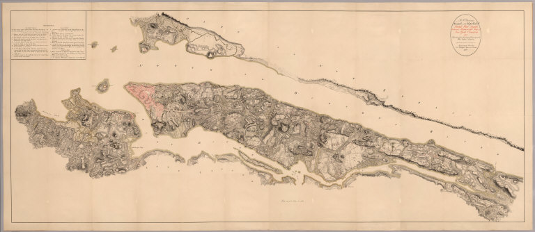
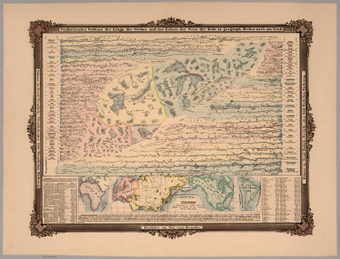
Author
[U.S. Northern Boundary Commission, Campbell, A.]
Full Title
(Title Page) Joint Maps Of The Northern Boundary Of The United States, From The Lake Of The Woods To The Summit Of The Rocky Mountains. United States Northern Boundary Commission, Archibald Campbell Esq. Commissioner. W.J. Twining, Capt. of Engrs, U.S.A. Chief Astronomer. Her Majesty's North American Boundary Commission, D.R. Cameron, Maj. Royal Art. Commissioner. S. Anderson, Capt. Royal Engrs. Chief Astronomer.
List No
3146.002
Note
Includes landscape vignette of Chief Mountain in present day Glacier National Park. The mountain appears on Sheet XXIV.
Author
[Howden, J.A., Odbert, A.]
Full Title
(Title Page) Howden & Odbert's Atlas Of Warren County, Pennsylvania. From Actual Surveys & Records by & under the directions of J.A. Howden & A.O. Odbert, Publishers, Washington, Pa. 1878. Assisted by J.J. Power, T.M.D. McCloy, F.G. Longdon, Capt. W.H. Horn. Artists, Wilson Porter, F. Robejohn, E. Bott, & M.B. Leisser. Engraved, Lithographed & Printed By Otto Krebs, Pittsburgh, Pa.
List No
4753.002
Note
Includes portrait vignette of Henry R. Rouse, a legislator so honored because on his deathbed, due to an explosion of gas from one of his oil wells, he executed a will very beneficial to the poor people of the county and the county infrastructure (see page 10).
Author
Bolitho, Edwin
Full Title
Leadville District, Colorado. No. 2. (to accompany) Pocket Mining Atlas. Compiled From The Latest Official Surveys, And The Most Authentic Sources. Edwin Bolitho, Engineering and Mining Journal, New York, 1880. Price, $1.00 per copy. (on following page) Entered ... 1880 ... Washington, D.C., by Trask & Francis, Bankers ... 70 Broadway, New York ...
List No
3054.015
Note
Full color map. Showing Leadville District and surroundings.
Author
[Mainwaring, C., Henderson, C.F.]
Full Title
(Title Page) Log Of H.M.S. "Swiftsure" Bearing the (flag of) Rear Admiral H.M.L. Lyons commanded by Captain C. Mainwaring. C.F. Henderson.
List No
5124.004
Note
Illustrated with flags and anchors. Color.
Author
[Henderson, C.F., Brand, T.S.]
Full Title
HMS Swiftsure, Panama to Payta, Jan 1885.
List No
5124.070
Note
Map tipped in on sheet smaller than pager.
Author
[Henderson, C.F., Brand, T.S.]
Full Title
HMS Swiftsure, Mazatlan to San Blas, Dec 1884.
List No
5124.056
Author
[Henderson, C.F., Brand, T.S.]
Full Title
(Section Title Page) Log of H.M.S. 'Swiftsure" Bearing the (Flag) of Rear Admiral J.K.E. Baird commanded by Captain the Honble T.S. Brand kept by C.F. Henderson.
List No
5124.035
Author
[Mainwaring, C., Henderson, C.F.]
Full Title
HMS Swiftsure. Esquimalt to Burrard Inlet.
List No
5124.017
Author
Haack, Hermann
Full Title
Schulwandkart von Afrika.
List No
7046.000
Note
Date estimated. Suitable for use in a large lecture hall; viewable to and beyond 40 feet. Language(s): German. Map is paper on muslin. Mounted on wood rods. Prime Meridian is Greenwich. Projection is not specified. Length of rolled wall map is 172 cm. Topics include: topography, hydrography, colonial territories. Department of Geography, University of California at Berkeley, Call Number 400-A-2.
Author
Rand McNally & Co.
Full Title
Western Hemisphere.
List No
6085.000
Note
Wall map. Classroom political map. Various small thematic maps alone margins.
Author
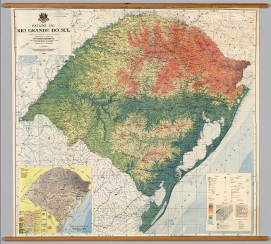
Instituto Gaucho de Reforma Agraria
Full Title
Estado do Rio Grande do Sul.
List No
7021.000
Note
Suitable for use in a standard classroom; viewable up to 40 feet. Language(s): Portugese. Map is paper on muslin. Mounted on wood rods. Prime Meridian is Greenwich. Length of rolled wall map is 116 cm. Topics include: topography, hydrography, geomorphology, external political boundaries. Department of Geography, University of California at Berkeley, Call Number 834-A-7.
Author
Denoyer-Geppert Company
Full Title
Sectional Map of the United States, Southwestern/Northwestern United States.
List No
7127.000
Note
Date estimated. Suitable for use in a large lecture hall; viewable to and beyond 40 feet. Language(s): English. Map is paper on muslin. Mounted on wood rods. Prime Meridian is Greenwich. Projection is Lambert's conformal conic. Length of rolled wall map is 171 cm. Part of a series entitled, Denoyer-Geppert Visual-Relief Series. Topics include: topography, hydrography, internal/external political boundaries, transportation routes, cities and towns. Department of Geography, University of California at Berkeley, Call Number 600-A-21.
Author
Muermann, H.
Full Title
California, Nevada.
List No
7136.000
Note
Suitable for use in a large lecture hall; viewable to and beyond 40 feet. Language(s): English. Mounted on wood rods. Prime Meridian is Greenwich. Projection is not specified. Topics include: topography, hydrography, internal political boundaries, cities and towns, transportation routes, canals - oversized map. Department of Geography, University of California at Berkeley, Call Number 611-A-4.
Author
Anonymous
Full Title
(California -- Physical)
List No
7033.000
Note
Suitable for use in a standard classroom; viewable up to 40 feet. Language(s): English. Map is paper on muslin. Mounted on wood rods. Projection is not specified. Topics include: shaded relief, cities, "birds eye" picture of plaster model of California. Department of Geography, University of California at Berkeley, Call Number 611-A-9.
Author
[Heezen, Bruce C., Tharp, Marie, United States Navy Office of Naval Research, Lamonat Doherty Geological Observatory, de Rémur, Tanguy]
Full Title
The Floor of the Oceans.
List No
7048.000
Note
Suitable for use in a seminar room; viewable up to 20 feet. Language(s): English. Map is plasticized paper. Mounted on wood rods. Prime Meridian is Greenwich. Projection is Mercator. Topics include: topography of land and ocean floors. Department of Geography, University of California at Berkeley, Call Number 1-F-3.
Author
Instituto Geografico Militar de Chile
Full Title
Mapa de Chile.
List No
7051.000
Note
Suitable for use in a standard classroom; viewable up to 40 feet. Language(s): Spanish. Map is paper on muslin. Mounted on wood rods. Prime Meridian is Greenwich. Projection is Polyconic. Length of rolled wall map is 60 cm. Part of a series entitled, No. 32570. Topics include: topography, hydrography, internal and external political units. Department of Geography, University of California at Berkeley, Call Number 824-A-3.
Author
Haack, Hermann
Full Title
Nordamerika
List No
7121.000
Note
Suitable for use in a standard classroom; viewable up to 40 feet. Topics include: topography, hydrography. Department of Geography, University of California at Berkeley, Call Number 500-A-7.
Author
Renner, George T.
Full Title
Rand McNally World Map for the Air Age.
List No
7078.000
Note
Suitable for use in a standard classroom; viewable up to 40 feet. Language(s): English. Map is paper on muslin. Mounted on wood rods. Prime Meridian is Greenwich. Projection is Azimuthal equidistant. Length of rolled wall map is 120 cm. Topics include: outline map, airline and air commerce routes 1942. Department of Geography, University of California at Berkeley, Call Number 1-Z-1.
Author
[Eggertsson, Samuel, Forlag, V. Richters, Danish General Staff]
Full Title
Island, Landslagsuppdrattur (Fysisk Kort, Physical Map).
List No
7050.000
Note
Suitable for use in a standard classroom; viewable up to 40 feet. Language(s): English, Icelandic, Danish. Map is paper on muslin. Mounted on wood rods. Prime Meridian is Greenwich. Projection is not specified. Length of rolled wall map is 125 cm. Part of a series entitled, Skolakort I. Topics include: topography, hydrography, vegetation, human features, internal political boundaries, administrative and political. Department of Geography, University of California at Berkeley, Call Number 165-A-1.
Author
[Rothaug, J.G., Umlauft, Friedrich, Freytag & Berndt]
Full Title
Schulwandkarte der Ostlichen Erdhalfte.
List No
7080.000
Note
Date is estimated. Suitable for use in a standard classroom; viewable up to 40 feet. Language(s): German. Map is paper on muslin. Mounted on wood rods. Prime Meridian is Greenwich. Projection is not specified. Length of rolled wall map is 181 cm. Topics include: hemispheric view, topography, hydrography, political boundaries, bathymetry. Department of Geography, University of California at Berkeley, Call Number 10-A-5.
Author
[Rothaug, J.G., Umlauft, Friedrich, G. Freytag & Berndt]
Full Title
Schulwandkarte der Westlichen Erdhalfte.
List No
7092.000
Note
Date estimated. Suitable for use in a standard classroom; viewable up to 40 feet. Language(s): German. Map is paper on muslin. Mounted on wood rods. Prime Meridian is Greenwich. Projection is not specified. Length of rolled wall map is 181 cm. Topics include: hemispheric view, topography, hydrography, political boundaries, bathymetry. Department of Geography, University of California at Berkeley, Call Number 20-A-5.
Author
USGS (U.S. Geological Survey)
Full Title
Yosemite, Calif.
List No
6226.000
Note
Edition of 1909. 30-minute topographic quadrangle with relief shown as contours. Includes areas of Merced River, Wawona, Hetch Hetchy Reservoir.
Author
Stieler, Adolf
Full Title
(Index Map) Die gegenwartige ubersicht der 50 Blatter aus welchen der Hand - Atlas besteh. A. Stieler del., L. Michaelis in Gotha sc. (on upper right margin) Hand Atl. No. 2 (to accompany) Hand-Atlas uber alle Theile der Erde, nach dem neuesten Zustande und uber das Weltgebaude.
List No
6830.003
Note
Unusual index map that shows the rough shape and projection for each of the original 50 maps of the atlas. Stieler was one of the first to use this technique for a visual index instead of listing the maps in text only. Zero or first edition of Stieler Atlas published 1817-1833 in three versions. 1817-23 (version 0.a), 1823-31 (version 0.b), 1831-33 (version 0.c). Publication went through ten editions from 1816 to 1944. This version published in 2 parts then augmented with two further supplementary installments, through 1833. Most maps have the year of first edition. This edition compromises 90 sheets, dated 1816-1835, including composite index map, and extraordinarily detailed maps and supplements. Maps are copper-plate engravings, hand colored in outline, mounted on cloth backing. Bound in marble papered, half leather covers with no title on cover. Inset map on title page: Gotha und Umgebung 1823 ; gest. v. Edler. Gez. v. Bar.
Author
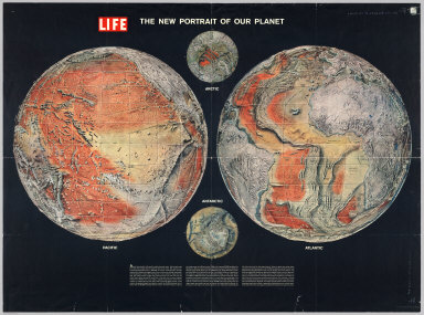
Time Inc.
Full Title
The New Portrait of our Planet. Life.
List No
6369.000
Note
A Life magazine publication. Hemispheric projection.
Author
Sonnenstern, Maximilian von
Full Title
Mapa general de la Republica de Guatemala. Publicado por Maximilian v. Sonnenstern por orden del gobierno, 1859. Printed by J. Rau, 33 Broadway, N.Y. G. Kraetzer lith, East New York Long Island, N.Y. "Entered according to act of Congress in the year 1859 by M.v. Sonnenstern ... New York." (insets) Plano de la ciudad de Guatemala; and 6 relief profiles.
List No
6850.002
Note
Color map, on sheet 90 x 92 cm. folded to 19 x 13 cm. in brown cover with gild title " Mapa de Guatemala. Includes: Nota. "El mapa de la Republica de Guatemala levantado por August van de Gehuchte y examinado y revisado en sus puntos principales topograficos segun las ordenes del S.G. por Maximilian v. Sonnenstern." Relief shown by hachures. Sonnenstern's map is one of the most detailed an up to date maps of Guatemala published in the 19th Century. The map was published at the request of the Government of Guatemala. In 1858, Maximilian Sonnenstern, received an exclusive privilege to manufacture paper in the Republic of Guatemala. He also received a contract to produce the first modern map of Guatemala, Sonnenstern was assisted by Agustin Van de Gehuchte, a Beglian Civil Engineer residing in Guatemala City, who was active in the surveying and planning of a number of road, bridge and port building projects for the Guatemalan Government.The map includes an inscription from Colonel Charles Bulkley to E. Hagen, "Rememberance from one scoundrel to the other . . . Guata. Nov 13 / [18]87." Bulkley's last work would seem to have been surveying work done for the Guatemalan Government in connection with the Intercontinental Railway, which included soundings taken in Lake Atiltlan. Includes hand written remembrance note inside front cover.
Author
Arrowsmith, Aaron
Full Title
Ireland. London, Published 4th January 1811 by A.Arrowsmith, Hydrographer to H.R.H. the Prince of Wales, No. 10 Soho Square.
List No
6708.000
Note
Dissected and mounted on linen. Engraved by Edward Jones; outlines handcoloured.
Author
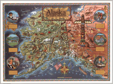
Rude, Klengston
Full Title
Alaska: Far North frontier. Published and distributed by Alaska Arts. Kleng Rude Studio - P.O. Box 1378 Studio City, California. Copyright 1959 R. Klengston Rude Hollywood 38, California.
List No
6822.000
Note
Color pictorial map of Alaska, published the year Alaska officially became the 49th state of the United States of America. Showing rivers, straits, sounds, towns, mountain ranges (drawn in aerial perspective), glaciers (shaded white), and existing and proposed highways. The map is richly illustrated with naturalistic depictions of wildlife, agricultural products, historical landmarks, oil fields and fisheries. Along the left and right sides, six circular illustrations highlight important events in Alaskan history beginning with Vitus Bering's 1741 explorations and ending with Alaska statehood in 1959. A compass rose over the Gulf of Alaska incorporates the American and Alaskan flags. Includes a section of the Canadian provinces of British Columbia, Yukon and the Northwest Territories to the east, which are depicted in less detail and dominated by a large illustration of a Native American totem pole. The map border is rendered in a geometric beadwork design, inspired by artwork of indigenous Northwest Coast tribes.
Author
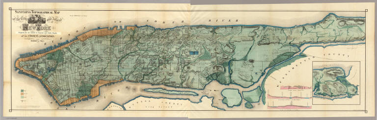
Viele, Egbert L.
Full Title
Sanitary & Topographical Map of the City and Island of New York Prepared for the Council of Hygiene and Public Health of the Citizens Association. Under the direction of Egbert L. Viele, Topographical Engineer. Entered ... 1865 by Egbert L. Viele ... New York. Ferd. Mayer & Co. Lithographers, 96 Fulton St. N.Y. (with 1 inset map and 3 profiles).
List No
3723.000
Note
For some reason Haskell and Stokes date this map 1864 although it was copyrighted by Viele in 1865. Removed from the Report of the Council of Hygiene (see our copy). The map shows all the original water courses of Manhattan Island, with the street grid superimposed on top. Also, three different kinds of land are shown: Marsh, Made Land, and Meadow. Sewer lines are indicated. A very beautiful full color map occasioned by a not so beautiful subject. In 1874 Viele reissued the map in larger format as the Topographical Atlas of the City of New York (see our copy). This map was also published as a separate pocket map, in covers.
Author
[Woerl, Joseph Edmund, Herder, Benjamin]
Full Title
(Composite of) Sheets 1 - 12 Das Koenigreich Wuerttemberg Das Grossherzogthum Baden und die Fuurstenthuumer Hohenzollern : entworfen und bearbeitet im Maasstabe 1:200 000 in 12 Blaettern von I.E. Woerl.
List No
6829.016
Note
All 12 sheets of the Wuerttemberg map joined together.
Author
[Woerl, Joseph Edmund, Herder, Bartholomew]
Full Title
(Composite of) Sheets 1 - 20 of Karte der Schweiz, von Dr. I. Woerl. Lithographie von B. Herder in Freiburg im Breisgau.
List No
6824.023
Note
Composite of all 20 sheets. Red lithographic stone printing on map. Shows cities, roads, fortifications, canals, major public buildings, etc. Relief shown by Form lines and spot heights. <a href=http://www.davidrumsey.com/view/google-earth-browser#switzerland-1835 target=_blank>View in Google Earth</a>
Author
Santa Fe Railroad
Full Title
Map of Part of California Compiled from Various Sources.
List No
6725.000
Note
Blue print map of northern California up to the Sierra Nevada. This was probably an internal planning map for the Santa Fe Railroad, showing four different railroad routes from the east Bay and Sonoma County north to Humbolt County. Also shows towns, railroads, townships, wagon roads, unsurveyed lands, mountains and the Redwood Belt. This map came from the archive of the Santa Fe Railroad.
Author
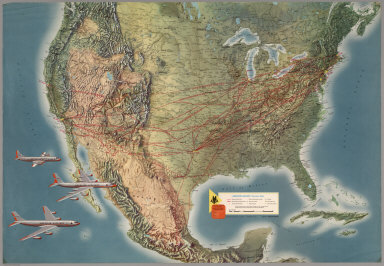
Rand McNally and Company
Full Title
American Airlines System Map.
List No
6371.000
Note
Map has shaded relief. Includes illustrations and descriptions of aircraft, sights, cities, landscapes, geology, and aerial views. Astrojet.
Author
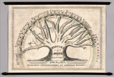
Willard, Emma
Full Title
Willard's Chronographer of American History. History of the U. States or Republic of America. Historic Tree.
List No
6700.000
Note
Willard uses the Historic Tree as a visualization of important events in American history. A smaller version of this diagram appears in one of her text books. Willard sums up her goal with this chart: "The eye is the only medium of permanent impression. The essential point in a date, is to know the relative place of an event, or how it stands in time, compared with other important events."
Author
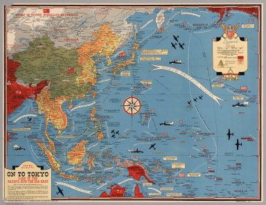
[Turner, Stanley, Petersen, C.C.]
Full Title
Dated Events. On To Tokyo. Map of the Pacific and the Far East. Stanley Turner, 44. Copyright, Canada and U.S.A., 1944, C.C. Petersen, Publishing and Advertising, Toronto, Canada. Seventh Edition.
List No
6828.000
Note
Color map, seventh edition, showing the latest activity in the Pacific Arena. On sheet 51x 66, folded as issued. Date of 1944 in marker at lower left corner. Note below title: "With this invasion map you will be able to follow the progress of the Allied armies on their way to smash Japan ..." Legend includes: American, British, Russian and Japanese Naval Bases are shown; land areas are colored to show countries under Anglo-American control, those retaken from Japan, and those under Japanese control. A fascinating map packed with information on battle dates and illustrations. Relief shown pictorially. From the collection of John Oram.
Author
[Great Britain. War Office, Stevens, Benjamin Franklin]
Full Title
(Composite of) B.F. Steven's Facsimile of the Unpublished British Head Quarters Coloured Manuscript map of New York & Environs, 1782, Reproduced from the original drawing in the War Office, London. Issued only to subscribers at 4, Trafalgar Square, W.C., London. 1900. Malby and Sons. Engravers.
List No
6403.004
Note
(Composite removing linen gaps between sections). From the printed advertisement for the map: "BF STEVENS'S Facsimile of the Unpublished British Headquarters Coloured Manuscript Map of New York and Environs 1782. Reproduced from the Original Drawing in the War Office London. 24 sheets Scale 6 1/2 inches to a mile. 10 feet by 4 feet. The successive British Commanders in Chief in America Generals Sir William Howe, Sir Henry Clinton, and Sir Guy Carleton during their respective occupations of New York and Environs in the Revolution caused this manuscript plan from time to time to be kept up. The plan extends from below Guanas Bay to the Heights of Spikendevi, a distance of about eighteen or nineteen miles. It shows the Fortifications, Defenses, Topography, Streets, Roads, etc. of the whole of the Island of New York with the Harbor Islands, Water Ways, and River Frontages on the Hudson and East Rivers, the Military Works on Long Island including Brooklyn, the Works in Paulus Hook and parts of the Jersey Shore. It has a copious Table of References to various works British and American, some of them with notes as to the time of their construction or destruction. The Original Drawing, ten feet by four feet, is on a scale of about six and a half inches to a mile. It is handsomely reproduced for subscribers only in careful facsimile on 24 sheets which can be joined up and mounted like the original as a Wall Map or mounted on linen if desired. It will be issued either mounted on linen to fold in book form with leather slip case 13 x 10 inches or the 24 sheets 22 x 15 inches, each will be supplied in a portfolio. No more than 100 copies are being printed and the engravings are erased as each sheet is printed off. A few extra copies of sheet 8 have been printed so that it can be sent as a specimen on application from intending subscribers..." <a href=http://www.davidrumsey.com/view/google-earth-browser#new-york-1782 target=_blank>View in Google Earth</a>
Author
[California Geological Survey, Hoffmann, Charles F., Whitney, J.D.]
Full Title
(Composite) Topographical Map of Central California Together With a Part of Nevada. (Sheets I, II, III & IV). State Geological Survey Of California. J.D. Whitney, State Geologist. C.F. Hoffmann, Principal Topographer, V. Wackenreuder, J.T. Gardner, A. Craven, A.D. Wilson, Field Assistants. 1873 ... Julius Bien, Engr.
List No
2546.006
Note
Four sheets. South 2 sheets of 4; top 2 sheets apparently were never issued but were printed. Four unmounted sheets on heavy paper. Never folded.
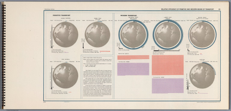
Author
[United States Army Service Forces, Office of the Geographer, Department of State]
Full Title
Relative Efficiency of Primitive and Modern Means of Transport 23.
List No
6351.037
Note
1073-G. A set of fascinating diagrams exhibiting transport efficiency for human porters, pack animals, horse teams, railroad, liberty ship, truck and ariplane.
Author
[Isaacs, John D., Bascom]
Full Title
Cape Blanco.
List No
6349.026
Note
Black and white, oblique air photo looking east, taken October 3, 1947.
Author
Stieler, Adolf
Full Title
(Composite of) Nos. XXI, XXVII, XXIX, XXXI, XXXII. Stieler's Hand-Atlas Deutschland ....
List No
2507.127
Note
Composite of five maps of parts of Germany.
Author
[Woerl, Joseph Edmund, Herder, Benjamin]
Full Title
(Title Page to) Das Koenigreich Wuerttemberg Das Grossherzogthum Baden und die Fuurstenthuumer Hohenzollern : entworfen und bearbeitet im Maasstabe 1:200 000 in 12 Blaettern von I.E. Woerl ; in Stein gestochen unter seiner Leitung. Eine Abteilung der von Obrist Weiss entworfenen Karte von Suddeutschland. In tiefster ehrfurcht aller untertanigst gewidmet von H. Heder. [Gewidmet] Grosherzog Leopold von Baden. Woerl dir: 1831. Im Herder'schen Kunst-Institut in Freburgn im Breisgan. (at head of title) 1830.
List No
6829.002
Note
Title framed with decorative illustrations, sample maps, and coat of arms. Maps of southwesterm Germany by Joseph Edmund Woerl, mapmaker in Freiburg 1830-1838. An important document about the road network. Red lithographic stone printing. In 23 parts (20 maps 43x46, a title page with decorative illustrations, sample maps and coat of arms, index sheet, and table) placed in cardboard case 54x64, with title "Woerl Atlas der Wuerttemberg." All the maps are at the same scale (1:200,000) and fit together into either one very large composite of all 48 maps or sub-maps of Switzerland (19 sheets plus title, see our 6824.000), Wurtttemberg (12 sheets including title) and Baden. We do not have all 48 maps but rather 24 in this group and 19 in the Switzerland group (although 3 maps appear in both groups, so our net total maps is 39 of 48).
Author
[Woerl, Joseph Edmund, Herder, Benjamin]
Full Title
Constanz - Lindau. Entworfen und bearbeitet von Woerl, gestochen unter seiner Leitung 1834. Lithographie von B. Herder in Freiburg im Bresgau. (to accompany) Das Koenigreich Wuerttemberg Das Grossherzogthum Baden und die Fuurstenthuumer Hohenzollern.
List No
6829.015
Note
Red lithographic stone printing map. Shows roads, fortifications, canals, major public buildings, etc. Relief shown by form lines and spot heights.
Author
Bancroft, A.L.
Full Title
Bancroft's new map of California and Nevada : compiled from the latest and most reliable official sources and special surveys.
List No
6724.002
Note
Includes a unique birdseye view of Virginia City, Nevada. This map derives from H. H. Bancroft's 1867 Map of the Pacific States (see our 2549.000) but now focuses on just California and Nevada and the extensive and growing mining activity and transportation networks in those states. It is an entirely new engraving from the earlier map series and uses color lithography. With an inset map, Railway Map of the Pacific States.
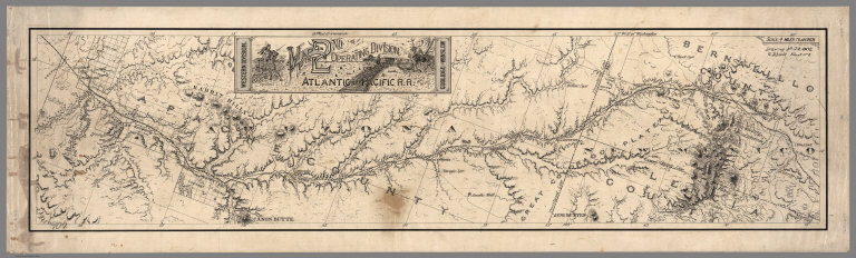
Author
Atlantic & Pacific Railroad
Full Title
Map of the 2nd Operating Division of the Western Division, Atlantic & Pacific R.R., From Coolidge to Winslow. Drawing No. J-2-902.
List No
6929.002
Note
Lavishly illustrated title block. No drawing on verso. A set of six hand-drawn maps on semi-transparent waxed linen with some color. Some areas are colored on the verso to highlight the areas in a muted style. We think that some type of backlighting was planned to be used to create a photolithographic plate from which printing would be done. No evidence was found that it was ever printed. These sheets were deaccessioned from the Santa Fe Railroad collection in the 1980s. Lewis Kingman did the route survey from Albuquerque to Needles. Relief shown by hachures.
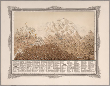
Author
Desjardins, Constant
Full Title
Vergleichendes Tableau der bedeutendsten Hoehen der Erde, von Prof. C. Desjardins. 4te Auflage. Munchen 1855. Zu haben in Wien bei Joseph Bermann am Graben (fur ganz Osterreich.), in Munchen bei May und Widmayer (fur Deutschland). Eigentum des Verfassers.
List No
6844.001
Note
Rare color chart framed in decorative borders. Showing comparative table of the greatest Mountains and Volcanoes of the world. Extensive table indicating their relative heights with corresponding numbers.
Author
Desjardins, Constant
Full Title
Vergleichendes Tableau der Lange der Strome und der Grosse der Seen der Erde in geograph. Meilen zu 15 am Grad. Kartchen zur Berichtigung des wahren Laufes der Strome des Tableau mit den correspondirenden Rangs-Zahlen. Bearbeitet von Prof. Const. Desjardins. Verlag von J. Bermann. Ged., bei. L. Forster. (with 3 insets) Afrika. Europa, Asien, Nord Amerika. Sud Amerika.
List No
6843.001
Note
Rare color chart framed in decorative borders. Showing comparative table of the length of the rivers and lakes of the world. The lakes and rivers of the Eastern Hemisphere are shown on the left, with lakes and rivers of the Eastern Hemisphere on the right. Includes notes, and tables indicating correct run of the currents with corresponding numbers.
Author
[Gibbes, C.D., Holt, Warren]
Full Title
Map of the States of California and Nevada. Carefully Compiled from the Latest Authentic Sources. California by Julius H. Von Schmidt, Arthur W. Keddie, and C.D. Gibbes, C.E.'s. Nevada by Chas. Drayton Gibbes C.E. Comprising Information obtained from the U.S. Coast and Land Surveys; State Geological Surveys, By Prof. J.D. Whitney; Railroad Surveys And The Results of Explorations Made By Brevet Lieut. Col. R.S. Williamson, U.S.A., Henry DeGroot, C.D. Gibbes, And Others. Entered ... 1876 by Warren Holt ... California.
List No
6716.000
Note
Third (?) edition. Some changes from the 1871 edition. Wheat does not list editions later than 1869, and Vogdes only lists 1869, 1876, and 1882.
Author
Schweickhardt, Franz Xaver
Full Title
I, II, III, IV Sections. Umgebung von Wien.
List No
6936.003
Note
Date estimated. The first four Sections are joined and mounted together on linen. These birdseye views when joined together (see our Composite) make probably the largest such view of any country that we have seen. Together they cover about 3,000 square miles at a large scale of two inches to one mile. They give a unified view of the landscape that is at a consistent scale (unlike other birdseyes that use diminishing perspective), and the level of detail of cultural information is extraordinary. <a href=http://www.davidrumsey.com/view/google-earth-browser#austria-1837 target=_blank>View in Google Earth</a>
Author
Schweickhardt, Franz Xaver
Full Title
VII Section. Umgebung von Korneuburg, Klosterneuburg und St. Andra. Hyrtl sculp.
List No
6936.009
Note
Date estimated. These birdseye views when joined together (see our Composite) make probably the largest such view of any country that we have seen. Together they cover about 3,000 square miles at a large scale of two inches to one mile. They give a unified view of the landscape that is at a consistent scale (unlike other birdseyes that use diminishing perspective), and the level of detail of cultural information is extraordinary. <a href=http://www.davidrumsey.com/view/google-earth-browser#austria-1837 target=_blank>View in Google Earth</a>
Author
Deutsche Seewarte
Full Title
Wassertemperatur in 400 m tiefe. Verlag von L. Friederichsen & Co., Hamburg. Geogr. Anstalt von Wagner & Debes, Leipzig. (on the upper left margin) Atlantischer Ozean.
List No
6831.011
Note
Full color map. Show water temperature in various depth. Includes legend. Depth of ocean shown by gradient tints and soundings. Prime meridian is Greenwich.
Author
Deutsche Seewarte
Full Title
Wetterlagen auf dem Nordatlantischen Ozean. Nach der lage der Hochdruckgebiete. Verlag von L. Friederichsen & Co., Hamburg. Photolithorgaphie. (on the upper left margin) Atlantischer Ozean.
List No
6831.028
Note
21 color maps on one page.
|