Author
Cushee, Richard
Full Title
A New Globe of the Earth by R. Cushee 1731.
List No
3992.000
Note
Scarce 3 inch diameter pocket globe in black fishskin case lined with colored celestial gores. California is shown as an island, and eastern Australia is not mapped. A very early example of a pocket globe.
Author
Moll, Herman, d. 1732
Full Title
America. By H. Moll Geographer. (Printed and sold by T. Bowles next ye Chapter House in St. Pauls Church yard, & I. Bowles at ye Black Horse in Cornhill, 1736?)
List No
5580.045
Note
Hand col. engraved map. Relief shown pictorially.
Author
Bowen, Emanuel
Full Title
A new & accurate map of Mexico or New Spain together with California, New Mexico &c. Drawn from the best modern maps & charts & regulated by astronl. observns. By Eman: Bowen. (London: Printed for William Innys, Richard Ware, Aaron Ward, J. and P. Knapton, John Clarke, T. Longman and T. Shewell, Thomas Osborne, Henry Whitridge ... M.DCC.XLVII)
List No
3733.057
Note
Engraved map. Shows shoals, etc. Includes historical note on California and ornamental cartouche. Relief shown pictorially. Inset map: The Gallipago Islands : discovered & described by Capt. Cowley in 1684. Scale [ca. 1:5,000,000]
Author
Jefferys, Thomas
Full Title
A Map of the most Inhabited part of New England, containing the Provinces of Massachusetts Bay and New Hampshire, with the Colonies of Conecticut And Rhode Island, Divided into Counties and Townships: The Whole composed from Actual Surveys and its Situation adjusted by Astronomical Observations. (with) A Plan of the Town of Boston. November 29th 1774. Published according to Act by Thos. Jefferys Geographer to His Royal highness the Prince of Wales near Charing Cross. (Northern section)
List No
0346.017
Note
Northern part of map in two sheets. In outline color except for section to the west of the Connecticut River, which is in yellow.
Author
[Blaskowitz, Charles, Faden, William, 1750?-1836]
Full Title
A Topographical Chart of the Bay of Narraganset in the Province of New England, with all the Isles contained therein, among which Rhode Island and Connonicut have been particularly Surveyed, Shewing the true position & bearings of the Banks, Shoals, Rocks &c. as likewise the Soundings: To which have been added the several Works & Batteries raised by the Americans. Taken by Order of the Principal Farmers on Rhode Island, By Charles Blaskowitz. Engraved & Printed for Wm. Faden, Charing Cross, as the Act directs, July 22d 1777. To the Right Honourable Hugh Earl Percy, Baron Percy, Lucy, Poinings, Fitz-Paine, Bryan & Latimer, Lieutenant General of His Majesty's Forces in Great Britain and America. This Plan is ... most humbly Inscribed, by ... Wm. Faden. (in manuscript) Hinck S.
List No
3951.001
Note
The most important map of the area around Providence and Newport issued during the Revolution. With hand painted color. A separately issued copy dissected into 16 sections and mounted on linen. Folds into a marbled slip case 24x17 with a paper label with "Rhode Island" printed in manuscript.
Author
Hutchins, Thomas
Full Title
A New Map of the Western Parts of Virginia, Pennsylvania, Maryland and North Carolina; Comprehending the River Ohio, and all the Rivers, which fall into it; Part of the River Mississippi, the Whole of the Illinois River, Lake Erie; Part of the Lakes Huron, Michigan &c. And all the Country bordering on these Lakes and Rivers. By Thos. Hutchins, Captain in the 60 Regiment of Foot. London, Published according to Act of Parliament Novembr. ye 1st, 1778 by T. Hutchins ... Engrav'd by T. Cheevers.
List No
5044.000
Note
This map was published separately and at the same time as Hutchins' "Topographical Description..." and should accompany the book. Streeter calls it "by far the best map of the west printed to that time." It was the first large scale map of the area west of the Allegheny Mountains based on personal observations, although Hutchins gives credit to Lewis Evans' "Map of the Middle Colonies" as the best prior source of information about the area. The map contains extensive printed notes which describe important aspects of the country depicted. This map ranks with the most important American maps issued in the 18th century and is now rare. Hutchins later became the first Geographer of the United States. With outline color. Map is dissected into 32 sections and mounted on linen. Folds into new green cloth folding boards and quarter leather green cloth slip case 24x16 with "Hutchin's New Map Of Western Parts Of Virginia, Etc. 1778" on the spine in gold.
Author
Cook, James, 1728-1779
Full Title
Chart of Norton Sound and of Bherings Strait made by the East Cape of Asia and the West Point of America. (Copied by Lieut. Henry Roberts. London, G. Nicol and T. Cadell, 1785)
List No
3405.016
Note
Engraved nautical chart. Relief shown pictorially; depths by soundings. Shows ship's track, etc. David contains a quote from Capt. Bligh (from Gould, 1928, p. 377), "Here is a gross mistake for Anderson's & the east end of Clerk's Island is one & the same land, and how they have blundered to lay them down as two I cannot conceive"
Author
[Cook, James, 1728-1779, Webber, John, 1751-1793]
Full Title
A view of Huaheine. J. Webber del. W. Byrne sculp. (London, G. Nicol and T. Cadell, 1785)
List No
3405.048
Note
Engraved illustration. Shows islanders on shore and in boats, British ships, harbor, vegetation, hills in background.
Author
Colles, Christopher
Full Title
From Philadelphia to Annapolis Md. (56)
List No
2467.053
Note
Without color.
Full Title
(Deed from the state of New York, signed by Governor George Clinton, Granting 600 acres of land to Thomas Garrison in the township of Cincinnatus, Montgomery County).
List No
4401.000
Note
An early deed with the large (9cm diameter) seal of the state attached. The State granted lands in what was designated as the Military Tract to Revolutionary War veterans. The tract comprised twenty five townships of 60,000 acres each, each consisting of 100 lots of 600 acres. Grantees received one lot. Thomas Garrison was granted lot 80 of Township 25, Cincinnatus, by this deed. In 1793, Simeon DeWitt produced a map of the Military Tract, one of his first surveys. The Military Tract was one of the first uses of Township surveys built on square lots of uniform size. Eventually, the U.S. Land Office used a 660 acre unit (1 mile square) as the building block for its surveys in Ohio and westward. Printed form filled in with pen-and-ink and including the signature of Geo. Clinton.
Author
[Carey, Mathew, Lewis, Samuel]
Full Title
The State of New York Compiled from the best Authorities, By Samuel Lewis. 1795.
List No
2542.008
Note
Uncolored.
Author
Reid, John
Full Title
Plan of the City of Washington in the Territory of Columbia ceded by the States of Virginia And Maryland to the United States of America and by them established as the Seat of their Government, after the Year 1800. Rollinson sculp. N. York. Published by J. Reid L. Wayland and C. Smith 1795.
List No
5160.000
Note
State I of this map (State II lists only J. Reid as publisher). This map is taken from the first official plan of Washington published by Andrew Ellicott in 1792 (see Wheat & Brun 531). The Reid map is not an exact copy, with the title moved from the upper right to the lower left, several notes not included, and other elements moved. An exact copy of Reid's map appears in the London edition of Winterbotham's "View of the United States of America" (see our #3885). Howes gives precedence to the London edition, so it is not clear if Reid or Russell copied the Ellicott first. The Reid American Atlas index does not call for the Washington map, leading to the assumption that it was added to some copies afterwards, and speculation that it may have been sold as a separate. Scarce.
Author
[Collot, George Henri Victor, Tardieu, P.F.]
Full Title
Map of the Country Of The Illinois. PL. 28.
List No
4664.018
Note
A superbly detailed map of the Mississippi River from the junction with the Illinois to the junction with the Kaskaskias River, especially good in the area around St. Louis. Uncolored.
Author
[Bernizet, Sebastien, La Perouse, Jean-Francois de Galaup, comte de, 1741-1788]
Full Title
Details geometriques, des monumens de l'Ile de Paque. Dessine par Bernizet. Grave par Hulk. L. Aubert, scripsit. Atlas du Voyage de la Perouse, no. 12. (Paris: L'Imprimerie de la Republique, An V, 1797)
List No
3355.012
Note
Nine engraved views and plans. Contents: Fig. 1. Plan d'une Case en pierre -- Fig. 2. 1re. Coupe de la Case en Pierre, prise sur la ligne D.D. -- Fig. 3. 2e. Coupe de la Case en pierre, prise sur la ligne X.X. -- Fig. 4. Elevation de la Case en pierre -- Fig. 5. Plan d'une Grande Case -- Fig. 6. Carcasse de la Grande Case -- Fig. 7. Coupe de la Grande Case, prise sur la ligne F.F. -- Fig. 8. Plan d'un Morai ou Cimetiere -- Fig. 9. Elevation du Morai -- Fig. 10. Coupe du Morai, pris sur la ligne M.M.
Author
[Bernizet, Sebastien, La Perouse, Jean-Francois de Galaup, comte de, 1741-1788]
Full Title
Plan de la Baie de la Conception, situee dans le Chili par 36042'21" de latitude sud et 75020' de longitude orientale. Dressee pour servir au Voyage de M. de La Perouse. Leve par Bernizet. L. Aubert scripsit. Atlas du Voyage de la Perouse no. 4. (Paris: L'Imprimerie de la Republique, An V, 1797)
List No
3355.004
Note
Engraved map. Relief shown by hachures; depths by soundings. Oriented with north toward left.
Author
[Blondela, Lieut., La Perouse, Jean-Francois de Galaup, comte de, 1741-1788]
Full Title
Vue du mouillage des Fregates Francaises a l'Ile de Mowee. Dessine par Blondela. Grave par Avril. L. Aubert, scripsit. Atlas du Voyage de la Perouse, no. 14. (Paris: L'Imprimerie de la Republique, An V, 1797)
List No
3355.014
Note
Engraved view of La Perouse's ships at Maui.
Author
[Blondela, Lieut., La Perouse, Jean-Francois de Galaup, comte de, 1741-1788]
Full Title
Vue d'un etablissement des habitans du Port des Francais pour la saison de la peche. Dessine par Blondela. Grave par Le Grand. L. Aubert scripsit. Atlas du Voyage de la Perouse, no. 21. (Paris: L'Imprimerie de la Republique, An V, 1797)
List No
3355.021
Note
Engraved drawing.
Author
La Perouse, Jean-Francois de Galaup, comte de, 1741-1788
Full Title
Costumes des habitans de la Conception. Dessine par Duche-de-Vancy. Reduit par J.M. Moreau le jeune. Grave par Thomas. L. Aubert scripsit. Atlas du Voyage de la Perouse, no. 5. (Paris: L'Imprimerie de la Republique, An V, 1797)
List No
3355.005
Note
Engraved view.
Author
[Duche de Vancy, Gaspard, La Perouse, Jean-Francois de Galaup, comte de, 1741-1788]
Full Title
Insulaires et monumens de l'Ile de Paque. Dessine par Duche de Vancy. Grave par Godefroy. Atlas du Voyage de la Perouse, no. 11. (Paris: L'Imprimerie de la Republique, An V, 1797)
List No
3355.011
Note
Engraved view.
Author
La Perouse, Jean-Francois de Galaup, comte de, 1741-1788
Full Title
(Title Page to) Atlas du voyage de La Perouse. Dessine par J. M. Moreau le Jeune. Grave par Ph. Triere. L. Aubert scripsit.
List No
3355B
Note
Engraved, illustrated title page. Some figures looking at unfolding map entitled: Developement de la route de La Perouse.
Author
La Perouse, Jean-Francois de Galaup, comte de, 1741-1788
Full Title
Carte du Grand Ocean ou Mer du Sud. Dressee pour la Relation du Voyage de Decouvertes faites par les Fregates Francaises la Boussole et l'Astrolabe dans les annees 1785, 86, 87, et 88. P.F. Tardieu sculp. Atlas du Voyage de la Perouse no. 3. (Paris: L'Imprimerie de la Republique, An V, 1797)
List No
3355.003
Note
Engraved map. Emphasizes coastal detail; shows route of La Perouse. Prime meridian: Paris.
Author
La Perouse, Jean-Francois de Galaup, comte de, 1741-1788
Full Title
Carte particuliere de la cote du nord-ouest de l'Amerique reconnue par les Fregates Francaises la Boussole et l'Astrolabe en 1786. 1e. feuille. Bouclet sculp. Herault scrip. Atlas du Voyage de la Perouse no. 17. (Paris: L'Imprimerie de la Republique, An V, 1797)
List No
3355.017
Note
Engraved map. Relief shown by hachures. Covers coast from Mt. St. Elias to Graham Island. Shows route of La Perouse. Prime meridian: Paris.
Author
La Perouse, Jean-Francois de Galaup, comte de, 1741-1788
Full Title
Vues de la cote du nord-ouest de l'Amerique reconnue par les Fregates Francaises la Boussole et l'Astrolabe en 1786. 1e. feuille. Atlas du Voyage de la Perouse, no. 18. (Paris: L'Imprimerie de la Republique, An V, 1797)
List No
3355.018
Note
Five engraved coastal views in 7 segments. Cover parts of the coast from Mt. St. Elias to Mt. Crillon (sections A-E)
Author
Vancouver, George, 1757-1798
Full Title
A Chart shewing part of the Coast of N.W. America, With the Tracks of His Majesty's Sloop Discovery and Armed Tender Chatham; Commanded by George Vancouver Esqr. and prepared under his immediate inspection by Lieut. Joseph Baker, in which the Continental Shore has been traced and determined from Latde. of 59¼30' North & Longde. 207¼20' East; to Cape Douglas in Latde. 58¼52' North and Longde. 207¼20' East. Engraved by S.J. Neele, 352 Strand. (with) A Survey of Port Chatham. London Published May 1st 1798, by T.R. Edwards Pall Mall & C. Robinson Paternoster Row.
List No
3354.010
Note
Maps without color. Note within the cartouche states, "The parts not shaded taken from Russian Authority." Unbroken lines show the ships' path as they went north. Dotted lines show the path of the ships as they sailed south. Map covers the area around Kodiak Island and the Kenai Peninsula in Alaska.
Author
Vancouver, George, 1757-1798
Full Title
A Chart shewing part of the Coast of N.W. America, with the tracks of His Majesty's Sloop Discovery and Armed Tender Chatham; Commanded by George Vancouver Esqr. and prepared under his immediate inspection by Lieut. Joseph Baker, in which the Continental Shore has been traced and determined from Lat. 45¼30'N. and Long. 236¼12' E. to Lat. 52¼15'N and Long 232¼40'E. at the different periods shown by the Tracks. Warner Sculp. 5. (with) three inset maps. London: Published May 1st 1798, by J. Edwards Pall Mall & G. Robinson Paternoster Row.
List No
3354.005
Note
Map uncolored and shaded. Note in the title cartouche states, "The parts not shaded are taken from Spanish Authorities." The large map shows the route north in unbroken lines, and the route south in dotted lines. Inset maps include: 1. Entrance of Columbia River 2. Gray's Harbour 3. Port Discovery. Map extends from Cape Lookout, Oregon in the south to Kings Island, British Columbia in the north.
Author
Vancouver, George, 1757-1798
Full Title
Views of Headlands and Islands on the Coasts of North West and South America. W. Alexander delt. from Sketches made on the spot. London: Published May 1st 1798, by J. Edwards Pall Mall & G. Robinson Paternoster Row. J. Fittler sculp.
List No
3354.013
Note
Numerous uncolored views of the coast, including Cook's Inlet at Port Chatham, Port San Blas, Mexico, and the Islet of Diego Ramirez to the south of Cape Horn.
Author
Vancouver, George, 1757-1798
Full Title
(Title Page to) A Voyage Of Discovery To The North Pacific Ocean And Round The World In Which The Coast of North-West America Has Been Carefully Examined And Accurately Surveyed. Undertaken by His Majesty's Command, Principally With A View To Ascertain The Existence Of Any Navigable Communication Between The North Pacific and North Atlantic Oceans; And Performed In The Years 1790, 1791, 1792, 1793, 1794, and 1795 In The Discovery Sloop Of War, And Armed Tender Chatham, Under The Command Of Captain George Vancouver. In Three Volumes. London: Printed For G.G. And J. Robinson, Paternoster-Row; And J. Edwards, Pall-Mall. 1798.
List No
3354B
Note
Title page from the first volume describing the voyages. Atlas volume was printed without its own title page.
Author
Espinosa y Tello, J.
Full Title
Carta Esferica de los Reconocimientos hechos en la Costa N.O. De America en 1791 y 92 por las Goletas Sutil y Mexicana y otros Buques de S.M. Numo. 2. Cardano lo Grabo.
List No
4476.002
Note
Map begins at Co. Perpetua and charts the region north to Vancouver Island. Detailed drawing of the island and the area around Puget Sound.
Author
[Jones, T.W., Moore, S.S.]
Full Title
Philadelphia and the commencement of the road to New York. 1. Shallus fc.
List No
2646.001
Note
Map without color.
Author
[Jones, T.W., Moore, S.S.]
Full Title
Road from Philadelphia to Washington. (Maps) 9, 10, 11 and 12. W. Harrison, Junr. sc.
List No
2646.008
Note
Four uncolored maps spanning two pages. Area from Charlestown to Abington shown.
Author
Varle, Charles P.
Full Title
To The Citizens Of Philadelphia This New Plan Of The City And Its Environs Is respectfully dedicated By the Editor. 1802. P.C. Varle Geographer & Enginr. Del.
List No
5006.000
Note
A beautiful, early map of Philadelphia in full period color. The scale is given at 75 Perches to 1 inch. The city is shown from the Delaware River to the Schuylkil River with the environs on the north and south. 24 lettered references and 28 numbered references to important places and buildings are below the title and 24 wards are keyed in Roman numbers above the title. Many of the country houses and farms around the city are named, including Penn, Dr. Wistar, and other notable early residents. Three inset views show City Hall, the State House, Court House, Library, and Bank of the United States. The tile is surrounded by a decorative cartouche. The quality of the engraving is superb. Ristow mentions an undated edition that was possibly issued in the year Varle made the surveys, 1796, but more likely in 1802. Wheat and Brun list a c.1794 State I that has one less numbered building reference, no Roman numbered ward references, and "R. Scott Sculp. Philadelphia." This was Varle's first map published in the United States. Until 1807, Varle was known as Peter C. Varle; after 1807 he is known as Charles P. Varle.
Author
Humboldt, Alexander von, 1769-1859
Full Title
(Composite Map of) Carte Generale Du Royaume De La Nouvelle Espagne depuis le Parallele de 16¼ jusqu'au Parallele de 38¼ (Latitude Nord). Dressee Sur des Observations Astronomiques et sur l'ensemble des Materiaux qui existoient a Mexico, au commencement de l'annee 1804. Par Alexandre de Humboldt. Ls. Aubert pere Scripsit. 1. and 1(bis). Dessine a Mexico par l'Auteur en 1804, perfectionne par le meme, par M.M. Friesen, Oltmanns, et Thuilier 1809. Grave par Barriere - et l'Ecriture par L. Aubert pere, a Paris.
List No
0328.003
Note
Composite map of Mexico. Without color.
Author
Pike, Zebulon Montgomery
Full Title
A Map of The Internal Provinces of New Spain. The Outlines are from the Sketches of but corrected and improved by Captain Zebulon M. Pike, who was conducted through that Country, in the Year 1807, by Order of the Commandant General of those Provinces.
List No
0730.004
Note
A large uncolored map stretching from the Baja peninsula to Nacogdoches in the east. Provincial boundaries, capitals of provinces or kingdoms, Indian and Spanish villages, and the American Troops route all shown in detail.
Author
Humboldt, Alexander von, 1769-1859
Full Title
Carte de Fausses Positions de Mexico, Acapulco, Veracruz et du Pic d'Orizaba. 10. Dessine par A. de Humboldt a Mexico 1804. Grave par L. Aubert.
List No
0328.010
Note
Map showing the incorrect positions ascribed to Mexico City, Acapulco, Veracruz and Orizaba over time, and by whom.
Author
Carey, Mathew
Full Title
Plat of The Seven Ranges Of Townships being Part of the Territory of the United States N.W. of the River Ohio Which by a late act of Congress are directed to be sold. Surveyed in conformity to an Ordinance of Congress of May 20th 1785. Under direction of Thos. Hutchins late Geographer to the United States.
List No
4577.028
Note
Fold out map in outline color. The sections were to be sold at public auction in Pittsburg. The map shows those tracts already sold at public auction in New York.
Author
[Allen, Paul, Biddle, Nicholas, Clark, William, Lewis, Meriwether]
Full Title
The Falls and Portage.
List No
3493.003
Note
Uncolored map showing the falls along the upper Missouri along with the portage route (17 miles) used by the Corps of Discovery.
Author
[Allen, Paul, Biddle, Nicholas, Clark, William, Lewis, Meriwether]
Full Title
Fortification.
List No
3493.002
Note
Uncolored map showing remains of a fortification on the Missouri River.
Author
[Allen, Paul, Biddle, Nicholas, Clark, William, Lewis, Meriwether]
Full Title
Great Falls of Columbia River.
List No
3493.004
Note
Uncolored map showing the falls and listing their height. Portage and the camp also shown.
Author
[Allen, Paul, Biddle, Nicholas, Clark, William, Lewis, Meriwether]
Full Title
The Great Shoot or Rapid.
List No
3493.005
Note
Map showing the Great Shoot along the Columbia River. Villages, houses, and topography included. Without color.
Author
[Allen, Paul, Biddle, Nicholas, Clark, William, Lewis, Meriwether]
Full Title
(Title Page to) History Of The Expedition Under The Command Of Captains Lewis And Clark, To The Sources Of The Missouri, Thence Across The Rocky Mountains And Down The River Columbia To The Pacific Ocean. Performed During The Years 1804-5-6. By order of the Government Of The United States. Prepared For The Press By Paul Allen, Esquire. In Two Volumes. Vol. I. Philadelphia: Published By Bradford And Inskeep, New York. J. Maxwell, Printer. 1814 ... Vol. II.
List No
3493A
Note
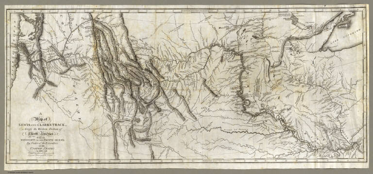
1st edition. Notwithstanding the title, Nicholas Biddle completed the text after Lewis's suicide. The map and the written account of the expedition changed American mapping of the northwest by giving the first accurate depiction of the relationship of the sources of the Missouri, the sources of the Columbia, and the Rocky Mountains. The map was copied by Samuel Lewis from William Clark's original drawing, and was engraved by Samuel Harrison. The title of the map is "A Map of Lewis and Clark's Track, Across the Western Portion of North America From the Mississippi to the Pacific Ocean ..." Maps are without color. In 2 volumes newly bound in full leather with the title "Lewis & Clark's Expedition ..." stamped in gilt on the spine.
Author
[Allen, Paul, Biddle, Nicholas, Clark, William, Lewis, Meriwether]
Full Title
A Map of Lewis and Clark's Track, Across the Western Portion of North America From the Mississippi to the Pacific Ocean; By Order of the Executive of the United States, in 1804, 5 & 6. Copied by Samuel Lewis from the Original Drawing of Wm. Clark. Smal. Harrison fct.
List No
3493.001
Note
Uncolored map showing topography and rivers in the region as well as towns, Indian villages, and population figures. Bound into the front of volume one.
Author
[Allen, Paul, Biddle, Nicholas, Clark, William, Lewis, Meriwether]
Full Title
Mouth of Columbia River.
List No
3493.006
Note
The mouth of the Columbia River and environs. Encampment, local village, and distances to nearby points shown on this uncolored map.
Author
[Bouchette, Joseph, Faden, William, 1750?-1836]
Full Title
(Composite of eastern sheets) To His Royal Highness George Augustus Frederick ... This Topographical map of the Province of Lower Canada, shewing its division into Districts, Counties, Seigniories, & Townships ... Is ... Most gratefully dedicated by ... Joseph Bouchette, His Majesty's Surveyor General of the Province & Lieutt. Colonel C.M. ... Published by W. Faden, Charing Cross, Augst. 12th. 1815. Engraved by J. Walker & Sons, 47 Bernard Street, Russell Square, London. J. Walker sculp. (with) Town of Three Rivers. (with) City of Quebec. (with) Town of Montreal ...
List No
4431.013
Note
Four easternmost sheets of 10-sheet engraved map. Includes views, and ornamental cartouche. Relief shown by hachures; depths by soundings. Shows buildings in cities.
Author
Carrigain, Philip
Full Title
New Hampshire. New Hampshire By Recent Survey made under the Supreme Authority And Published According To Law by Philip Carrigain, Counselor at Law And Late Secretary of the State. To his Excellency John Taylor Gilman Esq. ... by ... Philip Carrigain, Concord 1816. J.J. Barralet del. W. Harrison Scr. Philada. Entered ... 14th day of October 1814 by Philip Carrigain ... New Hampshire. (inset) The States of the Union East of the Hudson With the adjacent British Colonies. (inset) The Middle Southern And Western Sections of the United States with the Territories.
List No
2303.000
Note
1st and only ed. Engraved by W. Harrison. J.J. Barralet drafted the map. It was copyrighted in 1814. It was Carrigain's only map of importance, yet it is a spectacular map. Edged in teal blue silk and hand painted with full color by county. Map is dissected into 36 sections and folds into marbled end sheets then into a new tan cloth folding case 28x22.5 with "New Hampshire P. Carrigain 1816" stamped in gilt on the spine.
Author
Melish, John
Full Title
Map of the United States with the contiguous British & Spanish Possessions Compiled from the latest & best Authorities By John Melish. Engraved by J. Vallance & H.S. Tanner. Entered ... 6th day of June 1816. Published by John Melish Philadelphia. (inset) West Indies.
List No
5168.001
Note
With insets of the West Indies and a Statistical Table. This map has the distinction of being the first large scale detailed map made in the U.S. that showed the entire country from the Atlantic to the Pacific. This copy is an early state of the first edition -this is Martin's third state of the first edition and Ristow's fourth state (Ristow discovered a town and trail added in Ohio - Adelphi - making for a sub state of Martin's third state). The first state was an incomplete proof copy, making this the second/third state of the completed copy. The differences between this and the first complete state are small: Mansfield, Wooster, and Adelphi (and a trail from Adelphi to Athens and Chillicothe) added in Ohio, and "Vevay or" added before "Swiss Vineyards" in southeastern Indiana. Martin and Ristow identify seven states of the 1816 edition. Melish published new editions in 1818 (five states), 1819 (two states), 1820 (eight states), 1822 (two states), and 1823 (one state) for a total of twenty five different issues. Notwithstanding the many issues, the map has become extremely rare. A book accompanied the map (though issued separately) titled "A Geographical Description of the United States..." (see our #2424). Outline color by state or territory. This copy is dissected into 40 sections, backed with linen, and edged in brown cloth. It folds with marbled end sheets into new blue cloth folding boards and slip case 24.5x16.5 with leather label on spine reading "Melish. Map Of The United States. 1816" in gold.
Author
Smith, Charles, fl. 1800-1822
Full Title
Comparative View Of The Heights Of The Principal Mountains &c. In The World. Western Hemisphere. Eastern Hemisphere. London, Published by C. Smith, Mapseller No. 172 Strand, Augt. 1st 1816. Gardner Sculpt.
List No
0909.000
Note
Shows the comparative heights of mountains in the Eastern and Western Hemispheres, as well as the comparative heights of important places. A list of Authorities is given to the left of the title, and an Explanation shows how the system of numbering mountains and places works. A former owner has added "6225....White Mountains, N.H." to the table. This chart may be one of the earliest of its genre; it is not listed in Wolter's "Heights of Mountains..." (he lists the Thomson 1817 similar chart as the first of this type). The British Museum lists this Smith as the first chart of this kind. Interestingly, Smith's chart does not show the Himalayan Mountains; Thomson adds the Himalayan Mountains to his chart with a note about the recent publication of data on their heights. With black top and bottom sticks, and green silk edging. Full hand painted color.
Author
Melish, John
Full Title
Map of Illinois Constructed from the Surveys in the General Land Office and other Documents By John Melish. Saml. Harrison, sct. Entered according to Act of Congress the 16th day of April 1818. Philadelphia. Published by John Melish. Improved to 1820.
List No
5537.000
Note
Melish, in his first edition of "A Geographical Description of the United States," (1816) wrote of his plans to publish a series of sheet maps on a uniform scale that would form an atlas of the United States. He reiterated this plan in the 2nd and 3rd editions of the "Geographical Description" and expanded upon it in "A Geographical Description of the World" in 1818. According to Ristow, this plan to publish the maps at the same scale was "a new and revolutionary idea that facilitated size comparisons." Indiana was the first to be published in 1817. Tennessee was published in 1817. The Illinois map followed in 1818, with an "improved" edition in 1819. No mention is made in any sources of this map, "improved to 1820." Alabama was completed in 1818, Mississippi in 1819, and Louisiana in 1820. Only these six maps were completed before Melish died in 1822. A copy of the 1818 Illinois map is held at the Library of Congress. The 1819 map is held at the Newberry Library and the National Archives. No copy of the 1820 edition has been mentioned in the references. The map is in outline color by county with township and survey lines shown.
Author
Melish, John
Full Title
A diagram of the United States shewing the bearings and distances of the principal places from Washington, and from each other, with a scale of time. Prepared for the Travellers directory by John Melish. (Philadelphia: Published by the Author. 1822)
List No
0501.002
Note
Distances in geographical miles. "The scale at bottom below the Scale of Longitude shows the time."
Author
Lucas, Fielding Jr.
Full Title
Illinois. B.T. Welch Sc. Drawn & Published by F. Lucas Jr. Baltimore.
List No
4584.068
Note
Full color by county.
Author
[Dey, J. Ogden, Vance, David H.]
Full Title
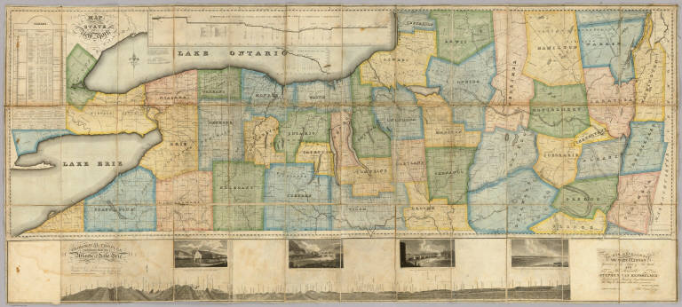
Map of the Western Part of the State Of New York. 1823. By D.H. Vance. Improved and enlarged to the east boundary of the State by J. Ogden Dey 1824. Engraved by Balch, Rawdon & Co. To His Excellency De Witt Clinton ... And ... Stephen Van Rensselaer ... This Map is Inscribed with their permission. By The Publisher John Ogden Dey. Albany January 1825. Copy Right Secured. (with four inset profiles).
List No
4999.001
Note
Vance published the upper and western part of this map in 1823 (see Streeter 3818). Dey enlarged it in 1824 and 1825 by adding an eastern portion, taking the state to its eastern boundary with New England, and also adding a lower section that includes a "Geological Profile Extending from the Atlantic to Lake Erie" (which shows the Erie Canal) and four views of the complete Erie Canal. On the main map is a profile of the western and middle sections of the Erie Canal and tables of statistics and geological remarks. The whole production is a celebration of the recently completed Erie Canal. Streeter calls the 1823 issue a "fine large scale colored map." Full color by county. Map has silk edging and is dissected into 36 sections. Folds with marbled paper end sheets, and lies loosely in quarter leather marbled paper covered boards 30x17 with leather ties; "Dey's Improved Map Of N. York" is stamped in gilt on the spine. Scarce.
Author
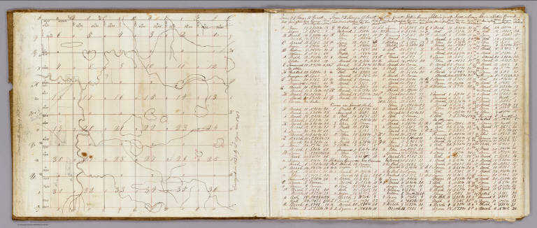
Lyon, Lucius, 1800-1851
Full Title
(Case to) (Michigan and Indiana Border Survey 1828-1835. Manuscript survey maps and notes)
List No
5125A
Note
The surveyor's copper canister or tube 8 cm. in diam. It is fitted with a buckle on the side and the remains of leather strap on a hinged lid which fed through the buckle; also 6 copper loops soldered to side of canister. The image also shows the roll of maps and notes contained therein.
Author
Lyon, Lucius, 1800-1851
Full Title
Town 7 South, Rang[e] 19 West. Surveyed in 1829 by L. Lyon, varr. 5035' E.
List No
5125.002
Note
Colored manuscript map. Pen-and-ink and pencil. Shows sections, quarter sections, smaller parcels, landowners, roads, hydrography, etc. Located in Berrien County, Michigan. Facing the map is a table of courses and distances measuring 42 x 37 cm.
Author
Finley, Anthony
Full Title
Illinois. Published by A. Finley Philada. Young & Delleker Sc.
List No
0285.027
Note
Full color by county.
Author
Loring, Josiah
Full Title
Loring's Terrestrial Globe containing all the Late Discoveries and Geographical Improvements, also the Tracks of the most celebrated Circumnavigators. Compiled from Smith's new English Globe, with additions and improvements by Annin & Smith. Boston: Josiah Loring, 136 Washington St. 1833.
List No
2899.000
Note
1st terrestrial globe by Loring. Loring's first globe was the 12" celestial of 1832. Loring's address is 136 Washington Street, Boston. Accompanied by the 12" celestial globe of 1833. Both the terrestrial and celestial were copied (with credit given) from C. Smith's English globes. Annin & Smith of Boston did the engraving. Loring was succeeded in business by Gilman Joslin who continued to produce globes under Loring's name until the 1850's (Warner). These two globes were commended by the Judges at the 1833 fair of the Massachusetts Charitable Mechanic Association (Warner). Four legged table model with horizon ring. Total height from bottom of base to top of the meridian is 17.5 inches.
Author
[Burr, David H., 1803-1875, Colton, J. H.]
Full Title
Texas, By David H. Burr. Published by J.H. Colton & Co. New-York. 1835 Engraved by S. Stiles & Co. N. York. Entered ... 1833, by J.H. Colton & Co. ... New York. (inset) Plan of the Port of Galveston, Made by order of the Mexican Government, By Alexander Thompson, Of the Mexican Navy, in 1828.
List No
5024.001
Note
This is the third edition of this scarce and important map of Texas. The first edition was issued in 1833 and the second edition in 1834. Streeter also lists an 1845 edition with the title changed to "The State of Texas." This copy was Streeter's copy with his notes on the inside front cover. The brown cloth covers 13.5x8 have "Burr's Map Of The State of Coha. & Texas Published By J.H. Colton & Co. New York" stamped in gilt. Full color. Streeter refers to this map as "the first large scale map of Texas... to show all of Texas to the Arkansas River" and states that "The Burr map, like the Austin Map, is one of the landmarks of Texas cartography..." The detail on the land grants is the best for its time. The 1833 issue shows a smaller Texas extending west to the 103rd meridian, whereas the 1834 and 1835 issues show a much expanded Texas extending west to about the 106th meridian and north to the Arkansas River. There is an inset map of Galveston Bay that Streeter refers to in his penciled notes on the inside cover as "1st detailed printed chart of Galveston Bay?" Above the inset map is a table of Distances. Yale has an 1835 edition that was issued earlier in the year than this copy - it does not show Milan's Grant in place of Beal's Grant and it does not list the four new towns that appear on our 1835 edition: Columbia, Electa, Mina and Augusta. Taliaferro 247 (illustrated) appears to be the same as Yale's copy.
Author
Berghaus, Heinrich
Full Title
Umrisse Der Pflanzengeographie. 5te Abtheilung: Pflanzengeographie, No. 1. Gezeichnet von Fr. Schelle. Gestochen von Joh. Carl Ausfeld. Gotha, J. Perthes, 1838.
List No
2515.048
Note
Map in full color shows the distribution of vegetation throughout the world. Five drawings above the map show the vegetation in numerous areas including the Andes, Himalayas and the Alps. Page includes a large key, statistical information and drawings of plants.
Author
Bradford, Thomas G.
Full Title
Illinois. Entered ... 1838, by T.G. Bradford ... Massachusetts. Engraved by G.W. Boynton.
List No
0089.020
Note
In full color.
Author
Bradford, Thomas G.
Full Title
Indiana. Entered ... 1838, by T.G. Bradford ... Massachusetts. Engraved by G.W. Boynton.
List No
0089.019
Note
In full color.
Author
[Burr, David H., 1803-1875, Greenleaf, Jeremiah]
Full Title
Illinois By David H. Burr New York. Engd. by Illman & Pilbrow.
List No
4850.046
Note
Full color by county.
Author
Winsor, Asa
Full Title
A plat of Serril Winsor Esqr. Farm situate lying and being in the town of Johnston and on both sides of the road that leades from Daniel Mathewson to widow Hannah Hawkins, and contains one hundred eighty three acres and forty four rods. Surveyed and platted from a scale of ten rods to an inch this 15th day of March, 1842. By Asa Winsor Surveyor.
List No
4015.000
Note
A very clear and attractive original survey of a Rhode Island farm. The farm is shown in Beers Atlas of Rhode Island, on page 19, Town of Johnston, Winsor District, marked S. Winsor. Pen-and-ink and watercolor. Oriented with north toward left. Shows buildings, courses and distances, etc.
Author
Society for the Diffusion of Useful Knowledge (Great Britain)
Full Title
Boston with Charlestown and Roxbury. Published under the superintendence of the Society for the Diffusion of Useful Knowledge. Engraved by B.R. Davies. London, published by Chapman & Hall, 186, Strand, August 1842. (1844)
List No
0890.166
Note
Engraved map. Relief shown by hachures. Hand col.
Author
Anderson, P.
Full Title
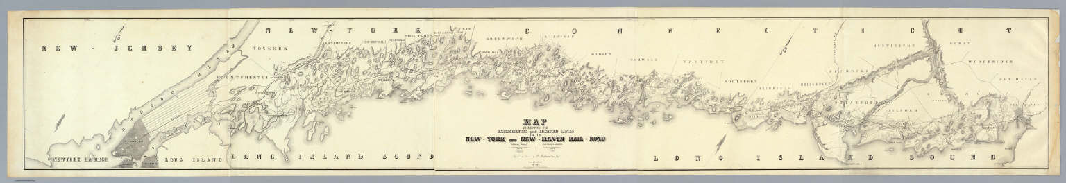
Map Exhibiting The Experimental and Located Lines for the New-York and New-Haven Rail-Road ... Projected and Drawn by P. Anderson Civil Engr. Scale 1 to 40,000. Febr. 1845. Snyder & Black Lithogrs. 87 Fulton St. New-York.
List No
4218.000
Note
Greatly detailed strip map over ten feet long showing the surveyed routes of the New York and New Haven Railroad. The line was opened in 1849. The map is unique for a railroad map in its huge size, large scale, elegance of drawing, and variety of information shown (houses, trails, rivers, turnpikes, lighthouses, harbors, hills, swamps, etc.).
Author
Fremont, J.C.
Full Title
Map Of An Exploring Expedition To The Rocky Mountains in the Year 1842, Oregon & North California In The Years 1843-44. By Brevet Capt. J. C. Fremont Of The Corps Of Topographical Engineers Under the orders of Col. J.J. Abert, Chief Of The Topographical Bureau. Lith. by E. Weber & Co. Baltimore, Md.
List No
1833.001
Note
House Issue; map in case. Lacks the astronomical observations that appear in the first issue by the Senate. The large map of the west is one of the most interesting and beautiful government maps of the 1840's. It filled in many of the gaps in cartographic knowledge of the west. Charles Preuss was the cartographer. Fremont and Preuss mapped only what they saw along their routes, leaving large areas blank. Map is without color. Book is bound with full leather with "Executive Documents 2d Sess. 28th Cong." on the spine in gold.
Author
[Breese, Samuel, 1802-1873, Morse, Sidney E. (Sidney Edwards), 1794-1871]
Full Title
Illinois. Entered ... 1844 by Sidney E. Morse and Samuel Breese. (New York: Published by Harper & Brothers, 1845)
List No
2301.020
Note
Col. wax engraved map. Prime meridians: Greenwich and Washington.
Author
[Fremont, J.C., Preuss, Charles]
Full Title
Topographical Map Of The Road From Missouri To Oregon, Commencing At The Mouth Of The Kansas In The Missouri River And Ending At The Mouth Of The Wallah Wallah In The Columbia. In VII Sections. Section IV. From the field notes and journal of Capt. J.C. Fremont, and from sketches and notes made on the ground by his assistant Charles Preuss. Compiled by Charles Preuss, 1846 By order of the Senate of the United States ... Lithogr. by E. Weber & Co. Baltimore ...
List No
2773.004
Note
This section of the map includes the Wind River Mountains and a discussion of the continental divide by Fremont. In his report Fremont states, "We mounted the barometer in the snow of the summit ... giving 13, 570 feet for the elevation above the Gulf of Mexico. Fields of snow lay far below us: boundless mountains stretched before us. A stillness the most profound, and a terrible solitude, forced themselves constantly on the mind as the great features of this place." This section traverses the war ground of the Indians, and so it is noted that guards and watches should be in place.
Author
[Fremont, J.C., Preuss, Charles]
Full Title
Topographical Map Of The Road From Missouri To Oregon, Commencing At The Mouth Of The Kansas In The Missouri River And Ending At The Mouth Of The Wallah Wallah In The Columbia. In VII Sections. Section VII. From the field notes and journal of Capt. J.C. Fremont, and from sketches and notes made on the ground by his assistant Charles Preuss. Compiled by Charles Preuss, 1846 By order of the Senate of the United States ... Lithogr. by E. Weber & Co. Baltimore ...
List No
2773.007
Note
This map contains the largest amount of written data. Copious notes are included from October 10th through October 25th. The last note tells about the first sighting of the Columbia River. Fremont notes that the distance from the mouth of the Kansas to "this place" is about 2,000 miles. They were greeted at Fort Wallah-Wallah by Mr. McKinley, the commander of the post, who received them "with great civility."
Author
Mitchell, Samuel Augustus
Full Title
A New Map Of Illinois With Its Proposed Canals Roads And Distances from place to place along the Stage & Steam Boat Routes (with) Lead Region. Published By S. Augustus Mitchell, N.E. corner of Market & 7th Street Philada., 1846. Entered ... 1846 by H.N. Burroughs ... Pennsylvania.
List No
0537.032
Note
In full color by county with steamboat route distances included.
Author
Fremont, J.C.
Full Title
Map Of Oregon And Upper California From the Surveys of John Charles Fremont And other Authorities. Drawn By Charles Preuss Under the Order of the Senate Of The United States, Washington City 1848. Lithy. by E. Weber & Co. Balto. (inset) Profile of the travelling route from the South Pass of the Rocky Mountains to the Bay of San Francisco.
List No
1857.001
Note
The map for the first time filled in the details of the Great Basin. Charles Preuss drew the map. A smaller version of the map appears in President Polk's Message of 1849 (see our copy). Report rebound with cloth covered boards and title on spine.
Author
Britton & Rey
Full Title
Map of San Francisco, Compiled from latest Surveys & containing all late extensions & Division of Wards. Published By Britton & Rey, San Francisco Cal.
List No
4333.000
Note
Letter sheet map showing the "Lately planket (sic) Streets" and the original shoreline. Streeter estimates the date by comparison with the Butler and Zakreski maps, which are earlier and later, respectively. With a vignette of an untitled building in the lower right corner. This copy was owned by the noted San Francisco collector Dr. Alexander Thomas Leonard, with his signature and notes on the verso of the board the map is mounted on. According to Sally Woodbridge the firm of of Page, Bacon & Co., which owned the building in the lower right corner was at the top of the banking heap in 1852; it was est. in 1849 as a branch of a St. Louis bank. In the financial panic of 1855 it suffered a disastrous run and was ruined along with many other banks.
Author
Colton, G.W.
Full Title
Illinois. (with) Vicinity Of Chicago. Published By J.H. Colton & Co. No. 172 William St. New York. Entered ... 1855 by J.H. Colton & Co. ... New York. No. 44.
List No
0149.049
Note
In full color by county.
Author
Colton, G.W.
Full Title
Indiana. Published By J.H. Colton & Co. No. 172 William St. New York. Entered ... 1855 by J.H. Colton & Co. ... New York. No. 41.
List No
0149.046
Note
In full color by county.
Author
Colton, G.W.
Full Title
Map Of Boston And Adjacent Cities. Published by J.H. Colton & Co. 172 William St. New York. Entered ... 1855 by J.H. Colton & Co. ... New York. No. 13.
List No
0149.021
Note
In full color. Areas in the Boston Harbor and the Mill Dam are sketched in with roads and open space.
Author
[Colton, J. H., New York And Erie Railway Company]
Full Title
Map of the New York and Erie Rail Road and its connections. The most direct route between New York and all Eastern & Western cities & towns. J.H. Colton & Co. Great broad gauge double track route ... Engraved, printed and mounted by J.H. Colton & Co., 172 William St., N. York. Entered ... 1856, by J.H. Colton ... New York.
List No
5296.000
Note
Certain states are shown in full color; railroad lines shown in red.
Author
[Garcia Cubas, Antonio, 1832-1912, Ramirez, Jose Fernando, 1804-1871]
Full Title
Cuadro historico-geroglifico de la peregrinacion de las tribus Aztecas que poblaron el Valle de Mexico. Num. I. Acompanado de algunas esplicaciones para su inteligencia, por D. Jose Fernando Ramirez, Conservador del Museo Nacional. Litog. de Iriarte y Ca., calle de Santa Clara no. 23. Munozguren litogo. Imprenta de Lara. Entegra 29a. (1858)
List No
4116.031
Note
Lithographed pictorial map. Surrounded by explanatory text. "Atlas mexicano, por Antonio Garcia y Cubas Cuadro I."
Author
[Colton, J. H., Norman, B.M., Persac, A.]
Full Title
Norman's Chart Of The Lower Mississippi River By A. Persac. Published by B.M. Norman, New Orleans, La. 1858. Entered ... 1858 by B.M. Norman ... Louisiana. Engraved, Printed & Mounted By J.H. Colton & Co. New York. (At top) From Natchez to New Orleans.
List No
2752.000
Note
Views; shows Plantations by type; very scarce. In full color; lacks original covers. See our reproduction copy issued by Pelican Press, originally in 1931, and printed by Rand McNally - this reproduction greatly alters the original. Ritzlin catalogue: "Persac was a well known surveyor and landscape painter... the map is quite scarce and normally in poor condition because most copies were used by river pilots to locate plantation landings. Few copies are known in contemporary boards. NUC lists only three copies ... however several copies are located in the south, including one which the Louisiana Supreme Court still uses in land ownership cases." Incredible detail, showing the Plantations on both sides of the river. Four engraved views. Engraved by J.H. Colton. Lacking boards, this copy has some tears at the folds with slight loss at some intersections, some light browning in two areas, but is overall a very good copy. Copies at LSU, Historic New Orleans Collection (504-523-4662). See Antiques Magazine, Nov. 1991 for Persac Article. Norman also published "Norman's New Orleans and Environs" with a map of the city, in 1845 (see our copy).
Author
Johnson, A.J.
Full Title
A Diagram Exhibiting the difference of time between the places shown & Washington. Ex. the figures on the Dials denote the Air-line distances from Washington. By Johnson & Browning. No. 84.
List No
2905.056
Note
Dials in color and in five rings around the center dial showing Washington at 12:00.
Author
Johnson, A.J.
Full Title
Johnson's Illinois By Johnson & Browning. No. 40.
List No
2905.025
Note
In full color by county.
Author
Bachmann, John
Full Title
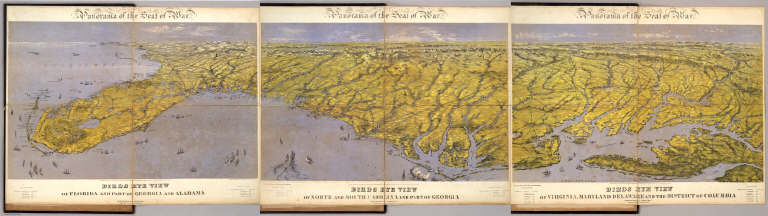
(Composite of) Panorama of the Seat of War. Birds eye view of Florida and part of Georgia and Alabama .. North and South Carolina and part of Georgia .. Virginia, Maryland, Delaware and the District of Columbia. John Bachmann, Publisher, 115 & 117 Nassau St., New York. Entered ... 1861 by John Bachmann ... New York. Drawn from Nature and Lith. by John Bachmann.
List No
5491.000
Note
Composite map image from three separate issues.
Author
Weyss, John E.
Full Title
Military Map showing the topographical features of the country adjacent to Harper's Ferry Va. including Maryland, Loudoun, and Bolivar Heights, and portions of South and Short Mountains, with the positions of the Defensive Works, also the Junction of the Potomac & Shenandoah Rivers, and their passage through the Blue Ridge. Surveyed from August 3d to Sept. 30th 1863 Under The Direction Of Capt. N. Michler, Corps of Engrs U.S. Army By Major John E. Weyss, Principal Assistant, Engineer Department, Army Of The Potomac ...
List No
3874.000
Note
Striking map of Harper's Ferry, illustrated in Stephenson. Weyss went on to make a second Harper's Ferry map that appeared (with fourteen other maps by Weyss) in 1867 in the Military Maps to Illustrate the Operations of the Armies of the Potomac and James. Stephenson lists the ms original as 699. Map is without color. Plate 42:1 in "Atlas to Accompany..."
Author
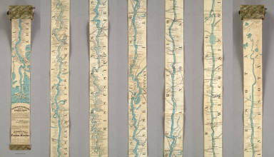
Coloney, Fairchild & Co.
Full Title
Coloney & Fairchild's Patent Ribbon Maps ... Ribbon Map Of The Father Of Waters. Geographical and Scenic Maps upon this plan of all the rivers, rail road routes, stage and coast lines in the country are in preparation.
List No
4995.000
Note
This is the most ambitious Coloney & Fairchild strip or ribbon map: it shows the Mississippi River from its delta to its source at Lake Itaska, a distance of 2600 miles. It is backed on linen and rolls into paper covered spool with a hand crank. This is the revised edition, with much additional material added on river towns by William Bowen, President of the Pilot's Association of St. Louis (this information comes from the promotion for this map printed on the Ribbon Map of New York City). No record of the first issue found, although a copy exists at the Minnesota Historical Society. The river is colored blue against a black and white background. Distances from New Orleans are printed on the river at intervals to the source. Karrow's listing is for a variant: the map printed in five strips on one sheet and folded into the 1866 edition of Edward's Gazetteer of the Mississippi River. Scarce.
Author
U.S. General Land Office
Full Title
Map of the United States and Territories, Showing the extent of Public Surveys and other details. Constructed From the Plats and official sources of the General Land Office, Under the direction of the Hon. Jos. S. Wilson, Commissioner, by Joseph Gorlinski, Draughtsman, 1867. Julius Bien, N.Y. Department of the Interior General Land Office Oct. 15th 1867. Jos. S. Wilson, Commissioner.
List No
1882.001
Note
Map accompanied the annual report of 1867. Map in full color by state. Map includes the township and range lines throughout the Midwest, south and west. Proposed surveys are indicated by dotted lines. An explanation at the lower left of the map includes symbols for gold, silver, copper, quicksilver, iron, tin, asphaltum, coal, and oil springs. Land offices are in bright red with the Surveyor Generals' Office in green. The report is bound with green linen and "Land Office Report. 1867. Abridgment" on the cover in gold.
Author
Joslin, Gilman
Full Title
Joslin's Six Inch Terrestrial Globe, Containing the Latest Discoveries. Boston. Gilman Joslin. Drawn and Engraved by W.B. Annin.
List No
4327.000
Note
The full color 6 inch globe is undated - the date is estimated from the presence of Alaska (1867). Oregon Territory is not shown (it is shown on the 1860 issue), and New Holland is removed from Australia. On a single turned wooden base with a total height of 11 inches. Very late issue of this globe.
Author
Haasis & Lubrecht
Full Title
The American Union Railroad Map Of The United States, British Possessions, West Indies, Mexico, And Central America. 1871. Published by Haasis & Lubrecht, 107 Liberty Street, New York. Smith & McDougal, Electrotypers, 82 Beekman Street, New York. (inset) Central America.
List No
3822.000
Note
This is a reworking of the Lubrecht and Rosa map "The American Continent" of 1864, and the first edition, first issue in a new format. Statistics at the top of the 1864 map are here replaced with a view "From the Atlantic to the Pacific Ocean" emphasizing the recently completed transcontinental railroad. Also, an elaborate title and view of a steam engine and train station have replaced the more subdued 1864 title. Population tables of the United States are added to the left and right sides of the map. The map itself has been updated to show political and some topographical changes of the ensuing seven years. Projected railroad lines are shown running everywhere in the west. The coloring is very bright, to match the decidedly optimistic (expansionist) flavor of the map. D.L. Guernsey published editions of 1871 and 1874 in Concord New Hampshire, with no major changes in the map. WH has an 1873 edition by Haasis and Lubrecht that adds text next to the population figures, more railroads, no changes in topography. Issued in a cover with a label in German from Wilhelm Lubrecht in Stuttgart, Germany, indicating it may have been sold to emigrants. Full color. Map has green paper edging, is dissected into 16 sections, and fold into a new gray cloth folding case 35x27 with "American Union Railroad Map Haasis & Lubrecht 1871" stamped in gilt on the spine.
Author
Wheeler, G.M.
Full Title
Skeleton Map Of the Territory of the United States west of the Mississippi River Exhibiting the Relations Existing Between Lines And Areas Of Explorations & Surveys Conducted under the auspices of the War Dept. Giving the area of the public domain lying west of the 100th Meridian Of Longitude With an index illustration of a series of Atlas Maps. Proposed to be constructed on a scale of 1 inch to 8 m. Engineer Department U.S. Army. U.S: Engineer Office, Washington D.C. Louis Nell Del. Am. Photo-lithographic Co. N.Y. (Osborne's Process) Prepared to accompany the "Preliminary & Progress Report" concerning the "Expedition of 1872 & 1873." Explorations And Surveys West Of The One-Hundredth Meridian.
List No
2738.001
Note
Outline map with lines of expeditions in red with surveyor and date given. Forts depicted with red flags. Areas of surveillance shown by hatches.
Author
Asher & Adams
Full Title
Asher & Adams' Illinois. Entered according to Act of Congress in the year 1874 by Asher & Adams ... at Washington. (New York, 1874)
List No
0041.021
Note
Hand col. engraved map. Shows townships, distances along railroads, etc. Prime meridians: Greenwich and Washington.
Author
[Andreas, A. T. (Alfred Theodore), 1839-1900, Ellsbury, Geo. H.]
Full Title
St. Paul, Minn. Geo. H. Ellsbury, del. Hoffman (lithographer). Chas. Shober & Co., Proprietors of Chicago Lith. Co. Entered, according to act of Congress, year 1874, by G.H. Ellsbury and Vernon Green ... (Published by A.T. Andreas, Lakeside Building, Chicago)
List No
3034.012
Note
Col. lithograph. Panoramic view.
Author
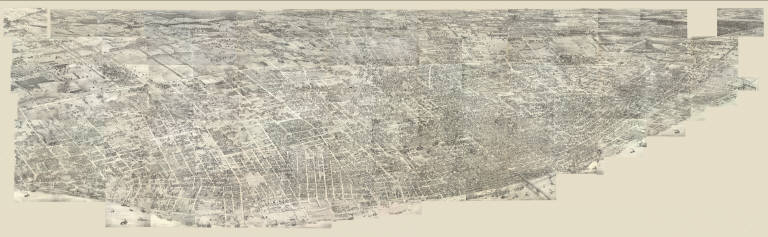
[Compton, Richard J., Dry, Camille N.]
Full Title
(Pictorial St. Louis) Composite (By C.N. Dry, 1876)
List No
4209.058
Note
Composite of 110 lithographed views.
Author
[Bishop, F. M., De Motte, B. C., Geological and Geographical Survey of the Territories (U.S.), Powell, John Wesley, 1834-1902, Thompson, A. H. (Almon Harris), 1839-1906]
Full Title
Green River from the Union Pacific Rail Road to the mouth of White River, 1873 (land cover). Department of the Interior. U.S. Geological and Geographical Survey of the Territories. Second Division. J.W. Powell, geologist in charge, A.H. Thompson, geographer, B.C. De Motte & F.M. Bishop, topographers. W.H. Graves del. Outlines engraved by S.J. Kubel. U.S. G. and G. Survey, 2d. Div. ... Geology of the Unita Mountains. (Julius Bien Lith.)
List No
2078.001
Note
Colored lithographed map. Relief shown by contours, spot heights and hachures. Shows irrigable lands, pine lands, cottonwood groves, and copper and silver region.
Author
[Geological and Geographical Survey of the Territories (U.S.), Gilbert, Grove Karl, 1843-1918, Powell, John Wesley, 1834-1902]
Full Title
Bird's-eye view of a part of the Uinta Uplift. Designed by G.K. Gilbert. U.S. G. and G. Survey, 2d. Div., J.W. Powell, geologist in charge. Geology of the Unita Mountains. (Julius Bien Lith.)
List No
2078.006
Note
Lithograph. Block diagram of an area measuring 40 by 50 miles. Vertical and horizontal scales (ca. 1:156,000)
Author
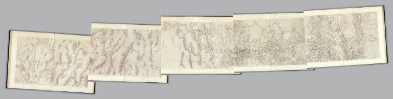
King, Clarence
Full Title
Green River Basin. Map II. (Topographical)
List No
0408.010
Note
Map in brown shaded relief. Map extends from Fortification Peak in Wyoming to Piedmont in Utah.
Author
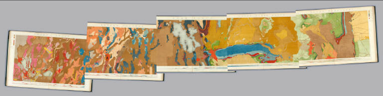
King, Clarence
Full Title
(Composite of) Geological Maps I-V, 40th Parallel Survey.
List No
0408.007
Note
Maps in full color with the legends on either side of the maps.
Author
King, Clarence
Full Title
(Composite of) Topographical Maps I-V, 40th Parallel Survey.
List No
0408.014
Note
Maps in brown shaded relief.
Author
[Union Atlas Co., Warner & Beers]
Full Title
Map of Edgar County. (Union Atlas Co., Warner & Beers, Proprietors. Lakeside Building Cor: of Clark & Adams Sts. Chicago. 1876. Entered ... 1876 by Warner & Beers ... Washington D.C.)
List No
1159.061
Note
Col. lithographed map. Shows townships and sections, landowners, acreages, railroads, schools, churches, farm houses, timbered areas, etc.
Author
[Union Atlas Co., Warner & Beers]
Full Title
(Portraits of) George S. Park, James Gaines, Omar H. Wright, Daniel Penoyer, Luther W. Lawrence, Granville Lowther, Capt. Wm. Haws, H.J. Swindler, Charles E. Fuller, Thomas McCord, John Haws, Joel Haws, Hiram P. White. (Union Atlas Co., Warner & Beers, Proprietors. Lakeside Building Cor: of Clark & Adams Sts. Chicago. 1876. Entered ... 1876 by Warner & Beers ... Washington D.C.)
List No
1159.059
Note
Thirteen lithographed portraits.
Author
[Union Atlas Co., Warner & Beers]
Full Title
Res. of James Gaines, Sec. 4, Ross T.P., Edgar Co., Ill. (Union Atlas Co., Warner & Beers, Proprietors. Lakeside Building Cor: of Clark & Adams Sts. Chicago. 1876. Entered ... 1876 by Warner & Beers ... Washington D.C.)
List No
1159.114
Note
Lithographed view with 3 insets: Bird's eye view of farm -- Tenant house -- Lake in the pasture.
Author
International & Great Northern Railroad
Full Title
Colonists' and emigrants' route to Texas. Rand, McNally & Co., Engr's, Chicago. (untitled inset map of the eastern half of the United States). (1878?)
List No
5050.001
Note
A birds eye view of Texas showing the lines of the International & Great Northern Railroad. With the stamp of Henry H. Hannan, Swan Creek, Ohio. Includes 5 drawings: Pictures of productions on the International & Great Northern Railroad.
Author
U.S. General Land Office
Full Title
Department Of The Interior General Land Office J.A. Williamson, Commissioner. State of Indiana. 1878. Compiled from the official Records of the General Land Office and other sources by C. Roeser, Principal Draughtsman G.L.O. Photo lith & print by Julius Bien 16 & 18 Park Place N.Y.
List No
5456.000
Note
Printed outline color.
Author
U.S. General Land Office
Full Title
Department Of The Interior General Land Office J.A. Williamson, Commissioner. Territory Of Dakota. 1879. Compiled from the official Records of the General Land Office and other sources by C. Roeser, Principal Draughtsman G.L.O. Photo lith & print by Julius Bien 16 & 18 Park Place N.Y.
List No
4645.000
Note
Good detail on the Black Hills. Printed color.
Author
[California. Office of State Engineer, Hall, Wm. Ham. (William Hammond)]
Full Title
Los Angeles & San Bernardino topography. Wm. H. Hall, State Engineer, Sacramento. (circa 1880)
List No
3451.000
Note
Beautiful hand drawn map of the Los Angles-San Bernardino Basin. Pen-and-ink and pencil. Relief shown by hachures. It appears to be a base map on a scale of two miles to an inch, probably preliminary (several of Hall's notations on the edges indicate corrections needed to the topography) and earlier than the 1888 Report titled "Irrigation in California" that had 15 maps that may have been derived from this map. It may also have served as the base for "Drainage area map to accompany report on irrigation and water supply in California" by Wm. Ham. Hall, State Engineer. (188-?). Hall was a famous engineer who was the first state engineer and was responsible for many of the early state water projects (see California Water Atlas). This map does not have any names drawn in except for a few towns, rivers, or railroads lightly penciled in. All the land divisions and city plats are indicated, with mountains, rivers, railroads, roads, arroyos and shorelines shown. Hall also published four maps of the San Joaquin Valley in 1886 (see WH's copy) separately (see Calfornia Water Atlas p.26). "VI." Title and cartographer from verso. "14" on verso.
Author
Hayden, F.V.
Full Title
Triangulation Map of Colorado. By J.T. Gardner and A.D. Wilson. Department of the Interior, U.S. Geological and Geographical Survey of the Territories, F.V. Hayden, U.S. Geologist in Charge. Sheet I.
List No
4576.001
Note
Map without color. Map shows lines radiating from the many spots used for triangulation measurements. Railroad lines are also shown.
|