Author
Burr, David H., 1803-1875
Full Title
(Contents to) A New Universal Atlas; Comprising Separate Maps Of all the Principal Empires, Kingdoms & States Throughout the World: and forming a distinct Atlas Of The United States. Carefully Compiled from the best Authorities Extant by David H. Burr. Published by D.S. Stone, N. York. Printed by Cammeyer & Clark, N.Y.
List No
4628C
Author
Burr, David H., 1803-1875
Full Title
Eastern Hemisphere. Entered ... 1834 by Illman & Pilbrow ... New York. Engrd. & Printd. by Illman & Pilbrow.
List No
4628.001
Note
In full color by region.
Author
Burr, David H., 1803-1875
Full Title
Western Hemisphere. Entered ... 1833 by Illman & Pilbrow ... New York.
List No
4628.002
Note
In full color by region.
Author
Burr, David H., 1803-1875
Full Title
Northern Hemisphere. Illman & Pilbrow Scupt. Entered ... 1833 by Illman & Pilbrow ... New York.
List No
4628.003
Note
In full color by region.
Author
Burr, David H., 1803-1875
Full Title
Southern Hemisphere. Engd. & Printed by Illman & Pilbrow. Entered ... by Illman & Pilbrow ... New York.
List No
4628.004
Note
In full color by region.
Author
Burr, David H., 1803-1875
Full Title
Europe. Entered ... 1834 by Thos. Illman ... New York.
List No
4628.005
Note
In full color by country.
Author
Burr, David H., 1803-1875
Full Title
British Islands. Drawn & Published by David H. Burr New-York. Entered ... Feby. 17th in the year 1832 by David H. Burr .. New York.
List No
4628.006
Note
In full color by country.
Author
Burr, David H., 1803-1875
Full Title
Scotland. (with) two inset maps Shetland Isles and Orkney Isles. Engd. & Printed by Illman & Pilbrow. Entered ... 1834, by Illman & Pilbrow ... New York.
List No
4628.007
Note
In full color by county.
Author
Burr, David H., 1803-1875
Full Title
Spain & Portugal. Entered ... 1834, by Thos. Illman ... New York.
List No
4628.008
Note
In full color by region.
Author
Burr, David H., 1803-1875
Full Title
France In Departments. By David. H. Burr, New-York. Entered ... 1832 by David H. Burr ... New York.
List No
4628.009
Note
In full color by Department. Includes list of numbered Departments.
Author
Burr, David H., 1803-1875
Full Title
Belgium And Holland. Entered ... Nov. 11th in the year 1831 by David H. Burr ... New York.
List No
4628.010
Note
In full color by country.
Author
Burr, David H., 1803-1875
Full Title
Germany. Entered ... 1834 by Thos. Illman ... New York.
List No
4628.011
Note
In full color by region. Reference to the States of the Germanic Confederation included.
Author
Burr, David H., 1803-1875
Full Title
Switzerland. Entered ... 1834 by Thos. Illman ... New York.
List No
4628.012
Note
In full color by canton.
Author
Burr, David H., 1803-1875
Full Title
Southern Part of Italy. Lettered by G.W. Teubuer. Entered ... 1835 by Thos. Illman ... New York.
List No
4628.013
Note
In full color by region.
Author
Burr, David H., 1803-1875
Full Title
Empire Of Austria. Entered ... 1835 by Thomas Illman ... New York.
List No
4628.014
Note
In full color by region.
Author
Burr, David H., 1803-1875
Full Title
Turkey in Europe. Entered ... 1835 by Thomas Illman ... New York.
List No
4628.015
Note
In full color by region.
Author
Burr, David H., 1803-1875
Full Title
Greece. Entered ... 1835 by Thomas Illman ... New York.
List No
4628.016
Note
In full color by region.
Author
Burr, David H., 1803-1875
Full Title
Prussian States. Entered ... 1835 by Thomas Illman ... New York.
List No
4628.017
Note
In full color by region.
Author
Burr, David H., 1803-1875
Full Title
Russian Empire. (with) Continuation of Kamtchatka. Entered ... 1834 by Thos. Illman ... New York.
List No
4628.018
Note
In full color.
Author
Burr, David H., 1803-1875
Full Title
Russian In Europe. Entered ... 1834 by Thos. Illman ... New York.
List No
4628.019
Note
In full color.
Author
Burr, David H., 1803-1875
Full Title
Denmark Sweden & Norway. Illman & Pilbrow Sculp. Entered ... 1833 by Illman & Pilbrow ... New York.
List No
4628.020
Note
In full color by country.
Author
Burr, David H., 1803-1875
Full Title
Asia. Entered ... 1835 by Thomas Illman ... New York.
List No
4628.021
Note
In full color by region.
Author
Burr, David H., 1803-1875
Full Title
Palestine or the Holy Land, Or the Land of Canaan. New York, Drawn & Published by David H. Burr. (with) Jerusalem. Entered ... 1832 by David H. Burr ... New York.
List No
4628.022
Note
In full color by region. History of the region's names listed. Religious and battle sites noted.
Author
Burr, David H., 1803-1875
Full Title
Chinese Empire And Japan. Entered ... 1835 by Thomas Illman ... New York.
List No
4628.023
Note
In full color by region.
Author
Burr, David H., 1803-1875
Full Title
Hindostan. Entered ... 1835 by Thomas Illman ... New York.
List No
4628.024
Note
In full color.
Author
Burr, David H., 1803-1875
Full Title
East India Isles. Entered ... 1835 by Thomas Illman ... New York.
List No
4628.025
Note
In full color.
Author
Burr, David H., 1803-1875
Full Title
New Holland And New Zealand. Entered ... 1834, by Illman & Pilbrow ... New York.
List No
4628.026
Note
In full color.
Author
Burr, David H., 1803-1875
Full Title
Africa. Entered ... 1834 by Thomas Illman ... New York.
List No
4628.027
Note
In full color.
Author
Burr, David H., 1803-1875
Full Title
Egypt. Engraved & Printed by Illman & Pilbrow. Entered ... 1834, by Illman & Pilbrow ... New York.
List No
4628.028
Note
In full color.
Author
Burr, David H., 1803-1875
Full Title
North America. Engraved & Printed by Illman & Pilbrow. Entered ... 1834 by Illman & Pilbrow ... N. York.
List No
4628.029
Note
In full color by region.
Author
Burr, David H., 1803-1875
Full Title
Lower Canada. Engraved & Printed by Illman & Pilbrow. Entered ... 1834, by Illman & Pilbrow ... New York.
List No
4628.030
Note
In full color by region.
Author
Burr, David H., 1803-1875
Full Title
Upper Canada. Entered ... 1833, by Illman & Pilbrow ... New York.
List No
4628.031
Note
In full color by region.
Author
Burr, David H., 1803-1875
Full Title
Newfoundland Nova Scotia And New Brunswick. Illman & Pilbrow Sculpt. Entered ... 1833, by Illman & Pilbrow ... New York.
List No
4628.032
Note
In full color by region.
Author
Burr, David H., 1803-1875
Full Title
United States. By David H. Burr. New-York. (with) Southern Part of Florida. Entered ... 1833 by Illman & Pilbrow ... New York.
List No
4628.033
Note
In full color by state.
Author
Burr, David H., 1803-1875
Full Title
Maine. Entered ... 1835 By Thomas Illman ... New-York.
List No
4628.034
Note
In full color by county.
Author
Burr, David H., 1803-1875
Full Title
Vermont And New Hampshire. Entered ... 1835 by Thomas Illman ... New-York.
List No
4628.035
Note
In full color by county.
Author
Burr, David H., 1803-1875
Full Title
New York. Drawn & Published by David H. Burr. New-York. (with) inset map of Long Island. Entered ... 1832 by David H. Burr ... New York.
List No
4628.036
Note
In full color by county.
Author
Burr, David H., 1803-1875
Full Title
Map of the Country Twenty Five Miles Round The City Of New-York. Entered ... Novr. 11th in the year 1835 by Thomas Illman ... New York.
List No
4628.037
Note
In full color by county.
Author
Burr, David H., 1803-1875
Full Title
Massachusetts. Rhode Island. And Connecticut. Entered ... Febr. 17th in the year 1835 by Thomas Illman ... New York.
List No
4628.038
Note
In full color by county.
Author
Burr, David H., 1803-1875
Full Title
Pennsylvania By David H. Burr New York. Entered ... 1834 by Illman & Pilbrow ... New York.
List No
4628.039
Note
In full color by county.
Author
Burr, David H., 1803-1875
Full Title
New-Jersey. Entered ... 1835 by Thos. Illman ... New York.
List No
4628.040
Note
In full color by county.
Author
Burr, David H., 1803-1875
Full Title
Delaware And Mary-Land, By David H. Burr New-York. (with) The Western Part Of Mary-Land. Engd & Prind by Illman & Pilbrow. Entered ... 1833 by Illman & Pilbrow ... New-York.
List No
4628.041
Note
In full color by county.
Author
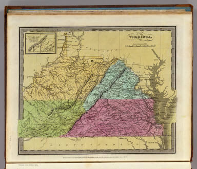
Burr, David H., 1803-1875
Full Title
Virginia. (with) The Western Part of Virginia. Entered ... 1834 by Thomas Illman ... New York.
List No
4628.042
Note
In full color by county.
Author
Burr, David H., 1803-1875
Full Title
Ohio. Entered ... Novr. 11th in the year 1831 by David H. Burr ... New York.
List No
4628.043
Note
In full color by county.
Author
Burr, David H., 1803-1875
Full Title
Michigan Drawn & Published by David H. Burr. New-York. Entered ... 1831 by David H. Burr ... New-York.
List No
4628.044
Note
In full color by county or region.
Author
Burr, David H., 1803-1875
Full Title
Indiana By David H. Burr New-York. Engd & Printed by Illman & Pilbrow. Entered ... 1833 by Illman & Pilbrow ... New York.
List No
4628.045
Note
In full color by county or region.
Author
Burr, David H., 1803-1875
Full Title
Illinois By David H. Burr New York. Engd by Illman & Pilbrow. Entered ... 1834 by Illman & Pilbrow ... New York.
List No
4628.046
Note
In full color by county or region.
Author
Burr, David H., 1803-1875
Full Title
Missouri. Entered ... 1834, by Thos. Illman ... New-York.
List No
4628.047
Note
In full color by county or region.
Author
Burr, David H., 1803-1875
Full Title
Oregon Territory. Illman & Pilbrow Sc. Entered ... 1833 by Illman & Pilbrow ... New-York.
List No
4628.048
Note
In full color by region.
Author
Burr, David H., 1803-1875
Full Title
Kentucky And Tennessee. Published ... 1834 by Thos. Illman ... New York.
List No
4628.049
Note
In full color by state.
Author
Burr, David H., 1803-1875
Full Title
Arkansas. Engraved & Printed by Thomas Illman. Entered ... 1835 by Thos. Illman ... New York.
List No
4628.050
Note
In full color by county.
Author
Burr, David H., 1803-1875
Full Title
North and South Carolina. W.F.H. Jr. Entered ... 1834 by Illman & Pilbrow ... New York.
List No
4628.051
Note
In full color by state.
Author
Burr, David H., 1803-1875
Full Title
Georgia. Entered ... 1834, by Thos. Illman ... New York.
List No
4628.052
Note
In full color by county.
Author
Burr, David H., 1803-1875
Full Title
Map of the State of Alabama. By David H. Burr. Entered ... 1834 by Illman & Pilbrow ... New York.
List No
4628.053
Note
In full color by county.
Author
Burr, David H., 1803-1875
Full Title
Mississippi. Entered ... 1835 by Thos. Illman ... New York.
List No
4628.054
Note
In full color by county or region.
Author
Burr, David H., 1803-1875
Full Title
Louisiana. Illman & Co. Sc. Entered ... 1834 by Thos. Illman ... New York.
List No
4628.055
Note
In full color by county or region.
Author
Burr, David H., 1803-1875
Full Title
Map of the Territory of Florida. W.F.H. & J.H. Sc. Entered ... 1834 by Illman & Pilbrow ... New York.
List No
4628.056
Note
In full color by county or region.
Author
Burr, David H., 1803-1875
Full Title
The United States Of Mexico. Drawn & Published by David H. Burr New York. (with) Guatemala or the United Provinces of Central America. Entered ... Feby. 16th 1832, by David H. Burr ... New York.
List No
4628.057
Note
In full color by state or region.
Author
Burr, David H., 1803-1875
Full Title
West Indies. Entered ... 1834 by Thomas Illman ... New York.
List No
4628.058
Note
In full color by region.
Author
Burr, David H., 1803-1875
Full Title
South America. Illman & Pilbrow Sculpt. Entered ... 1833 by Illman & Pilbrow ... New York.
List No
4628.059
Note
In full color by country or region.
Author
Burr, David H., 1803-1875
Full Title
Colombia. Entered ... 1834 by Illman & Pilbrow ... New York.
List No
4628.060
Note
In full color.
Author
Burr, David H., 1803-1875
Full Title
Peru and Bolivia. Engrd & Prd by Illman & Pilbrow. Entered ... 1833 by Illman & Pilbrow ... New York.
List No
4628.061
Note
In full color by country.
Author
Burr, David H., 1803-1875
Full Title
Brazil With Guiana & Paraguay. Entered ... 1834 by Thos. Illman ... New York.
List No
4628.062
Note
In full color by region.
Author
Burr, David H., 1803-1875
Full Title
United Provinces, Chili & Patagonia. Entered ... 1833 by Illman & Pilbrow ... New-York.
List No
4628.063
Note
In full color by region.
Author
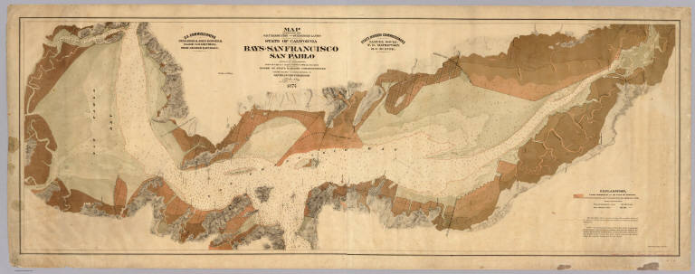
[Arnold, T. J. (Thomas Jefferson), d. 1878, California. Board of State Harbor Commissioners for San Francisco Harbor]
Full Title
Map exhibiting the salt marsh, tide and submerged lands disposed of by the State of California in and adjacent to the bays of San Francisco and San Pablo and now subject to reclamation. Prepared from maps of the U.S. Coast Survey & official records by order of the Board of State Harbor Commissioners for the United States Commissioners on San Francisco Harbor. By T.J. Arnold, engineer of the sea wall. 1874. U.S. Commissioners Rear Admiral John Rodgers, Major G.H. Mendell, Prof. George Davidson. State Harbor Commissioners Samuel Soule, T.D. Mathewson, D.C. McRuer. Britton Rey & Co. Lith. S.F.
List No
4469.000
Note
This map shows the shoreline property sold by the state to private parties and "now subject to reclamation" (i.e. ready to be filled). The Vogdes map is probably later. An unusual view of the bay, with east at the top; shows water depths. With black top and bottom rollers. With full printed color in subtle tan shades. Printed on 2 sheets. David Rumsey copy mounted as one sheet, backed with cloth.
Author
Carleton, Osgood
Full Title
(Covers to) Map Of Massachusetts Proper Compiled from Actual Surveys, made by Order of the General Court, and under the inspection of Agents of their appointment, By Osgood Carleton. Engraved by Joseph Callender and Samuel Hill, Boston, 1801. Vignette Drawn by G. Graham.
List No
2258A
Author
Carleton, Osgood
Full Title
Map Of Massachusetts Proper Compiled from Actual Surveys, made by Order of the General Court, and under the inspection of Agents of their appointment, By Osgood Carleton. Engraved by Joseph Callender and Samuel Hill, Boston, 1801. Vignette Drawn by G. Graham.
List No
2258.001
Note
Engraved by Joseph Callender and Samuel Hill. Second map of Massachusetts by Carleton (1st was 1798), reengraved from the plates of the first issue, and the first official state map (the first edition was rejected by the legislature). With outline and full color. Map is dissected into 32 sections and mounted on linen. Folds into original black cardboard slip case 21x16 with a red leather label on the spine reading "Map Of Mass." in gilt.
Author
Cary, John, ca. 1754-1835
Full Title
(Covers to) Chart of the world upon Mercator's projection drawn from the most recent geographical materials exhibiting the whole of the new discoveries with the tracks of the principal navigators accurately adjusted from the most exact astronomical observations. London; published By John Cary, No. 181 Strand June 1819.
List No
4639A
Note
A scarce map that is not listed in Fordham's Cary bibliography, nor in the British Museum list - the BM lists shows a later map (1827) with a different title. This is a finely detailed map in the best Cary style. The cartography follows closely his 18" globe of 1818 (see our copy) and may have been inspired by it - the scale is the same at the equator. The tracks of the various navigations of the period are shown with great precision. An interesting feature is the repetition of western Europe and Africa on both sides of the map. Full color. Map is dissected into 30 sections and folds into a dark olive green marbled board slip case 29x21 with label reading "World. Sold By C. Smith. Mapseller, 172 Strand, London." Relief shown pictorially.
Author
Cary, John, ca. 1754-1835
Full Title
Chart of the world upon Mercator's projection drawn from the most recent geographical materials exhibiting the whole of the new discoveries with the tracks of the principal navigators accurately adjusted from the most exact astronomical observations. London; published By John Cary, No. 181 Strand June 1819.
List No
4639.001
Note
A scarce map that is not listed in Fordham's Cary bibliography, nor in the British Museum list - the BM lists shows a later map (1827) with a different title. This is a finely detailed map in the best Cary style. The cartography follows closely his 18" globe of 1818 (see our copy) and may have been inspired by it - the scale is the same at the equator. The tracks of the various navigations of the period are shown with great precision. An interesting feature is the repetition of western Europe and Africa on both sides of the map. Full color. Map is dissected into 30 sections and folds into a dark olive green marbled board slip case 29x21 with label reading "World. Sold By C. Smith. Mapseller, 172 Strand, London." Relief shown pictorially.
Author
Chevalier, August
Full Title
The "Chevalier" Commercial, Pictorial and Tourist Map of San Francisco From Latest U.S. Gov. and Official Surveys. Designed-Engraved And Copyrighted By Aug. Chevalier, Lithographer Publisher, San Francisco ... copyrighted 1911 ...
List No
0140.000
Note
1st edition was 1903. A very beautiful map of San Francisco showing contour lines; all important buildings and public improvements are drawn in vignettes on the map. At the bottom of the map is the publisher's statement: "This Map is an Improved and Enlarged Edition of The Commercial Pictorial and Tourist Map of San Francisco Copyrighted Dec. 1903 by August Chevalier. Similar Maps For Other Cities in the U.S. Are Being Made." "The Exposition City 1915"
Author
Church, A. F. (Ambrose F.)
Full Title
Church's mineral map of Nova Scotia. Shewing by symbols the outcrop of the known coal seams, gold-bearing quartz-veins and ore-beds, containing mineral of economic value and importance. Published by A.F. Church & Co., Bedford, Halifax County. [Entered ... 1889, by Ambrose F. Church, of Bedford, Nova Scotia, at the Department of Agriculture.] Canada Bank Note Co. Lim., Photo-Lith., Montreal.
List No
4637.000
Note
Shows the height of coal and gold interest in Nova Scotia. A scarce map not in any listings. Extensive notes on the minerals of Nova Scotia. The printing process is color lithography, and very well done by the Canada Bank Note Co. of Montreal. Maps has pink cloth edging, marbled end sheets, and is dissected into 24 sections. Folds into a new dark blue cloth folding case 32x26.5 with "Mineral Map Of Nova Scotia A.F. Church 1889" stamped in gold on the spine. Full color.
Author
Coelho, Joao
Full Title
(Covers to) Mappa geral dos Estados Unidos do Brazil segundo os mais recentes trabalhos do Engenheiro Joao Coelho e edictado pela Livraria Allema de Ernst Nolte, Buenos Aires, 1891. Lit. e imp. Jose Ruland, Cuyo 361, Bs. As. (with) Plano parcial do Rio Grande do Sul e Santa Catharina. (with) Rio de Janeiro e parte de Minas Geraes e Sao Paulo.
List No
5467A
Note
Map dissected into 35 sections and mounted on linen. In printed color by state. Dissected into 35 pieces and mounted on linen, it folds to 22x14 and is affixed in a brown leather case with "Mapa Geral Dos Estados Unidos Do Brazil" in gold on the cover.
Author
Coelho, Joao
Full Title
Mappa geral dos Estados Unidos do Brazil segundo os mais recentes trabalhos do Engenheiro Joao Coelho e edictado pela Livraria Allema de Ernst Nolte, Buenos Aires, 1891. Lit. e imp. Jose Ruland, Cuyo 361, Bs. As. (with) Plano parcial do Rio Grande do Sul e Santa Catharina. (with) Rio de Janeiro e parte de Minas Geraes e Sao Paulo.
List No
5467.001
Note
Map dissected into 35 sections and mounted on linen. In printed color by state. Dissected into 35 pieces and mounted on linen, it folds to 22x14 and is affixed in a brown leather case with "Mapa Geral Dos Estados Unidos Do Brazil" in gold on the cover.
Author
Coello de Portugal y Quesada, Francisco, 1820-1898
Full Title
(Covers to) Isla de Puerto Rico por el Teniente Coronel Capitan de Ingenieros D. Francisco Coello, las notas estadisticas e historicas han sido escritas por D. Pascual Madoz. Madrid 1851. Posesiones de America. Atlas de Espana y sus posesiones de Ultramar. Diccionario geografico estadistico historico. Grabado en Madrid bajo la direccion de D. Juan Noquera. El contorno por Leclercq, la topografia por Debuissons y Estruch, la letra por Bacot. Las cartas que no tengan el sello de la empresa se consideraran falsificadas. (with) S. Juan de Puerto-Rico. (with) Contornos de Ponce. (with) Contornos de Mayaguez. (and other maps)
List No
5011A
Note
Ten maps and text on one large sheet. This is sheet [41] from the Atlas de Espana y sus posesiones de ultramar published in Madrid by Francisco Coello between 1848 and 1869. Only 45 of the planned 65 maps were completed. Each map was issued in folded form, with pocket map covers, as is the case here. The maps were intended to accompany the Diccionario geografico estadistico historico by Pascual Madoz. On this sheet are detailed maps of Puerto Rico, San Juan, and eight other maps of ports, neighboring islands and important geographical features. The text is historical and statistical. Folded into beautifully embossed brown leather covers 17.5x12 titled "Atlas de Espana y sus posesiones de ultramar por D. Francisco Coello Teniente coronel capitan de Ingenieros" in gilt. The map "Situacion de la Isla de Puerto-Rico," is hand col. Scales range from 1:20,000 -1:1,000,000. Prime meridian: Madrid.
Author
Coello de Portugal y Quesada, Francisco, 1820-1898
Full Title
Isla de Puerto Rico por el Teniente Coronel Capitan de Ingenieros D. Francisco Coello, las notas estadisticas e historicas han sido escritas por D. Pascual Madoz. Madrid 1851. Posesiones de America. Atlas de Espana y sus posesiones de Ultramar. Diccionario geografico estadistico historico. Grabado en Madrid bajo la direccion de D. Juan Noquera. El contorno por Leclercq, la topografia por Debuissons y Estruch, la letra por Bacot. Las cartas que no tengan el sello de la empresa se consideraran falsificadas. (with) S. Juan de Puerto-Rico. (with) Contornos de Ponce. (with) Contornos de Mayaguez. (and other maps)
List No
5011.001
Note
Ten maps and text on one large sheet. This is sheet [41] from the Atlas de Espana y sus posesiones de ultramar published in Madrid by Francisco Coello between 1848 and 1869. Only 45 of the planned 65 maps were completed. Each map was issued in folded form, with pocket map covers, as is the case here. The maps were intended to accompany the Diccionario geografico estadistico historico by Pascual Madoz. On this sheet are detailed maps of Puerto Rico, San Juan, and eight other maps of ports, neighboring islands and important geographical features. The text is historical and statistical. Folded into beautifully embossed brown leather covers 17.5x12 titled "Atlas de Espana y sus posesiones de ultramar por D. Francisco Coello Teniente coronel capitan de Ingenieros" in gilt. The map "Situacion de la Isla de Puerto-Rico," is hand col. Scales range from 1:20,000 -1:1,000,000. Prime meridian: Madrid.
Author
Colton, J. H.
Full Title
Map of North America from the latest authorities. Published by J.H. Colton. No. 86 Cedar St., New York. 1852. Drawn & Engraved by J.M. Atwood, New York. (with) Map of the Gold Region. California.
List No
4715.000
Note
See our #3507 and #170 for related maps. This map shows most of Alaska but not as far north as #3507. It is not clear where this map came from - it was folded to fit into a quarto sized book (not present here), and it may have been in the 1852 issue of the United States Register by John Disturnell, as #3507 was in the 1854 United States Register (see our 1861 U.S. Register by Disturnell with a smaller Colton Map). This map was also published in 1852 to accompany volume one of Richard Swainson Fisher's "The Book of The World", NY, J.H. Colton, two volumes, 8vo. It has the inset map of the gold regions, and the inset has been updated with many towns, etc. The main map has also been updated in the West, showing Utah, New Mexico, California, reduced Texas, etc. There is no inset map of South America as appears in the 1849 issue, and this map extends much further to the north to include most of Canada and about half of Alaska. All three of these maps were probably derived from Colton's Map of North America that is listed in his catalogues from 1851 to 1855 and is somewhat larger, we assume because of decorative borders. Strangely, that map is not found in any references. Without color. Includes view: Pyramid Lake, Upper California (i.e., Nevada)
Author
Cram, George Franklin
Full Title
(Covers to) New Commercial Atlas Of The United States and Territories: (Scale, 21 Miles To The Inch.) Showing All Railroads, Stations, Cities, Towns, Villages, Congressional Townships, Etc., Etc. A Complete Shippers' Guide. Drawn And Engraved From The Very Latest Government Surveys. Published By The Cram Atlas Company, New York And Chicago: Western Office, No. 66 Lake Street, Chicago. Entered ... 1875, by The Cram Atlas Company ... Washington, District of Columbia. Printed At The Lakeside Press, Clark And Adams Sts., Chicago.
List No
5370A
Author
Cram, George Franklin
Full Title
(Title Page to) New Commercial Atlas Of The United States and Territories: (Scale, 21 Miles To The Inch.) Showing All Railroads, Stations, Cities, Towns, Villages, Congressional Townships, Etc., Etc. A Complete Shippers' Guide. Drawn And Engraved From The Very Latest Government Surveys. Published By The Cram Atlas Company, New York And Chicago: Western Office, No. 66 Lake Street, Chicago. Entered ... 1875, by The Cram Atlas Company ... Washington, District of Columbia. Printed At The Lakeside Press, Clark And Adams Sts., Chicago.
List No
5370B
Note
The rarest and most attractive of Cram's atlases. The maps are large folio, with hand color, taken from the same plates as Cram's pocket maps of the same date (or vice versa). All maps are on the same scale, 19 miles to one inch. This issue is five years earlier than the earliest (1880) shown in U.S. Atlases. Later editions were 1878, 1880, 1881, and 1885 (which may be smaller). After 1885, Cram discontinued this atlas and concentrated on the mass produced "Unrivaled Family Atlas" and the "Standard American Railway Atlas." All maps with full hand painted color except for the Rand McNally foldout map which has printed color. Bound in half leather dark brown cloth covered boards embossed with title "The Cram Atlas Company's New Commercial Atlas. Index Page 2." in gold.
Author
Cram, George Franklin
Full Title
(Index Page to) New Commercial Atlas Of The United States and Territories: (Scale, 21 Miles To The Inch.) Showing All Railroads, Stations, Cities, Towns, Villages, Congressional Townships, Etc., Etc. A Complete Shippers' Guide. Drawn And Engraved From The Very Latest Government Surveys. Published By The Cram Atlas Company, New York And Chicago: Western Office, No. 66 Lake Street, Chicago. Entered ... 1875, by The Cram Atlas Company ... Washington, District of Columbia. Printed At The Lakeside Press, Clark And Adams Sts., Chicago.
List No
5370C
Author
Cram, George Franklin
Full Title
Cram's Rail Road & Township Map of Pa. Md. N.J. & Del. Published by Geo. F. Cram. Proprietor of the Western Map Depot. 66, Lake St. Chicago Ills. 1875.
List No
5370.001
Note
Map in full color by county. The railroad lines are clearly marked. (Note: The map has been rotated 90 degrees clockwise for readability.)
Author
Cram, George Franklin
Full Title
Cram's Rail Road & Township Map of New York. Published by Geo. F. Cram. Proprietor of the Western Map Depot. 66, Lake St. Chicago Ills. 1875.
List No
5370.002
Note
Map in full color by county. The railroad lines are clearly marked. (Note: The map has been rotated 90 degrees clockwise for readability.)
Author
Cram, George Franklin
Full Title
Cram's Rail Road & Township Map of Virginia & W.V. Published by Geo. F. Cram. Proprietor of the Western Map Depot. 66, Lake St. Chicago Ills. 1875.
List No
5370.003
Note
Map in full color by county. The railroad lines are clearly marked. (Note: The map has been rotated 90 degrees counterclockwise for readability.)
Author
Cram, George Franklin
Full Title
Cram's Rail Road & Township Map of New England. Published by Geo. F. Cram. Proprietor of the Western Map Depot. 66, Lake St. Chicago Ills. 1875.
List No
5370.004
Note
Map in full color by county. The railroad lines are clearly marked.
Author
Cram, George Franklin
Full Title
Cram's Rail Road & Township Map of North and South Carolina. Published by Geo. F. Cram. Proprietor of the Western Map Depot. 66, Lake St. Chicago Ills. 1875.
List No
5370.005
Note
Map in full color by county. The railroad lines are clearly marked. (Note: The map has been rotated 90 degrees clockwise for readability.)
Author
Cram, George Franklin
Full Title
Cram's Rail Road & Township Map of Florida. Published by Geo. F. Cram. Proprietor of the Western Map Depot. 66, Lake St. Chicago Ills. 1875.
List No
5370.006
Note
Map in full color by county. Inset map of southern Florida included. The railroad lines are clearly marked. (Note: The map has been rotated 90 degrees clockwise for readability.)
Author
Cram, George Franklin
Full Title
Cram's Rail Road & Township Map of Georgia. Published by Geo. F. Cram. Proprietor of the Western Map Depot. 66, Lake St. Chicago Ills. 1875.
List No
5370.007
Note
Map in full color by county. The railroad lines are clearly marked.
Author
Cram, George Franklin
Full Title
Cram's Rail Road & Township Map of Miss. & Alabama. Published by Geo. F. Cram. Proprietor of the Western Map Depot. 66, Lake St. Chicago Ills. 1875.
List No
5370.008
Note
Map in full color by county. The railroad lines are clearly marked. (Note: The map has been rotated 90 degrees clockwise for readability.)
Author
Cram, George Franklin
Full Title
Cram's Rail Road & Township Map of Kentucky and Tennessee. Published by Geo. F. Cram. Proprietor of the Western Map Depot. 66, Lake St. Chicago Ills. 1875.
List No
5370.009
Note
Map in full color by county. The railroad lines are clearly marked. (Note: The map has been rotated 90 degrees clockwise for readability.)
Author
Cram, George Franklin
Full Title
Cram's Rail Road & Township Map of Ohio. Published by Geo. F. Cram. Proprietor of the Western Map Depot. 66, Lake St. Chicago Ills. 1875.
List No
5370.010
Note
Map in full color by county. The railroad lines are clearly marked.
Author
Cram, George Franklin
Full Title
Cram's Rail Road & Township Map of Michigan. Published by Geo. F. Cram. Proprietor of the Western Map Depot. 66, Lake St. Chicago Ills. 1875.
List No
5370.011
Note
Map in full color by county. The railroad lines are clearly marked.
Author
Cram, George Franklin
Full Title
Cram's Rail Road & Township Map of Indiana. Published by Geo. F. Cram. Proprietor of the Western Map Depot. 66, Lake St. Chicago Ills. 1875.
List No
5370.012
Note
Map in full color by county. The railroad lines are clearly marked.
Author
Cram, George Franklin
Full Title
Cram's Rail Road & Township Map of Iowa. Published by Geo. F. Cram. Proprietor of the Western Map Depot. 66, Lake St. Chicago Ills. 1875.
List No
5370.013
Note
Map in full color by county. The railroad lines are clearly marked. (Note: The map has been rotated 90 degrees clockwise for readability.)
Author
Cram, George Franklin
Full Title
Cram's Rail Road & Township Map of Missouri. Published by Geo. F. Cram. Proprietor of the Western Map Depot. 66, Lake St. Chicago Ills. 1875.
List No
5370.014
Note
Map in full color by county. The railroad lines are clearly marked. (Note: The map has been rotated 90 degrees clockwise for readability.)
Author
Cram, George Franklin
Full Title
Cram's Rail Road & Township Map of Illinois. Published by Geo. F. Cram. Proprietor of the Western Map Depot. 66, Lake St. Chicago Ills. 1875.
List No
5370.015
Note
Map in full color by county. The railroad lines are clearly marked.
Author
Cram, George Franklin
Full Title
Cram's Rail Road & Township Map of Wisconsin. Published by Geo. F. Cram. Proprietor of the Western Map Depot. 66, Lake St. Chicago Ills. 1875.
List No
5370.016
Note
Map in full color by county. The railroad lines are clearly marked.
Author
Cram, George Franklin
Full Title
Cram's Rail Road & Township Map of Indian. Ty. Published by Geo. F. Cram. Proprietor of the Western Map Depot. 66, Lake St. Chicago Ills. 1875.
List No
5370.025
Note
Map in full color by county. Railroad lines clearly shown.
Author
Cram, George Franklin
Full Title
Cram's Rail Road & Township Map of New Mexico. Published by Geo. F. Cram. Proprietor of the Western Map Depot. 66, Lake St. Chicago Ills. 1875.
List No
5370.026
Note
Map in full color by county.
Author
Cram, George Franklin
Full Title
Cram's Rail Road & Township Map of Arizona. Published by Geo. F. Cram. Proprietor of the Western Map Depot. 66, Lake St. Chicago Ills. 1875.
List No
5370.027
Note
Map in full color by county.
Author
Cram, George Franklin
Full Title
Cram's Rail Road & Township Map of Colorado. Published by Geo. F. Cram. Proprietor of the Western Map Depot. 66, Lake St. Chicago Ills. 1875.
List No
5370.028
Note
Map in full color by county. Railroad lines clearly shown. (Note: The map has been rotated 90 degrees clockwise for readability.)
Author
Cram, George Franklin
Full Title
Cram's Rail Road & Township Map of Nevada. Published by Geo. F. Cram. Proprietor of the Western Map Depot. 66, Lake St. Chicago Ills. 1875.
List No
5370.029
Note
Map in full color by county. Railroad lines clearly shown.
Author
Cram, George Franklin
Full Title
Cram's Rail Road & Township Map of California. Published by Geo. F. Cram. Proprietor of the Western Map Depot. 66, Lake St. Chicago Ills. 1875.
List No
5370.030
Note
Map in full color by county. Railroad lines clearly shown. Inset of eastern California. (Note: The map has been rotated 90 degrees clockwise for readability.)
Author
Cram, George Franklin
Full Title
Cram's Rail Road & Township Map of Wyoming. Published by Geo. F. Cram. Proprietor of the Western Map Depot. 66, Lake St. Chicago Ills. 1875.
List No
5370.031
Note
Map in full color by county. Railroad lines clearly shown. (Note: The map has been rotated 90 degrees counterclockwise for readability.)
Author
Cram, George Franklin
Full Title
Cram's Rail Road & Township Map of Utah. Published by Geo. F. Cram. Proprietor of the Western Map Depot. 66, Lake St. Chicago Ills. 1875.
List No
5370.032
Note
Map in full color by county. Railroad lines clearly shown.
Author
Cram, George Franklin
Full Title
Cram's Rail Road & Township Map of Montana. Published by Geo. F. Cram. Proprietor of the Western Map Depot. 66, Lake St. Chicago Ills. 1875.
List No
5370.033
Note
Map in full color by county. Railroad lines clearly shown.
Author
Cram, George Franklin
Full Title
Cram's Rail Road & Township Map of Washington. Published by Geo. F. Cram. Proprietor of the Western Map Depot. 66, Lake St. Chicago Ills. 1875.
List No
5370.034
Note
Map in full color by county. Railroad lines clearly shown. (Note: The map has been rotated 90 degrees clockwise for readability.)
Author
Cram, George Franklin
Full Title
Cram's Rail Road & Township Map of Oregon. Published by Geo. F. Cram. Proprietor of the Western Map Depot. 66, Lake St. Chicago Ills. 1875.
List No
5370.035
Note
Map in full color by county. Railroad lines clearly shown. (Note: The map has been rotated 90 degrees counterclockwise for readability.)
Author
Cram, George Franklin
Full Title
New Railroad Map of the United States & Territories. Published by The Cram Atlas Co. Rand McNally & Co., Printers and Engravers, 79 and 81 Madison St., Chicago.
List No
5370.036
Note
Full color foldout map of the United States. Florida is truncated just below Ft. Clinch.
Author
[Cruz Cano y Olmedilla, Juan de la, d. 1790, Faden, William, 1750?-1836]
Full Title
Mapa Geografico de America Meridional, Dispuesto y Gravado por D. Juan de la Cruz Cano y Olmedilla, Geogfo. Pensdo. de S.M. Individuo de la Rl. Acadenia de Sn Fernando, y da la Sociedad Bascongada de los Amigos del Pais; teniendo presentes Varios Mapas y noticias originales con arreglo a Observaciones astronomicas, Ano de 1775 ... Londres, Publicaddo por Guillermo Faden, Geografo del Rey, y del Principo de Gales, Enero 1. de 1799.
List No
0220.000
Note
Reissue by Faden of 1775 original, 3rd edition. See Imago Mundi XX for a full discussion of this map. Faden's issue is an exact copy of the 3rd edition, omitting the borders and changing the title area. Smith, in his article in I.M., calls Cano's map the South American equivalent of Mitchell's map of the British Colonies of 1755. Outline hand color. Relief shown pictorially. Extensive notes. Map is in two sheets dissected into 18 sections each. Folds into a new cloth folding case 33x25 with "America Meridional Cruz Cano 1799" stamped in gilt on the spine.
Author
Dessiou, J. Foss
Full Title
A General Chart of the West Indies And Gulf Of Mexico, describing The Gulf and Windward Passages, Coast Of Florida, Louisiana And Mexico, Bay of Honduras and Musquito Shore; likewise the Coast Of The Spanish Main To The Mouths Of The Orinoco. Drawn from the Surveys taken by Mr. Geo. Gauld, and others, the New Spanish Charts, &c. and adjusted from recent Observations, By J. Foss Dessiou, Master of the Royal Navy. Approved by the Chart Committee of the Admiralty. London, Published by W. Faden ... Charing Cross, June 4, 1808. Engraved by J. Tyrer, Chapel St. Pentonville. (inset) Chart Of The Virgin Islands. (inset) Chart Of The Coast Of Biruquete, Panama & Veragua, From Point Solano To Point Burica.
List No
4754.000
Note
With two inset charts. This is a highly detailed general chart of the West Indies that is similar in scope and size to Arrowsmith's chart of the same area, but Dessiou's chart gives more detail to the coast lines, harbors, water depths, currents and less detail of the inland areas. We can find no specific reference to this wonderful chart, other than Tooley's Dictionary. Dessiou is listed in the National Maritime Museum Catalog as the author of a London edition of Le Petit Neptune Francais, also published by Faden. Scarce. Map is dissected into 40 sections, and mounted and edged with linen. Outline color. The map has a paste down label on the end sheet reading "Sold by Wm. Faden, Geographer to the King, Charing Cross". Folds into a new blue cloth folding case 32.5x21 with "Chart Of The West Indies J. Foss Dessiou 1808" stamped in gilt on the spine.
Author
Eddy, John H.
Full Title
The State of New York with part of the adjacent States. By John H. Eddy, Geographer, New York 1818. Engraved by Tanner, Vallance, Kearny & Co. Philadelphia. Printed by Saml. Maverick N. York. New York Published By James Eastburn & Co. At The Literary Rooms In Broadway.
List No
2622.000
Note
This map was published after Eddy's death (see biography of Eddy in American Monthly Magazine and Critical Review, May, 1818). Eddy was deaf, and died young at 35, on December 22, 1817. He also published a map of the county 30 miles around New York City (circular) in 1811 (see our copy), and a map of the western part of New York State for the canal commissioners in 1811. An extraordinary map maker about whom little has been known. He planned an American Atlas and a Map of the State of New Jersey, both abandoned after his death (perhaps Tanner's American Atlas was somehow related to Eddy's proposed Atlas). Tanner lists the three New York maps as sources for his New York Map in his American Atlas and has only the highest praise for Eddy. This New York State map is remarkable for its clarity of execution and detail. New York state counties and other states with outline color. Maps is dissected into 16 sheets, and lays in a new burgundy cloth folding case 29x25 with "State Of New York J.H. Eddy 1818" stamped in gilt on the spine.
Author
Eddy, William M.
Full Title
(covers to) Approved and declared to be the official map of the State of California by an act of the Legislature passed March 25th 1853. Compiled by W.M. Eddy State Surveyor General. Published for R.A. Eddy, Marysville, California by J.H. Colton, No. 86 Cedar St. New York 1854. Authorities --- (with inset:) San Francisco and Adjoining Bays. Engraved on stone by Schedler & Liebler, 129 William St. New York. Printed by D. McLellan, 26 Spruce St. N.Y. Entered according to act of Congress in the year 1853 by Wm. M. Eddy in the Clerk's Office of the District Court of the United States for the Northern District of California.
List No
5582A
Note
Lithograph, 49 3/4"x 38 1/2" plus floral border. Scale18 miles to an inch. Inset : 19 3/8"x 15 1/2", scale about 2 1/4 miles to an inch. Full color. Once folded, now flattened and backed with rice paper. Folder, 6 1/4"x 4 1/4" (15 x 12 cm.), rebacked, leather covered, blind stamped, title in gilt on front cover; verso front cover leaf of text advertising Colton's maps. In ink on leaf : Genl [name not decipherable] from Wm M Ed[dy ]. This matches signature on Eddy's Surveryor General's Report for 1852. According to Wheat, Eddy died in March, 1854. Wheat states that map was not yet ready in March 1854 but does not give reason. However, Eddy as Surveyor General states in his report dated Dec. 15, 1853 that he has received a few copies of the map and more were soon expected. My copy is signed by Eddy on verso of cover. Acquired from the Warren Heckrotte Collection, which is source of description and notes.
Author
Eddy, William M.
Full Title
Approved and declared to be the official map of the State of California by an act of the Legislature passed March 25th 1853. Compiled by W.M. Eddy State Surveyor General. Published for R.A. Eddy, Marysville, California by J.H. Colton, No. 86 Cedar St. New York 1854. Authorities --- (with inset:) San Francisco and Adjoining Bays. Engraved on stone by Schedler & Liebler, 129 William St. New York. Printed by D. McLellan, 26 Spruce St. N.Y. Entered according to act of Congress in the year 1853 by Wm. M. Eddy in the Clerk's Office of the District Court of the United States for the Northern District of California.
List No
5582.001
Note
Lithograph, 49 3/4"x 38 1/2" plus floral border. Scale18 miles to an inch. Inset : 19 3/8"x 15 1/2", scale about 2 1/4 miles to an inch. Full color. Once folded, now flattened and backed with rice paper. Folder, 6 1/4"x 4 1/4" (15 x 12 cm.), rebacked, leather covered, blind stamped, title in gilt on front cover; verso front cover leaf of text advertising Colton's maps. In ink on leaf : Genl [name not decipherable] from Wm M Ed[dy ]. This matches signature on Eddy's Surveryor General's Report for 1852. According to Wheat, Eddy died in March, 1854. Wheat states that map was not yet ready in March 1854 but does not give reason. However, Eddy as Surveyor General states in his report dated Dec. 15, 1853 that he has received a few copies of the map and more were soon expected. My copy is signed by Eddy on verso of cover. Acquired from the Warren Heckrotte Collection, which is the source of description and notes.
Author
Ferry, Julio Popper
Full Title
Plano del perimetro central, directorio comerical de la Ciudad de Mexico formado por Julio Popper Ferry. Al Senor Ministro De Gobernacion de los Estados Unidos Mexicanos, General Carlos Diez Gutierrez, testimonio de consideracion y respeto. En deposito: Litografia Debray Sucs., Mexico ... Propiedad Del Autor. Lit. Deray Sucs. Mexico. Ano 1o., 1ra. edicion.
List No
3302.000
Note
Shows businesses in the blocks just west of the Zocalo in Mexico City. Color litho. Folded into plain brown leather covers 18.5x12.
Author
Fullarton, A. & Co.
Full Title
(Covers to) The Royal Illustrated Atlas, Of Modern Geography With An Introductory Notice By Dr. N. Shaw, Secretary To The Royal Geographical Society &c. A. Fullarton And Co. London And Edinburgh. (title page only) W.B. Scott. W. Holl.
List No
3007A
Author
Fullarton, A. & Co.
Full Title
(Title Page to) The Royal Illustrated Atlas, Of Modern Geography With An Introductory Notice By Dr. N. Shaw, Secretary To The Royal Geographical Society &c. A. Fullarton And Co. London And Edinburgh. (title page only) W.B. Scott. W. Holl.
List No
3007B
Author
Fullarton, A. & Co.
Full Title
(Contents to) The Royal Illustrated Atlas, Of Modern Geography With An Introductory Notice By Dr. N. Shaw, Secretary To The Royal Geographical Society &c. A. Fullarton And Co. London And Edinburgh. (title page only) W.B. Scott. W. Holl.
List No
3007C
Note
1st edition 1864; published in 27 parts 1854-62. The date of 1872 is estimated by the Australia map; all the maps are undated and probably date throughout the period 1864 to 1872: the North America map shows Colorado and Russian America while the United States map has no Colorado. The World maps show Alaska. This is the last highly decorative atlas published in England. Even the maps without views or figures are beautifully engraved and colored with a mixture of printed color and hand color. Swanston, Petermann, Bartholomew, Macnab and Johnson engraved the maps. The introduction by Shaw among other things lists important general atlases published over a long period. He lists only one United States atlas, Mitchell's Universal Atlas of 1853! The maps bear a superficial resemblance to Keith Johnston's Royal Atlas. Fullarton frequently gives the sources for his maps - for the United States maps he gives Calvin Smith and Tanner as sources. The atlas is bound in half leather dark green cloth covered boards with "The Royal Illustrated Atlas." stamped in gilt on the cover; the spine reads "Royal Illustrated Atlas" in gold.
Author
Fullarton, A. & Co.
Full Title
(Contents to) The Royal Illustrated Atlas, Of Modern Geography With An Introductory Notice By Dr. N. Shaw, Secretary To The Royal Geographical Society &c. A. Fullarton And Co. London And Edinburgh. (title page only) W.B. Scott. W. Holl.
List No
3007D
Note
1st edition 1864; published in 27 parts 1854-62. The date of 1872 is estimated by the Australia map; all the maps are undated and probably date throughout the period 1864 to 1872: the North America map shows Colorado and Russian America while the United States map has no Colorado. The World maps show Alaska. This is the last highly decorative atlas published in England. Even the maps without views or figures are beautifully engraved and colored with a mixture of printed color and hand color. Swanston, Petermann, Bartholomew, Macnab and Johnson engraved the maps. The introduction by Shaw among other things lists important general atlases published over a long period. He lists only one United States atlas, Mitchell's Universal Atlas of 1853! The maps bear a superficial resemblance to Keith Johnston's Royal Atlas. Fullarton frequently gives the sources for his maps - for the United States maps he gives Calvin Smith and Tanner as sources. The atlas is bound in half leather dark green cloth covered boards with "The Royal Illustrated Atlas." stamped in gilt on the cover; the spine reads "Royal Illustrated Atlas" in gold.
Author
Fullarton, A. & Co.
Full Title
(Contents to) The Royal Illustrated Atlas, Of Modern Geography With An Introductory Notice By Dr. N. Shaw, Secretary To The Royal Geographical Society &c. A. Fullarton And Co. London And Edinburgh. (title page only) W.B. Scott. W. Holl.
List No
3007E
Note
1st edition 1864; published in 27 parts 1854-62. The date of 1872 is estimated by the Australia map; all the maps are undated and probably date throughout the period 1864 to 1872: the North America map shows Colorado and Russian America while the United States map has no Colorado. The World maps show Alaska. This is the last highly decorative atlas published in England. Even the maps without views or figures are beautifully engraved and colored with a mixture of printed color and hand color. Swanston, Petermann, Bartholomew, Macnab and Johnson engraved the maps. The introduction by Shaw among other things lists important general atlases published over a long period. He lists only one United States atlas, Mitchell's Universal Atlas of 1853! The maps bear a superficial resemblance to Keith Johnston's Royal Atlas. Fullarton frequently gives the sources for his maps - for the United States maps he gives Calvin Smith and Tanner as sources. The atlas is bound in half leather dark green cloth covered boards with "The Royal Illustrated Atlas." stamped in gilt on the cover; the spine reads "Royal Illustrated Atlas" in gold.
Author
Fullarton, A. & Co.
Full Title
(Contents to) The Royal Illustrated Atlas, Of Modern Geography With An Introductory Notice By Dr. N. Shaw, Secretary To The Royal Geographical Society &c. A. Fullarton And Co. London And Edinburgh. (title page only) W.B. Scott. W. Holl.
List No
3007F
Note
1st edition 1864; published in 27 parts 1854-62. The date of 1872 is estimated by the Australia map; all the maps are undated and probably date throughout the period 1864 to 1872: the North America map shows Colorado and Russian America while the United States map has no Colorado. The World maps show Alaska. This is the last highly decorative atlas published in England. Even the maps without views or figures are beautifully engraved and colored with a mixture of printed color and hand color. Swanston, Petermann, Bartholomew, Macnab and Johnson engraved the maps. The introduction by Shaw among other things lists important general atlases published over a long period. He lists only one United States atlas, Mitchell's Universal Atlas of 1853! The maps bear a superficial resemblance to Keith Johnston's Royal Atlas. Fullarton frequently gives the sources for his maps - for the United States maps he gives Calvin Smith and Tanner as sources. The atlas is bound in half leather dark green cloth covered boards with "The Royal Illustrated Atlas." stamped in gilt on the cover; the spine reads "Royal Illustrated Atlas" in gold.
Author
Fullarton, A. & Co.
Full Title
The World in Hemispheres with Comparative Views of the Heights of the Principal Mountains and Basins of the principal Rivers on the Globe. I. By G.H. Swanston. Published by A. Fullarton & Co. Edinburgh, London & Dublin.
List No
3007.001
Note
In full color. The hemispheres are surrounded by numerous lakes and basins around the world as well as the comparative views of the heights of the mountains.
Author
Fullarton, A. & Co.
Full Title
The World On Mercator's Projection. II. By G.H. Swanston, Edinr. A. Fullarton & Co. Edinburgh, London & Dublin. Engraved by G.H. Swanston, Edinburgh.
List No
3007.002
Note
In full color. Map includes three small hemispheres including a north polar projection, and the "Hemispheres on the Plane of the Horizon of London."
Author
Fullarton, A. & Co.
Full Title
Arctic Regions. The Arctic Regions, showing the North-West Passage as determined by Cap. R. McClure and other Arctic Voyagers. Compiled by J. Hugh Johnson, F.R.G.S. (with) Wellington Channel, Melville Island &c. from Admiralty Chart. III. Engraved by A. Fullarton & Co. A. Fullarton & Co. London and Edinburgh.
List No
3007.003
Note
In full color. Maps are surrounded by local scenes, wildlife, and depictions of local people.
Author
Fullarton, A. & Co.
Full Title
Europe by G.H. Swanston, Edinr. IV. Engd. G.H. Swanston Edinr. A. Fullarton & Co. Edinburgh, London & Dublin.
List No
3007.004
Note
In full color. Map has a red line which shows the extent of the North German Confederation.
Author
Fullarton, A. & Co.
Full Title
Central Europe with the Railways. V. By J. Bartholomew Jr. F.R.G.S. Engraved by J. Bartholomew, Edinr. A. Fullarton & Co. Edinburgh, London & Dublin.
List No
3007.005
Note
In full color. Railways in operation are shown in red, in progress in dotted red lines. Canals and steamboat lines also shown.
Author
Fullarton, A. & Co.
Full Title
Russian Empire according to Kiepert & others by G.H. Swanston Edinr. VI. Engraved by G.H. Swanston, Edinburgh. A. Fullarton & Co. Edinburgh, London & Dublin.
List No
3007.006
Note
In full color.
Author
Fullarton, A. & Co.
Full Title
Russian In Europe by G.H. Swanston Edinr. VII. Engraved by G.H. Swanston, Edinburgh. A. Fullarton & Co. Edinburgh, London & Dublin.
List No
3007.007
Note
In full color.
Author
Fullarton, A. & Co.
Full Title
Portions of the Russian Empire in Eastern & Western Asia. (with) The Aral Sea according to Khanikoff... (with) Kamtchatka according to A. Erman... (both) drawn by Augustus Petermann F.R.G.S. Engraved by G.H. Swanston. VIII. A. Fullarton & Co. London and Edinburgh.
List No
3007.008
Note
In full color. Maps surrounded by local scenes and drawings of the native people.
Author
Fullarton, A. & Co.
Full Title
Caucausus & Crimea with the Northern Portions of the Black & Caspian Seas, IX. (with) Crimea according to Huot & Demidoff. Drawn & Engraved by J. Bartholomew, Edinburgh. (with) The Caucasus according to Profr. Dr. Karl Koch, with additions from other Sources by Augustus Petermann, F.R.G.S. Engraved by G.H. Swanston. A. Fullarton & Co. London, Edinburgh & Dublin.
List No
3007.009
Note
Full color maps surrounded by depictions of people, animals, and local scenes.
Author
Fullarton, A. & Co.
Full Title
Sweden and Norway with Russian Finland by G.H. Swanston, Edinr. X. (with) Environs of Stockholm. Engd. by G.H. Swanston, Edinburgh. A. Fullarton & Co. Edinburgh, London & Dublin.
List No
3007.010
Note
In full color.
Author
Fullarton, A. & Co.
Full Title
Denmark with Schleswig & Holstein. XI. (with) five insets: Iceland, Bornholm, Virgin Islands, Faeroe Islands, and Santa Cruz. Engd. by G.H. Swanston, Edinburgh. A. Fullarton & Co. Edinburgh, London & Dublin.
List No
3007.011
Note
In full color. Colors correspond to the government based upon the treaty of 1864: The Kingdom of Denmark, the Duchies, and foreign possessions.
Author
Fullarton, A. & Co.
Full Title
Danish Islands in the North Atlantic Ocean. XII. (with) Iceland according to the Trigon Survey of Gunnlaugsson drawn by Augustus Petermann F.R.G.S. Engraved by G.H. Swanston. (with) Faroe Islands According to the Admiralty Surveys. Constructed & Engraved by G.H. Swanson, Edinr. A. Fullarton & Co. London, Edinburgh & Dublin.
List No
3007.012
Note
Maps in full color and surrounded by pictures of the local people, animals, and impressive sights. The Iceland map includes a list of mountains with their elevations.
Author
Fullarton, A. & Co.
Full Title
States of the Late Germanic Confederation compiled by J. Hugh Johnson, F.R.G.S. XIII. A. Fullarton & Co. Edinburgh, London & Dublin.
List No
3007.013
Note
In full color by departmental division. A key accompanies the map to explain the divisions.
Author
Fullarton, A. & Co.
Full Title
Northern and Central Germany. XIV. (with) The Northern & Central States of Germany. Drawn by Augustus Petermann, F.R.G.S. Engd. by J. Bartholomew, Edinr. (with) five inset maps: Hamburg, Coblente, Cologne, Dresden, and Leipsic. A. Fullarton & Co. London and Edinburgh.
List No
3007.014
Note
In full color. Each of the city maps has a legend referencing the letters shown.
Author
Fullarton, A. & Co.
Full Title
Southern Germany. XV. (with) Southern States of Germany comprising Bavaria, Wurtemburg, Baden, Nassau, Darmstadt, Coburg, &c. (with) five inset maps: Nuremberg, Munich, Mayence, State of Frankfort, and Frankfort. J. Bartholomew Sc. Edinr. A. Fullarton & Co. London, Edinburgh & Dublin.
List No
3007.015
Note
In full color. Each of the city maps has a legend referencing the letters shown.
Author
Fullarton, A. & Co.
Full Title
North German Confederation and Prussia according to Weiland, Stieler &c. Compiled by J. Hugh Johnson, F.R.G.S. XVI. (with) Principality of Hohenzollern.
List No
3007.016
Note
In full color.
Author
Fullarton, A. & Co.
Full Title
Austrian Empire by G.H. Swanston, Edinr. XVII. Engd by G.H. Swanston, Edinburgh. A. Fullarton & Co. Edinburgh, London & Dublin.
List No
3007.017
Note
In full color.
Author
Fullarton, A. & Co.
Full Title
Holland & Belgium by G.H. Swanston, Edinr. XVIII. Engd by G.H. Swanston, Edinburgh. A. Fullarton & Co. Edinburgh, London & Dublin.
List No
3007.018
Note
In full color. Note details the foreign possessions belonging to Holland.
Author
Fullarton, A. & Co.
Full Title
Sketch Map of the Dutch Possessions, in the Indian Archipelago. XIX. J. Bartholomew, F.R.G.S. Edinr.
List No
3007.019
Note
In full color.
Author
Fullarton, A. & Co.
Full Title
Principal Dutch Colonies in the Indian Seas. XX. (with) Java according to Van de Velde... (with) Borneo reduced from the large Map constructed for the Borneo Church Mission Institution... (both) drawn by Augustus Petermann, F.R.G.S. Engraved by G.H. Swanston. A. Fullarton & Co. London, Edinburgh & Dublin.
List No
3007.020
Note
In full color with maps surrounded by people, animals and places on the two islands. The Java map includes the elevation of mountains and "places."
Author
Fullarton, A. & Co.
Full Title
Dutch Possessions in South America and the West Indies. XXI. (with) seven inset maps: Saba; St. Martin; Curacao; On the North Coast of Venezuela, South America; Colonised Portion of Dutch Guayana or Surinam compiled from the Admiralty Surveys and the Dutch Government Map; Sketch Map shewing the Extent of the Colony; Plan of Paramaribo (Capital). A. Fullarton & Co. London, Edinburgh & Dublin.
List No
3007.021
Note
In full color. Maps split into two boxes, with four in one and three in the other. Maps surrounded by people, animals, and scenes from the possessions.
Author
Fullarton, A. & Co.
Full Title
Switzerland. XXII. Engraved by G.H. Swanston, Edinburgh. A. Fullarton & Co. Edinburgh, London & Dublin.
List No
3007.022
Note
In full color. A list of names and heights of principal mountains and passes included.
Author
Fullarton, A. & Co.
Full Title
Railway Map of the British Isles exhibiting all the railways & canals in England, Scotland & Ireland completed or in progress with their respective stations. By J. Bartholomew Junr. Edinr. F.R.G.S. XXIV. (with) six inset maps: Enlarged Section of the South Yorkshire and Lancashire Districts; Railways Around London; Birmingham; Manchester; Edinburgh; Glasgow. Engraved by J. Bartholomew, Edinr. A. Fullarton & Co. Edinburgh, London & Dublin.
List No
3007.024
Note
In full color. Railways shown in red; railways under construction shown with dotted red lines. Lists included of references to railways in England, Scotland, and Ireland.
Author
Fullarton, A. & Co.
Full Title
England & Wales by G.H. Swanston, Edinr. XXV. (with) Scilly Islands on the same scale. Engd. by G.H. Swanston, Edinr. A. Fullarton & Co. Edinburgh, London & Dublin.
List No
3007.025
Note
In full color by county. Note explains the coloring used on the map.
Author
Fullarton, A. & Co.
Full Title
Channel Islands, Scilly Islands, and Isle of Man. By J. Bartholomew, F.R.G.S. XXVa. Drawn & Engraved by J. Bartholomew Edinr. F.R.G.S. A. Fullarton & Co. Edinburgh, London & Dublin.
List No
3007.026
Note
In full color. The Channel Islands include: Alderney, the Casquets, Guernsey, Sercq, and Jersey.
Author
Fullarton, A. & Co.
Full Title
England and Wales, Cities, Ports & Harbours. 1st Metropolitan District &c. By J. Bartholomew, F.R.G.S. XXVI. Drawn & Engraved by J. Bartholomew, F.R.G.S. A. Fullarton & Co. London and Edinburgh.
List No
3007.027
Note
Three maps included. (1) London, Metropolitan Burghs and Southern & Eastern Environs. (2) Estuary of the Thames and the Medway. (3) Portland. All in color.
Author
Fullarton, A. & Co.
Full Title
Ports & Harbours on the East Coast of England. By J. Bartholomew, F.R.G.S. XXVII. A. Fullarton & Co. London and Edinburgh.
List No
3007.028
Note
Page includes 9 maps. (1) Mouth of the River Tyne with North & South Shields. (2) Sunderland. (3)Hartlepool and Mouth of the Tees. (4) Whitby. (5) Scarborough. (6) Goole. (7) Hull. (8) Great Grimsby. (9) Harwich. Maps in color.
Author
Fullarton, A. & Co.
Full Title
Ports & Harbours on the South East Coast of England. XXVIII. A. Fullarton & Co. London, Edinburgh & Dublin.
List No
3007.029
Note
Map page includes 12 maps. (1) Plymouth Sound. (1 (sic)) Ramsgate. (2) Plan of Portsmouth, Portsea, Spithead and Vicinity. By G.H. Swanston, Edinr. (2 (sic)) Margate. (3) Folkestone. (4) Dover. (5) Southampton. (6) Poole. (7) Exmouth. (8) Dartmouth. (9) Falmouth. (10) Penzance. In color.
Author
Fullarton, A. & Co.
Full Title
Ports & Harbours on the North West Coast of England. Drawn by J. Bartholomew Jr. F.R.G.S. Engraved by J. Bartholomew, Edinr. XXIX.
List No
3007.030
Note
Page includes 7 maps divided into two sets. Set 1: (1) Holyhead Harbour. (2) Fleetwood. (3) Silloth Harbour & Docks. Set 2: (1) Plan of the Town & Borough of Liverpool with Birkenhead, Tranmere, Seacombe, New Brighton &c. From the Ordnance & Other Surveys. (2) Environs of Liverpool and the Estuaries of the Mersey & Dee. (4 (sic)) Whitehaven. (5 (sic)) Lancaster. In color. Large map of Liverpool includes a list of references including street names and public buildings.
Author
Fullarton, A. & Co.
Full Title
Ports & Harbours on the South-West Coast of England. Drawn by J. Bartholomew Jr. F.R.G.S. Engraved by J. Bartholomew, Edinr. XXX. A. Fullarton & Co. London, Edinburgh & Dublin.
List No
3007.031
Note
Six maps numbered as two sets in full color. Set 1: (1) Milford Haven from the Admiralty and Ordnance Surveys. (with) Pembroke Dock. (2) Bristol Channel According to the Government Surveys by G.H. Swanston Edinburgh. (3) Bristol. Set 2: (1) Swansea. (2) Cardiff. (3) Newport Dock. (4) Fishguard Bay.
Author
Fullarton, A. & Co.
Full Title
Scotland by G.H. Swanston, Edinr. (with) The United County Of The Orkney And Shetland Islands. XXXI. Engd. by G.H. Swanston, Edinr. A. Fullarton & Co. Edinburgh, London & Dublin.
List No
3007.032
Note
In color with the railways in red. A "Reference to the Railways" is included.
Author
Fullarton, A. & Co.
Full Title
Ports And Harbours On The West Coast of Scotland. XXXII. A. Fullarton & Co. Edinburgh, London & Dublin.
List No
3007.033
Note
Ten maps in two sets and in color. Set 1: (1) Upper Estuary of the Clyde and Adjoining Country. Drawn from the Admiralty & other Surveys by J. Bartholomew Junr. Edinr. Engd. by G.H. Swanston, Junr. (with) Greenock. (2) City of Glasgow. Set 2: (1) Campbelltown Bay and Harbour. (2) Port Patrick. (3) Ayr. (4) Ardrossan. (5) Troon. (6) Irvine. (7) Rothesay. (8) Largs.
Author
Fullarton, A. & Co.
Full Title
Ports And Harbours On The East Coast of Scotland. XXXIII. Engraved by J. Bartholomew, Edinr. A. Fullarton & Co. Edinburgh, London & Dublin.
List No
3007.034
Note
Four maps of the area in full color. (1) Edinburgh with Leith & Granton. (2) Lower Estuary of the Forth and Adjacent Country. (3) Peterhead. (4) Aberdeen. All maps by J. Bartholomew, Edinr.
Author
Fullarton, A. & Co.
Full Title
Ireland According To The Government Survey By G.H. Swanston, Edinr. XXXIV. Engraved by G.H. Swanston, Edinr. A. Fullarton & Co. Edinburgh, London & Dublin.
List No
3007.035
Note
In full color.
Author
Fullarton, A. & Co.
Full Title
Irish Ports & Harbours. By J. Bartholomew, F.R.G.S. XXXV. A. Fullarton & Co. London and Edinburgh.
List No
3007.036
Note
Eight maps in color. (1) Environs of Dublin. (2) Belfast & Environs. (3) Londonderry & Lough Foyle. (4) Galway. (5) Sligo. (6) Wexford. (7) Kingstown. (8) Waterford Harbour & Environs. (9) Cork Harbour & Environs.
Author
Fullarton, A. & Co.
Full Title
British North America. Sheet I, East. Newfoundland, New Brunswick, Nova Scotia, Prince Edward Island &c. Compiled by J. Hugh Johnson, F.R.G.S. XXXVI. Engraved at Stanford's Geographical Establishment, 6 Charing Cross, London. A. Fullarton & Co. Edinburgh, London & Dublin.
List No
3007.037
Note
In full color.
Author
Fullarton, A. & Co.
Full Title
British North America. Sheet II, West. Canada with part of United States. Compiled by J. Hugh Johnson, F.R.G.S. XXXVII. Engraved at Stanford's Geographical Establishment, 6 Charing Cross, London. A. Fullarton & Co. Edinburgh, London & Dublin.
List No
3007.038
Note
In full color with the railways shown in red.
Author
Fullarton, A. & Co.
Full Title
British North America. Sheet III. Pacific Coast. British Columbia and Vancouver Island. By J. Bartholomew, F.R.G.S. XXXVIII. Drawn & Engraved by J. Bartholomew F.R.G.S. Edinr. A. Fullarton & Co. Edinburgh, London & Dublin.
List No
3007.039
Note
In outline color.
Author
Fullarton, A. & Co.
Full Title
British West Indian Possessions, Northern. XXXIX. (with) two maps: I. Bermuda or Somers' Islands. II. Island of Jamaica. Engraved by G.H. Swanston, Edinburgh. A. Fullarton & Co. London, Edinburgh & Dublin.
List No
3007.040
Note
In full color. Maps surrounded by views, and drawings of the people, animals, and flora of the islands.
Author
Fullarton, A. & Co.
Full Title
British Possessions on the North East Coast of South America. XL. (with) two maps: Island of Trinidad from Government and other Surveys. Drawn & Engd. by J. Bartholomew. Edinr. (and) British Guyana according to Sir Robert Schomburgk drawn by Augustus Petermann F.R.G.S. Engraved by G.H. Swanston. A. Fullarton & Co. London, Edinburgh & Dublin.
List No
3007.041
Note
In full color. Maps surrounded by views, and drawings of the people, animals, and flora of the islands.
Author
Fullarton, A. & Co.
Full Title
The British Possessions In The East Indies, With The Dependent States And Countries Adjacent. Compiled by J. Hugh Johnson, F.R.G.S. XLI. (with) Continuation of Map on same Scale. Engraved at Stanford's Geographical Establishment, 6 Charing Cross London. A. Fullarton & Co. Edinburgh, London & Dublin.
List No
3007.042
Note
In full color showing the British Possessions and the Native States.
Author
Fullarton, A. & Co.
Full Title
British Possessions In The Indian Seas. (with) I. British Settlements in the Malay Peninsula and Coast of Borneo. Compiled from the Admiralty and various other Surveys by J. Bartholomew Junr. Edinr. II. Island of Ceylon. By G.H. Swanston Edinr. XLII. A. Fullarton & Co. London, Edinburgh & Dublin.
List No
3007.043
Note
In full color. The British Settlement maps include: Malacca, Penang, Labouan, the Island of Singapore, the town and harbour of Singapore, and British possessions in the Malay Peninsula. Maps surrounded by drawings of the flora, fauna, and people of the possessions.
Author
Fullarton, A. & Co.
Full Title
Australia and New Zealand By Augustus Petermann. F.R.G.S. (with) I. The Prinicipal Portions of New South Wales and II. Victoria and the Adjoining Regions. XLIII. Engd. by G.H. Swanston Edinburgh. A. Fullarton & Co. Edinburgh, London & Dublin.
List No
3007.044
Note
Maps in full color. Counties in New South Wales and Victoria are labeled.
Author
Fullarton, A. & Co.
Full Title
France And Its Principal Foreign Possessions By G.H. Swanston. Edinr. (with) seven inset maps. XLIV. Engd. by G.H. Swanston Edinr. A. Fullarton & Co. Edinburgh, London & Dublin.
List No
3007.045
Note
In full color. Inset maps include: (1) Algeria (Africa), (2) Corse (Corsica), (3) Bourbon (Indian Ocean), (4) St. Marie Id., (5) French Guiana (S. America), (6) Gaudaloupe and Marie Galante (West Indies), (7) Martinique (West Indies).
Author
Fullarton, A. & Co.
Full Title
French Ports & Harbours, and Plan of Paris. By J. Bartholomew, F.R.G.S. XLV. (with) seven inset maps. A. Fullarton & Co. London and Edinburgh.
List No
3007.046
Note
In full color. Seven maps include: (1) Paris. and its surrounding fortifications by J. Bartholomew. F.R.G.S., (2) Boulogne, (3) Le Havre, (4) Cherbourg, (5) Brest, (6) Marseilles, (7) Toulon Harbour.
Author
Fullarton, A. & Co.
Full Title
Algeria (L'Algerie) Drawn by J. Hugh Johnson. F.R.G.S. Engraved at Stanford's Geographical Establishment, 6 Charing Cross London. (with) three inset maps. XLVI. A. Fullarton & Co. Edinburgh, London & Dublin.
List No
3007.047
Note
In partial color. Three inset maps include: 1. Algiers and Environs, 2. Constantine and Environs, 3. Oran and Environs.
Author
Fullarton, A. & Co.
Full Title
Kingdom of Italy. According to Keipert &c. (with) five inset maps. XLVII. Engd. by G.H. Swanston, Edinburgh. A. Fullarton & Co. Edinburgh, London & Dublin.
List No
3007.048
Note
In full color. Five inset maps include: (1) Sicily, (2) Strait of Messina, (3) Malta and its Dependencies, (4) Bay of Naples and its Vicinity, (5) Rome and the Adjoining Country.
Author
Fullarton, A. & Co.
Full Title
Spain & Portugal By G.H. Swanston, Edinr. (with) Balea'ric Islands. XLVIII. Engd. by G.H. Swanston, Edinburgh. A. Fullarton & Co. Edinburgh, London & Dublin.
List No
3007.049
Note
In outline color.
Author
Fullarton, A. & Co.
Full Title
Portuguese Islands in the Atlantic Ocean. (with) (I) Azores Or Western Isles Compiled from the Admiralty Surveys by J. Bartholomew Junr. Edinr. (II) Island Of Madeira By G.H. Swanston, Edinr. XLIX. A. Fullarton & Co. London, Edinburgh & Dublin.
List No
3007.050
Note
Azores maps include 12 inset maps: (1) General Sketch of the Group in their true positions, (2) San Miguel, (3) Terceira, (4) Pico and San Jorge (5) Fayal, (6) Corvo, (7) Sta. Maria, (8) Graciosa, (9) Flores, (10) Horta, (11) Ponta Delgada, (12) Angra in Terceira. Maps in color and surrounded by drawings of the land, flora, fauna, and people of the islands.
Author
Fullarton, A. & Co.
Full Title
Greece Chiefly According To The English Admiralty Surveys & Keipert. Drawn by Augustus Petermann. F.R.G.S. Engraved by G.H. Swanston. (with) The Northern Ionian Islands. L. A. Fullarton & Co. Edinburgh, London & Dublin.
List No
3007.051
Note
In full color.
Author
Fullarton, A. & Co.
Full Title
Turkish Empire (with) 1. Continuation of Map Part of Upper Egypt 2. Enlarged Plan of the Strait of Dardanelles 3. Enlarged Plan of the Bosporus. LI. A. Fullarton & Co. Edinburgh, London & Dublin.
List No
3007.052
Note
In full color.
Author
Fullarton, A. & Co.
Full Title
Turkey; Central Mediterranean Regions. (with) 1. The Grecian Archipelago according to the English Admiralty Survey (1828-1849) drawn by Augustus Petermann F.R.G.S. Engraved by G.H. Swanston. 2. Constantinople. According to the Survey of Dufour and Admiralty Charts. By G.H. Swanston, Edinr. LII. A. Fullarton & Co. London, Edinburgh & Dublin.
List No
3007.053
Note
Maps in outline color with drawing surrounding the maps in full color. Drawings are of the animals, plants, people, and famous sites of the region.
Author
Fullarton, A. & Co.
Full Title
Turkey in Asia (Biblical Regions) The Holy Land And Its Borders. Including Ancient Phoenicia, The Hauran, and Adjacent Districts; Showing Jewish, Roman & Modern Divisions And Topography. From numerous recent & authentic Sources By J. Hugh Johnson F.R.G.S. LIII. Drawn and Engraved at Stanford's Geographical Establishment, 6 Charing Cross, London. A. Fullarton & Co. Edinburgh, London & Dublin.
List No
3007.054
Note
A full color map of the Holy Land. The map includes a great deal of information about the governmental structure, names of the regions and places, and historical notes such as the location of saints' tombs, convents, and Roman ruins.
Author
Fullarton, A. & Co.
Full Title
North America. LIV. Engd. by G.H. Swanston Edinr. A Fullarton & Co. Edinburgh, London & Dublin.
List No
3007.055
Note
Map in full color. Note below title states "Including the most recent discoveries in the Arctic Seas and West Coast, from Government charts and report, United States survey &c."
Author
Fullarton, A. & Co.
Full Title
United States. North America. By G.H. Swanston Edinr. LV. Engd. by G.H. Swanston Edinburgh. A. Fullarton & Co. Edinburgh, London & Dublin.
List No
3007.056
Note
Map in full color. The United States is outlined in brown, with each individual state or territory marked by dotted red lines.
Author
Fullarton, A. & Co.
Full Title
United States North America According to Calvin, Smith & Tanner. By G.H. Swanston Edinr. The North Eastern States Comprising Maine, New Hampshire, Vermont, New York, Massachusetts, Rhode Id., Connecticut, New Jersey, Delaware, Pennsylvania, Maryland, Ohio, and part of Virginia & Michigan. LVI. Engraved by G.H. Swanston Edinburgh. A. Fullarton & Co. Edinburgh, London & Dublin.
List No
3007.057
Note
In full color by state.
Author
Fullarton, A. & Co.
Full Title
United States North America According to Calvin, Smith & Tanner. By G.H. Swanston Edinr. The North Central Section Comprising Michigan, Illinois, Wisconsin, Iowa, Indiana, Nebraska, Minnisota (sic), and part of Missouri & Kentucky. LVII. Engraved by G.H. Swanston Edinburgh. A. Fullarton & Co. Edinburgh, London & Dublin.
List No
3007.058
Note
In full color. Township lines are shown throughout the map.
Author
Fullarton, A. & Co.
Full Title
United States North America According to Calvin, Smith & Tanner. By G.H. Swanston Edinr. The South Eastern States Comprising Mississippi, Alabama, Tennessee, Georgia, Nth. & Sth. Carolina, and part of Florida, Virginia & Kentucky. LVIII. Engd. by G.H. Swanston Edinburgh. A. Fullarton & Co. Edinburgh, London & Dublin.
List No
3007.059
Note
In full color by state.
Author
Fullarton, A. & Co.
Full Title
United States North America According to Calvin, Smith & Tanner. By G.H. Swanston Edinr. The South Central Section Comprising Texas, Louisiana, Mississippi, Arkansas, Western Territory, and part of Missouri. LIX. Engraved by G.H. Swanston Edinburgh. A. Fullarton & Co. Edinburgh, London & Dublin.
List No
3007.060
Note
In full color.
Author
Fullarton, A. & Co.
Full Title
Northern Ports & Harbours in the United States. By J. Bartholomew, F.R.G.S. (with) six maps. LX. A. Fullarton & Co. London and Edinburgh.
List No
3007.061
Note
Maps in full color. Six maps include: (1) Portland Harbour. (2) Boston Harbour, and Vicinity. (3) Hudson River. (4) New York Harbour and Vicinity. (5) Philadelphia. (6) Baltimore.
Author
Fullarton, A. & Co.
Full Title
Southern Ports & Harbours in the United States. By J. Bartholomew, F.R.G.S. (with) eight maps. LXa. A. Fullarton & Co. London and Edinburgh.
List No
3007.062
Note
Maps in full color. Eight maps include: (1) Washington. (2) Beaufort Harbour. North Carolina. (3) Charleston Harbour. South Carolina. (4) Mobile Bay. (5) Pensacola Bay. Florida. (6) Key West Island. Florida. (7) Delta of the Mississippi & Environs of New Orleans. (8) Galveston Entrance. Texas.
Author
Fullarton, A. & Co.
Full Title
The West Indies. By G.H. Swanston, Edinr. (with) The Most Important Of The Lesser British Islands On An Enlarged Scale. LXI. Engd. by G.H. Swanston Edinburgh. A. Fullarton & Co. Edinburgh, London & Dublin.
List No
3007.063
Note
In full color. Inset maps include the Virgin Islands, Windward Islands, Leeward Islands, and the Bermudas.
Author
Fullarton, A. & Co.
Full Title
Central America, Namely The (Late) Confederated States of Central America; The Mexican States of Chiapa, Tabasco & Yucatan; and British Honduras. According to Squier, Keipert, &c. By John MacNab Esqr. F.R.G.S. LXII. Engraved by J. Bartholomew, Edinr. A. Fullarton & Co. Edinburgh, London & Dublin.
List No
3007.064
Note
In full color. Ruins are marked by name if known, "Ruins" if unknown and "R" if the ruins are extensive but isolated.
Author
Fullarton, A. & Co.
Full Title
South America. With the latest additions & rectifications of Pentland, Parish, Fitzroy, Herndon &c. LXIII. Engd. by G.H. Swanston, Edinr. A. Fullarton & Co. Edinburgh, London & Dublin.
List No
3007.065
Note
Map color coded to shown colonial status of each country.
Author
Fullarton, A. & Co.
Full Title
South American States. New Granada & Venezuela. LXIV. (with) Continuation of Map. Engraved by J. Bartholomew, Edinr. A. Fullarton & Co. Edinburgh, London & Dublin.
List No
3007.066
Note
In outline color by country.
Author
Fullarton, A. & Co.
Full Title
East Coast of South America. Brazil, Middle Provinces. LXV. (with) two maps. Engraved by J. Bartholomew, Edinr. A. Fullarton & Co. London & Edinburgh.
List No
3007.067
Note
In full color. Two maps include: 1. East Coast of Brazil; Bahia, Sergipe, Alagoas and part of Pernambuco (with inset continuation of the same map). 2. Province of Rio de Janeiro, Brazil. From the Map of H. Mahlmann. Drawn by G.H. Swanston. Maps surrounded by drawings of the local people, ports, and transportation.
Author
Fullarton, A. & Co.
Full Title
West Coast of South America Including Chili & Part of Bolivia & Peru. LXVI. (with) four maps. A. Fullarton & Co. London, Edinburgh & Dublin.
List No
3007.068
Note
Maps in full color. Map 1: Peru-Bolivian Tablelands; Chiefly according to Pentland, Parish, Fitzroy Meyen, Arrowsmith &c. &c. Constructed by Augustus Petermann, F.R.G.S. Engraved by G.H. Swanston. Maps 2-4: Chile according to Admiralty Surveys, United States Expn. by J. Bartholomew Junr. F.R.G.S. (North, central and south portions.) Maps surrounded by full color drawings of the people, animals, and landscape of the area.
Author
Fullarton, A. & Co.
Full Title
Asia by G.H. Swanston, Edinr. LXVII. Engd. by G.H. Swanston, Edinburgh. A. Fullarton & Co. Edinburgh, London & Dublin.
List No
3007.069
Note
In full color.
Author
Fullarton, A. & Co.
Full Title
China. By G.H. Swanston & J. Bartholomew. LXVIII. (with) Island of Chusan. (and) Estuary of the Canton River from Hong Kong to Canton. From the Admiralty Surveys. A. Fullarton & Co. Edinburgh, London & Dublin.
List No
3007.070
Note
In full color.
Author
Fullarton, A. & Co.
Full Title
Islands of Japan. (with) Japan, Mandshuria, (Showing the Course of the Amur River) The Kurile Isles &c. According to the British & Russian Admiralty Surveys, Krusenstern, Siebold &c. By J. Bartholomew Junr. Edinr (with) Port of Nagasaki, In the Island of Kiou-siou. LXIX. Engraved by J. Bartholomew, Edinr. A. Fullarton & Co. Edinburgh, London & Dublin.
List No
3007.071
Note
In full color. With drawings of local people, and the port of Simoneseke.
Author
Fullarton, A. & Co.
Full Title
Indian Archipelago Compiled From The Various Surveys of the British & Dutch Governments And Other Materials In Possession Of The Royal Geographical Society. By J. Bartholomew Junr. Edinr. LXX. Engraved by J. Bartholomew, Edinburgh. A. Fullarton & Co. Edinburgh, London & Dublin.
List No
3007.072
Note
In full color.
Author
Fullarton, A. & Co.
Full Title
Oceania, or Islands in the Pacific Ocean, on Mercators Projection, Comprising Polynesia, Malaysia and Australasia. Compiled from the British Admiralty Charts, the Surveys of the U. States Exploring Expedition and Lieut. Raper's Table of Maritime Positions. By J. Hugh Johnson, F.R.G.S. LXXI. Engraved by A. Fullarton & Co. A. Fullarton & Co. Edinburgh, London & Dublin.
List No
3007.073
Note
In outline color.
Author
Fullarton, A. & Co.
Full Title
Africa by G.H. Swanston. Revised and Corrected, including Speke and Grant's researches as to The Sources Of The Nile. By J. Bartholomew, F.R.G.S. (with) four inset maps. LXXII. A. Fullarton & Co. Edinburgh, London & Dublin.
List No
3007.074
Note
In full color. Four inset maps: (1) Map of the Regions Around the Delta of the Niger on enlarge Scale from Documents in possession of R. Geo. Society & Church Missy. Society. (2) Cape Colony and Vicinity on enlarged Scale from Documents presented to Parliament. (3) Mauritius. (4) Cape Verde Islands.
Author
Fullarton, A. & Co.
Full Title
South Africa, From Official & other authentic Authorities. (with) The Peninsula Of The Cape on an enlarged Scale. LXXIII. Drawn & Engraved at Stanford's Geographical Establishment, 6 Charing Cross, London. A. Fullarton & Co. Edinburgh, London & Dublin.
List No
3007.075
Note
In outline color.
Author
Fullarton, A. & Co.
Full Title
Countries In The Northern Tropical Regions of Africa. (with) two maps. LXXIV. Drawn & Engraved by A. Thom. Edinr. A. Fullarton & Co. London, Edinburgh & Dublin.
List No
3007.076
Note
In full color. Two maps include: 1. Abessinia (sic) and the Adjacent Countries. Constructed by Augustus Petermann, F.R.G.S. Engraved by G.H. Swanston. 2. Map of Part of Central Africa According to Clapperton, Denham, Richardson, Barth, Vogel & Baikie; from Original Documents in possession of the Royal Geographical Society of London. Constructed & Engraved by G.H. Swanston, Edinburgh. Maps surrounded by drawings of the local people, animals, and landscape of the region.
Author
[Gifford, C. B. (Charles B.), Nagel, L. (Louis)]
Full Title
(Covers to) San Francisco, 1862. From Russian Hill. C.B. Gifford, del. et lith. Printed by L. Nagel, S.F. Published by A. Rosenfield, S.F. Entered according to Act of Congress in the year 1862 by A. Rosenfield ... Northern District of California. (label) Panoramic view of San Francisco.
List No
5147A
Note
A five sheet, nine foot, panoramic 360 degree view of early San Francisco from the top of Russian Hill. First edition. Reps calls this "Gifford's finest and most ambitious view" and Peters refers to it as "This important and rare panorama." It was issued in three forms: on thin paper mounted on cloth and folded into an album with covers, on heavy paper as five separate sheets, and on heavy paper backed with linen and attached to wooden rollers (wall map style). This copy is the first form, but without the album. There are 125 numbered references in the lower margin identifying buildings, etc. Printed by L. Nagel. There was a second edition in 1863. This copy originally had the five sheets joined and folded into covers, with the original blue title label on the verso of the first sheet.
Author
[Gifford, C. B. (Charles B.), Nagel, L. (Louis)]
Full Title
San Francisco, 1862. From Russian Hill. C.B. Gifford, del. et lith. Printed by L. Nagel, S.F. Published by A. Rosenfield, S.F. Entered according to Act of Congress in the year 1862 by A. Rosenfield ... Northern District of California. (label) Panoramic view of San Francisco.
List No
5147.001
Note
A five sheet, nine foot, panoramic 360 degree view of early San Francisco from the top of Russian Hill. First edition. Reps calls this "Gifford's finest and most ambitious view" and Peters refers to it as "This important and rare panorama." It was issued in three forms: on thin paper mounted on cloth and folded into an album with covers, on heavy paper as five separate sheets, and on heavy paper backed with linen and attached to wooden rollers (wall map style). This copy is the first form, but without the album. There are 125 numbered references in the lower margin identifying buildings, etc. Printed by L. Nagel. There was a second edition in 1863. This copy originally had the five sheets joined and folded into covers, with the original blue title label on the verso of the first sheet.
Author
Haasis & Lubrecht
Full Title
The American Union Railroad Map Of The United States, British Possessions, West Indies, Mexico, And Central America. 1871. Published by Haasis & Lubrecht, 107 Liberty Street, New York. Smith & McDougal, Electrotypers, 82 Beekman Street, New York. (inset) Central America.
List No
3822.000
Note
This is a reworking of the Lubrecht and Rosa map "The American Continent" of 1864, and the first edition, first issue in a new format. Statistics at the top of the 1864 map are here replaced with a view "From the Atlantic to the Pacific Ocean" emphasizing the recently completed transcontinental railroad. Also, an elaborate title and view of a steam engine and train station have replaced the more subdued 1864 title. Population tables of the United States are added to the left and right sides of the map. The map itself has been updated to show political and some topographical changes of the ensuing seven years. Projected railroad lines are shown running everywhere in the west. The coloring is very bright, to match the decidedly optimistic (expansionist) flavor of the map. D.L. Guernsey published editions of 1871 and 1874 in Concord New Hampshire, with no major changes in the map. WH has an 1873 edition by Haasis and Lubrecht that adds text next to the population figures, more railroads, no changes in topography. Issued in a cover with a label in German from Wilhelm Lubrecht in Stuttgart, Germany, indicating it may have been sold to emigrants. Full color. Map has green paper edging, is dissected into 16 sections, and fold into a new gray cloth folding case 35x27 with "American Union Railroad Map Haasis & Lubrecht 1871" stamped in gilt on the spine.
Author
Hale, Nathan
Full Title
(Covers to) A Map of the New England States, Maine, New Hampshire, Vermont, Massachusetts, Rhode Island & Connecticut, With the adjacent parts of New York & Lower Canada. Compiled and Published By Nathan Hale, Boston 1826. Engraved by J.V.N. Throop. Entered ... the 14th day of August 1826 by Nathan Hale of Massachusetts. (inset) Northern & Eastern Part Of Maine And Part Of Lower Canada And New Brunswick. (1827?)
List No
2504A
Author
Hale, Nathan
Full Title
A Map of the New England States, Maine, New Hampshire, Vermont, Massachusetts, Rhode Island & Connecticut, With the adjacent parts of New York & Lower Canada. Compiled and Published By Nathan Hale, Boston 1826. Engraved by J.V.N. Throop. Entered ... the 14th day of August 1826 by Nathan Hale of Massachusetts. (inset) Northern & Eastern Part Of Maine And Part Of Lower Canada And New Brunswick. (1827?)
List No
2504.001
Note
Colored by county; engraved by J.V.N. Throop. 1826 on title. Shows the Farmington Canal extended to Northampton, Mass., which is further than the uncolored 1826 edition, so we presume it was updated at least a year later. Later Editions published to 1853. The quality of the engraving is extraordinary. Throop engraved Ohio for Lucas' 1823 General Atlas. Tooley lists an O.H. Throop of New York who engraved for Amos Lay (New York 1832) as well as for Asa Whitney, and a D.S. Throop who also engraved for Lay (U.S. 1832). Map is bordered in green silk , dissected in 24 sections, and folds with marbled end sheets into a blue marbled slip case 26x21.
Author
[California. Office of State Engineer, Hall, Wm. Ham. (William Hammond)]
Full Title
Los Angeles & San Bernardino topography. Wm. H. Hall, State Engineer, Sacramento. (circa 1880)
List No
3451.000
Note
Beautiful hand drawn map of the Los Angles-San Bernardino Basin. Pen-and-ink and pencil. Relief shown by hachures. It appears to be a base map on a scale of two miles to an inch, probably preliminary (several of Hall's notations on the edges indicate corrections needed to the topography) and earlier than the 1888 Report titled "Irrigation in California" that had 15 maps that may have been derived from this map. It may also have served as the base for "Drainage area map to accompany report on irrigation and water supply in California" by Wm. Ham. Hall, State Engineer. (188-?). Hall was a famous engineer who was the first state engineer and was responsible for many of the early state water projects (see California Water Atlas). This map does not have any names drawn in except for a few towns, rivers, or railroads lightly penciled in. All the land divisions and city plats are indicated, with mountains, rivers, railroads, roads, arroyos and shorelines shown. Hall also published four maps of the San Joaquin Valley in 1886 (see WH's copy) separately (see Calfornia Water Atlas p.26). "VI." Title and cartographer from verso. "14" on verso.
Author
[Catholic Church, Hausermann, R.]
Full Title
Missions Catholiques aux Etats-Unis. Supplement aux Missions Catholiques. Dressee et Gravee par R. Hausermann, 9, Rue de Bagneux, Paris. Imp. Dufrenoy, Paris (1900?). (with untitled inset map of Alaska)
List No
4879.000
Note
Issued as "Supplement aux Missions catholiques," issued with the journal "Les Missions catholiques," v. 32, 1900. The western topography is very well done. Tables below the map "Etat du catholicisme aux Etats-Unis en 1900," give statistics on the Church in the U.S in 1900. Full printed color by state. Relief shown by hachures and spot heights. Prime meridians: Paris and Greenwich.
Author
[Alexander, W. D., Brown, J. F., Covington, Richard, Hawaiian Government Survey, Lyons, C.J., Monsarrat, M.D., Webster, William]
Full Title
Oahu, Hawaiian Islands. Hawaiian Government Survey. W.D. Alexander, Surveyor General. Map By C.J. Lyons. From trigonometrical surveys by W.D. Alexander, C.J. Lyons, J.F. Brown, M.D. Monsarrat and Wm. Webster. Finished map by Richd. Covington. 1881. Boston: Photo. Lith. Forbes Co.
List No
3706.000
Note
Large scale map of Oahu made eighteen years prior to the U.S. annexation in 1899. Shows detailed topography, land ownership and improvements. Written on the verso is the name of M.M. O'Shaughnessy, who, according to DAB, "was actively engaged in designing and constructing the water supply of twenty sugar plantations in Hawaii, 1899-1906, and built three aqueducts, each about ten miles long." Several ms additions on the map indicate interest in the river systems of Oahu and probably pertain to these projects. This is a scarce map of early Hawaiian development. See also O'Shaughnessy's Oahu map of 1899 and his copy of the 1906 Governor's Report. Full color. Relief shown by hachures and spot heights. Printed on 4 sheets. David Rumsey Collection copy mounted as one sheet; printer name cropped off.
Author
Hayes, Eli L.
Full Title
(Covers to) Illustrated atlas of the Upper Ohio River and Valley from Pittsburgh, Pa. to Cincinnati, Ohio. From United States official and special surveys compiled & drawn for the publishers by E.L. Hayes, assisted by E.F. Hayes, C.M. Beresford, assisted by S.A. Charpiot, F.L. Sanford, J.H. Sherman. Published by Titus, Simmons & Titus, 27 South Sixth Street Phila. 1877. Eng. by Worley & Bracher, 27 So. Sixth St. Phila, Pa. Printed by H.J. Toudy & Co. 623 Commerce St. Phila, Pa. Oldach & Mergenthaler Binders, S.E. Cor. 4th & Cherry Sts. Phila. Entered ... 1877, by Titus Simmons & Titus ... Washington. (view by) A. Ruger, del ...
List No
4975A
Note
This is perhaps the most extraordinary "county atlas" produced in the 19th century. Although it is a regional atlas in scope, covering both sides of the Ohio River from Pittsburgh to Cincinnati, in format it is county atlas with views, maps, and advertising directories of the local towns, cities, residences, and businesses along the river. There are 26 double page maps of the Ohio River, plus an index sheet, that are beautifully drawn and colored, as well as numerous maps of towns and cities on the river. The views frequently show the river and river boat traffic, the inside and outside of factories (an inside view of a glass blowing factory is amazing), and farms and residences. There are large fold out maps of Pittsburgh and Cincinnati. When taken all together, the effect is stunning. This atlas has become rare, with few copies surviving the "breaker's" temptation to cut it up. Rieger rates it "of extraordinary importance" and "extremely scarce." Bound in half leather dark brown cloth covered boards with "Illustrated Atlas Of The Upper Ohio River & Valley. From Pittsburgh Pa. To Cincinnati O. Titus, Simmons & Titus." stamped in gold. Full and outline color.
Author
Hayes, Eli L.
Full Title
(Title Page to) Illustrated atlas of the Upper Ohio River and Valley from Pittsburgh, Pa. to Cincinnati, Ohio. From United States official and special surveys compiled & drawn for the publishers by E.L. Hayes, assisted by E.F. Hayes, C.M. Beresford, assisted by S.A. Charpiot, F.L. Sanford, J.H. Sherman. Published by Titus, Simmons & Titus, 27 South Sixth Street Phila. 1877. Eng. by Worley & Bracher, 27 So. Sixth St. Phila, Pa. Printed by H.J. Toudy & Co. 623 Commerce St. Phila, Pa. Oldach & Mergenthaler Binders, S.E. Cor. 4th & Cherry Sts. Phila. Entered ... 1877, by Titus Simmons & Titus ... Washington. (view by) A. Ruger, del ...
List No
4975B
Note
Includes "View on the Ohio River taken from near East Liverpool, embracing parts of Ohio, West Virginia & Pennsylvania, A. Ruger del." This is perhaps the most extraordinary "county atlas" produced in the 19th century. Although it is a regional atlas in scope, covering both sides of the Ohio River from Pittsburgh to Cincinnati, in format it is county atlas with views, maps, and advertising directories of the local towns, cities, residences, and businesses along the river. There are 26 double page maps of the Ohio River, plus an index sheet, that are beautifully drawn and colored, as well as numerous maps of towns and cities on the river. The views frequently show the river and river boat traffic, the inside and outside of factories (an inside view of a glass blowing factory is amazing), and farms and residences. There are large fold out maps of Pittsburgh and Cincinnati. When taken all together, the effect is stunning. This atlas has become rare, with few copies surviving the "breaker's" temptation to cut it up. Rieger rates it "of extraordinary importance" and "extremely scarce." Bound in half leather dark brown cloth covered boards with "Illustrated Atlas Of The Upper Ohio River & Valley. From Pittsburgh Pa. To Cincinnati O. Titus, Simmons & Titus." stamped in gold. Full and outline color.
Author
Hayes, Eli L.
Full Title
(Contents to) Illustrated atlas of the Upper Ohio River and Valley from Pittsburgh, Pa. to Cincinnati, Ohio. From United States official and special surveys compiled & drawn for the publishers by E.L. Hayes, assisted by E.F. Hayes, C.M. Beresford, assisted by S.A. Charpiot, F.L. Sanford, J.H. Sherman. Published by Titus, Simmons & Titus, 27 South Sixth Street Phila. 1877. Eng. by Worley & Bracher, 27 So. Sixth St. Phila, Pa. Printed by H.J. Toudy & Co. 623 Commerce St. Phila, Pa. Oldach & Mergenthaler Binders, S.E. Cor. 4th & Cherry Sts. Phila. Entered ... 1877, by Titus Simmons & Titus ... Washington. (view by) A. Ruger, del ...
List No
4975C
Note
This is perhaps the most extraordinary "county atlas" produced in the 19th century. Although it is a regional atlas in scope, covering both sides of the Ohio River from Pittsburgh to Cincinnati, in format it is county atlas with views, maps, and advertising directories of the local towns, cities, residences, and businesses along the river. There are 26 double page maps of the Ohio River, plus an index sheet, that are beautifully drawn and colored, as well as numerous maps of towns and cities on the river. The views frequently show the river and river boat traffic, the inside and outside of factories (an inside view of a glass blowing factory is amazing), and farms and residences. There are large fold out maps of Pittsburgh and Cincinnati. When taken all together, the effect is stunning. This atlas has become rare, with few copies surviving the "breaker's" temptation to cut it up. Rieger rates it "of extraordinary importance" and "extremely scarce." Bound in half leather dark brown cloth covered boards with "Illustrated Atlas Of The Upper Ohio River & Valley. From Pittsburgh Pa. To Cincinnati O. Titus, Simmons & Titus." stamped in gold. Full and outline color.
Author
Hayes, Eli L.
Full Title
"Ellanova Springs" 10 miles from Pittsburgh ot P. Ft. W. & C. Ry., R.E. Robinson, proprietor. (... compiled & drawn for the publishers by E.L. Hayes, assisted by E.F. Hayes, C.M. Beresford, assisted by S.A. Charpiot, F.L. Sanford, J.H. Sherman. Published by Titus, Simmons & Titus ... Phila. 1877. Eng. by Worley & Bracher ... Printed by H.J. Toudy & Co. ... Oldach & Mergenthaler Binders ...)
List No
4975.001
Note
Lithograph.
Author
Hayes, Eli L.
Full Title
Index map to Atlas of the Upper Ohio River & Valley. (... compiled & drawn for the publishers by E.L. Hayes, assisted by E.F. Hayes, C.M. Beresford, assisted by S.A. Charpiot, F.L. Sanford, J.H. Sherman. Published by Titus, Simmons & Titus ... Phila. 1877. Eng. by Worley & Bracher ... Printed by H.J. Toudy & Co. ... Oldach & Mergenthaler Binders ...)
List No
4975.002
Note
Lithograph. Counties hand col. Includes "Explanation."
Author
Hayes, Eli L.
Full Title
Residence of A.M. Brown Esq. cor. of Liberty Ave. & Conrad St., Pittsburgh, Pa. (... compiled & drawn for the publishers by E.L. Hayes, assisted by E.F. Hayes, C.M. Beresford, assisted by S.A. Charpiot, F.L. Sanford, J.H. Sherman. Published by Titus, Simmons & Titus ... Phila. 1877. Eng. by Worley & Bracher ... Printed by H.J. Toudy & Co. ... Oldach & Mergenthaler Binders ...)
List No
4975.003
Note
Lithograph.
Author
Hayes, Eli L.
Full Title
Pittsburgh and Allegheny, Penna. (... compiled & drawn for the publishers by E.L. Hayes, assisted by E.F. Hayes, C.M. Beresford, assisted by S.A. Charpiot, F.L. Sanford, J.H. Sherman. Published by Titus, Simmons & Titus ... Phila. 1877. Eng. by Worley & Bracher ... Printed by H.J. Toudy & Co. ... Oldach & Mergenthaler Binders ...)
List No
4975.004
Note
Hand col. lithograph. Shows wards, etc.
Author
Hayes, Eli L.
Full Title
Coal works of O'Neil & Co ... (with) Residence of J.N. O'Neil esq., residence of Wm. W. O'Neil esq., Elizaeth, Allegheny Co., Pa. (... compiled & drawn for the publishers by E.L. Hayes, assisted by E.F. Hayes, C.M. Beresford, assisted by S.A. Charpiot, F.L. Sanford, J.H. Sherman. Published by Titus, Simmons & Titus ... Phila. 1877. Eng. by Worley & Bracher ... Printed by H.J. Toudy & Co. ... Oldach & Mergenthaler Binders ...)
List No
4975.005
Note
Two lithographs on 1 sheet.
Author
Hayes, Eli L.
Full Title
Upper Ohio River and Valley part I from Pittsburgh to 11 miles below 456 to 467 miles above Cincinnati. (with) Middletown, Vancefort P.O. ... (with) Riverside, Allegheny Co. ... (both) Allegheny Co., Pa. (... compiled & drawn for the publishers by E.L. Hayes, assisted by E.F. Hayes, C.M. Beresford, assisted by S.A. Charpiot, F.L. Sanford, J.H. Sherman. Published by Titus, Simmons & Titus ... Phila. 1877. Eng. by Worley & Bracher ... Printed by H.J. Toudy & Co. ... Oldach & Mergenthaler Binders ...)
List No
4975.006
Note
Hand col. lithograph. Shows buildings, landowners, townships, etc. Middletown map shows buildings with owners and lots. Riverside map shows lot numbers and major buildings.
Author
Hayes, Eli L.
Full Title
Coal works of Wm. Stone's heirs and Coal Valley Coal Co. ... opposite McKeesport, Pa. (with) Residence of Capt. Wm. Stone. (with) Residence of Jos. A. Stone Esq., McKeesport, Pa. (... compiled & drawn for the publishers by E.L. Hayes, assisted by E.F. Hayes, C.M. Beresford, assisted by S.A. Charpiot, F.L. Sanford, J.H. Sherman. Published by Titus, Simmons & Titus ... Phila. 1877. Eng. by Worley & Bracher ... Printed by H.J. Toudy & Co. ... Oldach & Mergenthaler Binders ...)
List No
4975.007
Note
Three lithographs on 1 sheet.
Author
Hayes, Eli L.
Full Title
Bellevue Borough, Robella P.O. ... (with) McKee's Rocks ... (both) Allegheny Co., Penna. (... compiled & drawn for the publishers by E.L. Hayes, assisted by E.F. Hayes, C.M. Beresford, assisted by S.A. Charpiot, F.L. Sanford, J.H. Sherman. Published by Titus, Simmons & Titus ... Phila. 1877. Eng. by Worley & Bracher ... Printed by H.J. Toudy & Co. ... Oldach & Mergenthaler Binders ...)
List No
4975.008
Note
Hand col. lithograph. Shows tracts, landowners, buildings, etc. Inset of McKee's Rocks is at scale of (1:3,600) and shows lot numbers.
Author
Hayes, Eli L.
Full Title
H.B. Hays & Bro. miners & shippers of bituminous gas coal Works at Six Mile Ferry, Pool No. 1, Monongahela River, Hays Station on P.V. & C.R.W. near the City of Pittsburgh, Pa. (... compiled & drawn for the publishers by E.L. Hayes, assisted by E.F. Hayes, C.M. Beresford, assisted by S.A. Charpiot, F.L. Sanford, J.H. Sherman. Published by Titus, Simmons & Titus ... Phila. 1877. Eng. by Worley & Bracher ... Printed by H.J. Toudy & Co. ... Oldach & Mergenthaler Binders ...)
List No
4975.009
Note
Lithograph.
Author
Hayes, Eli L.
Full Title
H.B. Hays & Bro. miners & shippers of bituminous gas coal (by river and rail) Works at Becks Run, Pool No. 1, Monongahela River, Becks Run Station on P.V. & C.R.W., City of Pittsburgh, Pa. (... compiled & drawn for the publishers by E.L. Hayes, assisted by E.F. Hayes, C.M. Beresford, assisted by S.A. Charpiot, F.L. Sanford, J.H. Sherman. Published by Titus, Simmons & Titus ... Phila. 1877. Eng. by Worley & Bracher ... Printed by H.J. Toudy & Co. ... Oldach & Mergenthaler Binders ...)
List No
4975.010
Note
Lithograph.
Author
Hayes, Eli L.
Full Title
Emsworth, Allegheny Co., Pa. (with) West Bellevue ... (with) Glenfield ... (both) Allegheny Co., Pa. (... compiled & drawn for the publishers by E.L. Hayes, assisted by E.F. Hayes, C.M. Beresford, assisted by S.A. Charpiot, F.L. Sanford, J.H. Sherman. Published by Titus, Simmons & Titus ... Phila. 1877. Eng. by Worley & Bracher ... Printed by H.J. Toudy & Co. ... Oldach & Mergenthaler Binders ...)
List No
4975.011
Note
Hand col. lithograph with 2 inset maps. Show tracts, landowners, buildings, etc.
Author
Hayes, Eli L.
Full Title
Residence of E.H. Myers Esq., Roups St. & Ellsworth Ave., Twentieth Ward, Pittsburgh, Pa. (with) Residence of F.H. Anderson Esq., Glenfield, Allegheny Co., Pa. (... compiled & drawn for the publishers by E.L. Hayes, assisted by E.F. Hayes, C.M. Beresford, assisted by S.A. Charpiot, F.L. Sanford, J.H. Sherman. Published by Titus, Simmons & Titus ... Phila. 1877. Eng. by Worley & Bracher ... Printed by H.J. Toudy & Co. ... Oldach & Mergenthaler Binders ...)
List No
4975.012
Note
Two lithograph views on 1 sheet.
Author
Hayes, Eli L.
Full Title
Upper Ohio River and Valley part II, 12 to 31 miles below Pittsburgh, 436 to 455 miles above Cincinnati. (with) Leetsdale, Allegheny Co., Penna. (with) Economy ... (with) Baden, Baden Borough ... (both) Beaver Co., Pa. (... compiled & drawn for the publishers by E.L. Hayes, assisted by E.F. Hayes, C.M. Beresford, assisted by S.A. Charpiot, F.L. Sanford, J.H. Sherman. Published by Titus, Simmons & Titus ... Phila. 1877. Eng. by Worley & Bracher ... Printed by H.J. Toudy & Co. ... Oldach & Mergenthaler Binders ...)
List No
4975.013
Note
Hand col. lithograph. Shows buildings, landowners, townships, etc. Inset maps variously show buildings, lots, etc. Leetsdale and Baden maps at (1:4,800) scale; Economy at (1:3,960).
Author
Hayes, Eli L.
Full Title
Residences of H.J. Murdoch Esq., Sewickley, Pa. (with) Residence of A.P. Lacook Esq. near Freedom, Beaver Co., Pa. (with) Residence of W.J. Means Esq., Sewickley, Pa. (... compiled & drawn for the publishers by E.L. Hayes, assisted by E.F. Hayes, C.M. Beresford, assisted by S.A. Charpiot, F.L. Sanford, J.H. Sherman. Published by Titus, Simmons & Titus ... Phila. 1877. Eng. by Worley & Bracher ... Printed by H.J. Toudy & Co. ... Oldach & Mergenthaler Binders ...)
List No
4975.014
Note
Three lithograph views on 1 sheet.
Author
Hayes, Eli L.
Full Title
Sewickly Borough, Allegheny Co., Penna. (... compiled & drawn for the publishers by E.L. Hayes, assisted by E.F. Hayes, C.M. Beresford, assisted by S.A. Charpiot, F.L. Sanford, J.H. Sherman. Published by Titus, Simmons & Titus ... Phila. 1877. Eng. by Worley & Bracher ... Printed by H.J. Toudy & Co. ... Oldach & Mergenthaler Binders ...)
List No
4975.015
Note
Hand col. lithograph. Shows buildings, landowners, lots numbers, etc.
Author
Hayes, Eli L.
Full Title
Coal works of J.C. Risher & Co., Davosburgh (sic) & Amity, Allegheny Co., Pa. (with) Residence of Daniel Risher Esq. (with) Residence of Stephen S. Crump Esq. (with) Residence of John C. Risher Esq. (with) Store of W.H. Crump & Co. (... compiled & drawn for the publishers by E.L. Hayes, assisted by E.F. Hayes, C.M. Beresford, assisted by S.A. Charpiot, F.L. Sanford, J.H. Sherman. Published by Titus, Simmons & Titus ... Phila. 1877. Eng. by Worley & Bracher ... Printed by H.J. Toudy & Co. ... Oldach & Mergenthaler Binders ...)
List No
4975.016
Note
Lithograph view with 4 insets. Key in lower margin.
Author
Hayes, Eli L.
Full Title
Boroughs of Freedom & St. Clair, Beaver Co., Pa. (with) Philippsburg, Beaver Co., Pa. (with) Haysville, Ellanova Springs ... (with) Shousetown ... (both) Allegheny Co. ... (... compiled & drawn for the publishers by E.L. Hayes, assisted by E.F. Hayes, C.M. Beresford, assisted by S.A. Charpiot, F.L. Sanford, J.H. Sherman. Published by Titus, Simmons & Titus ... Phila. 1877. Eng. by Worley & Bracher ... Printed by H.J. Toudy & Co. ... Oldach & Mergenthaler Binders ...)
List No
4975.017
Note
Four hand col. lithographed maps on 1 sheet. Show buildings, landowners, lots numbers, etc.
Author
Hayes, Eli L.
Full Title
Beaver Borough, Beaver Co., Pa. (... compiled & drawn for the publishers by E.L. Hayes, assisted by E.F. Hayes, C.M. Beresford, assisted by S.A. Charpiot, F.L. Sanford, J.H. Sherman. Published by Titus, Simmons & Titus ... Phila. 1877. Eng. by Worley & Bracher ... Printed by H.J. Toudy & Co. ... Oldach & Mergenthaler Binders ...)
List No
4975.018
Note
Hand col. lithograph. Shows buildings, landowners, lots numbers, etc.
Author
Hayes, Eli L.
Full Title
Coal works of Joseph Walton & Co. ... West Elizabeth & Blossomville, Pa, Pool No. 1 & 2, Monongahela River. Worley & Bracher Lith. Philada.(... compiled & drawn for the publishers by E.L. Hayes, assisted by E.F. Hayes, C.M. Beresford, assisted by S.A. Charpiot, F.L. Sanford, J.H. Sherman. Published by Titus, Simmons & Titus ... Phila. 1877 ... Printed by H.J. Toudy & Co. ... Oldach & Mergenthaler Binders ...)
List No
4975.019
Note
Nine lithographed views on 1 sheet. Contents: Jos. Walton & Co., saw mill and coal works at West Elizabeth -- Inclined plane at Lobb's Run, Pool No. 2 -- Upper works, Pool No. 2 -- Petersburgh -- Lower works Pool No. 2 -- Coal works Pool No. 1 -- Walton House, West Elizabeth -- Lobb's Run -- Bridge & Coal works at Pool No. 1.
Author
Hayes, Eli L.
Full Title
Rochester, Beaver Co., Pa. (with) Vanport, Beaver Co., Pa. (... compiled & drawn for the publishers by E.L. Hayes, assisted by E.F. Hayes, C.M. Beresford, assisted by S.A. Charpiot, F.L. Sanford, J.H. Sherman. Published by Titus, Simmons & Titus ... Phila. 1877. Eng. by Worley & Bracher ... Printed by H.J. Toudy & Co. ... Oldach & Mergenthaler Binders ...)
List No
4975.020
Note
Hand col. lithograph with inset map. Shows buildings, landowners, lots numbers, tracts, etc.
Author
Hayes, Eli L.
Full Title
Bridgewater Borough ... (with) Shippingport ... (with) Georgetown ... (all) Beaver Co., Pa. (... compiled & drawn for the publishers by E.L. Hayes, assisted by E.F. Hayes, C.M. Beresford, assisted by S.A. Charpiot, F.L. Sanford, J.H. Sherman. Published by Titus, Simmons & Titus ... Phila. 1877. Eng. by Worley & Bracher ... Printed by H.J. Toudy & Co. ... Oldach & Mergenthaler Binders ...)
List No
4975.021
Note
Hand col. lithograph with 2 inset maps. Show buildings, landowners, lots numbers, tracts, etc.
Author
Hayes, Eli L.
Full Title
Residence of Marshall McDonald Esq., Osburn Station on P. Ft. W. & C.R. W., Allegheny Co., Pa. (... compiled & drawn for the publishers by E.L. Hayes, assisted by E.F. Hayes, C.M. Beresford, assisted by S.A. Charpiot, F.L. Sanford, J.H. Sherman. Published by Titus, Simmons & Titus ... Phila. 1877 ... Printed by H.J. Toudy & Co. ... Oldach & Mergenthaler Binders ...)
List No
4975.022
Note
Lithograph.
Author
Hayes, Eli L.
Full Title
Voight, Mahood & Co., produce commission merchants, no. 257 Liberty St., Pittsburgh, Pa. (... compiled & drawn for the publishers by E.L. Hayes, assisted by E.F. Hayes, C.M. Beresford, assisted by S.A. Charpiot, F.L. Sanford, J.H. Sherman. Published by Titus, Simmons & Titus ... Phila. 1877 ... Printed by H.J. Toudy & Co. ... Oldach & Mergenthaler Binders ...)
List No
4975.023
Note
Lithograph view. Five insets show residences of L.H. Voight and A.M. Voight in Allegheny City, and Saml. Mahood in Pittsburgh, and residence and mill of Daniel Shupe in Mt. Pleasant, Westmoreland Co.
Author
Hayes, Eli L.
Full Title
Upper Ohio River and Valley part III, 32 to 46 miles below Pittsburgh, 421 to 435 miles above Cincinnati. (with) Smiths Ferry ... (with) Glasgow ... (with) Industry ... (all) Beaver Co., Pa. (or Penna.) (... compiled & drawn for the publishers by E.L. Hayes, assisted by E.F. Hayes, C.M. Beresford, assisted by S.A. Charpiot, F.L. Sanford, J.H. Sherman. Published by Titus, Simmons & Titus ... Phila. 1877. Eng. by Worley & Bracher ... Printed by H.J. Toudy & Co. ... Oldach & Mergenthaler Binders ...)
List No
4975.024
Note
Hand col. lithograph. Shows buildings, landowners, townships, etc. Inset maps variously show buildings, lots, etc. Glasgow and Industry maps at (1:4,800) scale; Smiths Ferry at (1:3,960).
Author
Hayes, Eli L.
Full Title
John A. Wood & Son, coal harbor & tow boats, below mouth of Saw Mill Run ... (with) Residence of Capt. John A. Wood, Mount Pleasant, Chartiers Township ... (both) Allegheny County, Pa. (... compiled & drawn for the publishers by E.L. Hayes, assisted by E.F. Hayes, C.M. Beresford, assisted by S.A. Charpiot, F.L. Sanford, J.H. Sherman. Published by Titus, Simmons & Titus ... Phila. 1877 ... Printed by H.J. Toudy & Co. ... Oldach & Mergenthaler Binders ...)
List No
4975.025
Note
Two lithographed views on 1 sheet.
Author
Hayes, Eli L.
Full Title
Wood, Shrader & Co. coal works, Pool No. 2, Monongahela River, Allegheny Co., Pa. (with) Coal works of Foster, Clark & Wood, Pool No. 2, Monongahela River, near McKeesport, Pa. (... compiled & drawn for the publishers by E.L. Hayes, assisted by E.F. Hayes, C.M. Beresford, assisted by S.A. Charpiot, F.L. Sanford, J.H. Sherman. Published by Titus, Simmons & Titus ... Phila. 1877 ... Printed by H.J. Toudy & Co. ... Oldach & Mergenthaler Binders ...)
List No
4975.026
Note
Two lithographed views on 1 sheet.
Author
Hayes, Eli L.
Full Title
Wellsville, Columbiana Co., O. (with) Jethro ... (with) East Liverpool ... (both) Columbiana Co., O. (with) Hamilton, Hancock Co., W. Va. (... compiled & drawn for the publishers by E.L. Hayes, assisted by E.F. Hayes, C.M. Beresford, assisted by S.A. Charpiot, F.L. Sanford, J.H. Sherman. Published by Titus, Simmons & Titus ... Phila. 1877. Eng. by Worley & Bracher ... Printed by H.J. Toudy & Co. ... Oldach & Mergenthaler Binders ...)
List No
4975.027
Note
Hand col. lithograph with 3 inset maps. Show buildings, landowners, lots numbers, tracts, etc. Scales of insets vary.
Author
Hayes, Eli L.
Full Title
Ohio Valley Pottery, Laughlin Brothers ... (with) C.C. Thompson & Co. manufacturers of Rochingham White Lined & Yellow Queens Ware ... (both) East Liverpool, Ohio. (... compiled & drawn for the publishers by E.L. Hayes, assisted by E.F. Hayes, C.M. Beresford, assisted by S.A. Charpiot, F.L. Sanford, J.H. Sherman. Published by Titus, Simmons & Titus ... Phila. 1877 ... Printed by H.J. Toudy & Co. ... Oldach & Mergenthaler Binders ...)
List No
4975.028
Note
Two lithographed views on 1 sheet.
Author
Hayes, Eli L.
Full Title
Idlewood Cottage Hotel, near Idlewood Station ... about 5 miles from the City of Pittsburgh, Pa. (with) St. Mary's Church ... Portsmouth, Ohio. (with) Residence of Judge W.C. Ireland, Ashland, Boyd Co., Kentucky. (with) Residence of Thos Dickson ... Wellsville, Ohio. (with) Residence of John B. McElhinny ... Middleport, Ohio. (with) Hartford City Hotel ... Hartford City, West Va. (with) School and Convent of the Holy Redeemer ... Portsmouth, Ohio. (... compiled & drawn for the publishers by E.L. Hayes, assisted by E.F. Hayes, C.M. Beresford, assisted by S.A. Charpiot, F.L. Sanford, J.H. Sherman. Published by Titus, Simmons & Titus ... Phila. 1877 ... Printed by H.J. Toudy & Co. ... Oldach & Mergenthaler Binders ...)
List No
4975.029
Note
Lithographed view with 6 insets.
Author
Hayes, Eli L.
Full Title
Residence of Capt. Jehu P. Smith, Sewickley, Pa. (with) Nos. 4,3,2 & 1 Peebles St., Sewickley, Pa. (... compiled & drawn for the publishers by E.L. Hayes, assisted by E.F. Hayes, C.M. Beresford, assisted by S.A. Charpiot, F.L. Sanford, J.H. Sherman. Published by Titus, Simmons & Titus ... Phila. 1877 ... Printed by H.J. Toudy & Co. ... Oldach & Mergenthaler Binders ...)
List No
4975.030
Note
Lithographed view.
Author
Hayes, Eli L.
Full Title
"Checkered Front" the great flour & grocery house, Wood St. near Liberty St., Pittsburgh, Pa. (with) Residence of T.C. Jenkins, Esq., Union Avenue, Allegheny City. (... compiled & drawn for the publishers by E.L. Hayes, assisted by E.F. Hayes, C.M. Beresford, assisted by S.A. Charpiot, F.L. Sanford, J.H. Sherman. Published by Titus, Simmons & Titus ... Phila. 1877 ... Printed by H.J. Toudy & Co. ... Oldach & Mergenthaler Binders ...)
List No
4975.033
Note
2 lithographed views on 1 sheet.
Author
Hayes, Eli L.
Full Title
Upper Ohio River and Valley part V, 64 to 81 miles below Pittsburgh, 386 to 403 miles above Cincinnati. (with) La Grange ... (with) Mingo ... (with) Warrenton & Portland Station ... (all) Jefferson Co., Ohio. (with) Wellsburg, Brooke Co. W. Va. (... compiled & drawn for the publishers by E.L. Hayes, assisted by E.F. Hayes, C.M. Beresford, assisted by S.A. Charpiot, F.L. Sanford, J.H. Sherman. Published by Titus, Simmons & Titus ... Phila. 1877. Eng. by Worley & Bracher ... Printed by H.J. Toudy & Co. ... Oldach & Mergenthaler Binders ...)
List No
4975.034
Note
Hand col. lithograph with 4 insets. Shows buildings, landowners, townships, etc. Inset maps variously show buildings, lots, etc; scales vary.
Author
Hayes, Eli L.
Full Title
Residence of William Schrader Esq., Lincoln Tw'p., near Elizabeth, Allegheny Co., Pa., 20 miles from Pittsburgh. (... compiled & drawn for the publishers by E.L. Hayes, assisted by E.F. Hayes, C.M. Beresford, assisted by S.A. Charpiot, F.L. Sanford, J.H. Sherman. Published by Titus, Simmons & Titus ... Phila. 1877 ... Printed by H.J. Toudy & Co. ... Oldach & Mergenthaler Binders ...)
List No
4975.035
Note
Lithographed view.
Author
Hayes, Eli L.
Full Title
Residence of D.S. Anderson Esq. ... (with) "Elmwood" formerly residence of Mrs. Dr. J.C. Murray, deceased ... (both) Sewickley, Pa. (... compiled & drawn for the publishers by E.L. Hayes, assisted by E.F. Hayes, C.M. Beresford, assisted by S.A. Charpiot, F.L. Sanford, J.H. Sherman. Published by Titus, Simmons & Titus ... Phila. 1877 ... Printed by H.J. Toudy & Co. ... Oldach & Mergenthaler Binders ...)
List No
4975.036
Note
Two lithographed views.
Author
Hayes, Eli L.
Full Title
Outline plan of Steubenville, Jefferson Co., Ohio. (... compiled & drawn for the publishers by E.L. Hayes, assisted by E.F. Hayes, C.M. Beresford, assisted by S.A. Charpiot, F.L. Sanford, J.H. Sherman. Published by Titus, Simmons & Titus ... Phila. 1877. Eng. by Worley & Bracher ... Printed by H.J. Toudy & Co. ... Oldach & Mergenthaler Binders ...)
List No
4975.037
Note
Hand col. lithograph. Show wards, public buildings, landowners and acreage of large parcels, etc.
Author
Hayes, Eli L.
Full Title
Residence of Andrew Lindsey Esq. ... Catawba Hill, above Glenfield, Glenfield, Allegheny Co., Pa. (with) Phillipsburg Soldiers Orphan School ... Water Cure, P.O., Beaver Co., Pa. (... compiled & drawn for the publishers by E.L. Hayes, assisted by E.F. Hayes, C.M. Beresford, assisted by S.A. Charpiot, F.L. Sanford, J.H. Sherman. Published by Titus, Simmons & Titus ... Phila. 1877 ... Printed by H.J. Toudy & Co. ... Oldach & Mergenthaler Binders ...)
List No
4975.038
Note
Two lithographed views.
Author
Hayes, Eli L.
Full Title
Robinson House, R.J. McAndlis, proprietor, cor. of DuQuesne Way & 7th St., Pittsburgh, Pa. (with) Farm & residence of James M. Nichol, Esq ... Stow Tw'p., Allegheny Co., Pa. ... (... compiled & drawn for the publishers by E.L. Hayes, assisted by E.F. Hayes, C.M. Beresford, assisted by S.A. Charpiot, F.L. Sanford, J.H. Sherman. Published by Titus, Simmons & Titus ... Phila. 1877 ... Printed by H.J. Toudy & Co. ... Oldach & Mergenthaler Binders ...)
List No
4975.039
Note
Two lithographed views.
Author
Hayes, Eli L.
Full Title
Steubenville, Jefferson Co., Ohio, 1st, 4th. & parts of 2nd., 3rd., & 5th. wards. (... compiled & drawn for the publishers by E.L. Hayes, assisted by E.F. Hayes, C.M. Beresford, assisted by S.A. Charpiot, F.L. Sanford, J.H. Sherman. Published by Titus, Simmons & Titus ... Phila. 1877. Eng. by Worley & Bracher ... Printed by H.J. Toudy & Co. ... Oldach & Mergenthaler Binders ...)
List No
4975.040
Note
Hand col. lithograph. Show wards, tracts, buildings, owners of large parcels, lot numbers, etc. "For other subdivisions see pages 54 & 55."
Author
Hayes, Eli L.
Full Title
Residence of John A. Warden ... Sewickley, Pa. (with) Farm & res. of Lyman Stedman ... Brown's Island, Hancock Co., West Va. (with) Bakery & Confectionary, J.M. Weber, prop'r., ... East Liverpool, Ohio. (with) L.H. Oatman's Saw & Planing Mills, Rochester, Beaver Co., Pa. (with) Residence of Benjamin Musgrave, Remington, Beaver Co., Pa. (... compiled & drawn for the publishers by E.L. Hayes, assisted by E.F. Hayes, C.M. Beresford, assisted by S.A. Charpiot, F.L. Sanford, J.H. Sherman. Published by Titus, Simmons & Titus ... Phila. 1877 ... Printed by H.J. Toudy & Co. ... Oldach & Mergenthaler Binders ...)
List No
4975.041
Note
Five lithographed views.
Author
Hayes, Eli L.
Full Title
Residence of David R. Kerr, D.D., Osborn, Allegheny Co., Pa. (with) California Pottery ... East Liverpool, Ohio. (with) Lamb's Head Hotel ... East Liverpool, Ohio. (... compiled & drawn for the publishers by E.L. Hayes, assisted by E.F. Hayes, C.M. Beresford, assisted by S.A. Charpiot, F.L. Sanford, J.H. Sherman. Published by Titus, Simmons & Titus ... Phila. 1877 ... Printed by H.J. Toudy & Co. ... Oldach & Mergenthaler Binders ...)
List No
4975.042
Note
Five lithographed views.
Author
Hayes, Eli L.
Full Title
Upper Ohio River and Valley part VI, 81 to 97 miles below Pittsburgh, 370 to 386 miles above Cincinnati. (with) Tiltonville, Jeff. Co. O. (with) West Wheeling, Belmont Co., O. (with) Benwood, Marshall Co., W. Va. (... compiled & drawn for the publishers by E.L. Hayes, assisted by E.F. Hayes, C.M. Beresford, assisted by S.A. Charpiot, F.L. Sanford, J.H. Sherman. Published by Titus, Simmons & Titus ... Phila. 1877. Eng. by Worley & Bracher ... Printed by H.J. Toudy & Co. ... Oldach & Mergenthaler Binders ...)
List No
4975.043
Note
Hand col. lithograph with 3 insets. Shows buildings, landowners, townships, etc. Inset maps show buildings, lots, landowners, etc; scales vary.
Author
Hayes, Eli L.
Full Title
Works of Central Glass Company, Wheeling, West Va. (... compiled & drawn for the publishers by E.L. Hayes, assisted by E.F. Hayes, C.M. Beresford, assisted by S.A. Charpiot, F.L. Sanford, J.H. Sherman. Published by Titus, Simmons & Titus ... Phila. 1877 ... Printed by H.J. Toudy & Co. ... Oldach & Mergenthaler Binders ...)
List No
4975.044
Note
Lithographed view.
Author
Hayes, Eli L.
Full Title
Iron City Brewery, Frauenheim & Vilsack, proprietors, 34th St. & Liberty Ave., Pittsburgh, Pa. (... compiled & drawn for the publishers by E.L. Hayes, assisted by E.F. Hayes, C.M. Beresford, assisted by S.A. Charpiot, F.L. Sanford, J.H. Sherman. Published by Titus, Simmons & Titus ... Phila. 1877 ... Printed by H.J. Toudy & Co. ... Oldach & Mergenthaler Binders ...)
List No
4975.045
Note
Lithographed view.
Author
Hayes, Eli L.
Full Title
Martin's Ferry, Belmont Co., Ohio. (... compiled & drawn for the publishers by E.L. Hayes, assisted by E.F. Hayes, C.M. Beresford, assisted by S.A. Charpiot, F.L. Sanford, J.H. Sherman. Published by Titus, Simmons & Titus ... Phila. 1877. Eng. by Worley & Bracher ... Printed by H.J. Toudy & Co. ... Oldach & Mergenthaler Binders ...)
List No
4975.046
Note
Hand col. lithograph. Show tracts, buildings, owners of large parcels, lot numbers, etc.
Author
Hayes, Eli L.
Full Title
Farm and residences of Joseph ..., John A. ..., William E. Watters, Neville Island, Neville Tw'p., Allegheny Co., Pa. (with) Res. of F.E. Williams, near New Martinsville, Wetzel Co., W. Va. (with) Res. of W.J. Kenny ... (with) Res. of Dr. W.P. Neale ... (both) Point Pleasant, Mason Co., W. Va. (... compiled & drawn for the publishers by E.L. Hayes, assisted by E.F. Hayes, C.M. Beresford, assisted by S.A. Charpiot, F.L. Sanford, J.H. Sherman. Published by Titus, Simmons & Titus ... Phila. 1877 ... Printed by H.J. Toudy & Co. ... Oldach & Mergenthaler Binders ...)
List No
4975.047
Note
Four lithographed views.
|