|
REFINE
Media Group: Civil War AC
1-5 of 5
Author
Colton, J. H.
Full Title
Colton's New Railroad & County Map Of The United States, The Canadas &c. Published By J.H. Colton, No. 172 William St., New York 1862. Entered ... 1861 by J.H. Colton ... New York. (inset) Colton's Map of the United States Showing the Proposed Railroad Routes To The Pacific Ocean. (inset) Southern Part Of Florida.
List No
3358.001
Note
Civil War map - Confederacy green, North red, border states yellow. A pasted down sheet in the bottom margin explains the color coding and gives population statistics for the three regions. There is an ad for "Colton's...Complete Series of War Maps" on the verso of the cover and a pasted down list of Union and Confederate Political and Military leaders on the verso of the map. The map was sold in London by Sampson Low, Son & Co., by arrangement with Colton. All the prices quoted for Colton's maps on the paste down are in pounds. There was great demand in England for maps of the American Civil War, and Colton exploited it by providing his maps to English map sellers. W.H. has an identical copy of this map sold by Crutchly. Stanford also sold this map under his imprint. Full color. Dissected into 32 sections. Folds into dark green cloth covers 23x14.5 with a green paper label reading "Colton's Map Of Thr (sic) The United States Of America And The Canadas."
Author
[Asher & Company, Russell, Benjamin B.]
Full Title
The Historical War Map. Asher & Co. Entered ... 1862, by Asher & Co. ... Indiana. E.R. Jewett & Co. Engravers, Buffalo, N.Y.
List No
3423.001
Note
Eliminates text on map, adds text titled "Rebellion Record" in 24 pages, 4 small maps. Last battle listed in text is August 9, 1862. The map is the same as the earlier Asher map, but adds battles at Vicksburg and Baton Rouge. Has statistics of the Southern States below the map. Map has printed outline color by state; folded into green card board covers 13.5x8.5 printed with "The Historical War Map. Benj. B. Russell, No. 515 Washington Street, Boston."
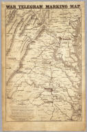
Author
Prang, L. & Co.
Full Title
War Telegram Marking Map. L. Prang & Co. Print Publishers, 159, Washington St. Boston ... Entered ... 1862 by L. Prang & Co. ... Massachusetts.
List No
4682.000
Note
In the "Explanations" below the map Prang states that this is "a map to mark the change of positions of the Union forces in red pencil and the rebel forces in blue, on the receipt of every telegram from the seat of war..." He goes on to say that he will furnish the necessary pencils and that "with the aid of a little soft bread" prior markings can be erased to show the latest developments. Printed in brown ink, showing the area between Richmond and Washington in good detail.
Author
Phelps & Watson
Full Title
Phelps & Watson's Historical And Military Map Of The Border & Southern States. Published By Phelps & Watson, 18 Beekman St. New York, 1863 ... Entered ... 1862 by Phelps & Watson ... New York.
List No
3147.001
Note
1st edition, copyright 1862. Later editions in 1864, 65, and 67. The map is the same as the 1864 edition, except that the list of Battles is for 1862 and 1863 only and the publisher's address is 18 instead of 16 Beekman Street. There are also blue dots on this edition only for the population statistics in each state. Full color by state. Map is folded into orange card board covers 17x11 with "New Historical War Map" printed in black.
Author
Perrine, Charles O.
Full Title
Perrine's New Topographical War Map Of The Southern States. Taken from the latest Government Surveys and Official Reports. E.R. Jewett & Co., Engravers, Buffalo, N.Y. Entered ... 1863, by C.O. Perrine ... Indiana. (inset) Southern Part Of Florida.
List No
5412.001
Note
Accompanies "A Concise History of the War" by Capt. John S. Bishop. Battles in the text are dated from January, 1861, to November, 1863. Text is stereotyped by the Franklin Type Foundry, Cincinnati. Map has printed outline color by state. Covers are orange card board 15x10 with "Perrine's New Topographical War Map Of The Southern States With A Chronology Of The Great Rebellion ... R.R. Landon, Agt., Chicago, Ill. E.R. Jewett & Co. Eng. Buffalo, N.Y. Price, 50 cts. Sent, Post-Paid." printed in black.
1-5 of 5
|