|
REFINE
Media Group: Copy of San Francisco Street Maps
1-82 of 82
Author
[Eddy, William M., Jones, William Carey]
Full Title
Official Map of San Francisco, Compiled from the Field Notes of the Official Re-Survey made by William M. Eddy. Surveyor of the Town of San Francisco, California. 1849. S.W. Higgins. Draftn. Copied by P.M. McGill C.E. & Draftn. Washington. C.B. Graham lith. Washington, D.C.
List No
2321.001
Note
Map is without color except for three small sections that show a grant to Senora Briones, the claim of the heirs of Col. J.A. King, and the claim of Senor Pana under a Mexican grant.
Author
Britton & Rey
Full Title
Map of San Francisco, Compiled from latest Surveys & containing all late extensions & Division of Wards. Published By Britton & Rey, San Francisco Cal.
List No
4333.000
Note
Letter sheet map showing the "Lately planket (sic) Streets" and the original shoreline. Streeter estimates the date by comparison with the Butler and Zakreski maps, which are earlier and later, respectively. With a vignette of an untitled building in the lower right corner. This copy was owned by the noted San Francisco collector Dr. Alexander Thomas Leonard, with his signature and notes on the verso of the board the map is mounted on. According to Sally Woodbridge the firm of of Page, Bacon & Co., which owned the building in the lower right corner was at the top of the banking heap in 1852; it was est. in 1849 as a branch of a St. Louis bank. In the financial panic of 1855 it suffered a disastrous run and was ruined along with many other banks.
Author
Bache, A. D.
Full Title
U.S. Coast Survey A.D. Bache, Superintendent, city of San Francisco and its vicinity, California. From a trigonometrical survey by R.D. Cutts, assistant. Topography by A.F. Rodgers sub-assistant. Hydrography by the party under the command of Lieut. James Alden U.S.N. Asst. 1853. U.S. Coast Survey Office. Verified I.I. Stevens ... Outlines and Topography engraved by Max. F.O. Strobel; Lettering by E.F. Woodward. Electrotype copy no. 1 by G. Mathiot, U.S.C.S.
List No
2470.053
Note
Vogdes shows this as the first edition. Map is without color. Relief shown by hachures; depths by soundings. Shows buildings, etc. In upper margin "Presented under authority of an act of Congress of the United States of June 3d 1844 by direction of the Treasury Department, A.D. Bache Superintendent Coast Survey."
Author
[Britton & Co., Hoadley, Milo]
Full Title
Map of the Beideman Tract lots & blocks according to official map of the Western Addition. Drawn from actual survey by M. Hoadley. ... Lith. Britton & Co. To be sold at public auction, on Saturday, Oct. 6th, 1860 at 12 o'clock M. at Platts Music Hall. By H.A. Cobb and R.H. Sinton, real estate auctrs. (with) Map of the city of San Francisco. Published by Britton & Co., Lithographers, Montgomery St. cor. of Comml. sts., San Francisco.
List No
4780.000
Note
Scarce and early land sale map with a very early issue of Britton & Co.'s "Map of the City of San Francisco" and below it on the same sheet a larger "Map of the Beideman Tract..." Beideman owned several large parcels of land in the emerging areas of the city and this tract was one of the earliest to be sold in the newly annexed Western Addition. The Britton & Co. Map of San Francisco is the earliest issue that we have seen, followed by several issues in 1863 to 1867 by Gensoul and the San Francisco Municipal Reports and the San Francisco Directory (see our copies under Gensoul). The Norris catalog lists an 1859 Map of Hayes Tract also by M. Hoadley with lots to be sold at auction by H.A. Cobb, but the San Francisco map is not printed above the Hayes Tract map. One of the earliest San Francisco land sales maps. Covers area bounded by Laguna, Bush, Larkin and McAllister streets. Casastral map.
Author
[Langley, Henry G., Wackenreuder, V.]
Full Title
City And County Of San Francisco. Compiled From Official Surveys And Sectionalized In Accordance With U.S. Surveys. Drawn By V. Wackenreuder, C.E. 1861. Published By Henry G. Langley For the San Francisco Directory. Entered ... 1861 By Henry G. Langley ... California. Britton & Co. Print. (with 3 inset maps of the Farrallon Islands).
List No
3867.000
Note
First map of the city to be included in Langley's directory. Early map to show the western and southern parts of the peninsula, with the land grants, and full topography. Also shows the northern part of San Mateo County and a small part of Marin County. Three insets show the Farrallon Islands. Directory not present. Map is without color.
Author
Allardt, G. F.
Full Title
Map no. 3. Salt marsh and tide lands situate in the city and county of San Francisco. To be sold at public auction by order of the Board of Tide Land Commissioners by Talbert & Leet, auctioneers, at their sales rooms no. 526 California Street, San Francisco. Sale to commence Friday Nov. 26th, 1869. B.F. Washington, H.P. Coon, L.L Bullock, Wm. S. Byrne, Secretary, Tide Land Commissioners. G.F. Allardt, Surveyor & Chief Engineer. C.H. Baker Lith., S.F.
List No
3970.000
Note
Cadastral map showing drainage, block and lot numbers, railroads, wharves, etc. Covers area from China Basin to Islais Creek. One of a series of maps published between 1869 and 1873 showing tidelands to be sold by order of the Board of Tide Land Commissioners.
Author
Bancroft, A.L.
Full Title
Bancroft's Official Guide Map Of City And County Of San Francisco, Compiled From Official Maps In Surveyor's Office. Published by A.L. Bancroft & Co. ... San Francisco, 1873. Entered ... 1873, by A.L. Bancroft & Company ... Washington, D.C. (inset) Skeleton Map Showing the relative position of San Francisco to the Surrounding Country.
List No
0045.001
Note
1st edition 1872. Map is folded into dark brown cloth covers 16x10.5 with "Bancroft's Guide Map Of The City And County Of San Francisco." stamped in gilt.
Author
Langley, Henry G.
Full Title
Map of San Francisco from the latest surveys. Engraved expressly for the San Francisco Directory. 1873. Lith. Britton & Rey, S.F.
List No
4353.000
Note
Removed from the San Francisco Directory (not present here). Montgomery Avenue has been added in North Beach (when compared to the 1870 edition). Map is without color. Shows wards, railroads, street railroads, cemeteries, military reservations, etc.
Author
Allardt, G. F.
Full Title
Sale map no. 12. Salt marsh and tide lands situate in the city and county of San Francisco, state of California. To be sold at public auction by order of the Board of Tide Land Commissioners ... at the sales rooms of Greenebaum & Co., auctioneers, nos. 115 & 117 Bush Street, San Francisco. Sale to commence Tuesday, March 4th, 1873. R.P. Johnson, Edgar Briggs, C.M. Stratton, Board of Tide Land Commissioners. J.M. Currier, Secretary. G.F. Allardt, Chief Engineer.
List No
3971.000
Note
Another tide lands sale map, this one showing two separate areas titled "Salt Marsh and Tide Lands at North Beach" and "Salt Marsh and Tide Lands Along Mission Creek and Mission Bay." Shows drainage, block and lot numbers, etc. Covers area bounded generally by Mission, 20th, Mississippi, and Channel Streets; covers area bounded by the Bay, Webster and Lombard Streets, and the Presidio. Cadastral maps. Scale of 2nd map 1:6,000.
Full Title
Map of the city and county of San Francisco. (Compiled and published by Wm. P. Humphreys & Co., A.B. Holcombe, W.C. Kewen. Eng. by Worley & Bracher ... Phila, Pa. Printed by F. Bourquin ... Phila, Pa. 1876.)
List No
0329.001
Note
Hand col. index map. Includes explanation for plat maps.
Full Title
Plat no. 1 (San Francisco. Compiled and published by Wm. P. Humphreys & Co., A.B. Holcombe, W.C. Kewen. Eng. by Worley & Bracher ... Phila, Pa. Printed by F. Bourquin ... Phila, Pa. 1876.)
List No
0329.002
Note
Hand col. map. Relief shown by spot heights. Shows block and lot numbers, wharves, sewers, etc. Covers area east from Kearney and North of Washington. Oriented with north toward lower right. David Rumsey Collection copy has additions by hand.
Full Title
Plat no. 2 (San Francisco. Compiled and published by Wm. P. Humphreys & Co., A.B. Holcombe, W.C. Kewen. Eng. by Worley & Bracher ... Phila, Pa. Printed by F. Bourquin ... Phila, Pa. 1876.)
List No
0329.003
Note
Hand col. map. Relief shown by spot heights. Shows block and lot numbers, sewers, etc. Covers area bounded by Kearney, Washington, Embarcadero, Market and California. Oriented with north toward lower right. David Rumsey Collection copy has additions by hand.
Full Title
Plat no. 3 (San Francisco. Compiled and published by Wm. P. Humphreys & Co., A.B. Holcombe, W.C. Kewen. Eng. by Worley & Bracher ... Phila, Pa. Printed by F. Bourquin ... Phila, Pa. 1876.)
List No
0329.004
Note
Hand col. map. Relief shown by spot heights. Shows block and lot numbers, sewers, etc. Covers area bounded by California, Market and Kearney. Oriented with north toward upper right. David Rumsey Collection copy has additions by hand.
Full Title
Plat no. 4 (San Francisco. Compiled and published by Wm. P. Humphreys & Co., A.B. Holcombe, W.C. Kewen. Eng. by Worley & Bracher ... Phila, Pa. Printed by F. Bourquin ... Phila, Pa. 1876.)
List No
0329.005
Note
Hand col. map. Relief shown by spot heights. Shows block and lot numbers, sewers, etc. Covers area bounded by California, Larkin and the Bay. Oriented with north toward upper right. David Rumsey Collection copy has additions by hand.
Full Title
Plat no. 5 (San Francisco. Compiled and published by Wm. P. Humphreys & Co., A.B. Holcombe, W.C. Kewen. Eng. by Worley & Bracher ... Phila, Pa. Printed by F. Bourquin ... Phila, Pa. 1876.)
List No
0329.006
Note
Hand col. map. Relief shown by spot heights. Shows block and lot numbers, sewers, etc. Covers area bounded by Francisco, Kearney, Vallejo and Larkin including Washington Square. Oriented with north toward upper right. David Rumsey Collection copy has additions by hand.
Full Title
Plat no. 6. Plat no. 7 (San Francisco. Compiled and published by Wm. P. Humphreys & Co., A.B. Holcombe, W.C. Kewen. Eng. by Worley & Bracher ... Phila, Pa. Printed by F. Bourquin ... Phila, Pa. 1876.)
List No
0329.007
Note
Two hand col. maps on 1 sheet. Relief shown by spot heights. Show block and lot numbers, sewers, etc. Cover area bounded by Vallejo, Kearney, Pine and Larkin including Portsmouth Square. David Rumsey Collection copy has additions by hand.
Full Title
Plat no. 8 (San Francisco. Compiled and published by Wm. P. Humphreys & Co., A.B. Holcombe, W.C. Kewen. Eng. by Worley & Bracher ... Phila, Pa. Printed by F. Bourquin ... Phila, Pa. 1876.)
List No
0329.008
Note
Hand col. map. Relief shown by spot heights. Shows block and lot numbers, sewers, etc. Covers area bounded by Pine, Kearney, Market, Ellis and Larkin including Union Square. David Rumsey Collection copy has additions by hand.
Full Title
Plat no. 9 (San Francisco). (with) Plan of pumping district. (Compiled and published by Wm. P. Humphreys & Co., A.B. Holcombe, W.C. Kewen. Eng. by Worley & Bracher ... Phila, Pa. Printed by F. Bourquin ... Phila, Pa. 1876.)
List No
0329.009
Note
Hand col. map. with inset. Relief shown by spot heights. Shows block and lot numbers, sewers, etc. Covers area bounded by Ellis, Market and Larkin including City Hall. Inset map covers area bounded by Greenwich, Embarcadero, Market, Montgomery, Jackson and Sansome, and shows iron flushing pipe, tank and engine house.; scale [ca. 1:4,800] David Rumsey Collection copy has additions by hand.
Full Title
Plat no. 10 (San Francisco. Compiled and published by Wm. P. Humphreys & Co., A.B. Holcombe, W.C. Kewen. Eng. by Worley & Bracher ... Phila, Pa. Printed by F. Bourquin ... Phila, Pa. 1876.)
List No
0329.010
Note
Hand col. map. Relief shown by spot heights. Shows block and lot numbers, sewers, wharves, etc. Covers area bounded by Market , Embarcadero, Harrison and 2nd.
Full Title
Plat no. 11 (San Francisco. (Compiled and published by Wm. P. Humphreys & Co., A.B. Holcombe, W.C. Kewen. Eng. by Worley & Bracher ... Phila, Pa. Printed by F. Bourquin ... Phila, Pa. 1876.)
List No
0329.011
Note
Hand col. map. Relief shown by spot heights. Shows block and lot numbers, sewers, etc. Covers area bounded by Market , 2nd, Harrison and 7th.
Full Title
Plat no. 12 (San Francisco. (Compiled and published by Wm. P. Humphreys & Co., A.B. Holcombe, W.C. Kewen. Eng. by Worley & Bracher ... Phila, Pa. Printed by F. Bourquin ... Phila, Pa. 1876.)
List No
0329.012
Note
Hand col. map. Relief shown by spot heights. Shows block and lot numbers, sewers, wharves, etc. Covers area bounded by Harrison, Steuart, King and 3rd including South Park.
Full Title
Plat no. 13 (San Francisco. (Compiled and published by Wm. P. Humphreys & Co., A.B. Holcombe, W.C. Kewen. Eng. by Worley & Bracher ... Phila, Pa. Printed by F. Bourquin ... Phila, Pa. 1876.)
List No
0329.013
Note
Hand col. map. Relief shown by spot heights. Shows block and lot numbers, sewers, wharves, railroad, etc. Covers area bounded by Harrison, 3rd, Channel St. and 7th.
Full Title
Plat no. 14 (San Francisco. (Compiled and published by Wm. P. Humphreys & Co., A.B. Holcombe, W.C. Kewen. Eng. by Worley & Bracher ... Phila, Pa. Printed by F. Bourquin ... Phila, Pa. 1876.)
List No
0329.014
Note
Hand col. map. Relief shown by spot heights. Shows block and lot numbers, sewers, etc. Covers area bounded by Lewis, Larkin, Chestnut and Steiner including Lobos Square (Moscone Recreation Center) , Alcatraz Square and Fort Mason. David Rumsey Collection copy has additions by hand.
Full Title
Plat no. 15 (San Francisco. (Compiled and published by Wm. P. Humphreys & Co., A.B. Holcombe, W.C. Kewen. Eng. by Worley & Bracher ... Phila, Pa. Printed by F. Bourquin ... Phila, Pa. 1876.)
List No
0329.015
Note
Hand col. map. Relief shown by spot heights. Shows block and lot numbers, sewers, etc. Covers area bounded by Chestnut, Larkin, Broadway and Steiner. David Rumsey Collection copy has additions by hand.
Full Title
Plat no. 16 (San Francisco. (Compiled and published by Wm. P. Humphreys & Co., A.B. Holcombe, W.C. Kewen. Eng. by Worley & Bracher ... Phila, Pa. Printed by F. Bourquin ... Phila, Pa. 1876.)
List No
0329.016
Note
Hand col. map. Relief shown by spot heights. Shows block and lot numbers, sewers, etc. Covers area bounded by Broadway, Larkin, Pine and Steiner including Lafayette Park. David Rumsey Collection copy has additions by hand.
Full Title
Plat no. 17 (San Francisco. (Compiled and published by Wm. P. Humphreys & Co., A.B. Holcombe, W.C. Kewen. Eng. by Worley & Bracher ... Phila, Pa. Printed by F. Bourquin ... Phila, Pa. 1876.)
List No
0329.017
Note
Hand col. map. Relief shown by spot heights. Shows block and lot numbers, sewers, etc. Covers area bounded by Pine, Larkin, Eddy and Steiner. David Rumsey Collection copy has additions by hand.
Full Title
Plat no. 18 (San Francisco. (Compiled and published by Wm. P. Humphreys & Co., A.B. Holcombe, W.C. Kewen. Eng. by Worley & Bracher ... Phila, Pa. Printed by F. Bourquin ... Phila, Pa. 1876.)
List No
0329.018
Note
Hand col. map. Relief shown by spot heights. Shows block and lot numbers, sewers, etc. Covers area bounded by Eddy, Larkin, Fell and Steiner, including Jefferson Square. David Rumsey Collection copy has additions by hand.
Full Title
Plat no. 19 (San Francisco. (Compiled and published by Wm. P. Humphreys & Co., A.B. Holcombe, W.C. Kewen. Eng. by Worley & Bracher ... Phila, Pa. Printed by F. Bourquin ... Phila, Pa. 1876.)
List No
0329.019
Note
Hand col. map. Relief shown by spot heights. Shows block and lot numbers, sewers, etc. Covers area bounded by Fell, Market, Ridley and Steiner, including Protestant Orphan Asylum. David Rumsey Collection copy has additions by hand.
Full Title
Plat no. 20 (San Francisco. (Compiled and published by Wm. P. Humphreys & Co., A.B. Holcombe, W.C. Kewen. Eng. by Worley & Bracher ... Phila, Pa. Printed by F. Bourquin ... Phila, Pa. 1876.)
List No
0329.020
Note
Hand col. map. Relief shown by spot heights. Shows block and lot numbers, sewers, shoreline, etc. Covers area bounded by the Bay, Steiner, Chestnut and Charter line of 1857 (Divisadero). David Rumsey Collection copy has additions by hand.
Full Title
Plat no. 21 (San Francisco. (Compiled and published by Wm. P. Humphreys & Co., A.B. Holcombe, W.C. Kewen. Eng. by Worley & Bracher ... Phila, Pa. Printed by F. Bourquin ... Phila, Pa. 1876.)
List No
0329.021
Note
Hand col. map. Relief shown by spot heights. Shows block and lot numbers, sewers, etc. Covers area bounded by Chestnut, Steiner, Broadway and Charter line of 1857 (Divisadero). David Rumsey Collection copy has additions by hand.
Full Title
Plat no. 22 (San Francisco. (Compiled and published by Wm. P. Humphreys & Co., A.B. Holcombe, W.C. Kewen. Eng. by Worley & Bracher ... Phila, Pa. Printed by F. Bourquin ... Phila, Pa. 1876.)
List No
0329.022
Note
Hand col. map. Relief shown by spot heights. Shows block and lot numbers, sewers, etc. Covers area bounded by Broadway, Steiner, Pine and Charter line of 1857 (Divisadero), including Alta Plaza. David Rumsey Collection copy has additions by hand.
Full Title
Plat no. 23 (San Francisco. (Compiled and published by Wm. P. Humphreys & Co., A.B. Holcombe, W.C. Kewen. Eng. by Worley & Bracher ... Phila, Pa. Printed by F. Bourquin ... Phila, Pa. 1876.)
List No
0329.023
Note
Hand col. map. Relief shown by spot heights. Shows block and lot numbers, sewers, etc. Covers area bounded by Pine, Steiner, Eddy and Charter line of 1857 (Divisadero), including Hamilton Square. David Rumsey Collection copy has additions by hand.
Full Title
Plat no. 24 (San Francisco. (Compiled and published by Wm. P. Humphreys & Co., A.B. Holcombe, W.C. Kewen. Eng. by Worley & Bracher ... Phila, Pa. Printed by F. Bourquin ... Phila, Pa. 1876.)
List No
0329.024
Note
Hand col. map. Relief shown by spot heights. Shows block and lot numbers, sewers, etc. Covers area bounded by Eddy, Steiner, Fell and Charter line of 1857 (Divisadero), including Alamo Square. David Rumsey Collection copy has additions by hand.
Full Title
Plat no. 25 (San Francisco. (Compiled and published by Wm. P. Humphreys & Co., A.B. Holcombe, W.C. Kewen. Eng. by Worley & Bracher ... Phila, Pa. Printed by F. Bourquin ... Phila, Pa. 1876.)
List No
0329.025
Note
Hand col. map. Relief shown by spot heights. Shows block and lot numbers, sewers, etc. Covers area bounded by Fell, Steiner, Ridley and Charter line of 1857 (Divisadero), including a hospital lot. David Rumsey Collection copy has additions by hand.
Full Title
Plat no. 26. Plat no. 27 (San Francisco. (Compiled and published by Wm. P. Humphreys & Co., A.B. Holcombe, W.C. Kewen. Eng. by Worley & Bracher ... Phila, Pa. Printed by F. Bourquin ... Phila, Pa. 1876.)
List No
0329.026
Note
Two hand col. maps on 1 sheet. Relief shown by spot heights. Show block and lot numbers, sewers, etc. Cover areas bounded by Channel, China Basin, Merrimac and 6th St.; and Central Basin, Bay, Napa and Michigan.
Full Title
Plat no. 28 (San Francisco. (Compiled and published by Wm. P. Humphreys & Co., A.B. Holcombe, W.C. Kewen. Eng. by Worley & Bracher ... Phila, Pa. Printed by F. Bourquin ... Phila, Pa. 1876.)
List No
0329.027
Note
Hand col. map. Relief shown by spot heights. Shows block and lot numbers, sewers, etc. Covers area bounded by Channel, the Bay, Santa Clara (17th) and Rhode Island. "Note: Upper numbers of blocks are from the official map." David Rumsey Collection copy has additions by hand.
Full Title
Plat no. 29 (San Francisco. (Compiled and published by Wm. P. Humphreys & Co., A.B. Holcombe, W.C. Kewen. Eng. by Worley & Bracher ... Phila, Pa. Printed by F. Bourquin ... Phila, Pa. 1876.)
List No
0329.028
Note
Hand col. map. Relief shown by spot heights. Shows block and lot numbers, sewers, shoreline, etc. Covers area bounded by Santa Clara, Georgia, Charter line of 1851, and Rhode Island, including Jackson Park.
Full Title
Plat no. 30 (San Francisco. (Compiled and published by Wm. P. Humphreys & Co., A.B. Holcombe, W.C. Kewen. Eng. by Worley & Bracher ... Phila, Pa. Printed by F. Bourquin ... Phila, Pa. 1876.)
List No
0329.029
Note
Hand col. map. Relief shown by spot heights. Shows block and lot numbers, sewers, etc. Covers area bounded by Market, 7th, Harrison, 16th and Pearl. Oriented with north toward upper right. David Rumsey Collection copy includes additions by hand.
Full Title
Plat no. 31 (San Francisco. (Compiled and published by Wm. P. Humphreys & Co., A.B. Holcombe, W.C. Kewen. Eng. by Worley & Bracher ... Phila, Pa. Printed by F. Bourquin ... Phila, Pa. 1876.)
List No
0329.030
Note
Hand col. map. Relief shown by spot heights. Shows block and lot numbers, sewers, Mission Creek, etc. Covers area bounded by Harrison, 7th., Channel St. and Alameda. Oriented with north toward upper right. David Rumsey Collection copy includes additions by hand.
Full Title
Plat no. 32 (San Francisco. (Compiled and published by Wm. P. Humphreys & Co., A.B. Holcombe, W.C. Kewen. Eng. by Worley & Bracher ... Phila, Pa. Printed by F. Bourquin ... Phila, Pa. 1876.)
List No
0329.031
Note
Hand col. map. Relief shown by spot heights. Shows block numbers, sewers, Mission Creek, etc. Covers area bounded by 8th, Rhode Island, Mariposa, 17th and Mission. David Rumsey Collection copy includes additions by hand (changes in street names).
Full Title
Plat no. 33 (San Francisco. (Compiled and published by Wm. P. Humphreys & Co., A.B. Holcombe, W.C. Kewen. Eng. by Worley & Bracher ... Phila, Pa. Printed by F. Bourquin ... Phila, Pa. 1876.)
List No
0329.032
Note
Hand col. map. Relief shown by spot heights. Shows block numbers, sewers, etc. Covers area bounded by 17th, Rhode Island, 21st and Mission, including Buena Vista Park (i.e. McKinley Square). David Rumsey Collection copy includes additions by hand.
Full Title
Plat no. 34 (San Francisco. (Compiled and published by Wm. P. Humphreys & Co., A.B. Holcombe, W.C. Kewen. Eng. by Worley & Bracher ... Phila, Pa. Printed by F. Bourquin ... Phila, Pa. 1876.)
List No
0329.033
Note
Hand col. map. Relief shown by spot heights. Shows block numbers, sewers, etc. Covers area bounded by Ridley (Duboce), Mission, 17th, Charter Line of 1851 (Castro). David Rumsey Collection copy includes additions by hand.
Full Title
Plat no. 35 (San Francisco. (Compiled and published by Wm. P. Humphreys & Co., A.B. Holcombe, W.C. Kewen. Eng. by Worley & Bracher ... Phila, Pa. Printed by F. Bourquin ... Phila, Pa. 1876.)
List No
0329.034
Note
Hand col. map. Relief shown by spot heights. Shows block numbers, sewers, etc. Covers area bounded by 17th, Mission, 22nd and Castro, including Home of Place Cemetery and Sherith Israel Cemetery (Dolores Park). David Rumsey Collection copy includes additions by hand.
Full Title
Plat no. 36 (San Francisco. (Compiled and published by Wm. P. Humphreys & Co., A.B. Holcombe, W.C. Kewen. Eng. by Worley & Bracher ... Phila, Pa. Printed by F. Bourquin ... Phila, Pa. 1876.)
List No
0329.035
Note
Hand col. map. Relief shown by spot heights. Shows block numbers, sewers, shoreline, Islais and Precita creeks, etc. Covers area bounded by 20th, water front, Calaveras and Columbia (Florida).
Full Title
Plat no. 37 (San Francisco. (Compiled and published by Wm. P. Humphreys & Co., A.B. Holcombe, W.C. Kewen. Eng. by Worley & Bracher ... Phila, Pa. Printed by F. Bourquin ... Phila, Pa. 1876.)
List No
0329.036
Note
Hand col. map. Relief shown by spot heights. Shows block numbers, sewers, shoreline, etc. Covers area bounded by Islais, water front, 23rd, S, including India Basin.
Full Title
Plat no. 38 (San Francisco. (Compiled and published by Wm. P. Humphreys & Co., A.B. Holcombe, W.C. Kewen. Eng. by Worley & Bracher ... Phila, Pa. Printed by F. Bourquin ... Phila, Pa. 1876.)
List No
0329.037
Note
Hand col. map. Relief shown by spot heights. Shows block numbers, sewers, shoreline, dry dock, etc. Covers area bounded by the Bay, South Basin, 37th and L.
Full Title
Plat no. 39. Plat no. 40 (San Francisco. (Compiled and published by Wm. P. Humphreys & Co., A.B. Holcombe, W.C. Kewen. Eng. by Worley & Bracher ... Phila, Pa. Printed by F. Bourquin ... Phila, Pa. 1876.)
List No
0329.038
Note
Two hand col. maps on 1 sheet. Relief shown by spot heights. Show block numbers, sewers, etc. Cover areas bounded by India Basin, southern city boundary, and F; and 21st, Potrero, 30th and Castro.
Full Title
Plat no. 41 (San Francisco. (Compiled and published by Wm. P. Humphreys & Co., A.B. Holcombe, W.C. Kewen. Eng. by Worley & Bracher ... Phila, Pa. Printed by F. Bourquin ... Phila, Pa. 1876.)
List No
0329.039
Note
Hand col. map. Relief shown by spot heights. Shows block numbers, sewers, etc. Covers area bounded by Clipper, 26th, Arkansas, Crescent, Noe, including Islais Creek Channel, Holly Park and Fairmount Plaza.
Full Title
Plat no. 42 (San Francisco. (Compiled and published by Wm. P. Humphreys & Co., A.B. Holcombe, W.C. Kewen. Eng. by Worley & Bracher ... Phila, Pa. Printed by F. Bourquin ... Phila, Pa. 1876.)
List No
0329.040
Note
Hand col. map. Shows block numbers, etc. Covers College Homestead, Excelsior Homestead and University Homestead associations, including "University College Grounds."
Full Title
Plat no. 43 (San Francisco. (Compiled and published by Wm. P. Humphreys & Co., A.B. Holcombe, W.C. Kewen. Eng. by Worley & Bracher ... Phila, Pa. Printed by F. Bourquin ... Phila, Pa. 1876.)
List No
0329.041
Note
Hand col. map. Relief shown by spot heights. Shows block numbers, shoreline, etc. Covers part of Rancho Canada de Guadalupe Rodeo Viejo y Visitacion and Visitacion Valley area.
Full Title
Plat no. 44 (San Francisco. (Compiled and published by Wm. P. Humphreys & Co., A.B. Holcombe, W.C. Kewen. Eng. by Worley & Bracher ... Phila, Pa. Printed by F. Bourquin ... Phila, Pa. 1876.)
List No
0329.042
Note
Hand col. map. Relief shown by spot heights. Shows block numbers, sewers, etc. Covers area bounded by Frederick, Castro, 20th St. and 11th Ave., including part of San Miguel Rancho, and Buena Vista Park, Corona Heights, Eureka Valley , Ashbury Heights and inner Sunset District.
Full Title
Plat no. 45 (San Francisco. (Compiled and published by Wm. P. Humphreys & Co., A.B. Holcombe, W.C. Kewen. Eng. by Worley & Bracher ... Phila, Pa. Printed by F. Bourquin ... Phila, Pa. 1876.)
List No
0329.043
Note
Hand col. map. Relief shown by spot heights. Shows block numbers, sewers, etc. Covers area bounded by 20th St., Castro, 30th St., 12th Ave. and Noriega, including San Miguel Rancho, Alms House Tract, Noe Valley and Laguna Honda.
Full Title
Plat no. 46 (San Francisco. (Compiled and published by Wm. P. Humphreys & Co., A.B. Holcombe, W.C. Kewen. Eng. by Worley & Bracher ... Phila, Pa. Printed by F. Bourquin ... Phila, Pa. 1876.)
List No
0329.044
Note
Hand col. map. Shows block numbers, etc. Covers San Miguel Rancho, Glen Park, Excelsior area, including House of Refuge Lot, Belle Roche City, Academy Tract and Fairmount Tract.
Full Title
Plat no. 47 (San Francisco. (Compiled and published by Wm. P. Humphreys & Co., A.B. Holcombe, W.C. Kewen. Eng. by Worley & Bracher ... Phila, Pa. Printed by F. Bourquin ... Phila, Pa. 1876.)
List No
0329.045
Note
Hand col. map. Shows block numbers, etc. Covers parts of San Miguel Rancho and Rancho Canada de Guadalupe Rodeo Viejo y Visitacion, Rail Road Homestead, Excelsior Homestead Association, West End Homestead, Lake Geneva, and San Miguel City.
Full Title
Plat no. 48 (San Francisco. (Compiled and published by Wm. P. Humphreys & Co., A.B. Holcombe, W.C. Kewen. Eng. by Worley & Bracher ... Phila, Pa. Printed by F. Bourquin ... Phila, Pa. 1876.)
List No
0329.046
Note
Hand col. map. Shows block numbers, etc. Covers parts of San Miguel Rancho near San Miguel Toll Road and Ocean House Road in the Ingleside District.
Full Title
Plat no. 49 (San Francisco. (Compiled and published by Wm. P. Humphreys & Co., A.B. Holcombe, W.C. Kewen. Eng. by Worley & Bracher ... Phila, Pa. Printed by F. Bourquin ... Phila, Pa. 1876.)
List No
0329.047
Note
Hand col. map. Shows block numbers, etc. Covers parts of San Miguel Rancho and Rancho Laguna de la Merced in the Ingleside District, including San Miguel City, City Land Association, Railroad Homestead, West End Homestead and Lake Geneva.
Full Title
Plat no. 50 (San Francisco. (Compiled and published by Wm. P. Humphreys & Co., A.B. Holcombe, W.C. Kewen. Eng. by Worley & Bracher ... Phila, Pa. Printed by F. Bourquin ... Phila, Pa. 1876.)
List No
0329.048
Note
Hand col. map. Shows block numbers, etc. Covers Sunset District bounded by H (Lincoln), 12th Ave., P (Pacheco) and 44th Ave.
Full Title
Plat no. 51 (San Francisco. (Compiled and published by Wm. P. Humphreys & Co., A.B. Holcombe, W.C. Kewen. Eng. by Worley & Bracher ... Phila, Pa. Printed by F. Bourquin ... Phila, Pa. 1876.)
List No
0329.049
Note
Hand col. map. Shows block numbers, etc. Covers Sunset District bounded by P (Pacheco), 12th Ave., Sloat, and 44th Ave, including Stern Grove, Pine Lake Park and Laguna Puerca.
Full Title
Plat no. 52 (San Francisco. (Compiled and published by Wm. P. Humphreys & Co., A.B. Holcombe, W.C. Kewen. Eng. by Worley & Bracher ... Phila, Pa. Printed by F. Bourquin ... Phila, Pa. 1876.)
List No
0329.050
Note
Hand col. map. Shows block numbers, etc. Covers Lake Merced-Rancho Laguna de la Merced area from ocean to 17th Ave.
Full Title
Plat no. 53 (San Francisco. (Compiled and published by Wm. P. Humphreys & Co., A.B. Holcombe, W.C. Kewen. Eng. by Worley & Bracher ... Phila, Pa. Printed by F. Bourquin ... Phila, Pa. 1876.)
List No
0329.051
Note
Hand col. map. Shows block numbers, etc. Covers southern arm of Lake Merced in the Rancho Laguna de la Merced.
Full Title
Plat no. 54. Plat no. 55 (San Francisco. (Compiled and published by Wm. P. Humphreys & Co., A.B. Holcombe, W.C. Kewen. Eng. by Worley & Bracher ... Phila, Pa. Printed by F. Bourquin ... Phila, Pa. 1876.)
List No
0329.052
Note
Two hand col. maps on 1 sheet. Show block numbers, etc. Cover outer Sunset District from 44th Ave. west between Lincoln and Sloat, including outlet of Lake Merced.
Full Title
Plat no. 56 (San Francisco. (Compiled and published by Wm. P. Humphreys & Co., A.B. Holcombe, W.C. Kewen. Eng. by Worley & Bracher ... Phila, Pa. Printed by F. Bourquin ... Phila, Pa. 1876.)
List No
0329.053
Note
Hand col. map. Relief shown by spot heights. Shows block numbers, sewers, etc. Covers area bounded by Lewis, Charter Line of 1851 (Broderick), Broadway and Cherry, including part of the Presidio. David Rumsey Collection copy includes additions by hand.
Full Title
Plat no. 57 (San Francisco. (Compiled and published by Wm. P. Humphreys & Co., A.B. Holcombe, W.C. Kewen. Eng. by Worley & Bracher ... Phila, Pa. Printed by F. Bourquin ... Phila, Pa. 1876.)
List No
0329.054
Note
Hand col. map. Relief shown by spot heights. Shows block numbers, sewers, etc. Covers area bounded by Broadway, Charter Line of 1851 (Broderick), Turk and 15th Ave., including part of the Presidio, Mountain Lake Park, and Laurel Hill, Odd Fellows' and Calvary cemeteries. David Rumsey Collection copy includes additions by hand.
Full Title
Plat no. 58 (San Francisco. (Compiled and published by Wm. P. Humphreys & Co., A.B. Holcombe, W.C. Kewen. Eng. by Worley & Bracher ... Phila, Pa. Printed by F. Bourquin ... Phila, Pa. 1876.)
List No
0329.055
Note
Hand col. map. Relief shown by spot heights. Shows block numbers, sewers, etc. Covers area bounded by Turk, Charter Line of 1851 (Broderick), Frederick, Lincoln and 14th Ave., including the Masonic Cemetery and parts of Golden Gate Park (showing buildings, trails, etc.), Buena Vista Park, and Odd Fellows and Calvary cemeteries. David Rumsey Collection copy includes additions by hand.
Full Title
Plat no. 59 (San Francisco. (Compiled and published by Wm. P. Humphreys & Co., A.B. Holcombe, W.C. Kewen. Eng. by Worley & Bracher ... Phila, Pa. Printed by F. Bourquin ... Phila, Pa. 1876.)
List No
0329.056
Note
Hand col. map. Shows block numbers, etc. Covers area bounded by ocean, Fulton, 14th Ave. and Lincoln, including part of Golden Gate Park.
Full Title
Plat no. 60 (San Francisco. (Compiled and published by Wm. P. Humphreys & Co., A.B. Holcombe, W.C. Kewen. Eng. by Worley & Bracher ... Phila, Pa. Printed by F. Bourquin ... Phila, Pa. 1876.)
List No
0329.057
Note
Hand col. map. Relief shown by spot heights. Shows block numbers, sewers, etc. Covers part of the Richmond District Lake, 1st Ave., Fulton and 32nd Ave.
Full Title
Plat no. 61 (San Francisco. (Compiled and published by Wm. P. Humphreys & Co., A.B. Holcombe, W.C. Kewen. Eng. by Worley & Bracher ... Phila, Pa. Printed by F. Bourquin ... Phila, Pa. 1876.)
List No
0329.058
Note
Hand col. map. Shows block numbers, Cliff House, cemetery, etc. Covers area bounded by ocean, the Golden Gate and 31st Ave.
Full Title
Plat no. 62 (San Francisco. (Compiled and published by Wm. P. Humphreys & Co., A.B. Holcombe, W.C. Kewen. Eng. by Worley & Bracher ... Phila, Pa. Printed by F. Bourquin ... Phila, Pa. 1876.)
List No
0329.059
Note
Hand col. map. Covers Lobos Creek, Presidio area from 16th-30th avenues.
Full Title
Plat no. 63 (San Francisco. (Compiled and published by Wm. P. Humphreys & Co., A.B. Holcombe, W.C. Kewen. Eng. by Worley & Bracher ... Phila, Pa. Printed by F. Bourquin ... Phila, Pa. 1876.)
List No
0329.060
Note
Hand col. map. Relief shown by hachures. Shows block numbers, sewers, creek, wharfs, etc. Covers Fort Point, part of the Presidio and surroundings, from Greenwich St. north and Broderick St. west.
Author
Bancroft, A.L.
Full Title
Bancroft's Official Guide Map Of City And County Of San Francisco, Compiled From Official Maps In Surveyor's Office. Published by A.L. Bancroft & Co. ... San Francisco, 1881. Entered ... 1877, by A.L. Bancroft & Company ... Washington, D.C. (inset) Skeleton Map Showing the relative position of San Francisco to the Surrounding Country.
List No
2742.001
Note
Latest date in Phillips is 1877. Changes the directory of important buildings somewhat, compared to the 1873 edition. Covers are textured black paper over card board 16.5x11 with a pink paste down label reading "Bancroft's Map of the City & County Of San Francisco. A.L. Bancroft & Company, 721 Market Street, San Francisco, Cal. 1881."
Author
Post Publishing Company (San Francisco, Calif.)
Full Title
(Business map of San Francisco). Issued by Post Publishing Company, publishers of the Daily and Weekly Post, San Francisco, Cal. (1886?)
List No
3150.000
Note
Shows Blocks between Market, Jackson and Dupont. Lists every business on every block; includes street addresses, and has ads in a triangle below Market Street. This was probably an insert in the San Francisco Post newspaper. Printed without color. "Remarkable increase in circulation. 5,000 net gain since November 26, 1885." Oriented with north to right.
Author
Britton & Rey
Full Title
Britton & Rey's Guide Map of the City of San Francisco. 1887. Copyright. (with) Geo. F. Schild's Map Attachment. Patented Dec. 8th 1885.
List No
5567.001
Note
Map in full color. Shows the city with districts labeled. A patented fabric strip is attached to the cover. It allows the user to find a place in the index and then easily locate it on the map. The strip can also be removed and used to tell distance as it corresponds to the scale of the map. A past owner of the map has added red ink markings to the map. An index booklet and instructions for using the map attachment are included. Bound in red fabric with "Index to Street Guide Map of San Francisco, Cal. By Britton & Rey" in gold.
Author
Langley, Henry G.
Full Title
Guide Map Of The City Of San Francisco Compiled From The Official Surveys & Engraved Expressly For Langley's San Francisco Directory 1890. Copyright By Geo. B. Wilbur Receiver Of Painter & Co. 1890. McAfee, Baldwin & Hammond. Real Estate Agents And Auctioneers, 10 Montgomery Street, San Francisco. Lots For Sale In All Parts Of The City ...
List No
5315.001
Note
Ad for G.G. Wickson & Co. on verso. Map is printed in full color.
Author
South San Francisco Land & Improvement Co.
Full Title
South San Francisco Issued By The South San Francisco Land & Improvement Co. San Francisco, Cal. Plat Of South San Francisco. Rand, McNally & Co., Engravers, Chicago. Earnshaw & Punshon, Surveyors and Landscape Engineers, Cincinnati, Ohio.
List No
5293.000
Note
An early South San Francisco land promotion map. Very well executed. With full printed color. Date estimated.
Author
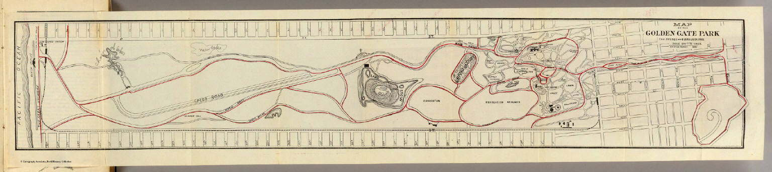
Blum, George W.
Full Title
Map of the Golden Gate Park, the Avenue and Buena Vista Park. 1895.
List No
1592.001
Note
Bike paths shown in red. The map has been updated in pencil, labeling "Chain of Lakes" and adding a new lake. A cross has also been added near Lake Stow.
Author
Rand McNally and Company
Full Title
Rand, McNally & Co.'s indexed atlas of the world map of San Francisco. Rand, McNally & Co.'s new business atlas map of San Francisco. Copyright, 1891 ... Rand, McNally & Co., Engravers, Chicago. (1897)
List No
3565.148
Note
Col. map. Shows major buildings, cemeteries, parks, flumes, street car lines, etc. Inset: Map of San Francisco and vicinity. Scale (ca. 1:450,000). Title in margin: Rand, McNally & Company's indexed atlas of the world.
Author
Rand McNally and Company
Full Title
Rand, McNally & Co.'s San Francisco. (with) Map of San Francisco and Vicinity.
List No
2844.078
Note
Tables of railroads and chief cities keyed to map. Vicinity map at scale 1:452,000.
Author
Chevalier, August
Full Title
The commercial, pictorial and tourist map of San Francisco, in colors and illustrated with litho-engraved pictures of all public buildings, parks, monuments, and recommended business houses, etc. Designed, engraved & copyrighted by Aug. Chevalier. Copyrighted 15th Dec. 1903 by Aug. Chevalier. 1st edition, 1904, August. Galloway Litho Co., S.F.
List No
3732.001
Note
Color lithographed map. Relief shown by hachures and contours. Vegetation shown in green. Also issued as rolled map and as a pocket map without the guidebook.
Author
Chevalier, August
Full Title
The "Chevalier" Commercial, Pictorial and Tourist Map of San Francisco From Latest U.S. Gov. and Official Surveys. Designed-Engraved And Copyrighted By Aug. Chevalier, Lithographer Publisher, San Francisco ... copyrighted 1911 ...
List No
0140.000
Note
1st edition was 1903. A very beautiful map of San Francisco showing contour lines; all important buildings and public improvements are drawn in vignettes on the map. At the bottom of the map is the publisher's statement: "This Map is an Improved and Enlarged Edition of The Commercial Pictorial and Tourist Map of San Francisco Copyrighted Dec. 1903 by August Chevalier. Similar Maps For Other Cities in the U.S. Are Being Made." "The Exposition City 1915"
Author
Rand McNally and Company
Full Title
Commercial Atlas of America. Rand McNally Standard Map of City and County of San Francisco. (with) San Francisco and Vicinity.
List No
5028.137
Note
Shows railroads and distances. Includes tables of principal cities and railroads, keyed to map. Relief shown by hachures. Inset of San Francisco and Vicinity at scale of 1:507,000
Author
[Auradou, A. L. (A. Leon), O'Shaughnessy, M. M. (Michael Maurice), 1864-1934, San Francisco (Calif.). Board of Public Works, Funk & Wagnalls Company.]
Full Title
Map of the city and county of San Francisco prepared by the Board of Public Works, M.M. O'Shaughnessy, City Engineer. A.L. Auradou, cartographer. Map issued October 15, 1927. Revised to Sept. 1, 1929.
List No
5289.000
Note
Relief shown by contours (in brown), hachures and spot heights. Shows block numbers, numbered piers, buildings in Golden Gate Park and the Presidio. Includes inset map showing city and county boundaries. "Dr. 7-3532.1"
Author
[H.M. Gousha Company, Standard Oil Company of California]
Full Title
Street map of San Francisco. Prepared for Standard Oil Company of California ... Copyright by the H.M. Gousha Company, Chicago, San Jose. Lithographed in U.S.A. Chevron Supreme Gasoline ... (inset) Downtown San Francisco.
List No
3264.001
Note
Relief shown by hachures and spot heights. Also covers Bayshore, Daly City, Brisbane and part of Colma. Indexed. Oil company give away. San Francisco just before the freeways. Map is printed in full color and folds into self wrappers 23 x 10. "478-5-9-AA," "9-AA-1953-1."
1-82 of 82
|