Author
Lucas, Fielding Jr.
Full Title
Comparative Height of the Principal Mountains and other Elevations in the World. J. Cone Sc. Published by F. Lucas Jr. Baltimore.
List No
4584.001
Note
Altitude shown for Western Hemisphere and Eastern Hemisphere in feet. Full color.
Author
Mitchell, Samuel Augustus
Full Title
(Covers to) A New American Atlas, Designed Principally To Illustrate The Geography Of The United States Of North America; In Which Every Country In Each State And Territory Of The Union Is Accurately Delineated, As Far As At Present Known: The Whole Compiled From The Latest And Most Authentic Information. Philadelphia: Published By Samuel Augustus Mitchell. 1831.
List No
3884A
Author
Mitchell, Samuel Augustus
Full Title
(Title Page to) A New American Atlas, Designed Principally To Illustrate The Geography Of The United States Of North America; In Which Every Country In Each State And Territory Of The Union Is Accurately Delineated, As Far As At Present Known: The Whole Compiled From The Latest And Most Authentic Information. Philadelphia: Published By Samuel Augustus Mitchell. 1831.
List No
3884B
Author
Mitchell, Samuel Augustus
Full Title
Map Of North America Including All The Recent Geographical Discoveries. Published by S. Augustus Mitchell Philadelphia. 1831. J.H. Young Sc.
List No
3884.001
Note
Full color by country.
Author
Mitchell, Samuel Augustus
Full Title
Map Of The United States Constructed From the latest Authorities. Published by S. Augustus Mitchell Philadelphia. 1831. J.H. Young Sc.
List No
3884.002
Note
Full color by state or territory.
Author
Mitchell, Samuel Augustus
Full Title
Map of Maine, New Hampshire And Vermont, Compiled From The Latest Authorities. Published by S. Augustus Mitchell Philadelphia. 1831. J.H. Young Sc. (inset) North Part of Maine.
List No
3884.003
Note
Full color by county.
Author
Mitchell, Samuel Augustus
Full Title
Map Of The State Of New York. Published by S. Augustus Mitchell Philadelphia. 1831. J.H. Young Sc. (inset) Map of the Hudson River from New York To Albany. (inset) Profile of the Levels of the Grand Erie Canal.
List No
3884.005
Note
Full color by county.
Author
Mitchell, Samuel Augustus
Full Title
Map Of Pennsylvania, New Jersey And Delaware. Constructed from the Latest Authorities. Published by S. Augustus Mitchell Philadelphia. 1831. Engraved by J.H. Young.
List No
3884.006
Note
Full color by county.
Author
Mitchell, Samuel Augustus
Full Title
Map of the States Of Ohio, Indiana & Illinois And Part Of Michigan Territory Compiled from the Latest Authorities. Published by S. Augustus Mitchell Philadelphia. 1831. J.H. Young Sc.
List No
3884.011
Note
Full color by county or territory.
Author
[Hagaman and Markham, Peabody, M.M.]
Full Title
Map Of The Village Of Auburn. Published By Hagaman & Markham 1837. Engraved by M.M. Peabody for the Publishers. (inset) Profile of the Grand Erie Canal.
List No
3545.000
Note
Scarce, unusual map of Auburn, New York. I can find no references to this beautiful map. A plan of the village is in the map's center, with large views of the Theological Seminary and the State Prison on the left and right corners. Nine views of public buildings are on the right, some of which have "J.J. Hagaman, Arch." written below. I presume this is our map maker Hagaman. Beneath the title is a profile of the Erie Canal. The entire map has a stark, black and white aspect, heightened by the view of the State Prison which has a black sky above it.
Author
Varle, Charles P.
Full Title
To The Citizens Of Philadelphia This New Plan Of The City And Its Environs Is respectfully dedicated By the Editor. 1802. P.C. Varle Geographer & Enginr. Del.
List No
5006.000
Note
A beautiful, early map of Philadelphia in full period color. The scale is given at 75 Perches to 1 inch. The city is shown from the Delaware River to the Schuylkil River with the environs on the north and south. 24 lettered references and 28 numbered references to important places and buildings are below the title and 24 wards are keyed in Roman numbers above the title. Many of the country houses and farms around the city are named, including Penn, Dr. Wistar, and other notable early residents. Three inset views show City Hall, the State House, Court House, Library, and Bank of the United States. The tile is surrounded by a decorative cartouche. The quality of the engraving is superb. Ristow mentions an undated edition that was possibly issued in the year Varle made the surveys, 1796, but more likely in 1802. Wheat and Brun list a c.1794 State I that has one less numbered building reference, no Roman numbered ward references, and "R. Scott Sculp. Philadelphia." This was Varle's first map published in the United States. Until 1807, Varle was known as Peter C. Varle; after 1807 he is known as Charles P. Varle.
Author
[Burr, David H., 1803-1875, Colton, J. H.]
Full Title
(Covers to) Texas.
List No
5024A
Author
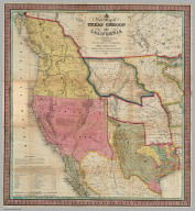
[Burr, David H., 1803-1875, Colton, J. H.]
Full Title
Texas, By David H. Burr. Published by J.H. Colton & Co. New-York. 1835 Engraved by S. Stiles & Co. N. York. Entered ... 1833, by J.H. Colton & Co. ... New York. (inset) Plan of the Port of Galveston, Made by order of the Mexican Government, By Alexander Thompson, Of the Mexican Navy, in 1828.
List No
5024.001
Note
This is the third edition of this scarce and important map of Texas. The first edition was issued in 1833 and the second edition in 1834. Streeter also lists an 1845 edition with the title changed to "The State of Texas." This copy was Streeter's copy with his notes on the inside front cover. The brown cloth covers 13.5x8 have "Burr's Map Of The State of Coha. & Texas Published By J.H. Colton & Co. New York" stamped in gilt. Full color. Streeter refers to this map as "the first large scale map of Texas... to show all of Texas to the Arkansas River" and states that "The Burr map, like the Austin Map, is one of the landmarks of Texas cartography..." The detail on the land grants is the best for its time. The 1833 issue shows a smaller Texas extending west to the 103rd meridian, whereas the 1834 and 1835 issues show a much expanded Texas extending west to about the 106th meridian and north to the Arkansas River. There is an inset map of Galveston Bay that Streeter refers to in his penciled notes on the inside cover as "1st detailed printed chart of Galveston Bay?" Above the inset map is a table of Distances. Yale has an 1835 edition that was issued earlier in the year than this copy - it does not show Milan's Grant in place of Beal's Grant and it does not list the four new towns that appear on our 1835 edition: Columbia, Electa, Mina and Augusta. Taliaferro 247 (illustrated) appears to be the same as Yale's copy.
Author
[Mitchell, Samuel Augustus, Young, James H.]
Full Title
(Covers to) A New Map Of Texas, With The Contiguous American & Mexican States by J.H. Young. Philadelphia: Published by S. Augustus Mitchell. 1836. Sold by Mitchell & Hinman No. 6 North Fifth Street. Engraved by J.H. Young. Entered ... 1835 by S. Augustus Mitchell ... Pennsylvania.
List No
5140A
Author
[Mitchell, Samuel Augustus, Young, James H.]
Full Title
A New Map Of Texas, With The Contiguous American & Mexican States by J.H. Young. Philadelphia: Published by S. Augustus Mitchell. 1836. Sold by Mitchell & Hinman No. 6 North Fifth Street. Engraved by J.H. Young. Entered ... 1835 by S. Augustus Mitchell ... Pennsylvania.
List No
5140.001
Note
The second edition, Streeter showing editions of 1835, 1836, 1837, 1838, 1839, 1842, 1843, and 1845. This map covers about the same area as the David Burr map (see our #5024) but shows the boundary between Texas and Louisiana more correctly. Three text insets are titled "Remarks on Texas," "Land Grants," and "Rivers of Texas." A scarce, important early Texas map, not listed in Martin and Martin. Full color. Folded into black leather covers 12.5x7.5 with "Mitchell's Map Of Texas" and a decorative border stamped in gilt.
Author
Bradley, Abraham Junior
Full Title
(Covers to)Map of the United States, Exhibiting the Post-Roads, the situations, connexions and distances of the Post-Offices, Stage Roads, Counties & Principal Rivers By Abraham Bradley Junr. Entered ... 2nd day of June1804, by Abraham Bradley Junr. of the District of Columbia. (inset) Map Of North America.
List No
2929A
Author
Bradley, Abraham Junior
Full Title
Map of the United States, Exhibiting the Post-Roads, the situations, connexions and distances of the Post-Offices, Stage Roads, Counties & Principal Rivers By Abraham Bradley Junr. Entered ... 2nd day of June1804, by Abraham Bradley Junr. of the District of Columbia. (inset) Map Of North America. (1812)
List No
2929.001
Note
4th edition, corrected to 1812, but dated 1804. This map was originally issued in 1804. This copy is dated 1804 but is corrected for political and topographical changes to 1812. It shows Louisiana and Missouri Territory, both of which were established in 1812. There has been extensive redrawing of the Mississippi River from the junction of the Ohio north to the Wyaconda River (probably due to the public surveys in southern Illinois, evidenced by the appearance of Township and Range lines there). Numerous other changes from the 1804 edition have been made throughout the map adding new counties, towns, roads, and changed physical features, primarily in the mid and western portions. So far I have been able to identify 1804, 1806, 1809, and 1812 editions, but it is likely that other editions will be discovered. The dates are estimates based on the political changes on the maps - all editions are dated 1804 on the title. Since it was a postal map and needed to be current as to towns, road and counties, it is probable that the map was updated every few years, until a new plate was made in 1819 by Harrison (Karpinski 59, Karrow 1-1466). The 1796 edition of this map (a different engraving) was changed four times in as many years (Wheat & Brun 127-130). The 1819 edition became the official post office map in 1825, used until 1829 (Ristow). All of the 1804 to 1812 editions were originally engraved by Francis Shallus of Philadelphia. With outline color. This copy in original condition, dissected into 32 sections and mounted on linen, in original quarter leather marbled covers 27x20 with ties (remnants now) and title "Bradley's U. States" stamped in gild on the spine.
Author
[Cruchley, G., Laurie, Richard Holmes]
Full Title
Fredonia Or The United States of North America; Including Also Cabotia, Or The Canadian Provinces; The Western Territory To The Pacific Ocean; And the Northern Part of the Mexican States. 14th August, 1830. Additions 1833.
List No
3827.001
Note
The third edition (although I can detect no changes from the first issue of 1830). Has the note in the lower left explaining the origin of the term of Fredonia. This map is the only one I have seen that copies almost literally three earlier maps: Lewis and Clark (1814), Long (1822), and Arrowsmith's Mexico (1820). Laurie used the term Fredonia, we may assume, to create a novelty of his map, in the same manner as his "Cabotia" map of 1814. Has the original case with label, and an advertisement for Crunchley's publications on the verso of the map. W. Heckrotte has another edition dated 1834 improved to 1836 (with changes in California based on John Arrowsmith's Map of British North America, 1834), and the second edition of 1832. The western topography is changed to incorporate Arrowsmith's map of 1834 (British North America) and an independent Texas is shown. Editions seen of 1830, 1832, 1834, 1836, 1849. It appears that the map was updated frequently in order to keep it current. It is an excellent and beautiful map.
Author
Melish, John
Full Title
Map of the United States with the contiguous British & Spanish Possessions Compiled from the latest & best Authorities By John Melish. Engraved by J. Vallance & H.S. Tanner. Entered ... 6th day of June 1816. Published by John Melish Philadelphia. (inset) West Indies.
List No
5168.001
Note
With insets of the West Indies and a Statistical Table. This map has the distinction of being the first large scale detailed map made in the U.S. that showed the entire country from the Atlantic to the Pacific. This copy is an early state of the first edition -this is Martin's third state of the first edition and Ristow's fourth state (Ristow discovered a town and trail added in Ohio - Adelphi - making for a sub state of Martin's third state). The first state was an incomplete proof copy, making this the second/third state of the completed copy. The differences between this and the first complete state are small: Mansfield, Wooster, and Adelphi (and a trail from Adelphi to Athens and Chillicothe) added in Ohio, and "Vevay or" added before "Swiss Vineyards" in southeastern Indiana. Martin and Ristow identify seven states of the 1816 edition. Melish published new editions in 1818 (five states), 1819 (two states), 1820 (eight states), 1822 (two states), and 1823 (one state) for a total of twenty five different issues. Notwithstanding the many issues, the map has become extremely rare. A book accompanied the map (though issued separately) titled "A Geographical Description of the United States..." (see our #2424). Outline color by state or territory. This copy is dissected into 40 sections, backed with linen, and edged in brown cloth. It folds with marbled end sheets into new blue cloth folding boards and slip case 24.5x16.5 with leather label on spine reading "Melish. Map Of The United States. 1816" in gold.
Author
Mitchell, Samuel Augustus
Full Title
A New Map of Texas Oregon and California With The Regions Adjoining. Compiled from the most recent authorities. Philadelphia Published by S. Augustus Mitchell N.E. Corner Of Market & Seventh Streets. 1846. Entered ... 1845 by H.N. Burroughs ... Pennsylvania.
List No
0534.001
Note
With 46 page "Accompaniment to Mitchell's New Map Of Texas, Oregon, and California With The Regions Adjoining;" the full color map is folded into stamped black leather covers 13.5x8 with "Texas, Oregon And California" in gilt. This was one of Mitchell's most popular and important pocket maps. Later editions were published in 1849, 1851, and 1852, as pocket maps and as insets to the large Reference and Distance Map of the United States. It was also issued separately as a wall map. This issue has Texas colored green; some copies have Texas colored brown (has the green changed over time?). The text has a catalogue for Mitchell's publications. Mitchell first issued this map as an inset to his Reference and Distance Map of the United States in the 1846 edition (see our copy).
Author
[Huntington, Eleazer, Willard, A.]
Full Title
Map of The United States Compiled from the most Authentic Sources. Published By E. Huntington & A. Willard, Hartford, 1826. Entered ... September, 1826. (with 5 inset maps).
List No
2472.000
Note
This is the first edition of the "Washington" map, so called because it used a large oval portrait of George Washington in the map's title cartouche. Later editions were published by Phelps (altered), and Thrall (identical). A portion of the main map was used by Huntington in Darby's Gazetteer (see our #2067). Oval portrait of Washington, inset maps of North America, Boston, Washington, New York; view of "The Capital at Washington." Table of distances occupies the Great Basin. Has the famous legend in the Missouri Territory: "Missouri Territory is a vast wilderness consisting chiefly of immense plains, almost destitute of wood, except in the neighborhood of streams. It is traversed by numerous herds of Buffalo & wild Horses, and by a few roving tribes of Indians." This map is also the precursor to the United States maps that appeared in Olney's School Geography, also published in Hartford. With black top and bottom rollers and green silk edging. Full color by state or territory.
Author
[Mitchell, Samuel Augustus, Young, James H.]
Full Title
(Covers to) Map Of The United States By J.H. Young. Published by S. Augustus Mitchell. Entered ... Pennsylvania, October 10th, 1831 by S. Augustus Mitchell. Engraved by J.H. Young, D. Haines & F. Dankworth. (inset) A Map Of North America Including All The Recent Geographical Discoveries. (with 10 additional inset maps).
List No
2723A
Author
[Mitchell, Samuel Augustus, Young, James H.]
Full Title
Map Of The United States By J.H. Young. Published by S. Augustus Mitchell. Entered ... Pennsylvania, October 10th, 1831 by S. Augustus Mitchell. Engraved by J.H. Young, D. Haines & F. Dankworth. (inset) A Map Of North America Including All The Recent Geographical Discoveries. (with 10 additional inset maps).
List No
2723.001
Note
1st edition, 1st wall map issued by Mitchell. This edition does not have the counties delineated and numbered. Ristow mistakenly says all editions have the townships (he means counties) numbered, but this one, the first, does not, thereby eliminating the index of counties and thus showing more of the western territory. This map predates the Traveler's Guide by 1 year, and thus is Mitchell's first "original" production, as opposed to the Finley material he reissued as the American Atlas and Pocket Maps. The case for the map has a leather label saying "Traveler's Map of the United States." Copyright date is October 10, 1831. There is no other date on the map. Ristow thinks the map was issued in early 1832, but it is not in Phillips until 1834 edition (which probably has the counties indicated by number and the 1831 copyright), so Ristow may not have seen this edition, but rather the 1834. The map is hand painted in bright full color by state (insets by county), dissected in 24 sections with green paper end sheets, mounted on linen and edged in pink silk. The covers 24x20 are half red leather marbled paper covered boards with ties and a leather label embossed with "Traveller's Map Of The United States" in gilt.
Author
[Savory, William, Sumner, William, Taylor, Allen]
Full Title
Map Of The Western Reserve Including the Fire Lands In Ohio. Published By Allen Taylor, Nelson-Portage County, Ohio. Revised & Corrected March 1, 1833. Copyright Secured ... Engraved by Savory, Pitt.
List No
3816.000
Note
Second edition (first edition 1826) of one of the earliest locally produced maps of Northeastern Ohio. Streeter on the first edition: "the finest map produced by an Ohio engraver and pioneer printer." Streeter incorrectly names the mapmaker as "Savery Pitt." Actually, in the lower right corner of the map the engraver is listed as "Savory, Pitt." HRB located a William Savery in Pittsburgh working as an engraver during this period, so we assume he engraved this map. The publisher of the 1826 edition was William Sumner. There is text and population statistics under the map, regarding the history of the area. Harris' Pittsburgh business directory for the year 1837, and the Standard history of Pittsburg, Pennsylvania give name as William Savory (see "Map of the Western Reserve including the Fire Lands in Ohio" at http://web.ulib.csuohio.edu/SpecColl/maps/SavoryPitt.html.
Author
Tanner, Henry S.
Full Title
(Title Page to) A New Universal Atlas Containing Maps of the various Empires, Kingdoms, States and Republics Of The World. With a special map of each of the United States, Plans of Cities &c. Comprehended in seventy sheets and forming a series of One Hundred And Seventeen Maps, Plans And Sections, By H.S. Tanner ... Philadelphia, Published By The Author. 1836. (title page by) J. Knight Sc.
List No
0977B
Note
The non American maps may be partly derived from the Dower/Teesdale General Atlas of 1831 - see P3549 & P772. North America map has states in different colors and has the following differences from the 1843 Atlas copy: San Felipe de Austin (as opposed to San Felipe in the 1843), and Sioux and Wisconsin Dists (not in the 1843 edition). Wheat mistakenly uses a post 1836 issue as an illustration in Trans Miss and calls it 1836. The Mexico map has differences from 1843 issue: Houston appears in 1843 and not in 1836, and San Felipe de Austin in 1836 is San Felipe in 1843. The Michigan map changes substantially between the 1836, the 1842, and the 1843 editions, especially the shoreline. See notes to the (1838) edition which also has a title page dated 1836. Bound in half leather, marbled paper covered boards, with "Tanner's Universal Atlas. 1836." stamped in gilt along the spine. Full color.
Author
Tanner, Henry S.
Full Title
North America. Entered ... 1836 by H.S. Tanner ... Pennsylvania. Philadelphia: Published by H.S. Tanner. (above neat line) Tanner's Universal Atlas.
List No
0977.002
Note
In full color by state or region.
Author
Tanner, Henry S.
Full Title
United States. Published by H.S. Tanner, Philadelphia. Entered ... 1835 by H.S. Tanner ... Pennsylvania. (above neat line) Tanner's Universal Atlas.
List No
0977.005
Note
In full color by state with canals noted in red and railroads in blue.
Author
Tanner, Henry S.
Full Title
A New Map Of Pennsylvania with its Canals, Rail-Roads & Distances from Place to Place along the Stage Roads. By H.S. Tanner. Engraved by W. Brose, Philadelphia. Entered ... 1833 by H.S. Tanner ... Pennsylvania. Published by H.S. Tanner, Philadelphia. (above neat line) Tanner's Universal Atlas.
List No
0977.012
Note
In full color by county with a profile of the Pennsylvania canal and the Columbia railroad. Steamboat and stage route distances charted.
Author
Tanner, Henry S.
Full Title
A New Map Of Maryland and Delaware with their Canals, Roads & Distances. by H.S. Tanner. E. Gillingham Sc. (with) Baltimore. Entered ... 1833 by H.S. Tanner ... Pennsylvania. Published by H.S. Tanner, Philadelphia. (above neat line) Tanner's Universal Atlas.
List No
0977.013
Note
In full color by county with inset in color by area. Route distances via steamboat charted.
Author
Tanner, Henry S.
Full Title
A New Map Of Ohio with its Canals, Roads & Distances; By H.S. Tanner. (with) Cincinnati. Engraved by E.B. Dawson. Entered ... 1833 by H.S. Tanner ... Pennsylvania. Published by H.S. Tanner, No. 144 Chesnut St. Philadelphia. (above neat line) Tanner's Universal Atlas.
List No
0977.025
Note
Counties delineated by full color. Inset profile of the Ohio Canal from Lake Erie at Cleaveland to Portsmouth. Steamboat distance chart included.
Author
Tanner, Henry S.
Full Title
A New Map Of Michigan with its Canals, Roads & Distances: By H.S. Tanner. Engd. by E.B. Dawson. Entered ... 1833 by H.S. Tanner ... Pennsylvania. Published by H.S. Tanner, Philadelphia. (above neat line) Tanner's Universal Atlas.
List No
0977.026
Note
In full color by county with steamboat route distances charted.
Author
Tanner, Henry S.
Full Title
A New Map Of Indiana with its Roads & Distances. by H.S. Tanner. Engrav'd by J. Knight. Entered ... 1833 by H.S. Tanner ... Pennsylvania. Philadelphia, Published by H.S. Tanner. (above neat line) Tanner's Universal Atlas.
List No
0977.027
Note
In full color by county with inset profile of the Wabash and Erie Canal. Steamboat routes and distance chart inset.
Author
Tanner, Henry S.
Full Title
A New Map Of Illinois With Its Proposed Canals, Roads & Distances from place to place, along the Stage & Steam Boat Routes. by H.S. Tanner. (with) Lead Region. Engraved by J. & W.W. Warr. Entered ... 1833 by H.S. Tanner ... Pennsylvania. Philadelphia, Published by H.S. Tanner. (above neat line) Tanner's Universal Atlas.
List No
0977.028
Note
Counties in full color with steamboat route distances shown. The Lead Region inset map includes smelting furnaces, mineral or lead ore, copper mines, and farms.
Author
Tanner, Henry S.
Full Title
A New Map Of Missouri With Its Roads & Distances. By H.S. Tanner. Entered ... 1833 by H.S. Tanner ... Pennsylvania. Published by H.S. Tanner No. 144 Chesnut St. Philadelphia. (above neat line) Tanner's Universal Atlas.
List No
0977.029
Note
Full color by county with inset chart of steamboat routes and distances.
Author
Tanner, Henry S.
Full Title
Heights Of The Principal Mountains In The World. F. Humphrys sculpt. Published by H.S. Tanner, Philadelphia. Entered ... 1836, by H.S. Tanner ... Pennsylvania. (above neat line) Tanner's Universal Atlas.
List No
0977.069
Note
In full color with length of rivers shown opposite the moutains. List of heights by country given with corresponding number on mountain ranges.
Author
Melish, John
Full Title
Map of the Seat of War in North America. J. Melish del. H.S. Tanner, Dirext. Entered as the Art Directs, and Published by John Melish, Philadelphia.
List No
2788.001
Note
Large fold-out map in delicate outline color stretching from Labrador to Michigan and Ohio. A table of population is included.
Author
Melish, John
Full Title
Southern Section of the United States including Florida &c. by John Melish. 1816. Entered ... by John Melish ... 1 March 1813. Improved nth. June 1816.
List No
2788.005
Note
Large fold-out map in outline color. A small inset map of the Bermudas Isles is included. A statistical chart is included showing population and state area.
Author
Melish, John
Full Title
Map of the American Coast, from Lynhaven Bay to Narraganset Bay, by John Melish.
List No
2788.006
Note
Fold-out map in outline color stretching from Long Island Sound to Norfolk, Virginia.
Author
[Allen, Paul, Biddle, Nicholas, Clark, William, Lewis, Meriwether]
Full Title
Travels to the Source of the Missouri River and Across the American Continent to the Pacific Ocean. Performed by Order of The Government of the United States, In the Years 1804, 1805, and 1806. By Captains Lewis and Clarke. Published From the Official Report, And Illustrated by a Map of the Route, and Other Maps. A New Edition, In Three Volumes. London: Printed For Longman, Hurst, Rees, Orme, And Brown, Paternoster-Row. 1815.
List No
0430A
Note
2nd London edition. The map is the same as the 1st London edition, and is dated 1814. The text corrects many errors of the Philadelphia 1st edition. The map faithfully copies Samuel Lewis' map, except in the area of the "Southern Pass" where the pass itself is not named and the "Liah tan Bands" of Indians are not named. Neele engraved the map. Volumes 22x15 in half-leather and marble paper covered boards with "Lewis & Clark - Travels" and volume number on spine.
Author
Pike, Zebulon Montgomery
Full Title
(Title Page to) An Account of Expeditions to the Sources of the Mississippi, and Through the Western Parts of Louisiana, to the Sources of the Arkansaw, Kans, La Platte, and Pierre Jaun, Rivers; ... During the Years 1805, 1806, and 1807. And a Tour Through the Interior Parts of New Spain, When Conducted Through These Provinces, by order of The Captain-General, in the year 1807. By Major Z.M. Pike. Illustrated by Maps and Charts. Philadelphia: Published by C. & A. Conrad & Co. No. 30, Chesnut Street. Somervell & Conrad, Petersburgh. Bonsal, Conrad, & Co. Norfolk, and Fielding Lucas, Jr. Baltimore. John Binns, Printer....1810.
List No
0730A
Note
The five maps which accompany Pike's report are of great importance, especially the two maps of Louisiana which Wheat calls "maps of outstanding historic interest... beautifully drawn." Pike's map of New Spain was copied from Humboldt's manuscript map, although Humboldt did not publish his map until 1811. All maps uncolored and bound into the back of the book. Full leather covers with "Pike's Expeditions" imprinted on the spine.
Author
Pike, Zebulon Montgomery
Full Title
Falls of St. Anthony.
List No
0730.001
Note
The Falls of St. Anthony shown in great detail with a reference list showing the height, width, and length of the falls. Map uncolored.
Author
Pike, Zebulon Montgomery
Full Title
A Chart of the Internal Part of Louisiana, Including all the hitherto unexplored Countries, lying between the River La Platte of the Missouri on the N: and the Red River on the S: the Mississippi East and the Mountains of Mexico West; with a Part of New Mexico & the Province of Texas by Z.M. Pike Captn. U.S.I.
List No
0730.003
Note
A detailed uncolored map showing the route of the American Exploring Party as well as the route "pursued by the Spaniards going out." Spanish and Indian villages, Spanish and American camps shown as well. The northeast corner of the map includes "Highest Peak" eventually to be known as "Pike's Peak."
Author
Pike, Zebulon Montgomery
Full Title
A Map of The Internal Provinces of New Spain. The Outlines are from the Sketches of but corrected and improved by Captain Zebulon M. Pike, who was conducted through that Country, in the Year 1807, by Order of the Commandant General of those Provinces.
List No
0730.004
Note
A large uncolored map stretching from the Baja peninsula to Nacogdoches in the east. Provincial boundaries, capitals of provinces or kingdoms, Indian and Spanish villages, and the American Troops route all shown in detail.
Author
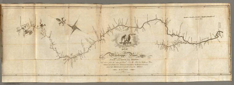
Pike, Zebulon Montgomery
Full Title
Map of the Mississippi River from its Source to the Mouth of the Missouri: Laid down from the notes of Lieut. Z.M. Pike by Anthony Nau. Reduced and corrected by the Astronomical Observations of Mr. Thompson at its source; and of Captn. M. Lewis, where it receives the waters of the Missouri. By Nichs. King. Engraved by Francis Shallus, Philadelphia.
List No
0730.006
Note
The Mississippi River with its tributaries, giving latitude and longitude markings along the way. Uncolored.
Author
Melish, John
Full Title
(Title Page to) Travels in the United States of America, in the years 1806 & 1807, and 1809, 1810 & 1811 ... Illustrated by eight maps. By John Melish. In two volumes. Philadelphia, printed for the author, and for sale by the different booksellers in the United States, and by Thomas & George Palmer, agents for the author. 1812. T. & G. Palmer, printers.
List No
2341A
Note
1st edition. The U.S. map is Tanner's first map (Ristow). Tanner's name is listed on the U.S. map in this first edition, but it is removed in the second edition. All the large maps are uncolored and differ from the second edition large maps in some details, but the small maps are similar in both editions. Uncut. Bound into two half leather books.
Author
Melish, John
Full Title
Map of the United States of America. J. Melish del. H.S. Tanner Sc.
List No
2341.001
Note
Uncolored map showing boundary lines, proposed canals, and Melish's route.
Author
Melish, John
Full Title
Falls of Ohio.
List No
2341.004
Note
Map of the Falls of the Ohio River including the proposed canal. Uncolored.
Author
Melish, John
Full Title
Ohio. Drawn by J. Melish. J. Vallance sc.
List No
2341.006
Note
Map without color showing the townships drawn throughout much of the state.
Author
[Birkbeck, Morris, Melish, John]
Full Title
(Title Page to) Letters From Illinois By Morris Birkbeck ... Illustrated by a Map of the United States, Shewing Mr. Birkbeck's Journey From Norfolk To Illinois And a Map of English Prairie and the Adjacent Country, by John Melish. Philadelphia: Published By M. Carey & Son, 126, Chestnut Street. 1818.
List No
2666A
Note
1st edition with ads for "the Olive Branch." The map of the United States is from Carey's Juvenile Atlas and the Universal School Atlas, with the author's route drawn in. The English Prairie map was done only for this book, I believe, and does not appear elsewhere. The original boards are bound into this later binding.
Author
[Birkbeck, Morris, Melish, John]
Full Title
United States. Published 1st June 1816 by J. Melish. Philadelphia. Improved to 1818.
List No
2666.001
Note
An uncolored map with one pink line. The states and territories are numbered with a reference list included on the map.
|