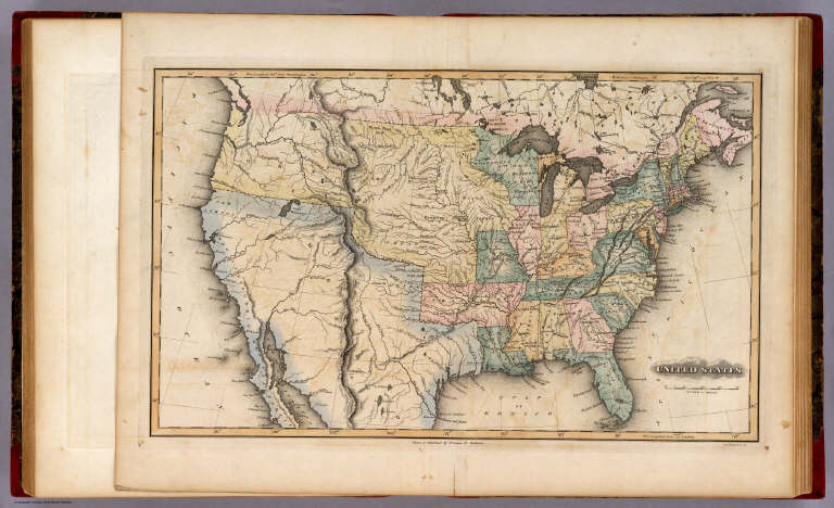
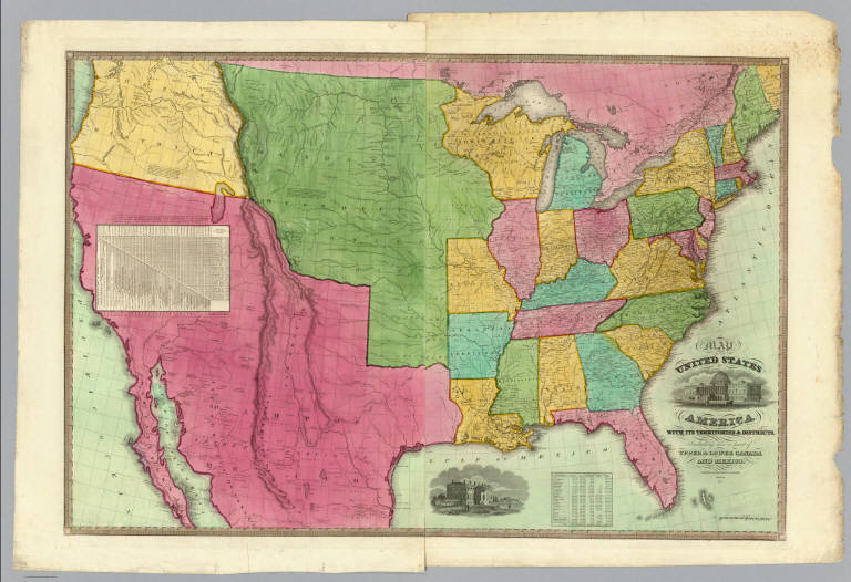
Author
Lucas, Fielding Jr.
Full Title
United States. B.T. Welch & Co. Sc. Drawn & Published by F. Lucas Jr. Baltimore.
List No
4584.045
Note
Full color by state and region.
Author
Mitchell, Samuel Augustus
Full Title
Map Of North America Including All The Recent Geographical Discoveries. Published by S. Augustus Mitchell Philadelphia. 1831. J.H. Young Sc.
List No
3884.001
Note
Full color by country.
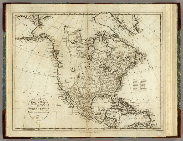
Author
[Reid, John, Winterbotham, W.]
Full Title
A General Map Of North America. Drawn From The Best Surveys 1795. Scoles, sc. Published by Smith, Reid & Wayland.
List No
0845.001
Note
Uncolored.
Goddard, George H. (George Henry), 1817-... Britton & Rey's Map Of The State Of Cali... 1857 2901.000 Related Author
Goddard, George H. (George Henry), 1817-1906
Full Title
Britton & Rey's Map Of The State Of California. Compiled from the U.S. Land & Coast Surveys, the several Military, Scientific & Rail Road Explorations, the State & County Boundary Surveys made under the Order of the Surveyor General of California, & from Private Surveys. By George H. Goddard, C.E. Completed with Additions & Corrections up to the day of publication from the U.S. Land Office & other reliable sources. Lithy. Of Britton & Rey, Montgomery St. Cor. Commercial, S.F. Entered ... 1857 by Britton & Rey ... California. Engraved by H. Steinegger.
List No
2901.000
Note
1st edition. Wheat: "This map, a beautiful example of the cartographer's art, is unfortunately rare and little-known...it was by far the most accurate and complete map of California and of its gold regions which had as yet been published." This copy was issued as a wall map, but it has been nicely restored, varnish removed, rebacked on paper without the rollers. The other examples I am aware of were all pocket maps. See Shumate essay on Goddard. A second edition, reduced in size, was published in 1858, and a third edition was published in 1860 (see WH copies). Map is unvarnished and without rollers. Outline color by county with a full color wash.
Author
Goodwin, F.A.
Full Title
Map Of California And The Adjacent Country. Compiled by F. Goodwin From the best Authors and actual Observation. Entered ... 1855 by F. Goodwin ... New York. Lith. of Geo. E. Leefe, 223 Fulton St. N.Y. (with 8 page description) A Brief Description of California, From The Time of Its First Occupation by the United States and Subsequent Growth ... Accompanied by a Map of California and adjacent Country.
List No
3438.001
Note
Wheat calls this "rare but otherwise unimportant," due to some misspellings and inaccuracies in the map. Streeter sale illustrates the map and the price realized was the same as the Eddy map of 1853. I find the Wheat inaccuracies minor, with most of them being misspellings. The overall map is impressive. It would be interesting to find the map or maps that were used as sources. Ouline color by state. Folded into dark brown cloth covers 16.5x11 with "Map Of California And Adjacent Country By F. Goodwin" stamped in gilt.
Author
[Doolittle, A.J., Holt, A.J., Ransom, Leander]
Full Title
(Covers to) New Map Of The State Of California And Nevada Territory Exhibiting the Rivers, Lakes, Bays and Islands, with the principal Towns, Roads, Railroads and Transit Routes to the Silver Mining Districts of Nevada Territory ... Carefully compiled from United States and other Reliable Surveys by Leander Ransom. A.J. Doolittle, 1863. ... Entered ... 1863 by Warren Holt ... California. Lith. by L. Nagel, 529 Clay St. San Francisco.
List No
4393A
Doolittle, A.J. ; Holt, A.J.; Ransom, Le... New Map Of The State Of California And N... 1863 4393.001 Related Author
[Doolittle, A.J., Holt, A.J., Ransom, Leander]
Full Title
New Map Of The State Of California And Nevada Territory Exhibiting the Rivers, Lakes, Bays and Islands, with the principal Towns, Roads, Railroads and Transit Routes to the Silver Mining Districts of Nevada Territory ... Carefully compiled from United States and other Reliable Surveys by Leander Ransom. A.J. Doolittle, 1863. ... Entered ... 1863 by Warren Holt ... California. Lith. by L. Nagel, 529 Clay St. San Francisco.
List No
4393.001
Note
There are several editions of this map: The first appears in 1862 (Wheat 1046 - "notably rare") under the title of "New Map of the State of California Exhibiting..." and copyrighted in 1861. The Nevada-Utah border in on the 116th meridian. Then in 1863, another issue appears with the same title, but dated 1863 and copyrighted in 1862. A table of distances is added above the title, and the Nevada-Utah boundary is still on the 116th meridian (Wheat 1070). The next issue is still 1863, same title, but the copyright 1863 (Streeter 2880). Then another 1863 issue with the title as above, but with "A" before "New Map..." and Nagel's name dropped (Wheat 1071 - illustrated p. 77). This issue is discussed at length by Wheat and is called "a Nevada map of first importance." There are many additions in Nevada from the prior issues - Wheat delineates them. Our copy is a variant of Wheat 1071 - there is no "A" in the title, Nagel's name is shown, and there are several erasures of town names and one mining district - Agusta Dist (just below the "V" and "A" of Nevada) had been erased as well. The Humboldt River has also been changed. It is not clear if our issue is earlier or later than the Wheat 1071. In stamped red cloth covers 16x11 with an ad for Maps, etc. on the inside cover, Adrien Gensoul's name pasted over Holt's name. Front cover stamped with "Map Of California And Nevada" in gilt. With four pages of routes and distances. This is a superb map, full of interesting and exotic information in Nevada and California. Scale (ca. 1:1,750,000) not 24 miles to an in. as stated on map.
Author
Brue, Adrien Hubert, 1786-1832
Full Title
Nouvelle Carte du Mexique, Et D'Une Partie Des Provinces Unies De L'Amerique Centrale. Dediee a l'Academie Royale des Sciences de l Institut de France. Par A.H. Brue, Geographe du Roi, Membre de la common. centrale de la societe de Geographie de Paris, membre-honoraire de celle de Londres, &a. Revue et augmentee par Ch. Picquet, Geographe du Roi et du Due d'Orleans, Proprietaire des Cartes et Atlas de Brue, Quai Conti No. 17, pres de l'Institut. Paris, 1839. Publiee en 1834; Revue en 1837, 1839 ... (with 2 inset maps).
List No
5386.001
Note
This is the fourth edition of the 1834 Brue map showing Jedidiah Smith's routes in the west. Although Picquet says this 1839 edition is augmented from the 1834, I can find no changes between the two. Wheat calls the 1834 edition "one of the foundation stones of western mapping history." Jedidiah Smith's geography in the Great Basin and California is shown, based on a letter of Smith describing his journeys published in the Nouvelles Annales de Voyages, Paris 1828 (Wheat). Two insets show the environs of Mexico City and Vera Cruz, and the Yucatan. Texas is still shown as a part of Mexico. Under the title Picquet has added his name as publisher; Picquet acquired all Brue's maps from his widow in 1835. There was a second edition in 1835, and a third in 1837. Wheat does not mention this fourth edition. Map is hand painted in outline color, dissected into 21 sections and mounted on linen. Map folds into loose marbled paper wrappers and then into a marbled paper covered slip case with a red label stamped with "Mexique" in gilt.
Cruchley, G.; Laurie, Richard Holmes Fredonia Or The United States of North A... 1833 3827.001 Related Author
[Cruchley, G., Laurie, Richard Holmes]
Full Title
Fredonia Or The United States of North America; Including Also Cabotia, Or The Canadian Provinces; The Western Territory To The Pacific Ocean; And the Northern Part of the Mexican States. 14th August, 1830. Additions 1833.
List No
3827.001
Note
The third edition (although I can detect no changes from the first issue of 1830). Has the note in the lower left explaining the origin of the term of Fredonia. This map is the only one I have seen that copies almost literally three earlier maps: Lewis and Clark (1814), Long (1822), and Arrowsmith's Mexico (1820). Laurie used the term Fredonia, we may assume, to create a novelty of his map, in the same manner as his "Cabotia" map of 1814. Has the original case with label, and an advertisement for Crunchley's publications on the verso of the map. W. Heckrotte has another edition dated 1834 improved to 1836 (with changes in California based on John Arrowsmith's Map of British North America, 1834), and the second edition of 1832. The western topography is changed to incorporate Arrowsmith's map of 1834 (British North America) and an independent Texas is shown. Editions seen of 1830, 1832, 1834, 1836, 1849. It appears that the map was updated frequently in order to keep it current. It is an excellent and beautiful map.
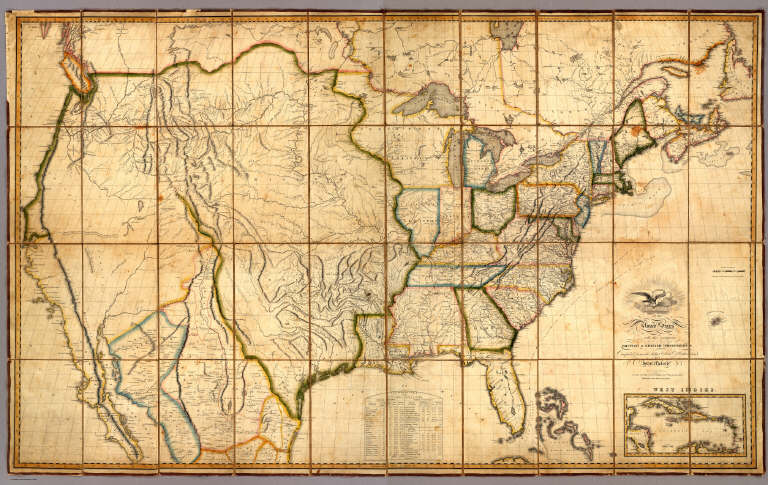
Author
Melish, John
Full Title
Map of the United States with the contiguous British & Spanish Possessions Compiled from the latest & best Authorities By John Melish. Engraved by J. Vallance & H.S. Tanner. Entered ... 6th day of June 1816. Published by John Melish Philadelphia. (inset) West Indies.
List No
5168.001
Note
With insets of the West Indies and a Statistical Table. This map has the distinction of being the first large scale detailed map made in the U.S. that showed the entire country from the Atlantic to the Pacific. This copy is an early state of the first edition -this is Martin's third state of the first edition and Ristow's fourth state (Ristow discovered a town and trail added in Ohio - Adelphi - making for a sub state of Martin's third state). The first state was an incomplete proof copy, making this the second/third state of the completed copy. The differences between this and the first complete state are small: Mansfield, Wooster, and Adelphi (and a trail from Adelphi to Athens and Chillicothe) added in Ohio, and "Vevay or" added before "Swiss Vineyards" in southeastern Indiana. Martin and Ristow identify seven states of the 1816 edition. Melish published new editions in 1818 (five states), 1819 (two states), 1820 (eight states), 1822 (two states), and 1823 (one state) for a total of twenty five different issues. Notwithstanding the many issues, the map has become extremely rare. A book accompanied the map (though issued separately) titled "A Geographical Description of the United States..." (see our #2424). Outline color by state or territory. This copy is dissected into 40 sections, backed with linen, and edged in brown cloth. It folds with marbled end sheets into new blue cloth folding boards and slip case 24.5x16.5 with leather label on spine reading "Melish. Map Of The United States. 1816" in gold.
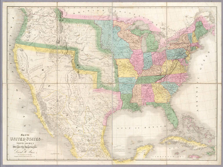
Author
Mitchell, Samuel Augustus
Full Title
(Covers to) A New Map of Texas Oregon and California With The Regions Adjoining. Compiled from the most recent authorities. Philadelphia Published by S. Augustus Mitchell N.E. Corner Of Market & Seventh Streets. 1846. Entered ... 1845 by H.N. Burroughs ... Pennsylvania.
List No
0534A
Author
Mitchell, Samuel Augustus
Full Title
A New Map of Texas Oregon and California With The Regions Adjoining. Compiled from the most recent authorities. Philadelphia Published by S. Augustus Mitchell N.E. Corner Of Market & Seventh Streets. 1846. Entered ... 1845 by H.N. Burroughs ... Pennsylvania.
List No
0534.001
Note
With 46 page "Accompaniment to Mitchell's New Map Of Texas, Oregon, and California With The Regions Adjoining;" the full color map is folded into stamped black leather covers 13.5x8 with "Texas, Oregon And California" in gilt. This was one of Mitchell's most popular and important pocket maps. Later editions were published in 1849, 1851, and 1852, as pocket maps and as insets to the large Reference and Distance Map of the United States. It was also issued separately as a wall map. This issue has Texas colored green; some copies have Texas colored brown (has the green changed over time?). The text has a catalogue for Mitchell's publications. Mitchell first issued this map as an inset to his Reference and Distance Map of the United States in the 1846 edition (see our copy).
Author
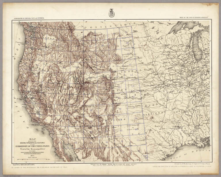
Wheeler, G.M.
Full Title
Map Showing The General Topographical Features Of The Territory Of The United States West of the Mississippi River To Accompany Atlas Of Geographical Explorations And Surveys, West Of The One Hundredth Meridian. 1874. West Of the One-Hundredth Meridian. Seasons of 1869, 1871, 1872 & 1873. 1st. Lieut. Geo. M. Wheeler, Corps of Engineers, U.S. Army in Charge. Geographical Explorations And Surveys.
List No
2738.002
Note
Index map with outline of included maps by numbers in blue. Note center bottom states: "Reduced from the Western Territory Map as a basis with certain additions. When revised and corrected to date it will appear as a sheet of the Topographical Atlas." Topography in crayon. Light brown tint.
Author
Wheeler, G.M.
Full Title
Parts Of N.E. California, N.W. Nevada And Southern Oregon. Atlas Sheet No. 38 B. Issued June 30th, 1882. Weyss, Rock and Karl, Del. Expeditions of 1877 & 1878 Under the Command of 1st Lieut. Geo. M. Wheeler, Corps of Engineers, U.S. Army. U.S. Geographical Surveys West Of The 100th Meridian.
List No
2738.016
Note
In hachures with a light cream under-tint. Topographical Assistants included: J.C. Spiller 1877, Anton Karl 1878, and C.P. Kahler 1878.
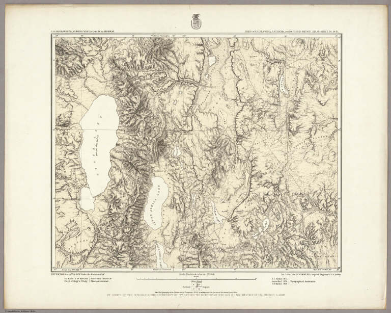
Author
Wheeler, G.M.
Full Title
Parts Of Eastern California And Western Nevada, Atlas Sheet 47(D). Issued June 30, 1882. Weyss, Lang and Herman, Del. Expeditions of 1876 and 1877 Under the Command of 1st. Lieut. Geo. M. Wheeler, Corps of Engineers, U.S. Army. Executive Officers and Field Astronomers: 1st. Lieut. S.E. Tillman, Corps of Engineers, U.S. Army; 2nd Lieuts. T.W. Symons, Corps of Engineers, U.S. Army and M.M. Macomb, 4th Artillery, U.S. Army. Topographical Assistants: Gilbert Thompson, Anton Karl, Frank Carpenter, W.A. Cowles. U.S. Geographical Surveys West Of The 100th Meridian.
List No
2738.029
Note
In hachures with under-tint.
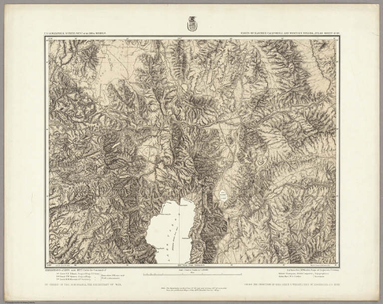
Author
Wheeler, G.M.
Full Title
Part Of Western Nevada, Atlas Sheets No. 48(C). Issued Apr. 29th 1882. Weyss, Spiller & Rock, Del. Expedition of 1876 Under the Command of 1st. Lieut. Geo. M. Wheeler, Corps of Engineers, U.S. Army. Executive Officer and Field Astronomer: 1st. Lieut. Rogers Birnie, 13th U.S. Infantry. Topographical Assistants: J.C. Spiller and W.A. Cowles. U.S. Geographical Surveys West Of The 100th Meridian.
List No
2738.030
Note
In hachures with a light under-tint.
Author
Wheeler, G.M.
Full Title
Map showing Detailed Topography Of The Country Traversed by the Reconnaissance Expedition through Southern & Southeastern Nevada in charge of Lieut. Geo. M. Wheeler U.S. Engineers. Assisted by Lieut. O.W. Lockwood Corps Of Engineers U.S.A. 1869. P.W. Hamel Chief Topographer And Draughtsman. Photolith. by the N.Y. Lithg. Engrg. & Prtg. Co. 16 & 18 Park Place.
List No
2739.000
Note
1st Wheeler map, done before 100th Mer. Survey. Streeter: "Since Wheeler's exploration was in part over country never before mapped, this as far as I know, is the foundation map for southern Nevada." Above the neat line reads "Reconnaissance Maps. Department Of California." Unfolded separate issue. Outline color by county.
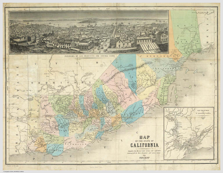
Author
Vincent
Full Title
Map Of The State Of California. Compiled from the most recent surveys and explorations Containing all the latest discoveries and newest towns. By Vincent. Printed by Mangeon S. Jacques St. Engraved by Ch. Smith. (inset) San Francisco and its surrounding localities. 1860.
List No
1124.000
Note
Unusual map showing California on its side with north to the left, an inset map and a beautiful view titled "Panorama Of San Francisco and Contra Costa." Full color by county.
Author
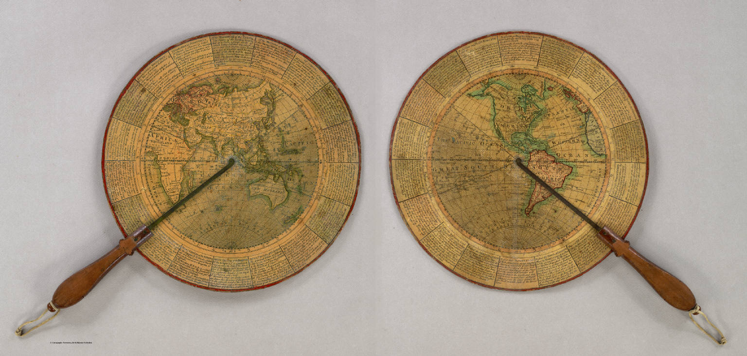
Anonymous
Full Title
(Untitled Geographical/Astronomical Wheel).
List No
4213.000
Note
Untitled, unauthored and undated varnished card wheel 11 3/4" in diameter, printed on both sides with hand colored highlighting, and mounted with a mahogany handle with brass alidades divided 0-90 degrees. Both terrestrial hemispheres are shown, with political, geographic and astronomical features in great detail. The circumference carries numerous definitions and instructions for use and calculation e.g. "To find the Azimuth of ye Sun at any given hour of the Day; To find the Space of Time during which there is no Dark Night; etc." A wonderful, most rare device.
Author
Cushee, Richard
Full Title
A New Globe of the Earth by R. Cushee 1731.
List No
3992.000
Note
Scarce 3 inch diameter pocket globe in black fishskin case lined with colored celestial gores. California is shown as an island, and eastern Australia is not mapped. A very early example of a pocket globe.
Author
Tanner, Henry S.
Full Title
North America. Entered ... 1836 by H.S. Tanner ... Pennsylvania. Philadelphia: Published by H.S. Tanner. (above neat line) Tanner's Universal Atlas.
List No
0977.002
Note
In full color by state or region.
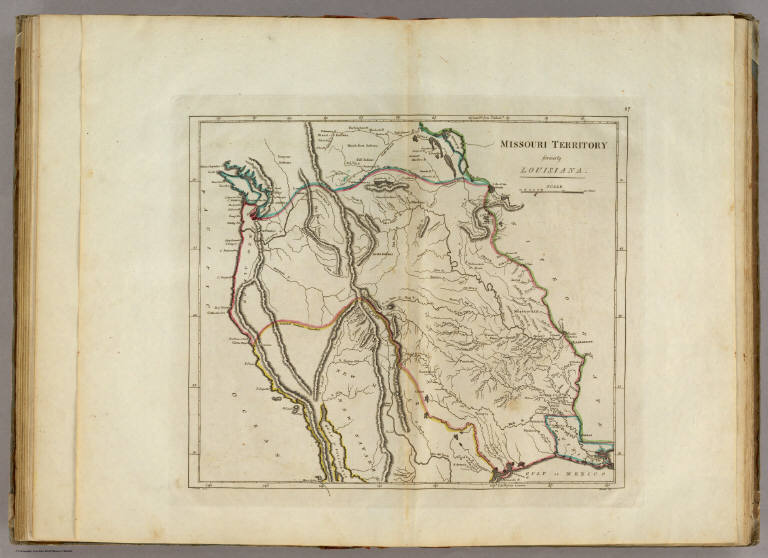
Author
Carey, Mathew
Full Title
Missouri Territory formerly Louisiana. Bower, Sc.
List No
4577.027
Note
Territory shown in outline color from Louisiana in the south to Lake Winnepeg in the north and the Pacific Ocean in the west.
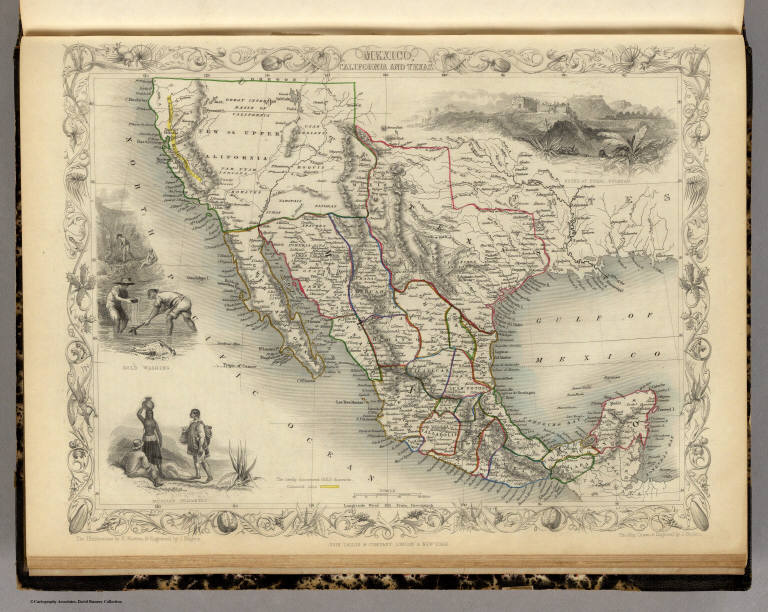
Author
[Martin, R.M., Tallis, J. & F.]
Full Title
Mexico, California and Texas. The Illustrations by H. Warren & Engraved by J. Rogers. The Map Drawn & Engraved by J. Rapkin.
List No
0466.072
Note
Mexico in outline color by county. New or Upper California and Texas shown in outline color. California's "newly discovered GOLD districts" are highlighted in bright yellow following the paths of the R. Sacramento and the Rio San Joaquin. The accompanying illustrations include gold washing, Mexican peasants and the ruins of Uxmal, Yucatan. The decorative border includes vegetation, fruits and vegetables from the region.
Author
Holdredge, Sterling M.
Full Title
Map of the State of Nevada for Guide Book of the Pacific.
List No
2544.004
Note
State in outline color. Numerous exploration trails noted.
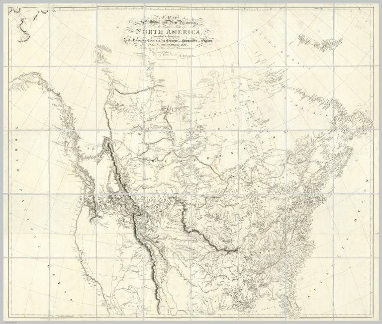
Author
Arrowsmith, Aaron
Full Title
A Map Exhibiting all the New Discoveries in the Interior Parts of North America Inscribed by Permission To the Honorable Governor And Company Of Adventurers Of England Trading Into Hudson Bay In testimony of their liberal Communications To their most Obedient and very Humble Servant, A. Arrowsmith, Hydrographer to H.R.H. the Prince of Wales. No. 10 Soho Square, January 1st 1795. Additions to 1811. Additions to 1814. London: Published Jan. 1, 1795 by A. Arrowsmith No. 10 Soho Square. Additions to 1802 ...
List No
0032.001
Note
This issue incorporates the Lewis and Clark discoveries (and other discoveries) and remaps the entire continent west of the Mississippi. The changes between this and the last edition (1811) are monumental. This copy is from the collection of Sir Charles Broke (or Brooke, subsequently Vere). Broke was in Lower Canada with his regiment, the 5th (Northumberland) Regiment of Foot, which was at the battle of Plattsburg in 1814. Later, he was with the Army of Occupation in France, receiving the Waterloo medal despite arriving from Canada too late for the battle (from Manasek). Without color. Dissected into 40 sections and mounted on linen. Folds into a new gray cloth covered box case 29x22x7 with "North America A. Arrowsmith 1814" stamped on the spine in gold.
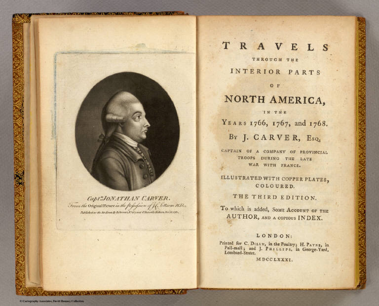
Author
Carver, Jonathan
Full Title
(Title Page to)Travels Through The Interior Parts Of North America, In The Years 1766, 1767, And 1768. By J. Carver, Esq. Captain Of A Company Of Provincial Troops During The Late War With France. Illustrated With Copper Plates, Coloured. The Third Edition. To which is added, Some Account Of The Author, And A Copious Index. London: Printed for C. Dilly, in the Poultry; H. Payne, in Pall-mall; and J. Phillips, in George-Yard, Lombard-Street. MDCCLXXXI. (with 2 maps).
List No
0131A
Note
3rd and best edition. With two important maps: A New Map of North America, From the Latest Discoveries 1778 (shows the proposed eleven numbered territories west of Pennsylvania) and A Plan of Captain Carver's Travels in the interior Parts of North America in 1766 and 1767.
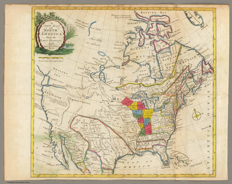
Author
Carver, Jonathan
Full Title
A New Map of North America, From the Latest Discoveries. 1778. Engrav'd for Carvers Travels.
List No
0131.001
Note
Map in color with the majority in outline color and the Midwest in full color. Stretches to Baffin Bay in the north.
Author
[Arrowsmith, Aaron, Humboldt, Alexander von, 1769-1859]
Full Title
A New Map of Mexico and Adjacent Provinces Compiled from Original Documents by A. Arrowsmith. 1810. London. Published 5th October 1810 by A. Arrowsmith, 10 Soho Sque. Hydrographer to H.R.H. the Prince of Wales. Engraved by E. Jones. (with) three inset maps: Valley of Mexico, from Mr. Humboldt's Map; Veracruz; and Acapulco.
List No
2035.001
Note
Map in outline color.
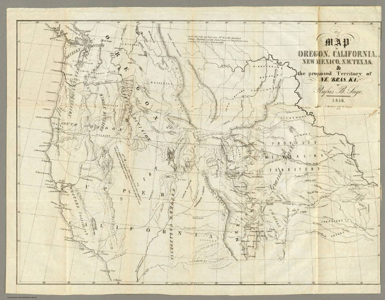
Author
Sage, Rufus B.
Full Title
(Title Page to) Scenes in the Rocky Mountains, and in Oregon, California, New Mexico, Texas, and the Grand Prairies; or Notes by the Way, During An Excursion Of Three Years, with a Description of the Countries Passed Through, including their Geography, Geology, Resources, Present Condition, and The Different Nations Inhabiting Them. By A New Englander. Philadelphia: Published By Carey & Hart. 1846. (on verso) Entered ... 1846, by Rufus B. Sage ... New-York.
List No
2299A
Note
1st edition with the rare map. Map title: "Map of Oregon, California, New Mexico, N.W. Texas, & the proposed Territory of Ne Bras Ka. By Rufus B. Sage. 1846. F. Michelin's Lith. 111, Nassau St. N.Y." Map bound into front of book 19x13 with brown cloth covered boards and "Scenes in the Rocky Mountains California and Texas" engraved on spine.
Author
Sage, Rufus B.
Full Title
Map of Oregon, California, New Mexico, N.W. Texas & the proposed Territory of Ne-Bras-Ka. By Rufus B. Sage. 1846. F. Michelin's Lith. 111 Nassau St. N.Y.
List No
2299.001
Note
Map uncolored. Note in the area of present-day Nevada and Utah states, "This region has never been explored, and is supposed to be impassable on account of its immense plains of sand, alike destitute of vegetation and water."
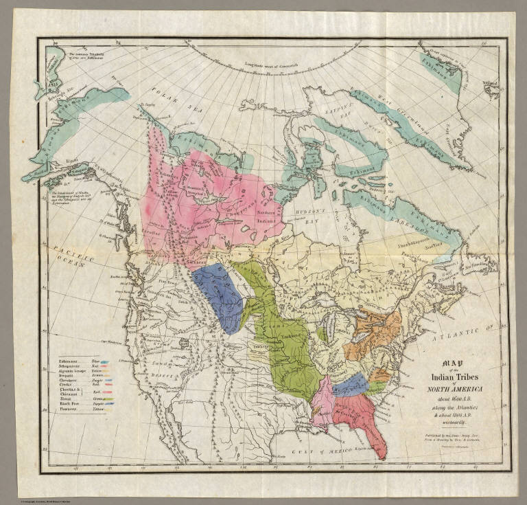
Author
Gallatin, Albert
Full Title
Map of the Indian Tribes of North America about 1600 A.D. along the Atlantic; & about 1800 A.D. westwardly. Published by the Amer: Antiq: Soc: From a drawing by Hon: A. Gallatin.
List No
3388.001
Note
Map in color by tribe. Map extends from Alaska and Baffin's Bay in the north to Florida in the south. Accompanied by a color-coded key.
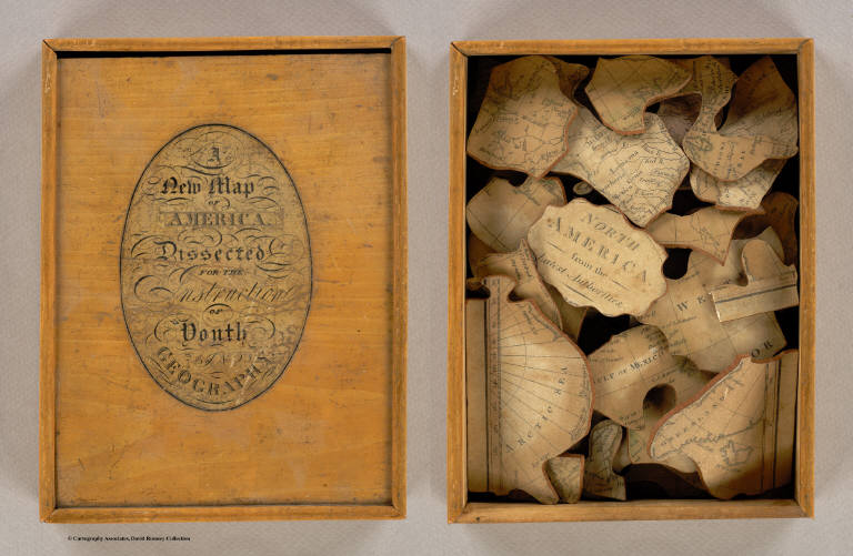
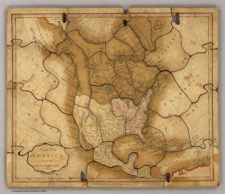
Author
Darton, William
Full Title
(Covers to) A New Map of America, Dissected for the Instruction of Youth in Geography. (with) North America, from the Latest Authorities. Engraved by Willm. Darton. No. 58, Holborn Hill. Published Jany. 26, 1814 by Willm. Darton, London.
List No
3407A
Author
Darton, William
Full Title
North America, from the Latest Authorities. Engraved by Willm. Darton. No. 58, Holborn Hill. Published Jany. 26, 1814 by Willm. Darton, London.
List No
3407.001
Note
Very early map puzzle. The map is from Darton's Union Atlas (see our copy, #4767). Map has some color and has obviously faded with some small sections missing from a few pieces.
Collot, George Henri Victor ; Tardieu, P... Map of the Missouri; of the higher parts... 1796 4664.019 Related Author
[Collot, George Henri Victor, Tardieu, P.F.]
Full Title
Map of the Missouri; of the higher parts of the Mississippi; and of the elevated Plain, where the Waters divide, which run, Eastward into the River St. Lawrence; North East into Hudson's Bay; North North West into the Frozen Sea; and South into the Gulf of Mexico. To which is added Mackenzie's track in 1789. PL. 29.
List No
4664.019
Note
This was the first map to show the results of the expedition of J.B. Trudeau from 1794 to 1796. It is also one of the most important late Eighteenth Century maps showing the Transmississippi West and is highly praised (and illustrated) by Wheat: "an important intermediate cartographic step between Soulard's highly rudimentary showing of the Missouri Basin, and the excellent charts of the river as far as the Mandan Villages drawn by McKay and Evans."
Author
Thompson, Thos. H.
Full Title
Map of the States of California and Nevada Carefully Compiled From Actual Surveys, Personal examinations and information furnished by the County Surveyors of the State expressly for this Work. Published by Thompson & West. 120 Sutter St. San Francisco. (with) inset map of San Bernardino and San Diego Counties.
List No
2205.001
Note
In full color by county.
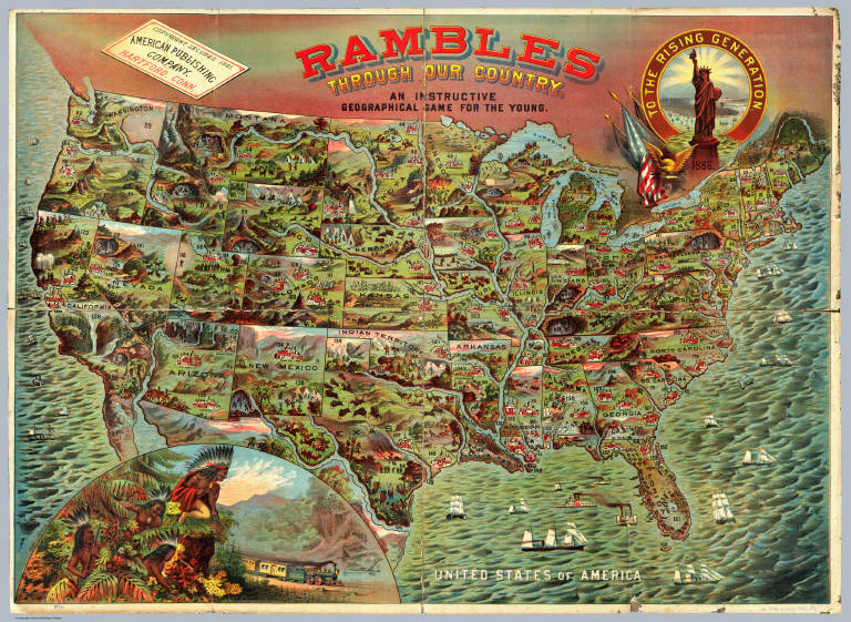
Author
American Publishing Company
Full Title
Rambles Through Our Country. An Instructive Geographical Game For The Young. Copyright Secured 1881. American Publishing Company. Hartford, Conn. 1886.
List No
3886.000
Note
This is meant to accompany a board game with a map of the United States (see our #5086). However, it functions as a geography of the U.S. by itself. In full color.
Author
[DeGroot, Henry, Holt, Warren]
Full Title
DeGroot's Map Of Nevada Territory Exhibiting A Portion Of Southern Oregon & Eastern California With County Boundaries, Mining Districts, Railroad Routes, Wagon Roads, Table Of Distances, &c. &c. Published By Warren Holt, 305 Montgomery St. San Francisco, Cal. 1863. Entered ... 1862 by Warren Holt ... California.
List No
3453.000
Note
Very scarce detailed map of the early Nevada Territory. Wheat: "DeGroot's 'Nevada' of 1863 is truly an impressive performance...cartographical pioneering of the first order." Wheat believed that the map may have actually been published in 1862 (the date of its copyright) but dated 1863 to be up to date, because it shows the eastern boundary of Nevada at the 116th meridian instead of the 115th which was made the boundary in July of 1862. Much is shown in Nevada, but also in western California, Southern Oregon (the Owyhee is "unexplored") and a small corner of Washington Territory (now Idaho). According to Wheat, DeGroot had extensive first hand knowledge of the entire area and the map displays this with great clarity. What is unusual about this map is its sense of accuracy - it looks like nothing has been put in that the author was not sure of - much like Arrowsmith's maps of the early 1800's. W.H. has the Howell copy with DeGroot's printed Guide to the map mentioned by Wheat and Wagner Camp; probably the only copy of the map existing with the guide, and the only copy of the guide. Map is in full color by county.
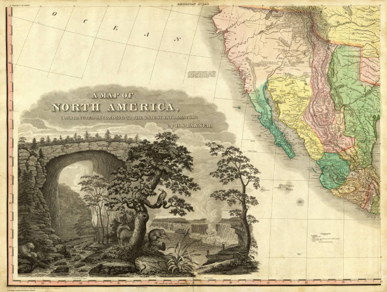
Author
Tanner, Henry S.
Full Title
A Map of North America, Constructed According To The Latest Information: by H.S. Tanner. S.W. Sheet. Entered ... 27th day of May 1822, by H.S. Tanner ... Pennsylvania. Engraved & Published by H.S. Tanner. Philadelphia. 1822. Printed by Wm. Duffee. American Atlas.
List No
5388.011
Note
Third of four sheets comprising the North American map. Scale measured at 10 degrees latitude. In full color. This section contains the title cartouche with an elaborate drawing that includes Natural Bridge in Virginia and the Falls of Niagara. This section includes California and Mexico.
Author
Scott, Bradford
Full Title
North America. Bradford Scott.
List No
3542.001
Note
In outline color.
Author
Arbuckle Bros.
Full Title
Territory of Arizona, Nebraska, Nevada, Arkansas. Copyright 1889 Arbuckle Bros. N.Y.
List No
0027.012
Note
Sheet with maps of four states in full color. The notes about Arizona describe the Grand Canyon ("a deep channel through the rocks, so that for long distances it flows between perpendicular walls 7,000 feet in height") but does not call it such. Nevada is known as the "great silver State of the Union." Each card measures 7.5 x 12.5 cm.
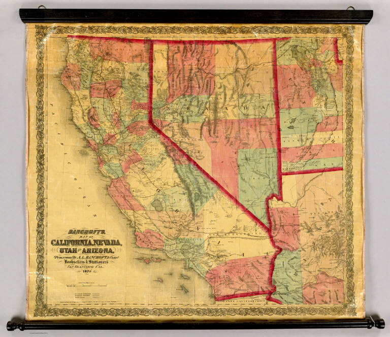
Author
Bancroft, A.L.
Full Title
Bancroft's Map Of California, Nevada, Utah And Arizona. Published By A.L. Bancroft & Compy. Booksellers & Stationers, San Francisco, Cal. 1873. Entered ... by A.L. Bancroft & Company ... Washington, D.C.
List No
0046.000
Note
1st edition was 1864. From Bancroft's Map the of Pacific States which appeared in 1863. Wheat says Bancroft changed the large Pacific States map in 1870, but we believe that the smaller maps such as this continue to be from the original 1863 or 1867 plates, updated to show railroad expansion and topographical changes. With black top and bottom rollers. Full color by county.
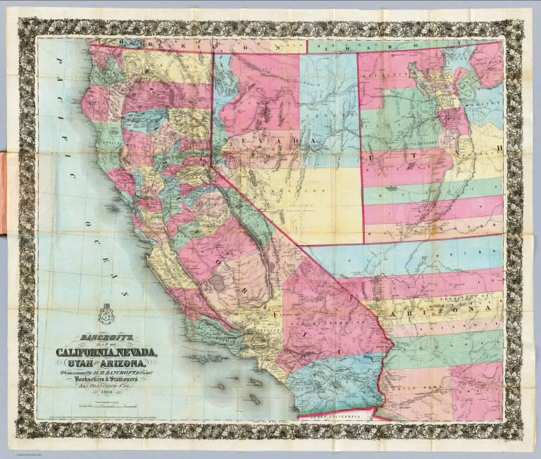
Author
Bancroft, H.H.
Full Title
(Covers to) Bancroft's Map Of California, Nevada, Utah And Arizona. Published By H.H. Bancroft, & Compy. Booksellers & Stationers San Francisco Cal. 1864. Entered ... 1863, by H.H. Bancroft & Company ... California.
List No
4820A
Author
Bancroft, H.H.
Full Title
Bancroft's Map Of California, Nevada, Utah And Arizona. Published By H.H. Bancroft, & Compy. Booksellers & Stationers San Francisco Cal. 1864. Entered ... 1863, by H.H. Bancroft & Company ... California.
List No
4820.001
Note
First edition, second issue of this map with a different border and small changes in the map (see notes to our #4819). Full color by county. Folded into stamped brown cloth covers 16x10.5 with "Bancroft's Map Of California, Nevada, Utah And Arizona." in gilt.
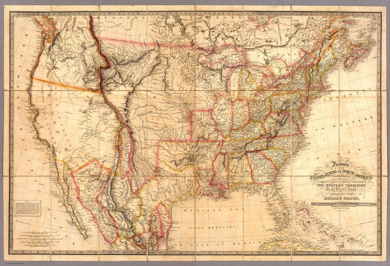
Author
[Barber, B.B., Willard, A.]
Full Title
Map Of The United States Of America With Its Territories & Districts. Including also a part of Upper & Lower Canada And Mexico. Published By B.B. Barber & A. Willard, Hartford, 1835.
List No
2240.000
Note
1st ed. was 1833; later editions by Reed & Barber. An unusual map in two sheets, showing the continent coast to coast. Tanner's influence from his North America map is evident in the west, and Long's map has influenced the plains, but Tanner's U.S. map is the primary source, in the Oregon District, the Plains, and the area east of the Mississippi. The Great Basin is filled with a table of distances and heights of mountains (which convention appears in several maps published in Hartford about this time by Thrall, Huntington, Olney's Geography, etc.). Wheat mentions the 1849 and 1850 editions of this map published by Reed and Barber, but this much earlier and different edition was unknown to him. Not in Phillips. Views of the Capital and the White House. Phelps did a related and somewhat smaller map in 1833 - see our copy. After the 1835 edition, no editions until the 1848 by Reed and Barber (see our 1849, 1850 and 1854 editions). Map is in full color.
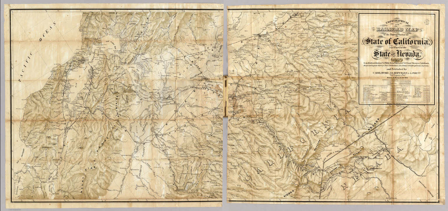
Bielawski, C. ; Hoffman; Hoffmann, J.D. ... Cover: Central part, State of California... 1865 4822A Related Author
[Bielawski, C., Hoffman, Hoffmann, J.D., Poett, A.]
Full Title
(Covers to) Topographical And Railroad Map of the Central Part of the State of California, and Part of the State Of Nevada. 1865. Compiled from Railroad Surveys, U.S. Public Land Surveys, U.S. Coast Surveys, California State Geological Survey (Prof. J.D. Whitney), and from reliable private Surveys, and Published by C. Bielawski, J.D. Hoffmann & A. Poett, Civil Engineers & Survrs. Britton & Co. Lith: San Francisco. Entered ... 1865 by J.D. Hoffmann & A. Poett ... California.
List No
4822A
Bielawski, C. ; Hoffman; Hoffmann, J.D. ... The Central Part of the State of Califor... 1865 4822.001 Related Author
[Bielawski, C., Hoffman, Hoffmann, J.D., Poett, A.]
Full Title
Topographical And Railroad Map of the Central Part of the State of California, and Part of the State Of Nevada. 1865. Compiled from Railroad Surveys, U.S. Public Land Surveys, U.S. Coast Surveys, California State Geological Survey (Prof. J.D. Whitney), and from reliable private Surveys, and Published by C. Bielawski, J.D. Hoffmann & A. Poett, Civil Engineers & Survrs. Britton & Co. Lith: San Francisco. Entered ... 1865 by J.D. Hoffmann & A. Poett ... California.
List No
4822.001
Note
This scarce map shows a large band of central California from San Francisco Bay to Virginia City, Nevada. The showing of railroads is extensive with a separate table listing the engineers for each road. Topography is delineated in "crayon" style resulting in a very clear rendition of the Coast Range and the Sierra Nevada Mountains. The mining camps are shown in great number and the overall detail is most impressive with a 4 miles to 1 inch scale. The Whitney Survey "Map of Central California" of 1873 is the only map that we know of that is comparable, yet it is eight years later, at a scale of 6 miles to 1 inch, and runs from west to east from San Francisco Bay, thus ending at Mono Lake and missing Lake Tahoe. This 1865 map runs from southwest to northeast, covering Lake Tahoe and extending to Pyramid Lake in Nevada. We have not seen any map of central California of this period that has the clarity and detail of this map. The map was copyrighted in 1865 by Hoffmann and Poett, about whom not much is known, except that Hoffmann made a "Topographical Map of Lake Tahoe..." in 1874 with Ferdinand Von Leicht (Graff 4497); it is not clear why Bielawski was not also listed on the copyright - perhaps because he was for many years surveyor for the U.S. General Land Office in San Francisco. Haiman states that Bielawski "was considered the most important person in the Land Office, that he personally surveyed and was generally recognized as the best authority on real property titles in the state." This copy is folded into untitled brown cloth covers stamped with a decorative border.
Author
Burr, David H., 1803-1875
Full Title
Map of the United States Of North America With parts of the Adjacent Countries, By David H. Burr. (Late Topographer to the Post Office.) Geographer to the House of Representatives of the U.S. John Arrowsmith. Entered ... July 10th, 1839, by David H. Burr ... District of Columbia.
List No
0104.001
Note
This is the "Map of the United States of North America..." from Burr's American Atlas which consists of 13 separate sheets dissected & mounted on linen. In full color by state, country, or region. In 8 sections mounted on linen. Label on back states "No. 1. United States."
Author
[Craven, A., Hoffman, Hoffmann, C.F., Leicht, F., Geological Survey of California]
Full Title
State Geological Survey Of California, J.D. Whitney, State Geologist. Map Of California And Nevada. Drawn By F.v. Leicht And A. Craven ... J. Bien, Lith. N.Y. 2nd edition Revised by Hoffmann and Craven and issued by authority of the Regents of the University of California given May 12th 1874.
List No
0115.000
Note
1st edition was 1873. Under the title is the following Note: "In the compilation of this map the following materials were used. For California: The work of the State Geological Survey and that of the U.S. Coast and Land Surveys. For Nevada: The work of the Fortieth Parallel Survey, under Clarence King, the U.S. Engineer Explorations under Williamson and Wheeler; the Central Pacific Railroad Survey under Butler Ives; and the work of the California Survey, by Wackenreuder, Craven, Wilson and Loehr from 1863 to 1872." Full printed color. Map is dissected into 54 sections and mounted on linen. Folds into a tan cloth folding case 19x13 with "California & Nevada California Geological Survey 1874" stamped in gold on the spine.
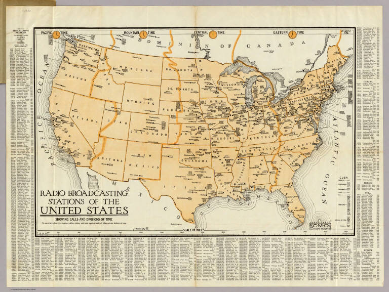
Author
Clason Map Company
Full Title
(Covers to) Radio Broadcasting Stations Of The United States Showing Calls And Divisions Of Time. Copyrighted The C.M. Co. All Rights Reserved.
List No
4775A
Author
Clason Map Company
Full Title
Radio Broadcasting Stations Of The United States Showing Calls And Divisions Of Time. Copyrighted The C.M. Co. All Rights Reserved.
List No
4775.001
Note
The date is estimated. Shows location of radio stations, time zones, and has an index of stations with their "meter lengths" (?). Folded into gray card board covers 16x10 with green and black print; front cover reads "Price 25 Cents Radio Map With Index Of Broadcasting Stations Of United States And Posessions (sic) Canada Mexico Europe. The Clason Map Co. Chicago-Denver." Full color.
|