Author
Duflot de Mofras, Eugene
Full Title
Carte De La Cote De L'Amerique Sur L'Ocean Pacifique Septentrional Le Territoire De L'Oregon, Les Californies, La Mer Vermeille, Partie des Territoires de la Compagnie de la Baie d'Hudson, Et De L'Amerique Russe. Dressee par Mr. Duflot de Mofras, Attache a la Legation de France a Mexico; Pour servir a l'intelligence de son Voyage d'exploration Publie Par Ordre Du Roi, sous les Auspices De Mr. Le Marechal Duc De Dalmatie, Mr. Le Ministre Des Affaires Etrangeres. Paris, 1844. Le plan grave par Jacobs. L'ecriture gravee par Hacq. Publie par Arthus Bertrand.
List No
4119.001
Note
Map in outline color with copious notes throughout California. Mines, ports, Indian settlements, forts, and missions are shown.
Author
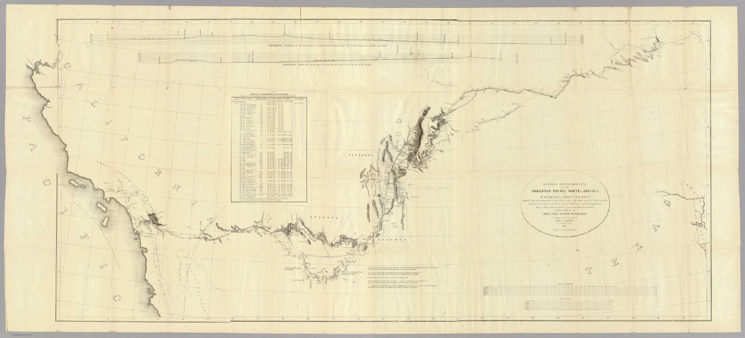
Emory, William H.
Full Title
Military Reconnaissance Of The Arkansas Rio Del Norte And Rio Gila By W.H. Emory, Lieut. Top. Engrs. Assisted ... by J.W. Abert and W.G. Peck, and ... by W.H. Warner and Mr. Norman Bestor, Made in 1846-7, with the advance guard of the "Army of the West". Under Command Of Brig. Gen. Stephn. W. Kearny. Constructed under the orders of Col. J.J. Abert ... 1847. Drawn by Joseph Welch. Engraved on stone by E. Weber & Co. Baltimore.
List No
3639.001
Note
Senate edition. Has the large map, "Map of a Military Reconnaissance of the Arkansas Rio del Norte and Rio Gila..." See separate listing of the map. Book bound with linen covered boards with title on the spine.
Author
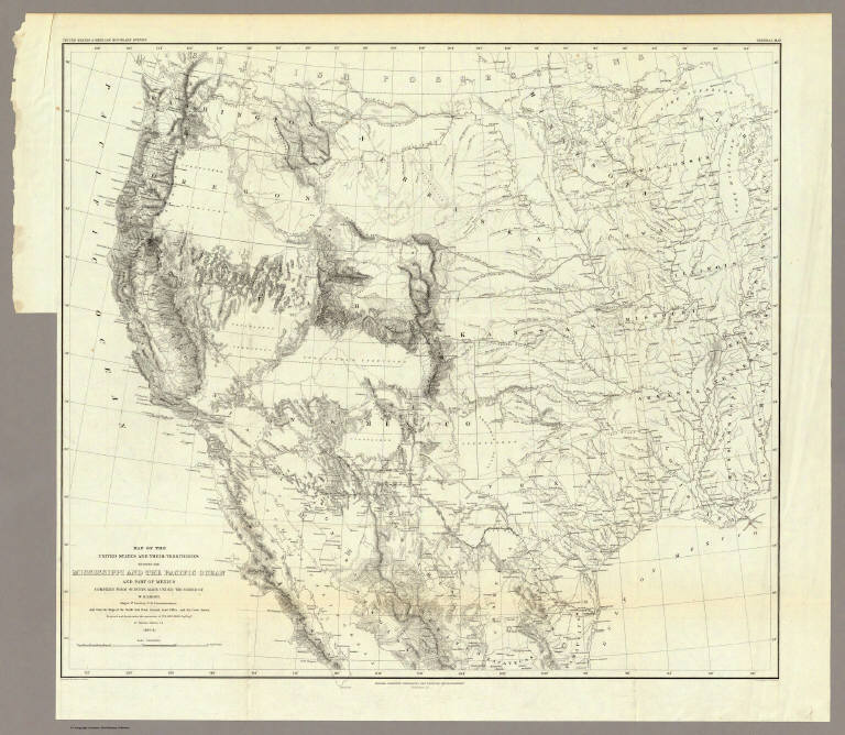
Emory, William H.
Full Title
Map Of The United States And Their Territories Between The Mississippi And The Pacific Ocean And Part Of Mexico Compiled From The Surveys Made Under The Order Of W.H. Emory. ... And from the Maps of the Pacific Rail Road, General Land Office, and the Coast Survey. Projected and drawn under the supervision of Lt. N. Michler, Topl. Engrs. By Thomas Jekyll, C.E. 1857-8. Engraved by Selmar Siebert. Selmar Siebert's Engraving and Printing Establishment. Washington, D.C. Lettering by F. Courtenay. (above map) United States & Mexican Boundary Survey. General Map.
List No
0263.001
Note
Map without color.
Author
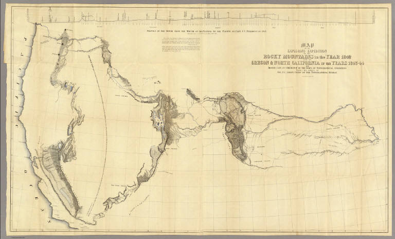
Fremont, J.C.
Full Title
Map Of An Exploring Expedition To The Rocky Mountains in the Year 1842, Oregon & North California In The Years 1843-44. By Brevet Capt. J. C. Fremont Of The Corps Of Topographical Engineers Under the orders of Col. J.J. Abert, Chief Of The Topographical Bureau. Lith. by E. Weber & Co. Baltimore, Md.
List No
1833.001
Note
House Issue; map in case. Lacks the astronomical observations that appear in the first issue by the Senate. The large map of the west is one of the most interesting and beautiful government maps of the 1840's. It filled in many of the gaps in cartographic knowledge of the west. Charles Preuss was the cartographer. Fremont and Preuss mapped only what they saw along their routes, leaving large areas blank. Map is without color. Book is bound with full leather with "Executive Documents 2d Sess. 28th Cong." on the spine in gold.
Author
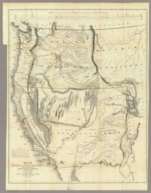
Fremont, J.C.
Full Title
Map Of Oregon And Upper California From the Surveys of John Charles Fremont And other Authorities. Drawn By Charles Preuss Under the Order of the Senate Of The United States, Washington City 1848. Lithy. by E. Weber & Co. Balto. (inset) Profile of the travelling route from the South Pass of the Rocky Mountains to the Bay of San Francisco.
List No
1857.001
Note
The map for the first time filled in the details of the Great Basin. Charles Preuss drew the map. A smaller version of the map appears in President Polk's Message of 1849 (see our copy). Report rebound with cloth covered boards and title on spine.
Author
[Frey, A.C., Nell, Louis]
Full Title
Topographical Railroad & County Map Of The States Of California And Nevada Compiled from the latest explorations and other official information by L. Nell, N.Y. Published by A.C. Frey & Co 204 Fulton St. New York. General Agents for California A. Roman & Co. 417 & 419 Montgomery St. San Francisco. Ferd. Mayer & Co. Lithographers, 96 Fulton St. N.Y. Entered ... 1868 by Frey & Nell ... New York. (inset) Map of the City of San Francisco, California. (inset) Map Of The Great National Pacific Railroads.
List No
3440.000
Note
Wheat writes several pages about this map, being impressed with its up to date cartography. Williamson's proposed route through the Owyhee to the Idaho mines is shown, as well as much current detail in central Nevada and all of California. The influence of Williamson's 1866 "Map of Parts of California, Nevada, Oregon and Idaho Territory" (both the published and the ms version) is obvious. A wheel shows the "Difference of time between S. Francisco and other important Cities." This may be Louis Nell's first commercial map, before his extensive work for the Wheeler Survey in the 1870's and his Colorado maps of the 1880's. The railroad map shows the Union Pacific completed to Cheyenne and the Central Pacific to the Nevada border. This is both a beautiful map and an excellent depiction of California and Nevada just before the completion of the railroad. Wheat mentions that the towns of the Humboldt valley are sprinkled with names that disappear in a few years with the coming of the railroad. Full color by county.
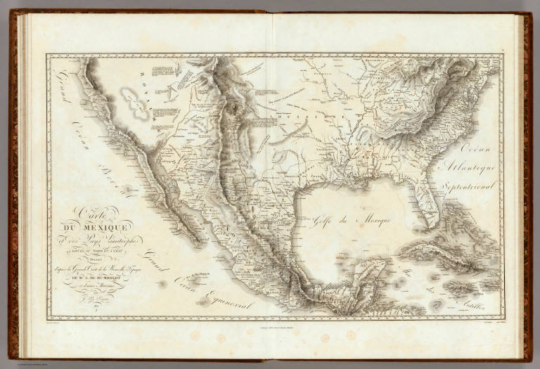
Humboldt, Alexander von, 1769-1859 Carte Du Mexique et des Pays Limitrophes... 1811 0328.004 Related Author
Humboldt, Alexander von, 1769-1859
Full Title
Carte Du Mexique et des Pays Limitrophes Situes Au Nord et a l'est Dressee d'apres la Grande Carte de la Nouvelle Espagne De Mr. A. De Humboldt et d'autres Materiaux par J.B. Poirson. 1811. 2. Grave par Barriere. et l'ecriture par L. Aubert. Se trouve a Paris chez F. Schoell, Libraire.
List No
0328.004
Note
An uncolored map of Mexico, the United States and the West Indies.
Author
Hutawa, Julius
Full Title
(Covers to) Map Of Mexico & California. Compiled from the latest authorities. By Juls. Hutawa. Lithr. Second St. 45 St. Louis, Mo. 2nd Edition. 1863. (inset) Vicinity of Mexico.
List No
0335A
Author
Hutawa, Julius
Full Title
Map Of Mexico & California. Compiled from the latest authorities. By Juls. Hutawa. Lithr. Second St. 45 St. Louis, Mo. 2nd Edition. 1863. (inset) Vicinity of Mexico.
List No
0335.001
Note
Reissue of 1848 2nd edition. Wheat says that only one copy of the map without the "2nd edition" added exists; he doesn't say where; also he says that only one copy exists, at the Bibliotheque Nationale in Paris, with 2nd edition and no date after it (the true 2nd edition of 1848). Wheat's copy is like this one, as is the Huntington Library copy. There are no changes other than colored boundaries and the addition of New Mexico in type, between this and the 1848 edition. Map is folded into yellow card board covers 14x9 printed with "Hutawa's Traveling Map Of Mexico, And California."
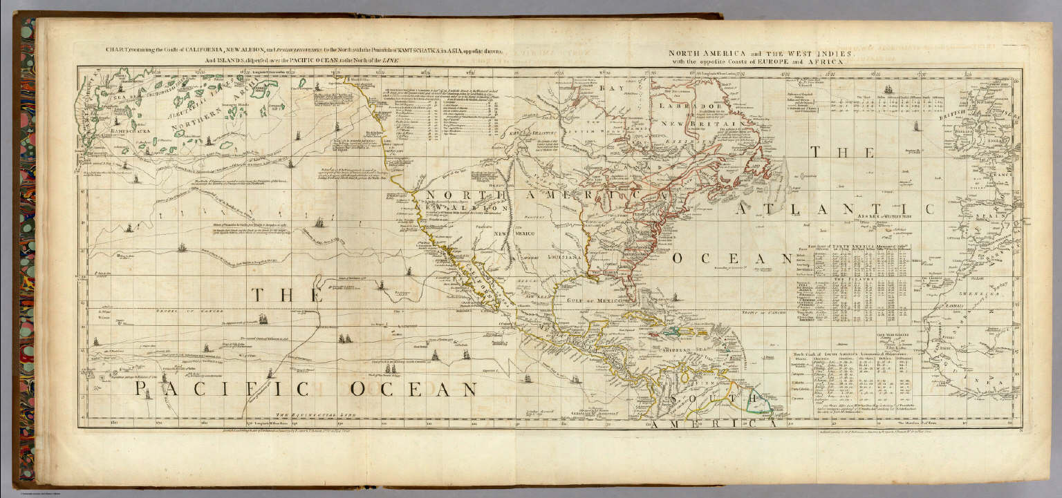
Author
Jefferys, Thomas
Full Title
Chart containing the Coasts of California, New Albion, and Russian Discoveries to the North, with the Peninsula of Kamtschatka, in Asia, opposite thereto; And Islands, dispersed over the Pacific Ocean, to the North of the Line. North America and The West Indies, with the opposite Coasts of Europe and Africa. Published ... 10 June 1775, by R. Sayer & J. Bennett ... Fleet Street. IV.
List No
0346.002
Note
In outline color. Map has extensive notes and charts noting variations in latitudes and longitudes noted by different observations. Tracks of the ships in the Pacific Ocean shown along with relevant dates.
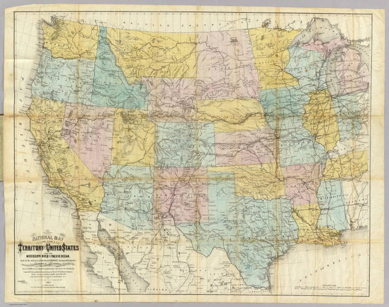
Author
Keeler, William J.
Full Title
National Map Of The Territory Of The United States From The Mississippi River To The Pacific Ocean. Made by the authority of the Hon. O.H. Browning, Secretary of the Interior. ... Compiled from authorized explorations of Pacific Rail Road Routes, Public Surveys, and other reliable data from the Departments of the Government at Washington, D.C. by W.J. Keeler, Civil Engineer. 1868. Entered ... 1867 by Wm. J. Keeler ... Columbia. N. DuBois Draughtsman.
List No
4640.001
Note
This is the reduced issue with slightly more coverage in the east and more progressed railroad development. The detail is, of course, less, due to the smaller scale, and the minerals are not colored in. Nonetheless it is still an excellent map of the west in its time, and is far more scarce than the larger issue of 1867. Full color by state, folded into brown cloth covers 18x11.5 with "Keeler's Map Of The U.S. Territories, Pacific R.R. Routes, Mineral Lands, And Indian Reservations. 1868." stamped in gilt.
Author
King, Clarence
Full Title
(Title Page to) Engineer Department U.S.A. Geological and Topographical Atlas Accompanying the Report of the Geological Exploration of the Fortieth Parallel Made by the Authority of the Honorable Secretary of War under the direction of Brig. and Brvt. Major General A.A. Humphreys, Chief of Engineers U.S.A. by Clarence King, U.S. Geologist in Charge, 1876. Julius Bien Lith.
List No
0408B
Note
Magnificent, huge atlas showing the area of the 40th Parallel Survey in topographical and geological maps. Wheat notes: "These are pioneer survey maps, and as such are most interesting. Mapping the West in so broad a cross-section had never before been attempted, a portent of things to come." King, at the age of 25, was made Geologist-in-charge of the Survey in 1867. He was formally ordered "to examine and describe the geological structure, geographical condition and natural resources of a belt of country extending from the 120th meridian eastward to the 105th meridian, along the 40th parallel of latitude with sufficient expansion north and south to include the lines of 'Central' and 'Union Pacific' railroads..." (Wheat). The topographical sheets depict features by brush shading rather than hachuring. In original binding -rare. Bound in green half leather with a label on the front, "Geological and Topographical Atlas Accompanying the Report of the Geological Exploration of the Fortieth Parallel. Clarence King, Geologist in Charge."
Author
King, Clarence
Full Title
Cordilleras.
List No
0408.001
Note
Map in what came to be known as "plastic shading." The development of halftone lithography made this technique possible. The technique depicts surface features by brush shading rather than the more conventional hachuring. The map is in brown tones with the index maps highlighted in red.
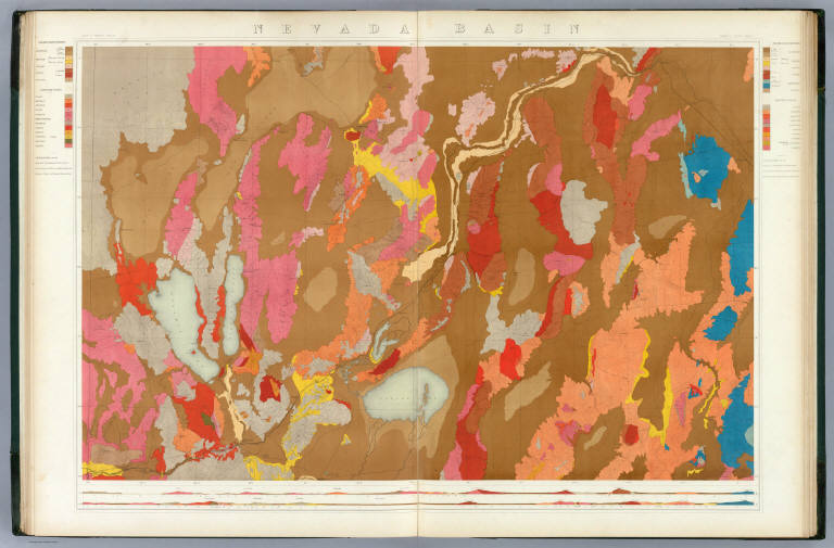
Author
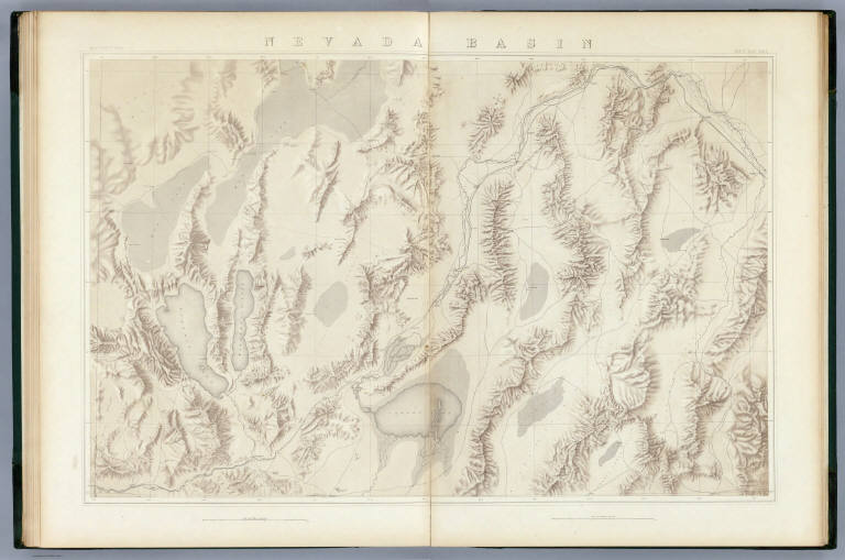
King, Clarence
Full Title
Nevada Basin. Map V. (Geological)
List No
0408.006
Note
Map in full color with the legends on either side of the maps. Map extends from Argenta, Nevada to the west of Pyramid Lake (Lake Tahoe) in California. Below the map are two geologic cross sections.
Author
King, Clarence
Full Title
Nevada Basin. Map V. (Topographical)
List No
0408.013
Note
Map in brown shaded relief. Map extends from Argenta, Nevada to the west of Pyramid Lake (Lake Tahoe) in California.
Author
Rand McNally and Company
Full Title
(Covers to) Rand McNally Junior Road Map California and Nevada. Copyright By Rand McNally & Co. Chicago Ill. Made In U.S.A. ... (1926)
List No
1596A
Author
Rand McNally and Company
Full Title
Rand McNally Junior Road Map California and Nevada. Copyright By Rand McNally & Co. Chicago Ill. Made In U.S.A. .. (1926)
List No
1596.001
Note
These maps formed the basis for the first Rand McNally Auto Road Atlas that appeared in 1924 and 1926. Folded into white card board covers 13x8 printed with "Rand McNally Junior Auto Trails Map. States Of California And Nevada. Presented by H.W. Logan Phone Oak. 679, 401 Webster Street, Oakland, Calif." Also stamped with the ad "Brunswick Tires" in black against orange background. Map is printed in dark blue and roads are shown in red. "H-43."
Author
U.S. General Land Office
Full Title
Department Of The Interior General Land Office J.A. Williamson, Commissioner. State Of Nevada. 1879. Compiled from the official Records of the General Land Office and other sources by C. Roeser, Principal Draughtsman G.L.O. Photo lith & print by Julius Bien 16 & 18 Park Place N.Y.
List No
4620.000
Note
Printed outline color; water in light blue.
Author
U.S. War Department, Chief of Engineers
Full Title
Map Of California And Nevada, With Parts Of Utah & Arizona. Prepared in the Office of the Chief Of Engineers U.S.A. 1879.
List No
3360.000
Note
A larger version of a portion of the Freyhold/Warren U.S. of 1879. Wheat mentions this map in the same paragraph as the Freyhold/Warren map but he does not notice that they are from the same map! Wheat calls this map "certainly a major map of this large area..." Issued on thin paper for field use. Paper is watermarked "Crane Co. 1885." Map is without color.
Author
U.S. War Department, Topographical Engineers
Full Title
Map Of The United States And Their Territories Between The Mississippi and the Pacific Ocean And Of Part of Mexico. Compiled in the Bureau of the Corps of Topogl. Engs. under a Resolution of the U.S. Senate. From the best authorities which could be obtained. 1850. Engraved by Sherman and Smith, New-York.
List No
5142.000
Note
This was the best general map of the American West published by the Topographical Engineers until the Emory and Warren maps of 1857. Wheat calls it "beautiful... a synthesis of the many and varied cartographic activities of the U.S. Army carried on in the West since the onset of the Mexican War, with numerous individual maps subjected to correction and enhanced by new data." A large and imposing production, the map shows the new political divisions of California, Utah and New Mexico and is engraved in the best style by the well known Sherman and Smith firm of New York. Map is without color.
Freyhold, Edward; Warren, Gouverneur Kem... Territory Of The United States From The ... 1868 2919.000 Related Author
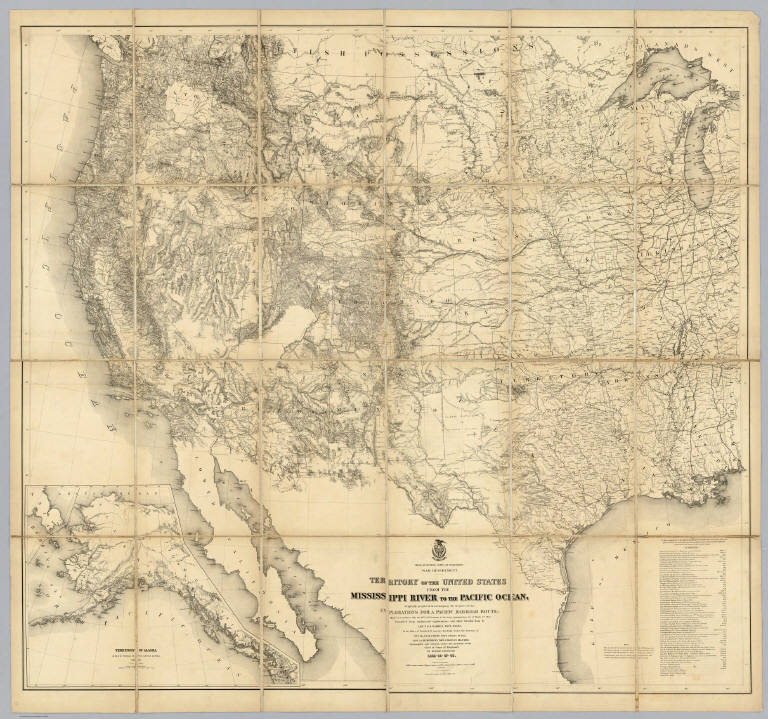
[Freyhold, Edward, Warren, Gouverneur Kemble, 1830-1882]
Full Title
Territory Of The United States From The Mississippi River To The Pacific Ocean; Originally prepared to accompany the Reports of the Explorations For A Pacific Railroad Route ... Compiled from authorized explorations and other reliable data by Lieut. G.K. Warren, Top'l. Eng'rs. In the Office of Pacific R.R. Surveys, War Dept. under the direction of Bvt. Maj. W.H. Emory, Top'l. Eng'rs. in 1854. Capt. A.A. Humphreys, Top'l. Eng'rs. in 1854-58. Recompiled and redrawn under the direction of the Chief of Corps of Engineers By Edward Freyhold 1865-66-67-68. Head Quarters Corp Of Engineers, War Department. Engraved & printed by Julius Bien, N.Y. (inset) Territory Of Alaska Ceded By Russia To The United States 1868.
List No
2919.000
Note
Alaska inset; 59 "authorities"; Streeter copy. Wheat: "one of the great American maps, and one profoundly influential." The final revision of the original Warren map of 1857; largely redrawn, in substance, and style of hachuring. An earlier state of the same imprint is described in Streeter 3080. See Wheeler vol 1 reference. In 1879 Freyhold issued another larger version of this map (Wheat 1295) (see our copy). Without color. Dissected into 24 sections and mounted on linen. Folds into a new burgundy cloth folding case 30x22 with original spine label reading "Freyhold - Map Of Explorations For Pacific R.R. - Recompiled 1865-68."
Author
Bradford, Thomas G.
Full Title
United States. Entered ... 1838, by T.G. Bradford ... Massachusetts.
List No
0089.005
Note
Map in full color by state or territory.
Author
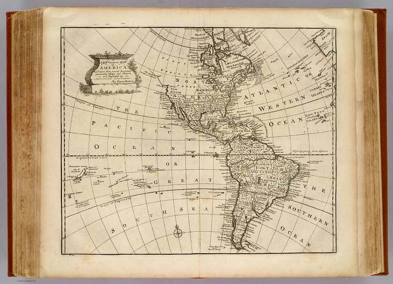
Bowen, Emanuel
Full Title
A new general map of America. Drawn from several accurate particular maps and charts, and regulated by astronomical observations. By Eman. Bowen. (London: Printed for William Innys, Richard Ware, Aaron Ward, J. and P. Knapton, John Clarke, T. Longman and T. Shewell, Thomas Osborne, Henry Whitridge ... M.DCC.XLVII)
List No
3733.050
Note
Engraved map. Relief shown pictorially. Includes historical notes and ornamental cartouche.
Author
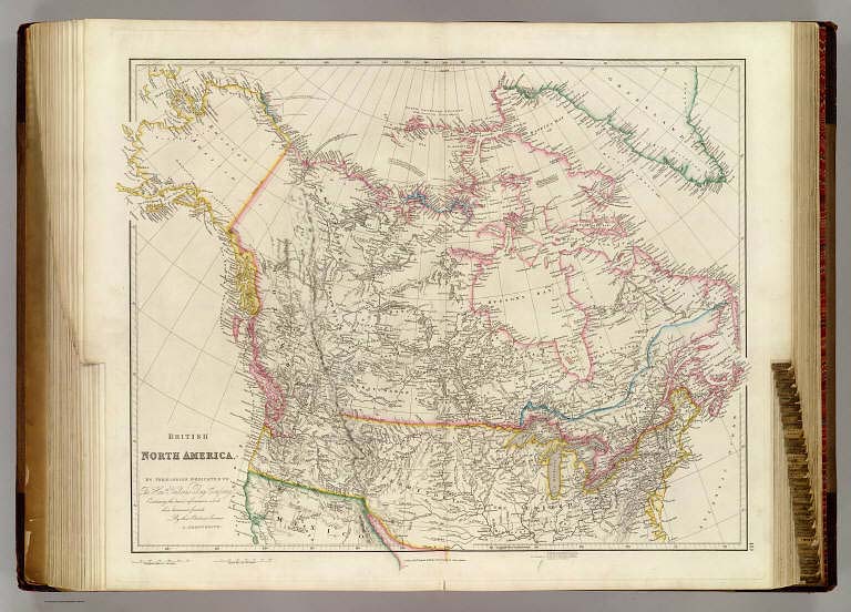
Arrowsmith, John
Full Title
British North America. By Permission Dedicated to The Honble. Hudsons Bay Company; Containing the latest information which their documents furnish. By their Obedient Servant J. Arrowsmith. (Map) 40. London, Pubd. 25 April 1844, by J. Arrowsmith, 10 Soho Square.
List No
4613.040
Note
In outline color.
Author
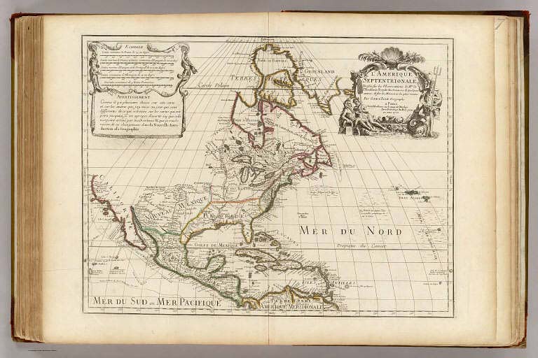
L'Isle, Guillaume de, 1675-1726
Full Title
L'Amerique Septentrionale. Dressee sur les observations de Mrs. de l'Academie Royale des Sciences, & quelques autres, & sur les Memoires les plus recens. Par G. de l'Isle, Geographe. A Paris, chez l'Auteur sur le Quai de l'Horloge, avec Privilege du Roy pour 20. ans, 1700.
List No
4764.095
Note
Engraved map in outline color. Relief shown pictorially. Shows routes of Cortez, Gaetan, Drake, Medana and Olivier in the Pacific. Extends east to the Azores. Below title cartouche, the imprint of L. Renard Libraire, Amsterdam has been erased from the engraving plate. Title cartouche is by "N. Guerard, inv. et fec." "Avertissement" is in a cartouche below bar scales.
|