|
REFINE
Media Group: Lewis and Clark
1-30 of 30
Author
[Allen, Paul, Biddle, Nicholas, Clark, William, Lewis, Meriwether]
Full Title
(Title Page to) History Of The Expedition Under The Command Of Captains Lewis And Clark, To The Sources Of The Missouri, Thence Across The Rocky Mountains And Down The River Columbia To The Pacific Ocean. Performed During The Years 1804-5-6. By order of the Government Of The United States. Prepared For The Press By Paul Allen, Esquire. In Two Volumes. Vol. I. Philadelphia: Published By Bradford And Inskeep, New York. J. Maxwell, Printer. 1814 ... Vol. II.
List No
3493A
Note
1st edition. Notwithstanding the title, Nicholas Biddle completed the text after Lewis's suicide. The map and the written account of the expedition changed American mapping of the northwest by giving the first accurate depiction of the relationship of the sources of the Missouri, the sources of the Columbia, and the Rocky Mountains. The map was copied by Samuel Lewis from William Clark's original drawing, and was engraved by Samuel Harrison. The title of the map is "A Map of Lewis and Clark's Track, Across the Western Portion of North America From the Mississippi to the Pacific Ocean ..." Maps are without color. In 2 volumes newly bound in full leather with the title "Lewis & Clark's Expedition ..." stamped in gilt on the spine.
Author
[Allen, Paul, Biddle, Nicholas, Clark, William, Lewis, Meriwether]
Full Title
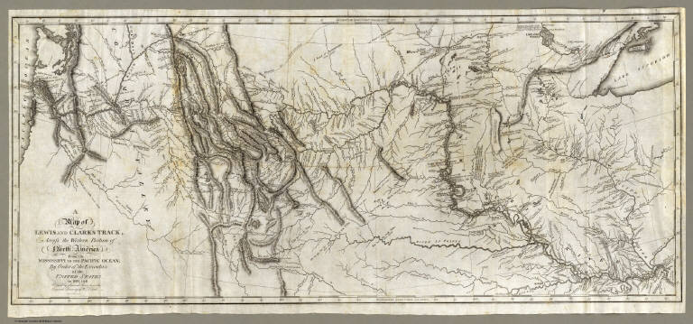
A Map of Lewis and Clark's Track, Across the Western Portion of North America From the Mississippi to the Pacific Ocean; By Order of the Executive of the United States, in 1804, 5 & 6. Copied by Samuel Lewis from the Original Drawing of Wm. Clark. Smal. Harrison fct.
List No
3493.001
Note
Uncolored map showing topography and rivers in the region as well as towns, Indian villages, and population figures. Bound into the front of volume one.
Author
[Allen, Paul, Biddle, Nicholas, Clark, William, Lewis, Meriwether]
Full Title
Fortification.
List No
3493.002
Note
Uncolored map showing remains of a fortification on the Missouri River.
Author
[Allen, Paul, Biddle, Nicholas, Clark, William, Lewis, Meriwether]
Full Title
The Falls and Portage.
List No
3493.003
Note
Uncolored map showing the falls along the upper Missouri along with the portage route (17 miles) used by the Corps of Discovery.
Author
[Allen, Paul, Biddle, Nicholas, Clark, William, Lewis, Meriwether]
Full Title
Great Falls of Columbia River.
List No
3493.004
Note
Uncolored map showing the falls and listing their height. Portage and the camp also shown.
Author
[Allen, Paul, Biddle, Nicholas, Clark, William, Lewis, Meriwether]
Full Title
The Great Shoot or Rapid.
List No
3493.005
Note
Map showing the Great Shoot along the Columbia River. Villages, houses, and topography included. Without color.
Author
[Allen, Paul, Biddle, Nicholas, Clark, William, Lewis, Meriwether]
Full Title
Mouth of Columbia River.
List No
3493.006
Note
The mouth of the Columbia River and environs. Encampment, local village, and distances to nearby points shown on this uncolored map.
Author
[Cartography Associates, Rumsey, David, 1944-, Telemorphic, Inc.]
Full Title
(Lewis and Clark Expedition 200th anniversary mosaic by David Rumsey and Telemorphic, Inc.). Copyright 2002 Cartography Associates and Telemorphic, Inc.
List No
5681.000
Note
Col. printout of SID image combining historic and current maps and remote sensing imagery.
Author
Arrowsmith, Aaron
Full Title
A Map Exhibiting all the New Discoveries in the Interior Parts of North America, Inscribed by Permission To the Honorable Governor and Company of Adventurers of England Trading into Hudsons Bay. In testimony of their liberal Communications. To Their most Obedient and very Humble Servant, A. Arrowsmith. Hydrographer to H.R.H. the Prince of Wales. No. 10 Soho Square. January 1st, 1795. Additions to 1811. Puke Sc.
List No
4189.000
Note
This issue is the seventh (Heckrotte) and makes changes to the Canadian waterways, when compared to the 1802 editions. The American West has been largely unchanged since the first issue of 1795. In the next issue (1814) there are massive changes in the American West. Map in light outline color.
Author
Burr, David H., 1803-1875
Full Title
Oregon Territory. Illman & Pilbrow Sc. Entered ... 1833 by Illman & Pilbrow ... New-York.
List No
4628.048
Note
In full color by region.
Author
Burr, David H., 1803-1875
Full Title
Map of the United States Of North America With parts of the Adjacent Countries, By David H. Burr. (Late Topographer to the Post Office.) Geographer to the House of Representatives of the U.S. John Arrowsmith. Entered ... July 10th, 1839, by David H. Burr ... District of Columbia.
List No
0104.001
Note
This is the "Map of the United States of North America..." from Burr's American Atlas which consists of 13 separate sheets dissected & mounted on linen. In full color by state, country, or region. In 8 sections mounted on linen. Label on back states "No. 1. United States."
Author
Colton, G.W.
Full Title
Nebraska And Kanzas. Published By J.H. Colton & Co. No. 172 William St. New York. Entered ... 1855 by J.H. Colton & Co. ... New York. No. 50.
List No
0149.055
Note
In full color by state. Nebraska extends from the western banks of the Missouri to the Rocky Mountains from east to west and from the northern border of the US to the 40th parallel from north to south. Route of the proposed Pacific Railroad shown.
Author
[DeLacy, W.W., G.W. & C.B. Colton & Co.]
Full Title
Map Of The Territory Of Montana with portions of the Adjoining Territories Compiled and drawn by W. W. DeLacy Civil Engineer & Surveyor. Helena, M. T. 1872. Second Edition, corrected & improved. Engraved Printed and Published By G.W. & C.B. Colton & Co. No. 172 William St. New York. Entered ... 1870 by W. W. DeLacy ... Washington. (with one inset map)
List No
5415.001
Note
Map in outline color with the State of Montana colored by county and including a color scale indicating military reserves and mines (gold, silver, copper, iron, and coal). Phillips lists a map by this title and drawn by DeLacy in 1865. The publisher is J. Hutawa of St. Louis. Encased in a 16x10 brown cloth covered case with "Map of Montana. G. W. & C. B. Colton & Co." in gold on the cover. The inset map of the Northwestern portion of the United States is in full color.
Author
Hayden, F.V.
Full Title
U.S. War Department Map Of The Yellowstone And Missouri Rivers And Their Tributaries explored by Capt. W.F. Raynolds Topl. Engrs. and 1st Lieut. H.E. Maynadier 10th Infy. Assistant. 1859-60. To accompany a report to the Bureau of Topographical Engineers. Lt. Col. Harman Bache in charge. Engraved in the Engineer Bureau War Dept. Prepared to accompany the Geological Report of F.V. Hayden M.D. ... Printed by Julius Bien, N.Y.
List No
2769.001
Note
Map from the report of 1869. Striking, full color, large geological map based on Raynold's "Yellowstone" map.
Author
Ide, Arthur W.
Full Title
Ide's Map Of Montana. Compiled & Drawn By Reeder & Helmick. Helena, Montana. Published by Arthur W. Ide. No. 20 Bailey Block, Helena, Montana. 1890. Copyright by Arthur W. Ide 1890. J.L Smith Lithographer, Phila. Pa.
List No
3334.001
Note
With 16 page Index to A.W. Ide's Map of Montana. Scarce locally published map of Montana, which appears to derive from the army maps of the period. Reeder and Helmick drew the map and are unknown. Full color by county. Folded into blue cloth covers 17x11 with "Ide's New Map Of Montana Published By A.W. Ide, Helena, Mont. 1891." in gilt.
Author
Keeler, William J.
Full Title
National Map Of The Territory Of The United States From The Mississippi River To The Pacific Ocean. Made by the authority of the Hon. O.H. Browning, Secretary of the Interior. ... Compiled from authorized explorations of Pacific Rail Road Routes, Public Surveys, and other reliable data from the Departments of the Government at Washington, D.C. by W.J. Keeler, Civil Engineer. 1868. Entered ... 1867 by Wm. J. Keeler ... Columbia. N. DuBois Draughtsman.
List No
4640.001
Note
This is the reduced issue with slightly more coverage in the east and more progressed railroad development. The detail is, of course, less, due to the smaller scale, and the minerals are not colored in. Nonetheless it is still an excellent map of the west in its time, and is far more scarce than the larger issue of 1867. Full color by state, folded into brown cloth covers 18x11.5 with "Keeler's Map Of The U.S. Territories, Pacific R.R. Routes, Mineral Lands, And Indian Reservations. 1868." stamped in gilt.
Author
[James, Edwin, Long, Stephen H.]
Full Title
(Composite Map of) Country drained by the Mississippi Eastern Section (and) Western Section. Drawn by S.H. Long Maj. T. Engineer. Engrav'd by Young & Delleker.
List No
0343.004
Note
Uncolored composite map. The London edition of Long joins the two maps into one.
Author
[Bodmer, Karl, Maximilian of Wied, Thorn, William]
Full Title
Carte itineraire de Prince Maximilian de Wied dans l'interieur de l'Amerique Septentrionale de Boston a Missouri superieur &c. en 1832, 33 et 34. Reise Charte des Prinzen Maximilian zu Wied ... Map to illustrate the route of Prince Maximilian of Wied in the interior of North America from Boston to the Upper Missouri &c. in 1832, 33, & 34 ... (Printed from the original plate in 1993). (with) Great Falls of the Missouri. (with) Itaska Lake or Lac Labiche: the source of the, Der Ursprung des, Mississippi.
List No
3830.000
Note
A restrike from the original plate. Originally thought to be drawn by Bodmer, current research suggests that the cartographer was Lt. Col. William Thorn who used Tanner's Map of the United States of America, 1837 edition, as a source. The first ed. was published in Germany in 1839. With outline color. Relief shown by hachures. Ornamental title cartouche. Prime meridians: Washington and Greenwich.
Author
Mullan, John
Full Title
General Map of the North Pacific States and Territories Belonging to the United States and of British Columbia, Extending from Lake Superior to the Pacific Ocean and Between Latitude 39 degrees and 53 degrees North. Exhibiting Mail Routes, Gold Mines, and Including the Most Recent Surveys of the Topographical Bureau. Prepared by Captain John Mullan. ... Drawn by Edward Freyhold, T.E. Lithographed by J. Bien, 24 Vesey, St. N.Y.
List No
0652.001
Note
Mullan/Freyhold map, titled "General Map of the North Pacific States and Territories Belonging to the United States and of British Columbia ... Exhibiting Mail Routes, Gold Mines ... Drawn by Edward Freyhold, T.E." Strange Owyhee depiction - shows Kearney River and the Jordan Creek flowing into the Owyhee and a road from "Star City" on the Humboldt (which is actually in Buena Vista Valley south of the Humboldt!) going north through the Owyhee to Boise. Map is very incorrect regarding northern Nevada and Southeastern Oregon. Further study needed. Explore the relationship to Williamson's map of 1866. Kearney River comes from the Dixon map of 1860, but Dixon puts the Kearney where Freyhold puts the Jordan. Much detail on the Owyhee Mines in the addenda. Bound with brown linen covered boards with title on the spine.
Author
Nicollet, J. N. (Joseph Nicolas), 1786-1843
Full Title
Hydrographical Basin of the Upper Mississippi River From Astronomical and Barometrical Observations Surveys and Information by J.N. Nicollet ... assisted ... by Lieut. J.C. Fremont ... Reduced and compiled under the direction of Col. J.J. Abert in the Bureau of the Corps of Topl. Engrs. by Lieut. W.H. Emory ... 1843 ... W.J. Stone Sc.
List No
2488.001
Note
First edition, first issue. A larger version of the accompanying map was issued in 1842 with scale of 1:600,000 - this version is unknown to us (and anyone else we have met)- Bray states that only 200 copies were printed; the House of Representatives issued this 1843 edition in 1845 with no changes, although Wagner Camp says the map was smaller and Bray states that it was a more faithful representation of the original 1842 map. See Donald Jackson, The Expeditions of John Charles Fremont, for a history of the Nicollet map and all the Fremont maps. Fremont worked extensively with Nicollet on this map and "this was the work which trained Fremont in cartography." (Jackson). This map was the earliest accurate map of the Northern Plains and the Upper Mississippi. G.K. Warren, in his Memoir, stated that this "map was one of the greatest contributions ever made to American geography." Nicollet died in 1843. His map was years ahead of its time, with its regional concept and sound basis in instrument readings and astronomically determined points. Goetzmann: "Had he lived one more decade, Nicollet would undoubtedly have become the official government cartographer of the whole trans-Mississippi West." Rebound in brown fabric covers with "Hydrographical Basin of the Upper Mississippi, I.N. Nicollet, 1843" in gold on the spine.
Author
Tanner, Henry S.
Full Title
(Composite of) A Map of North America, Constructed According To The Latest Information: by H.S. Tanner. S.E. Sheet. Entered ... 27th day of May 1822, by H.S. Tanner ... Pennsylvania. Engraved & Published by H.S. Tanner. Philadelphia. 1822. Printed by Wm. Duffee. American Atlas.
List No
5388.013
Note
Composite of the four North American map sheet. Scale measured at 10 degrees latitude. In full color.
Author
U.S. General Land Office
Full Title
Sketch of the Public Surveys in the State of Minnesota. Department of the Interior, General Land Office, October 2nd 1866. Jo. S. Wilson, Commissioner. The Major & Knapp Eng. Mfg. & Lith. Co. 71 Broadway, N.Y. Joseph Gorlinski Draughtsman, G.L.O.
List No
1070.006
Note
In outline color. The "6 mile limits" are shown in pink. The seat of the Surveyor General's Office is shown in green.
Author
U.S. General Land Office
Full Title
(12) Map Showing the progress of the Public surveys in Kansas and Nebraska. 1866. Surveyor General's Office, Leavenworth, Kansas, August 25th, 1866. Department of the Interior, General Land Office, October 2nd 1866. Jo. S. Wilson, Commissioner. No. 15. Bowen & Co. lith. Philada.
List No
1070.015
Note
In outline color with the land offices in pink and the surveyor general's office in green. The legend includes coal, lead, platina, marble, and salt lands.
Author
U.S. General Land Office
Full Title
Map of the United States and Territories, Showing the extent of Public Surveys and other details. Constructed From the Plats and official sources of the General Land Office, Under the direction of the Hon. Jos. S. Wilson, Commissioner, by Joseph Gorlinski, Draughtsman, 1867. Julius Bien, N.Y. Department of the Interior General Land Office Oct. 15th 1867. Jos. S. Wilson, Commissioner.
List No
1882.001
Note
Map accompanied the annual report of 1867. Map in full color by state. Map includes the township and range lines throughout the Midwest, south and west. Proposed surveys are indicated by dotted lines. An explanation at the lower left of the map includes symbols for gold, silver, copper, quicksilver, iron, tin, asphaltum, coal, and oil springs. Land offices are in bright red with the Surveyor Generals' Office in green. The report is bound with green linen and "Land Office Report. 1867. Abridgment" on the cover in gold.
Author
U.S. General Land Office
Full Title
Department Of The Interior General Land Office J.A. Williamson, Commissioner. State of Iowa. 1878. Compiled from the official Records of the General Land Office and other sources by C. Roeser, Principal Draughtsman G.L.O. Photo lith & print by Julius Bien 16 & 18 Park Place N.Y.
List No
5451.000
Note
Printed outline color for counties with rivers shown in green.
Author
U.S. General Land Office
Full Title
Department Of The Interior General Land Office J.A. Williamson, Commissioner. State of Missouri. 1878. Compiled from the official Records of the General Land Office and other sources by C. Roeser, Principal Draughtsman G.L.O. Photo lith & print by Julius Bien 16 & 18 Park Place N.Y.
List No
5452.000
Note
Printed outline color for counties and green for the waterways.
Author
U.S. General Land Office
Full Title
Department Of The Interior General Land Office J.A. Williamson, Commissioner. Washington Territory. 1879. Compiled from the official Records of the General Land Office and other sources by C. Roeser, Principal Draughtsman G.L.O. Photo lith & print by Julius Bien 16 & 18 Park Place N.Y.
List No
3461.000
Note
Printed in color, probably the first such.
Author
U.S. General Land Office
Full Title
Department Of The Interior General Land Office J.A. Williamson, Commissioner. Territory Of Wyoming. 1879. Compiled from the official Records of the General Land Office and other sources by C. Roeser, Principal Draughtsman G.L.O. Photo lith & print by Julius Bien 16 & 18 Park Place N.Y.
List No
4618.000
Note
The second separately published GLO map of Wyoming, after the 1876 issue. Yellowstone National Park is shown with good detail. Printed color.
Author
U.S. General Land Office
Full Title
Department Of The Interior General Land Office J.A. Williamson, Commissioner. Territory Of Idaho. 1879. Compiled from the official Records of the General Land Office and other sources by C. Roeser, Principal Draughtsman G.L.O. Photo lith & print by Julius Bien 16 & 18 Park Place N.Y.
List No
4619.000
Note
Printed color, minimal detail in the interior of the territory.
Author
U.S. General Land Office
Full Title
Department Of The Interior General Land Office J.A. Williamson, Commissioner. Territory Of Dakota. 1879. Compiled from the official Records of the General Land Office and other sources by C. Roeser, Principal Draughtsman G.L.O. Photo lith & print by Julius Bien 16 & 18 Park Place N.Y.
List No
4645.000
Note
Good detail on the Black Hills. Printed color.
1-30 of 30
|