|
REFINE
Media Group: HGIS Regesta Imperii
1-8 of 8
Author
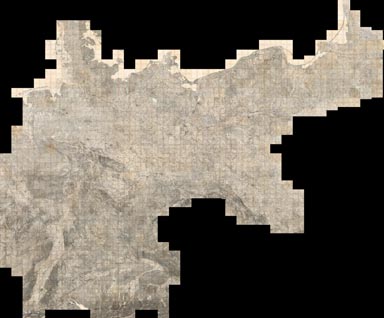
Reichsamt fur Landesaufnahme
Full Title
(Composite of) Sheets 1 - 674 (Germany)
List No
5820.727
Note
Composite of Sheets 1 to 674. Date estimated based on the apparent library acquisition date usually stamped on the back of the map sheet. This map series is remarkable for the level of fine detail. As a consequence, it was scanned at 800 PPI providing four times the resolution of the typical detailed map scan of 400 PPI. At least ten separate symbols for special buildings were utilized, a method enhanced by placing an abbreviation next to the symbol. Structures with special symbols include: churches, chapels, monuments, windmills, water mills, stamp mills, forester's lodges, watchtowers, ruins, forts, quarries, clay pits, lime kilns, and coke-ovens. Factories, brick works, powder magazines electric power plants, and many other important buildings are differentiated by means of abbreviation. Houses appear as black blocks, either rectangular or shaped like the ground plan of the building. Many other features are differentiated, for example there are four different qualities of roads plus bridle paths and footpaths. Vegetation is minutely classified including separate symbols for broadleaf trees, evergreens, underbrush, heather, dry meadows, wet meadows, swamps, orchards, gardens, vineyards, and parks. Relief is shown by hachures. Spot elevations are given in meters above sea level.
Author
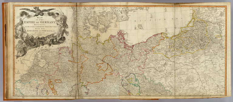
[Delarochette, Louis Stanislas d'Arcy, Robert Laurie & James Whittle]
Full Title
Map of the Empire of Germany, including all the states comprehended under that name: with the Kingdom of Prussia, &c. (North half). By L. Delarochette. London, Published by Laurie & Whittle, No. 53, Fleet Street, 12th May, 1794. (T. Kitchin sculpt.)
List No
2310.038
Note
Hand colored engraved map. Relief shown pictorially. Printed on 2 sheets; joined. Contents: The circles of Westphalia and Lower Saxony, with the western parts of the Circle of Upper Saxony, and the northern parts of the Circle of Upper Rhine, part of Sweden, and Denmark; the United Provinces, and part of the Netherlands -- Eastern parts of Brandenburg and Saxony, with Pomerania, Prussia, Lusatia, and the northern parts of Silesia; part of Sweden, Samogitia, Lithuania, and Poland.
Author
[Woerl, Joseph Edmund, Herder, Benjamin]
Full Title
(Covers to) Das Koenigreich Wuerttemberg Das Grossherzogthum Baden und die Fuurstenthuumer Hohenzollern : entworfen und bearbeitet im Maasstabe 1:200 000 in 12 Blaettern von I.E. Woerl ; in Stein gestochen unter seiner Leitung. Eine Abteilung der von Obrist Weiss entworfenen Karte von Suddeutschland. In tiefster ehrfurcht aller untertanigst gewidmet von H. Heder. [Gewidmet] Grosherzog Leopold von Baden. Woerl dir: 1831. Im Herder'schen Kunst-Institut in Freburgn im Breisgan. (at head of title) 1830.
List No
6829.001
Note
Maps of southwesterm Germany by Joseph Edmund Woerl, mapmaker in Freiburg 1830-1838. An important document about the road network. Red lithographic stone printing. In 23 parts (20 maps 43x46, a title page with decorative illustrations, sample maps and coat of arms, index sheet, and table) placed in cardboard case 54x64, with title "Woerl Atlas der Wuerttemberg." All the maps are at the same scale (1:200,000) and fit together into either one very large composite of all 48 maps or sub-maps of Switzerland (19 sheets plus title, see our 6824.000), Wurtttemberg (12 sheets including title) and Baden. We do not have all 48 maps but rather 24 in this group and 19 in the Switzerland group (although 3 maps appear in both groups, so our net total maps is 39 of 48).
Author
[Woerl, Joseph Edmund, Herder, Benjamin]
Full Title
Strasburg. Entworfen und bearbeitet von Woerl in Stein gestochen unter seiner Leitung 1833. Im Herder'schen Kunst-Institut in Freburgn im Breisgan. (to accompany) Das Koenigreich Wuerttemberg Das Grossherzogthum Baden und die Fuurstenthuumer Hohenzollern.
List No
6829.010
Note
Red lithographic stone printing map. Shows roads, fortifications, canals, major public buildings, etc. Relief shown by form lines and spot heights.
Author
Stieler, Adolf
Full Title
Mittel Europaische Staaten; entw. u. gez. v. A. Stieler 1818. L. Michaelis sc. (upper right margin) Hand-Atl. No. 17. (to accompany) Hand-Atlas uber alle Theile der Erde, nach dem neuesten Zustande und uber das Weltgebaude.
List No
6830.029
Note
Engraved outline hand color map. Relief shown by hachures.
Author
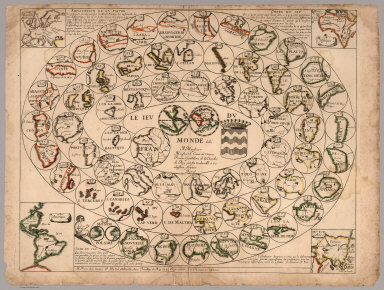
Du Val, Pierre, 1619-1683
Full Title
Le Jeu du Monde dédié à Monsieur, Monsieur le Comte de Vivone, premier gentilhome de chambre du Roy par son très humble et très obéissant serviteur Duval. A Paris chez l'auteur P. Du Val d'Abbeville, avec Privilége du Roy, 1645, et se vendant rue S.t Jacques à l'Espérance
List No
6728.000
Note
This is one of the earliest geographical games that we have seen. Only one other copy is known of this game, held by the Bibliothèque nationale de France. The object of the game is to progress from the outer parts of the world in towards the center (France) by rolling dice and moving each player's piece from circle to circle on the board. California is shown as an island in circle 5. Duval also made a similar game of France. The rules to the game are shown here https://www.dhi.ac.uk/hartlib/view?docset=main&docname=8A_06
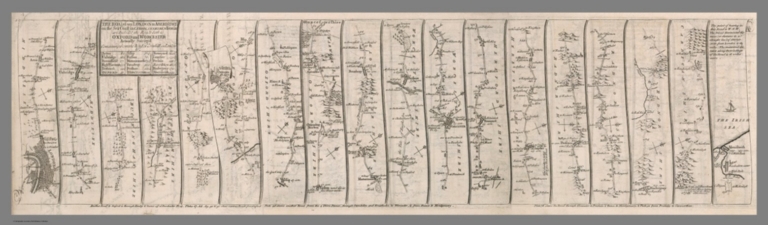
Author
[Senex, John (1680-1740), Wilkinson, Robert, Ogilby, John (1600-1676)]
Full Title
(Composite map) The road from London to Aberistwith : on the sea coast com. Cardigan, wherein are included the roads to Oxford and Worcester, Actually surveyed. I. Senex Sculpt. (to accompany)The roads through England delineated, or, Ogilby's survey : revised, improved, and reduced to a size portable for the pocket by John Senex, F.R.S. ... Publish'd ... 1st May 1780, by R. Wilkinson ... Cornhill, London.
List No
2634.011
Note
Composite to sheets 1-3, road from London to Aberistwith.
Author
Colortext Publications Inc.
Full Title
Military Panoramap of the Theatre of War. Observation Point 200 Miles Directly Above Bern. Colortext Publications Inc. Chicago, Ill. - 1940.
List No
10127.000
Note
Colored copy. Panoramic view centers on France and Germany but includes, at its borders, portions of England, France, Switzerland, Norway, Sweden and other European nations. Along the Rhine, Germany’s defensive Siegfried Line is shown. The English Channel separating England and France is shown defended by the Dover Patrol, comprised not only of ships as in WWI, but also aircraft. The map’s border is particularly striking, with images of aircraft across the top, warships across the bottom, and heavy artillery and tanks in the margins right and left. Shows rivers, mountains, landmarks, major cities and towns. Relief shown pictorially and by shadings. Includes distnces.
1-8 of 8
|