|
REFINE
Media Group: indian maps
1-18 of 18
Author
Jackson, Henry
Full Title
Indian Territory With Parts Of Neighboring States And Territories. Prepared By Order Of Maj. Gen. J.M. Schofield. Compiled under direction of 1st Lieut. Henry Jackson, 7th U.S. Cavalry, September 1869. Bvt. Maj. Gen. A.A. Humphreys, Chief of Engineers. Drawn by Ado Hunnius. J. Bien, photo-lith.
List No
3851.000
Author
[Johnston, Alexander Keith, 1804-1871, Rogers, Henry Darwin]
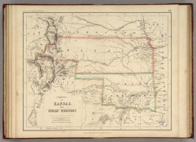
Full Title
Territory of Kansas And Indian Territory. By Prof. H.D. Rogers & A. Keith Johnston, F.R.S.E. Entered in Sta. Hall. London ... & according to an act of Congress ... 1857, by H.D. Rogers ... Massachusetts. London, John Murray, Albemarle Street, Edinburgh, W. & A.K. Johnston. Engraved by W. & A.K. Johnston, Edinburgh.
List No
3825.013
Note
Kansas and Indian Territory (Oklahoma) are shown in printed outline color with proposed railway routes in purple.
Author
[Martin, R.M., Tallis, J. & F.]
Full Title
Islands In The Indian Ocean. (with) inset map of Mauritius. The Illustrations Drawn & Engraved by H. Winkles. The Map Drawn & Engraved by J. Rapkin.
List No
0466.049
Note
Islands and countries in outline color. Drawings of the different ports included. Decorative border.
Author
Gregg, Josiah, 1806-1850
Full Title
A Map of the Indian Territory Northern Texas and New Mexico Showing the Great Western Prairies by Josiah Gregg. Entered ... 1844 by Sidney E. Morse and Samuel Breese ... New York.
List No
2351.001
Note
Map colored in green stretching from the borders of Arkansas and Missouri to the Southern Rocky Mountains. A chart explaining the map symbols is included.
Author
Gallatin, Albert
Full Title
(Title Page to) A Synopsis of the Indian Tribes Within the United States East of the Rocky Mountains, and in the British and Russian Possessions in North America. By the Hon. Albert Gallatin. (In: Archaeologia Americana. Transactions and Collections of the American Antiquarian Society. Vol II. Cambridge: Printed For The Society, At The University Press. 1836).
List No
3388A
Note
The map, in addition to its abundant information regarding the Indian Tribes, shows Jedediah Smith's route of 1827 across the Great Basin, one of the earliest American maps to do so. See the later version of this map published in 1848 (our #3609).
Author
Gallatin, Albert
Full Title
Map of the Indian Tribes of North America about 1600 A.D. along the Atlantic; & about 1800 A.D. westwardly. Published by the Amer: Antiq: Soc: From a drawing by Hon: A. Gallatin.
List No
3388.001
Note
Map in color by tribe. Map extends from Alaska and Baffin's Bay in the north to Florida in the south. Accompanied by a color-coded key.
Author
Robert Sayer and John Bennett (Firm)
Full Title
A General Map of the Southern British Colonies, in America. containing North and South Carolina, Georgia, East and West Florida, with the Neighbouring Indian Countries. From the Modern Surveys of Engineer de Brahm, Capt. Collet, Mouzon & Others; and from the Large Hydrographical Survey of the Coasts of East and West Florida. By B. Romans, 1776. (with) Plan of Charleston and ... St. Augustine. London: Printed for R. Sayer & J. Bennett ... 15th Octr. 1776.
List No
0875.005
Note
In outline color. Above the map reads, "The Seat of War in the Southern British Colonies comprehending North and South Carolina, Georgia, East and West Florida, &ca."
Author
Arbuckle Bros.
Full Title
Indian Territory, New Mexico, South Dakota, Texas. Copyright 1889 Arbuckle Bros. N.Y.
List No
0027.005
Note
Sheet with maps of four states in full color. "Indian Territory" is now known as Oklahoma. It is noted that, "Of the 41,000,000 acres in the Territory, nearly 26,000,000 have been surveyed and set apart as reservations for the Indians. These have been gathered from all parts of the country, from Oregon to Florida, in pursuance of the general plan of congregating all the Indians in one territory, to be theirs forever." Each card measures 7.5 x 12.5 cm.
Author
Berghaus, Heinrich
Full Title
Physikalische Karte vom Indischen Meere. 2te Abtheilung: Hydrographie, No. 5. Potsdam, in der geograph. Kunstschule. Bei J. Perthes in Gotha. 1840. Gestochen bei Madel II.
List No
2515.016
Note
Map of the Indian Ocean showing sea temperatures, trade routes, and air currents in outline color.
Author
Colton, J. H.
Full Title
(Covers to) Nebraska And Kansas. Published By J.H. Colton & Co. No. 172 William St. New York. Entered ... 1854 by J.H. Colton ... New York. (inset) Map Of The Territory acquired from Mexico by the Gadsden Treaty, 1854. (untitled inset of U.S., Mexico, Central America). Printed by D. Mc Lellan, 26 Spruce St. N.Y.
List No
3873A
Author
Colton, J. H.
Full Title
Nebraska And Kansas. Published By J.H. Colton & Co. No. 172 William St. New York. Entered ... 1854 by J.H. Colton ... New York. (inset) Map Of The Territory acquired from Mexico by the Gadsden Treaty, 1854. (untitled inset of U.S., Mexico, Central America). Printed by D. Mc Lellan, 26 Spruce St. N.Y.
List No
3873.001
Note
First edition, first state. First map to show the new Kansas and Nebraska; also shows the important Gadsden Purchase of the same year. This state precedes all other copies we have seen - it is an early pull from the late 1854, early 1855 Colton Map of the United States of America... wall map plate (see our #2834, indicating it appeared in middle or late 1854 - see our 1855 wall map copy #2278 for the corrected topography), with the title different from the second 1854 state, in that the letters of Nebraska and Kansas have stars in them and are open as opposed to the black letters of the second state. Also, this first state has numerous areas that are "cleaned up" in the second state: the trail that crosses the two forks of the Colorado in southern Utah near the map edge has the word "Route" on it - this is removed in the second state; the vine border is reversed from the first to the second state; Louisiana is written straight across in the first - it curves down in the second; Bucksport and San Augustine are shown in Texas along the map southern edge in the second state and not in the first; Sacket's Well and Laguna in California in the inset map are given dots for their location in the second state but not in the first. There are other changes. Streeter shows a second edition in 1855, Heaston a third edition in 1856, but both copyrighted 1855. These have various route changes and place names added when compared to the 1854. A fourth edition appeared in 1857 (see Karrow 12-0361.2 and Graff 836) with the inset of the U.S. changed to Eastern Nebraska and Kansas. Map is full color by state, folded into red cloth covers 15x9 with "Nebraska And Kansas" stamped in gilt, advertisement for Colton on inside front cover.
Author
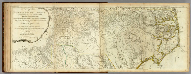
[Jefferys, Thomas, Mouzon, Henry]
Full Title
An Accurate Map Of North And South Carolina With Their Indian Frontiers, Shewing in a distinct manner all the Mountains, Rivers, Swamps, Marshes, Bays, Creeks, Harbours, Sandbanks and Soundings on the Coasts; with The Roads and Indian Paths; as well as The Boundary or Provincial Lines, The Several Townships and other divisions of the Land In Both The Provinces; the whole From Actual Surveys By Henry Mouzon And Others. London. Printed for Robt. Sayer and J. Bennett ... May 30th 1775. (Northern Section)
List No
0346.026
Note
In outline color by state. In two sections with this being the northernmost. Large title cartouche at upper left.
Author
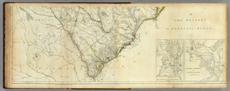
[Jefferys, Thomas, Mouzon, Henry]
Full Title
An Accurate Map Of North And South Carolina With Their Indian Frontiers, Shewing in a distinct manner all the Mountains, Rivers, Swamps, Marshes, Bays, Creeks, Harbours, Sandbanks and Soundings on the Coasts; with The Roads and Indian Paths; as well as The Boundary or Provincial Lines, The Several Townships and other divisions of the Land In Both The Provinces; the whole From Actual Surveys By Henry Mouzon And Others. (with) two inset maps: The Harbour of Port Royal and The Bar and Harbour of Charlestown. London. Printed for Robt. Sayer and J. Bennett ... May 30th 1775. (Southern Section)
List No
0346.027
Note
In outline color by state. In two sections with this being the southern. Title cartouche on northern section.
Author
[Jefferys, Thomas, Mouzon, Henry]
Full Title
(Composite of) An Accurate Map Of North And South Carolina With Their Indian Frontiers, Shewing in a distinct manner all the Mountains, Rivers, Swamps, Marshes, Bays, Creeks, Harbours, Sandbanks and Soundings on the Coasts; with The Roads and Indian Paths; as well as The Boundary or Provincial Lines, The Several Townships and other divisions of the Land In Both The Provinces; the whole From Actual Surveys By Henry Mouzon And Others. London. Printed for Robt. Sayer and J. Bennett ... May 30th 1775.
List No
0346.028
Note
In outline color by state.
Author
U.S. General Land Office
Full Title
(Covers to) Indian Territory. 1879. Department Of The Interior, General Land Office, J.A. Williamson, Commissioner. Compiled from the official Records of the General Land Office and other sources by C. Roeser, Principal Draughtsman, G.L.O. Photo lith & print by Julius Bien 16 & 18 Park Place, N.Y.
List No
4595A
Author
U.S. General Land Office
Full Title
Indian Territory. 1879. Department Of The Interior, General Land Office, J.A. Williamson, Commissioner. Compiled from the official Records of the General Land Office and other sources by C. Roeser, Principal Draughtsman, G.L.O. Photo lith & print by Julius Bien 16 & 18 Park Place, N.Y.
List No
4595.001
Note
An unusual issue by Rand McNally, folded into their covers with paste down ad for their maps on the inside cover, but entirely the GLO map with no Rand McNally overprinting. Outline color. Folded into untitled black cloth covers 16.5x10.5.
Author
U.S. War Department
Full Title
(Covers to) Engineer Bureau, War Department. Map Of The States Of Kansas And Texas And Indian Territory, With Parts Of The Territories Of Colorado And New Mexico. From the most recent official surveys and explorations and other authentic information. 1867. J. Bien, Lith. 24 Vesey St. N.Y.
List No
2320A
Author
U.S. War Department
Full Title
Engineer Bureau, War Department. Map Of The States Of Kansas And Texas And Indian Territory, With Parts Of The Territories Of Colorado And New Mexico. From the most recent official surveys and explorations and other authentic information. 1867. J. Bien, Lith. 24 Vesey St. N.Y.
List No
2320.001
Note
1st edition. Not in Streeter, Phillips, Wheat. Map shows routes of important reconnaissances, Indian trails, roads, railroads in operation, projected railroads, army routes, Indian lands and reservations. One of the earliest detailed Army surveys of the area. The map was printed in two sheets, a north sheet and a south sheet. The north sheet appears in the Atlas to Accompany the Official Records of the Union and Confederate Armies as Plate CXIX, with the same title as this map, but with the title placed in the upper right corner of the north sheet. We also have the North sheet without title, dated c1875, with much additional information on new routes, railroads, etc. This map is signed by William E. Merrill, Maj. Engrs., and dated August 10, 1867. Merrill also signed our copy of the Warren Map of the U.S., 1867, with a signature date of August 26, 1867 Merrill later made maps of Kansas (See Karrow). Graff misspells Merrill's name, as does Streeter (his signature is hard to read). Dissected into 48 sections and mounted on linen. Map folds into two dark green cloth end boards 22.5x13.5 with paper label reading "Kansas, Texas, And Indian Territory, With Parts Of Colorado And New Mexico. Engineer Bureau, W.D. Prepared for Issue in Engineer Office, M.D. Mo. All Person Into Whose Hands The Map Falls Are Particularly Requested To Send All Corrections And Additions To The Chief Engineer, Mil. Div. Of The Mo., St. Louis." With hand painted color.
1-18 of 18
|