|
Author
Fremont, J.C.
Full Title
(Title Page to) Geographical Memoir upon Upper California In Illustration of His Map of Oregon and California, by John Charles Fremont: Addressed to the Senate of the United States. Washington: Wendell and Van Benthuysen, Printers. 1848. [Senate.] 30th Congress, 1st Session. Miscellaneous. No. 148.
List No
1857A
Author
Fremont, J.C.
Full Title
Map Of Oregon And Upper California From the Surveys of John Charles Fremont And other Authorities. Drawn By Charles Preuss Under the Order of the Senate Of The United States, Washington City 1848. Lithy. by E. Weber & Co. Balto. (inset) Profile of the travelling route from the South Pass of the Rocky Mountains to the Bay of San Francisco.
List No
1857.001
Note
The map for the first time filled in the details of the Great Basin. Charles Preuss drew the map. A smaller version of the map appears in President Polk's Message of 1849 (see our copy). Report rebound with cloth covered boards and title on spine.
Author
[Geographical and Geological Survey of the Rocky Mountain Region (U.S.), Jenney, Walter Proctor, 1849-1921, Newton, Henry, 1845-1877]
Full Title
(covers to) Topographical and Geological Atlas of the Black Hills of Dakota to accompany the report of Henry Newton, E.M., assistant geologist. Department of the Interior, United States Geographical and Geological Survey of the Rocky Mountain Region, J.W. Powell, in charge. Julius Bien, Lith. New York, 1879.
List No
2083A
Note
Contains 2 maps, 1 view. David Rumsey copy is half redish leather, with brown cloth. Stamped in gold on cover, "Topographical and geological atlas of the Black Hills of Dakota. Powell. R.H. Rollins." E.H. Rollins copy (see DAB).
Author
[Geographical and Geological Survey of the Rocky Mountain Region (U.S.), Jenney, Walter Proctor, 1849-1921, Newton, Henry, 1845-1877]
Full Title
(Title Page to) Topographical and Geological Atlas of the Black Hills of Dakota to accompany the report of Henry Newton, E.M., assistant geologist. Department of the Interior, United States Geographical and Geological Survey of the Rocky Mountain Region, J.W. Powell, in charge. Julius Bien, Lith. New York, 1879.
List No
2083B
Note
Contains 2 maps, 1 view. David Rumsey copy is half redish leather, with brown cloth. Stamped in gold on cover, "Topographical and geological atlas of the Black Hills of Dakota. Powell. R.H. Rollins." E.H. Rollins copy (see DAB).
Author
[Geographical and Geological Survey of the Rocky Mountain Region (U.S.), Jenney, Walter Proctor, 1849-1921, Newton, Henry, 1845-1877]
Full Title
Bird's eye view of the Black Hills to illustrate the geological structure. Dept. of the Interior, U.S.G. and G. Survey, J.W. Powell, in charge. Geology of the Black Hills by Henry Newton, E.M. (Julius Bien, Lith. New York, 1879)
List No
2083.001
Author
[Geographical and Geological Survey of the Rocky Mountain Region (U.S.), Jenney, Walter Proctor, 1849-1921, M'Gillycuddy, V. T., Mahlo, Emil, 1851-1904, Newton, Henry, 1845-1877, Tuttle, H. P.]
Full Title
Map of the Black Hills of Dakota, from explorations made in 1873. W.P. Jenney, Engineer of Mines, in charge. H. Newton, Engineer of Mines, geologist. V.T. M'Gillycuddy, M.D., topographer. H.P. Tuttle, A.M., astronomer. Drawn by Emil Mahlo. Dept. of the Interior, U.S.G. and G. Survey, J.W. Powell, in charge. Geology of the Black Hills by Henry Newton, E.M. (Julius Bien, Lith. New York, 1879)
List No
2083.002
Note
Color lithograph map. Relief shown by hachures. Includes 3-line note on Sioux Reservation.
Author
[Geographical and Geological Survey of the Rocky Mountain Region (U.S.), Newton, Henry, 1845-1877]
Full Title
Geological map of the Black Hills of Dakota by Henry Newton, E.M. Dept. of the Interior, U.S.G. and G. Survey, J.W. Powell, in charge. Geology of the Black Hills by Henry Newton, E.M. (Julius Bien, Lith. New York, 1879)
List No
2083.003
Note
Color lithograph map. Relief shown by contours, hachures and spot heights.
Author
Arrowsmith, Aaron
Full Title
A Map Of The United States Of North America Drawn from a number of Critical Researches By A. Arrowsmith, Hydrographer to H.R.H. the Prince of Wales. No. 10 Soho Square. London. Published as the Act Directs by A. Arrowsmith, No. 10 Soho Square. Jan 1st, 1796. Additions to 1802.
List No
2098.001
Note
Watermark, J. Whatman 1811, NE sheet, lower left. Comparing to 79(d), 1804, I cannot find the changes indicated by Stevens, and comparing to 79(f), which only has added "-1815" in ms, I cannot find any changes either. It could be that this copy of 79(e) is later than the one Stevens saw as indicated by the 1811 watermark. There may be a 79(e) without the 1811 watermakr that is earlier. Outline color by state. Map is in four sheets, each dissected into 18 sections. Sheets fold, each with a label pasted to the linen backing reading "Sold by W. Faden, Geographer to His Majesty and to His Royal Highness the Prince of Wales. No. 5 Charing Cross." The four map sheets lie folded between two brown card end sheets, inside their original marbled paper slip case 22x13.5 with the same paste down label.
Author
Arrowsmith, Aaron
Full Title
Outlines Of The Physical And Political Divisions Of South America: Delineated By A. Arrowsmith Partly From Scarce And Original Documents, Published Before The Year 1806 But Principally From Manuscript Maps & Surveys Made Between The Years 1771 And 1806, Corrected From Accurate Astronomical Observations To 1810. London, Published 4th January 1811 by A. Arrowsmith No. 10 Soho Square, Hydrographer to H.R.H. the Prince of Wales. Additions to 1814. Engraved by Edwd. Jones ... (inset map of the southern tip of South America).
List No
2099.000
Note
Removed from Arrowsmith's Atlas to accompany Thompson's Alcedo. Comparing to the 1811 77(a) first issue, there are changes in the coast line between Buenos Aires and Rio, and on the northeast coast, Maranham. This map is enormous, on six large sheets, measuring over eight feet tall when joined together. Outline color by country. Without top and bottom rollers.
Author
Andriveau-Goujon, E.
Full Title
(Covers to) Carte Generale Des Etats - Unis Et Du Mexique Comprenant L'Amerique Centrale Et Les Antilles. E. Andriveau-Goujon, Editeur. Paris, Rue Du Bac, 21. 1865 ... (with four inset maps).
List No
2100A
Author
Andriveau-Goujon, E.
Full Title
Carte Generale Des Etats - Unis Et Du Mexique Comprenant L'Amerique Centrale Et Les Antilles. E. Andriveau-Goujon, Editeur. Paris, Rue Du Bac, 21. 1865 ... (with four inset maps).
List No
2100.001
Note
Third edition. Shows Colona, Shoshone, Nevada. The maker of this map must have seen copies of Mitchell's 1859 New National Map - this has the same proposed territorial names that Mitchell used that year. This also has a line dividing the northern and southern states in the civil war. According to Phillips Maps, this was also No. 48 in the Atlas Universel for 1862. Map is dissected into 21 sections and mounted on tan linen with the book plate of Andriveau-Goujon. Covers are dark green cloth 23.5x14.5 with "Etats-Unis Et Mexique. Andriveau-Goujon. Rue Du Bac, 2I." stamped in gold on the front with the same embossed gold and green globe as the 1862 issue. The spine is stamped with "Etats-Unis" in gold. Map has full color by state.
Author
Johnson, D. Griffing
Full Title
(Covers to) Johnson's Illustrated & Embellished Steel Plate Map of The World On Mercator's Projection, Compiled from the latest & most Authentic Sources Exhibiting the recent Arctic and Antarctic Discoveries & Explorations. Engraved & Published By D.Griffing Johnson, 80 Nassau St. New York. 1847. Entered ... 1846 by D. Griffing Johnson ... New York.
List No
2156A
Note
Cover half leather dark brown cloth covered boards 37x42 with "Johnson's World. New-York." stamped in gilt.
Author
Johnson, D. Griffing
Full Title
Johnson's Illustrated & Embellished Steel Plate Map of The World On Mercator's Projection, Compiled from the latest & most Authentic Sources Exhibiting the recent Arctic and Antarctic Discoveries & Explorations. Engraved & Published By D.Griffing Johnson, 80 Nassau St. New York. 1847. Entered ... 1846 by D. Griffing Johnson ... New York
List No
2156.001
Note
Dissected into 20 sections, mounded and edged with linen. With an elaborate vine border with views of important cities. One of the great American World Wall maps of the period. Colton took over the publishing of this map in 1849. See our 1857 issue by Colton. Full color. Table of distances. Shows numerous routes followed by historic mariners including observations of birds on the high seas.
Author
[Barber, B.B., Willard, A.]
Full Title
Map Of The United States Of America With Its Territories & Districts. Including also a part of Upper & Lower Canada And Mexico. Published By B.B. Barber & A. Willard, Hartford, 1835.
List No
2240.000
Note
1st ed. was 1833; later editions by Reed & Barber. An unusual map in two sheets, showing the continent coast to coast. Tanner's influence from his North America map is evident in the west, and Long's map has influenced the plains, but Tanner's U.S. map is the primary source, in the Oregon District, the Plains, and the area east of the Mississippi. The Great Basin is filled with a table of distances and heights of mountains (which convention appears in several maps published in Hartford about this time by Thrall, Huntington, Olney's Geography, etc.). Wheat mentions the 1849 and 1850 editions of this map published by Reed and Barber, but this much earlier and different edition was unknown to him. Not in Phillips. Views of the Capital and the White House. Phelps did a related and somewhat smaller map in 1833 - see our copy. After the 1835 edition, no editions until the 1848 by Reed and Barber (see our 1849, 1850 and 1854 editions). Map is in full color.
Author
Carleton, Osgood
Full Title
(Covers to) Map Of Massachusetts Proper Compiled from Actual Surveys, made by Order of the General Court, and under the inspection of Agents of their appointment, By Osgood Carleton. Engraved by Joseph Callender and Samuel Hill, Boston, 1801. Vignette Drawn by G. Graham.
List No
2258A
Author
Carleton, Osgood
Full Title
Map Of Massachusetts Proper Compiled from Actual Surveys, made by Order of the General Court, and under the inspection of Agents of their appointment, By Osgood Carleton. Engraved by Joseph Callender and Samuel Hill, Boston, 1801. Vignette Drawn by G. Graham.
List No
2258.001
Note
Engraved by Joseph Callender and Samuel Hill. Second map of Massachusetts by Carleton (1st was 1798), reengraved from the plates of the first issue, and the first official state map (the first edition was rejected by the legislature). With outline and full color. Map is dissected into 32 sections and mounted on linen. Folds into original black cardboard slip case 21x16 with a red leather label on the spine reading "Map Of Mass." in gilt.
Author
Sage, Rufus B.
Full Title
(Title Page to) Scenes in the Rocky Mountains, and in Oregon, California, New Mexico, Texas, and the Grand Prairies; or Notes by the Way, During An Excursion Of Three Years, with a Description of the Countries Passed Through, including their Geography, Geology, Resources, Present Condition, and The Different Nations Inhabiting Them. By A New Englander. Philadelphia: Published By Carey & Hart. 1846. (on verso) Entered ... 1846, by Rufus B. Sage ... New-York.
List No
2299A
Note
1st edition with the rare map. Map title: "Map of Oregon, California, New Mexico, N.W. Texas, & the proposed Territory of Ne Bras Ka. By Rufus B. Sage. 1846. F. Michelin's Lith. 111, Nassau St. N.Y." Map bound into front of book 19x13 with brown cloth covered boards and "Scenes in the Rocky Mountains California and Texas" engraved on spine.
Author
Sage, Rufus B.
Full Title
Map of Oregon, California, New Mexico, N.W. Texas & the proposed Territory of Ne-Bras-Ka. By Rufus B. Sage. 1846. F. Michelin's Lith. 111 Nassau St. N.Y.
List No
2299.001
Note
Map uncolored. Note in the area of present-day Nevada and Utah states, "This region has never been explored, and is supposed to be impassable on account of its immense plains of sand, alike destitute of vegetation and water."
Author
U.S. War Department
Full Title
(Covers to) Engineer Bureau, War Department. Map Of The States Of Kansas And Texas And Indian Territory, With Parts Of The Territories Of Colorado And New Mexico. From the most recent official surveys and explorations and other authentic information. 1867. J. Bien, Lith. 24 Vesey St. N.Y.
List No
2320A
Author
U.S. War Department
Full Title
Engineer Bureau, War Department. Map Of The States Of Kansas And Texas And Indian Territory, With Parts Of The Territories Of Colorado And New Mexico. From the most recent official surveys and explorations and other authentic information. 1867. J. Bien, Lith. 24 Vesey St. N.Y.
List No
2320.001
Note
1st edition. Not in Streeter, Phillips, Wheat. Map shows routes of important reconnaissances, Indian trails, roads, railroads in operation, projected railroads, army routes, Indian lands and reservations. One of the earliest detailed Army surveys of the area. The map was printed in two sheets, a north sheet and a south sheet. The north sheet appears in the Atlas to Accompany the Official Records of the Union and Confederate Armies as Plate CXIX, with the same title as this map, but with the title placed in the upper right corner of the north sheet. We also have the North sheet without title, dated c1875, with much additional information on new routes, railroads, etc. This map is signed by William E. Merrill, Maj. Engrs., and dated August 10, 1867. Merrill also signed our copy of the Warren Map of the U.S., 1867, with a signature date of August 26, 1867 Merrill later made maps of Kansas (See Karrow). Graff misspells Merrill's name, as does Streeter (his signature is hard to read). Dissected into 48 sections and mounted on linen. Map folds into two dark green cloth end boards 22.5x13.5 with paper label reading "Kansas, Texas, And Indian Territory, With Parts Of Colorado And New Mexico. Engineer Bureau, W.D. Prepared for Issue in Engineer Office, M.D. Mo. All Person Into Whose Hands The Map Falls Are Particularly Requested To Send All Corrections And Additions To The Chief Engineer, Mil. Div. Of The Mo., St. Louis." With hand painted color.
Author
Gregg, Josiah, 1806-1850
Full Title
(Title Page to) Commerce of the Prairies: Or the Journal of a Santa Fe Trader, During Eight Expeditions Across The Great Western Prairies, and a residence of nearly nine years in Northern Mexico. Illustrated with Maps and Engravings. By Josiah Gregg. In two volumes. New York: Henry G. Langley, 8 Astor House. London: Wiley and Putnam, 6 Waterloo Place. M DCCC XLIV. (on verso) Entered ... 1844, by Henry G. Langley ... New-York.
List No
2351A
Note
1st ed., 2nd issue with London imprint added. Best Santa Fe trade account. Map: "A Map of the Indian Territory, Northern Texas and New Mexico, Showing the Great Western Prairies, by Josiah Gregg. Entered according to Act of Congress in the year 1844 by Sidney E. Morse and Samuel Breese...New York." In two volumes, covered with cloth and engraved with gilt pictures on cover and spine.
Author
Gregg, Josiah, 1806-1850
Full Title
A Map of the Indian Territory Northern Texas and New Mexico Showing the Great Western Prairies by Josiah Gregg. Entered ... 1844 by Sidney E. Morse and Samuel Breese ... New York.
List No
2351.001
Note
Map colored in green stretching from the borders of Arkansas and Missouri to the Southern Rocky Mountains. A chart explaining the map symbols is included.
Author
Gregg, Josiah, 1806-1850
Full Title
Map of the Interior of Northern Mexico.
List No
2351.002
Note
Small uncolored map bound into the front of volume 2.
Author
Brue, Adrien Hubert, 1786-1832
Full Title
(Western Hemisphere). Dressee et Redigee par A.H. Brue. Publiee en Juin 1820. Augmentee en 7 bre 1821. Gravee sous la direction de l'Auteur. a Londres, chez Cary Md. de Cartes Geog. a Milan, chez Betailli et Compie. a Vienne, chez Artaria Md. d'Estampes ... (embossed seal) Carte Encyprotipe AHB.
List No
2394.000
Note
Untitled map of the the Western Hemisphere, with the North American geography following Lewis and Clark's discoveries. There is an advertisement explaining the author's rational for the choice of locations that are unknown. Map is dissected into 20 sections, and mounted and bordered with linen. With hand painted outline color. End sheet has a label reading "Mappemonde Amerique" in ms, "Magasin de Geographie de Chles. Simonneau Graveur. A Paris, Rue de la Paix No. 6. Hotel Mirabeau, via-a-vis le Timbre..." and dated below that, "le 15-2-1907" in ms; under the label in ms reads "Mappemonde des 2 Ameriques a Moulinard." Map folds into a new brown cloth folding case 26x20 with "Amerique Brue 1821" stamped in gold on the spine.
Author
Magnus, Charles
Full Title
Panorama Of The Mississippi Valley And Its Fortifications. Published by C. Magnus, 12 Frankfort Street, New York. Eng. by F.W. Boell.
List No
2397.000
Note
Date is Stephenson's; there is no date on map. Four vignettes; attractive hand-painted color. Map includes table of distances to various points on the Mississippi from St. Louis to New Orleans.
Author
[Darby, William, Melish, John]
Full Title
A Map of the State of Louisiana With Part Of The Mississippi Territory, from Actual Survey By Wm. Darby. Entered ... 8th day of April 1816, by William Darby. Saml. Harrison Sct. Philad. Philadelphia, Published May the 1st 1816, by John Melish.
List No
2444.000
Note
Accompanies Darby's "Geographical Description.." First detailed map of the state after Lafon's maps of 1805 and 1806. Melish used this map in compiling his large U.S. map. Two editions of this map were published in 1816, with later editions of 1818 and 1819 published by J. Olmstead and B. Long. Map is dissected into 8 sections, edged in light blue silk, and backed on linen. Outline color. Folds into a new brown cloth folding case 23x15.5 with "Louisiana W. Darby 1816" stamped in gold on the spine.
Author
Ordway, Eliza S.
Full Title
Map Of The United States. Eliza S. Ordway.
List No
2454.000
Note
Date is approximate, estimated by Howard Welsh. Probably a school project. With black top and bottom rollers. Without color.
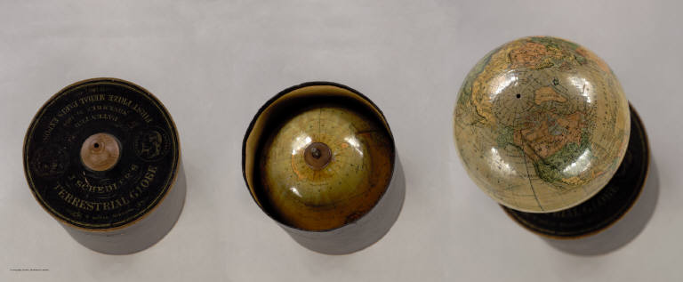
Author
Schedler, Joseph
Full Title
J. Schedler's Terrestrial Globe, 6 inches Diameter. Patented November 24 1868. Prize Medal Paris Expos. 1867. Clerks Office of the District Court of the Southern District of New York.
List No
2477.000
Note
The globe is stored in a cylindrical box, which also serves as a stand for the globe. Alaska is part of the U.S., indicating that the globe was up to date. One of the first globes to use gores produced by lithography (Warner).
Author
[Mitchell, Samuel Augustus, Young, James H.]
Full Title
(Covers to) Map Of The United States By J.H. Young. Published by S. Augustus Mitchell. Entered ... Pennsylvania, October 10th, 1831 by S. Augustus Mitchell. Engraved by J.H. Young, D. Haines & F. Dankworth. (inset) A Map Of North America Including All The Recent Geographical Discoveries. (with 10 additional inset maps).
List No
2723A
Author
[Mitchell, Samuel Augustus, Young, James H.]
Full Title
Map Of The United States By J.H. Young. Published by S. Augustus Mitchell. Entered ... Pennsylvania, October 10th, 1831 by S. Augustus Mitchell. Engraved by J.H. Young, D. Haines & F. Dankworth. (inset) A Map Of North America Including All The Recent Geographical Discoveries. (with 10 additional inset maps).
List No
2723.001
Note
1st edition, 1st wall map issued by Mitchell. This edition does not have the counties delineated and numbered. Ristow mistakenly says all editions have the townships (he means counties) numbered, but this one, the first, does not, thereby eliminating the index of counties and thus showing more of the western territory. This map predates the Traveler's Guide by 1 year, and thus is Mitchell's first "original" production, as opposed to the Finley material he reissued as the American Atlas and Pocket Maps. The case for the map has a leather label saying "Traveler's Map of the United States." Copyright date is October 10, 1831. There is no other date on the map. Ristow thinks the map was issued in early 1832, but it is not in Phillips until 1834 edition (which probably has the counties indicated by number and the 1831 copyright), so Ristow may not have seen this edition, but rather the 1834. The map is hand painted in bright full color by state (insets by county), dissected in 24 sections with green paper end sheets, mounted on linen and edged in pink silk. The covers 24x20 are half red leather marbled paper covered boards with ties and a leather label embossed with "Traveller's Map Of The United States" in gilt.
Author
Sotzmann, Daniel Friedrich
Full Title
Connecticut entworfen von D.F. Sotzmann. No. VI. Hamburg bey Carl Ernst Bohn 1796 ... P. Schmidt Sculp. zu Ebelings Erdbeschreibung von Amerika.
List No
2746.001
Note
In outline color by county.
Author
Sotzmann, Daniel Friedrich
Full Title
New Hampshire entworfen von D.F. Sotzmann. No. II. Hamburg bey Carl Ernst Bohn 1796 ... P. Schmidt Sculpsit. zu Ebelings Erdbeschreibung von Amerika. (inset map) Nordlicher Theil der Grafschast Grafton.
List No
2746.002
Note
Sotzmann used Holland and Belknap as sources. Full color by county.
Author
Sotzmann, Daniel Friedrich
Full Title
Pennsylvania entworfen von D.F. Sotzmann. No. IX. Hamburg bey Carl Ernst Bohn 1797. W. Sander Sc. zu Ebelings Erdbeschreibung von Amerika.
List No
2746.003
Note
Sotzmann used Howell as a source. Full color by county.
Author
Sotzmann, Daniel Friedrich
Full Title
Rhode Island entworfen von D.F. Sotzmann. No. V. Hamburg bey Carl Ernst Bohn 1797. ... gestochen von H. Kliewer. zu Ebelings Erdbeschreibung von Amerika.
List No
2746.004
Note
This was the largest scale map of the series. Full color by county.
Author
Sotzmann, Daniel Friedrich
Full Title
Vermont entworfen von D.F. Sotzmann. No. XVI. Hamburg bey Carl Ernst Bohn 1796. P. Schmidt Sc. zu Berlin. zu Ebelings Erdbeschreibung von Amerika.
List No
2746.005
Note
Sotzmann used Whitelaw and Blodget as sources. Full color by county.
Author
[Colton, J. H., Norman, B.M., Persac, A.]
Full Title
Norman's Chart Of The Lower Mississippi River By A. Persac. Published by B.M. Norman, New Orleans, La. 1858. Entered ... 1858 by B.M. Norman ... Louisiana. Engraved, Printed & Mounted By J.H. Colton & Co. New York. (At top) From Natchez to New Orleans.
List No
2752.000
Note
Views; shows Plantations by type; very scarce. In full color; lacks original covers. See our reproduction copy issued by Pelican Press, originally in 1931, and printed by Rand McNally - this reproduction greatly alters the original. Ritzlin catalogue: "Persac was a well known surveyor and landscape painter... the map is quite scarce and normally in poor condition because most copies were used by river pilots to locate plantation landings. Few copies are known in contemporary boards. NUC lists only three copies ... however several copies are located in the south, including one which the Louisiana Supreme Court still uses in land ownership cases." Incredible detail, showing the Plantations on both sides of the river. Four engraved views. Engraved by J.H. Colton. Lacking boards, this copy has some tears at the folds with slight loss at some intersections, some light browning in two areas, but is overall a very good copy. Copies at LSU, Historic New Orleans Collection (504-523-4662). See Antiques Magazine, Nov. 1991 for Persac Article. Norman also published "Norman's New Orleans and Environs" with a map of the city, in 1845 (see our copy).
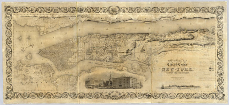
Author
Colton, J. H.
Full Title
Topographical Map Of The City and County Of New - York, and the adjacent Country: With Views in the border of the principal Buildings and interesting Scenery of the Island. Published By J.H. Colton & Co. No. 4 Spruce St. New-York. 1836. Engraved & Printed by S. Stiles & Company, New-York. Entered ... 1836, by J.H. Colton & Co. ... New York.
List No
2784.000
Note
1st ed., 2nd state. Stokes: "This is one of the most beautiful nineteenth century plans or maps of Manhattan Island, and is full of interesting information, It is perhaps the last example of really artistic map-making, as applied to Manhattan Island." Ristow believes that Burr may have drawn this map based on similarities between it and the Burr New York City map that appeared in Burr's New York State Atlas of 1829. Accompanied by the "Summary History.." Stokes describes his copy of the 1st edition as not listing Madison Square and some other differences between the 1836 and 1841 editions which would lead one to conclude that this copy is slightly later than 1836 (it shows Madison Square which was established in 1837) - apparently an unrecorded 2nd state of the first edition. Without color or top and bottom rollers.
Author
Mitchell, John
Full Title
A Map of the British and French Dominions in North America with the Roads, Distances, Limits and Extent of the Settlements.
List No
2842.000
Note
This is the second edition of this important map, dated 1755 but published in 1757, according to the British Museum. The only change from the first issue is the addition of several panels of interesting text in ocean. The original eight printed sheets of the map are here assembled in two large panels (each with four sheets) each dissected into 36 sections and mounted on linen. Uncolored, as issued. In the sixth line of the first column of the text this issue is referred to as the Second Edition One of the most important maps in American history, it went through five editions (see Stevens). We believe this second edition is scarcer than the other editions as it appears less often on the market. Compare to the first French edition of 1856 (our copy) regarding the conflicting claims of the British and French to American territory.
Author
[Bruff, J. Goldsborough, Disturnell, John]
Full Title
(Covers to) Army Map Of The Seat Of War In Virginia, Showing the Battle Fields, Fortifications, Etc. on & near the Potomac River. Drawn by J.G. Bruff. Published by J. Disturnell, New York And Hudson Taylor, Washn. D.C. 1862. Entered ... 1861, by John Disturnell ... New York. Lith. of P.S. Duval & Son, Philada.
List No
2846A
Author
[Bruff, J. Goldsborough, Disturnell, John]
Full Title
Army Map Of The Seat Of War In Virginia, Showing the Battle Fields, Fortifications, Etc. on & near the Potomac River. Drawn by J.G. Bruff. Published by J. Disturnell, New York And Hudson Taylor, Washn. D.C. 1862. Entered ... 1861, by John Disturnell ... New York. Lith. of P.S. Duval & Son, Philada.
List No
2846.001
Note
2nd edition, 1st was 1861. A beautiful production by Bruff, very detailed and well done. Major battles (Bull Run, etc.) near Washington are shown as well as fortifications around the capital. There is a list of 34 U.S. forts in the lower right. Map is folded into red cloth covers 15.5x11 with "Seat of War on the Potomac" stamped in gilt.
Author
Burritt, Elijah H.
Full Title
(Covers to) Atlas, Designed To Illustrate The Geography Of The Heavens ... By Elijah H. Burritt, A.M. New Edition. New York: Published By Huntington And Savage 216 Pearl Street. Entered ... 1835, by F.J. Huntington ... Connecticut.
List No
2853A
Author
Burritt, Elijah H.
Full Title
A Plan of the Solar System Exhibiting its Relative Magnitudes and Distances. Plate I. Hartford, Published by F.J. Huntington 1835, Entered according to Act of Congress Sepr. 1st 1835 by F.J. Huntington of the State of Connecticut. Engraved by W.G. Evans N. York, under the Direction of E.H. Burritt.
List No
2853.001
Note
Upper half of the pages shows the relative magnitudes of the planets along with a chart detailing relative diameters of the same. At the bottom left are a number of diagrams showing the comparative distances of the planets to the sun and the distances of the satellites from their planets. At the bottom right is a chart entitled, "Plan of the Solar System Exhibiting the relative Position of the Planets Orbits and their Inclination to the Plane of the Ecliptic." All uncolored.
Author
Burritt, Elijah H.
Full Title
(The constellations in) March, February, January (Pl. III), December, November, and October (Pl. II). Engraved by W.G. Evans N. York, under the Direction of E.H. Burritt. Hartford, Published by F.J. Huntington 1835. Entered according to act of Congress Septr. 1st 1835, by F.J. Huntington, of the State of Connecticut.
List No
2853.002
Note
The pages are numbered in such a way that Plate III precedes Plate II. The constellations are in full color. The stars are different sized depending upon their magnitude. In full color.
Author
Burritt, Elijah H.
Full Title
(The constellations in) September, August, July (Pl. V), June, May, April (Pl. IV). Engraved by W.G. Evans N. York, under the Direction of E.H. Burritt. Hartford, Published by F.J. Huntington 1835. Entered according to act of Congress Septr. 1st 1835, by F.J. Huntington, of the State of Connecticut.
List No
2853.003
Note
The pages are numbered in such a way that Plate V precedes Plate IV. The constellations are in full color. The stars are different sized depending upon their magnitude. In full color.
Author
Burritt, Elijah H.
Full Title
Southern Circumpolar Map for each Month of the Year. (Pl. VII.) Northern Circumpolar Map. (Pl. VI.) Engraved by W.G. Evans N. York, under the Direction of E.H. Burritt. Hartford, Published by F.J. Huntington 1835. Entered according to act of Congress Septr. 1st 1835, by F.J. Huntington, of the State of Connecticut.
List No
2853.004
Note
Maps in full color with an accompanying scale of magnitude for the stars.
Author
Burritt, Elijah H.
Full Title
A Celestial Planisphere, or Map of the Heavens. (Pl. VIII.) Engraved by W.G. Evans under the Direction of E.H. Burritt. Hartford, Published by F.J. Huntington 1835. Entered according to act of Congress Septr. 1st 1835, by F.J. Huntington, of the State of Connecticut.
List No
2853.005
Note
The color map includes a scale exhibiting the sun's place in the ecliptic every day of the year.
Author
Popple, Henry
Full Title
(Covers to) A Map of the British Empire in America with the French and Spanish Settlements adjacent thereto. by Henry Popple. C. Lempriere inv. & del. B Baron Sculp. To the Queen's Most Excellent Majesty This Map is most humbly Inscribed by Your Majesty's most Dutiful, most Obedient, and most Humble Servant Henry Popple. London Engrav'd by Willm. Henry Toms & R.W. Seale, 1733. (index map) ... W.H. Toms Sculp.
List No
2874A
Author
Popple, Henry
Full Title
America Septentrionalis. A Map of the British Empire in America with the French and Spanish Settlements adjacent thereto. by Henry Popple. To the Queen's Most Excellent Majesty This Map is most humbly Inscribed by Your Majesty's most Dutiful, most Obedient, and most Humble Servant Henry Popple. W.H. Toms Sculp.
List No
2874.001
Note
Index map in full color with numeric notations indicating location of the accompanying maps. With eighteen inset maps and four views (Fall of Niagara, Mexico [City], Quebec and New York). Note by Edmund Halley at the bottom verifies the accuracy of the map.
Author
Popple, Henry
Full Title
(Composite Map of) A Map of the British Empire in America with the French and Spanish Settlements adjacent thereto. by Henry Popple. C. Lempriere inv. & del. B Baron Sculp. To the Queen's Most Excellent Majesty This Map is most humbly Inscribed by Your Majesty's most Dutiful, most Obedient, and most Humble Servant Henry Popple. London Engrav'd by Willm. Henry Toms & R.W. Seale, 1733.
List No
2874.002
Note
A composite of all twenty sheets of the Popple Atlas. Sheets without color.
Author
Popple, Henry
Full Title
A Map of the British Empire in America with the French and Spanish Settlements adjacent thereto. by Henry Popple. (Sheet 1).
List No
2874.003
Note
Uncolored map with two large inset views of Niagara Falls and Mexico City. The view of Mexico City includes a reference list to the lettered locations shown. The "Heads of ye Missisipi" included.
|