|
Author
[Harrison, Robert H., Titus, Clarence O.]
Full Title
(Covers to) Titus' atlas of Hamilton Co., Ohio from actual surveys by R.H. Harrison, C.E. Assisted by Geo. E. Warner, A. Leavenworth, J.E. Sherman, L.C. Warner & R.T. Higgins, to which is added a township map of the state of Ohio. Also an outline & railroad map of the United States. Published by C.O. Titus. 320 Chestnut St., Philadelphia, 1869. Assistants T.F. Pratt, Cyrus Haven, H. Turner, G.P. Stevenson, J.H. Hall, D.B. Titus, G.M. Stevenson. Engd. by Worley & Bracher, 320 Chestnut St., Phila. Printed by F. Bourquin, 320 Chestnut St., Phila. Entered ... 1869 by C.O. Titus ... Pennsylvania.
List No
3748A
Note
The quarter leather dark brown cloth covers are titled "Atlas of Cincinnati and Hamilton Co. Ohio C.O. Titus." in gold.
Author
[Harrison, Robert H., Titus, Clarence O.]
Full Title
(Title Page to) Titus' atlas of Hamilton Co., Ohio from actual surveys by R.H. Harrison, C.E. Assisted by Geo. E. Warner, A. Leavenworth, J.E. Sherman, L.C. Warner & R.T. Higgins, to which is added a township map of the state of Ohio. Also an outline & railroad map of the United States. Published by C.O. Titus. 320 Chestnut St., Philadelphia, 1869. Assistants T.F. Pratt, Cyrus Haven, H. Turner, G.P. Stevenson, J.H. Hall, D.B. Titus, G.M. Stevenson. Engd. by Worley & Bracher, 320 Chestnut St., Phila. Printed by F. Bourquin, 320 Chestnut St., Phila. Entered ... 1869 by C.O. Titus ... Pennsylvania.
List No
3748B
Note
The quarter leather dark brown cloth covers are titled "Atlas of Cincinnati and Hamilton Co. Ohio C.O. Titus." in gold. There are ten detailed maps of Cincinnati. Colton's Ohio map is used without attribution and under Titus' imprint. The plans of towns and counties art typical for the period; no views, except for the last page which has two views and a description of Longview Asylum. Full color.
Author
[Harrison, Robert H., Titus, Clarence O.]
Full Title
(Contents to) Titus' atlas of Hamilton Co., Ohio from actual surveys by R.H. Harrison, C.E. Assisted by Geo. E. Warner, A. Leavenworth, J.E. Sherman, L.C. Warner & R.T. Higgins, to which is added a township map of the state of Ohio. Also an outline & railroad map of the United States. Published by C.O. Titus. 320 Chestnut St., Philadelphia, 1869. Assistants T.F. Pratt, Cyrus Haven, H. Turner, G.P. Stevenson, J.H. Hall, D.B. Titus, G.M. Stevenson. Engd. by Worley & Bracher, 320 Chestnut St., Phila. Printed by F. Bourquin, 320 Chestnut St., Phila. Entered ... 1869 by C.O. Titus ... Pennsylvania.
List No
3748C
Note
Table of contents.
Full Title
Table of distances of Hamilton County, Ohio. (1869)
List No
3748D
Note
"Giving the distances in miles and tenths of miles between towns, measured by the nearest public road."
Full Title
Outline township & section map of Hamilton County, Ohio. (1869)
List No
3748.001
Note
Hand col. lithographed map. Shows townships, cities, railroads, roads, etc. Includes explanation or legend for detailed maps.
Full Title
White Water. Miami. (1869)
List No
3748.002
Note
Hand col. lithographed map. Shows owners of large parcels, sections, canals, roads, railroads, etc.
Full Title
Cleves, Miami Township, Hamilton Co., O. (with) North Bend, Miami Township. (with) Miami Town, White Water Township. (with) Elizabethtown, River Dale P.O., White Water Township. (1869)
List No
3748.003
Note
Hand col. lithographed map with 3 inset maps. Shows lot numbers, owners of large parcels, buildings, railroad, etc. Includes business directories.
Full Title
Harrison, Harrison Township. Harrison (Township). (with) Springfield, Springfield Tp. (1869)
List No
3748.004
Note
Two hand col. lithographed maps with inset. Show lot numbers, sections, owners of large parcels, buildings, railroads, etc. Includes business directories.
Full Title
Crosby. (with) New Baltimore, Crosby Township. (with) New Haven, Crosby Township. (1869)
List No
3748.005
Note
Hand col. lithographed map with 2 insets. Includes business directory. Shows owners of large parcels, sections, roads, etc.; insets show lot numbers, buildings, ownership.
Full Title
Colerain. (with) Dunlap, Colerain Tp. (1869)
List No
3748.006
Note
Hand col. lithographed map with inset. Includes business directory. Shows owners of large parcels, sections, roads, railroads, etc. Scale of inset (1:9,900)
Full Title
Green. (1869)
List No
3748.007
Note
Hand col. lithographed map. Shows owners of large parcels, sections, roads, railroads, etc.
Full Title
River Side. (with) Delhi. (with) Home City, Delhi Subd'n, Industry. (1869)
List No
3748.008
Note
Hand col. lithographed map with 2 insets. Shows lot numbers, owners of large parcels, buildings, railroad, etc. Includes business directory.
Full Title
Storrs. (with) Cheviot, Green Township. (with) Plainville, Columbia Township. (1869)
List No
3748.009
Note
Hand col. lithographed map with 2 insets. Shows lot numbers, owners of large parcels, buildings, railroads, etc. Includes business directory.
Full Title
Springfield. (1869)
List No
3748.010
Note
Hand col. lithographed map. Shows owners of large parcels, sections, roads, railroads, etc.
Full Title
Glendale, Springfield Township. (with) Hartwell, Springfield Township. (with) Pleasant Ridge. (1869)
List No
3748.011
Note
Hand col. lithographed map with 2 insets. Shows lot numbers, owners of large parcels, buildings, railroad, etc. Includes business directories.
Full Title
Sycamore. (1869)
List No
3748.012
Note
Hand col. lithographed map. Shows owners of large parcels, sections, roads, railroads, etc.
Full Title
Lockland. Reading. (with) O'Bryonville, Spencer Township. (with) Pendleton, Spencer Township. (with) Camp Dennison, Symmes Township. (1869)
List No
3748.013
Note
Hand col. lithographed map with 3 insets. Shows lot numbers, owners of large parcels, buildings, railroad, canal, etc. Includes business directories.
Full Title
Columbia. (with) Camden City, Columbia Township. (with) Oakley, Columbia Township. (with) Montauk, Columbia Township. (1869)
List No
3748.014
Note
Hand col. lithographed map with 3 insets. Shows owners of large parcels, sections, roads, railroads, etc.
Full Title
Symmes. (with) Mount Pleasant, Springfield Township.(1869)
List No
3748.015
Note
Hand col. lithographed map with inset. Includes Mt. Pleasant business directory. Shows owners of large parcels, sections, roads, railroads, etc.
Full Title
Anderson. (1869)
List No
3748.016
Note
Hand col. lithographed map. Shows owners of large parcels, sections, roads, railroads, etc.
Full Title
Spencer. Madisonville, Columbia Township. (with) Sharpsburg, Columbia Township. (1869)
List No
3748.017
Note
Two hand col. lithographed maps with inset. Show owners of large parcels, sections, roads, railroads, lot numbers, buildings (in Madisonville, Sharpsburg), etc. Includes business directories.
Full Title
Columbia, Spencer Township. (with) Mount Washington. (1869)
List No
3748.018
Note
Hand col. lithographed map with inset. Shows lot numbers, owners of large parcels, buildings, railroad, etc. Includes business directory.
Full Title
Mill Creek. (with) Winton Place. (with) St. Peters, Lick Run, Mill Creek Township, Weaversburg. (1869)
List No
3748.019
Note
Hand col. lithographed map with 2 insets. Shows owners of large parcels, sections, roads, railroads, etc.
Full Title
Avondale, Mill Creek township. (with) Newton, Anderson Township. (with) Montgomery, Sycamore Township. (1869)
List No
3748.020
Note
Hand col. lithographed map with 2 insets. Shows lot numbers, owners of large parcels, buildings, etc. Includes business directories.
Full Title
Cumminsville, Mill Creek Township. (with) Carthage, Mill Creek Township. (with) New Burlington, Springfield Township. (1869)
List No
3748.021
Note
Hand col. lithographed map with 2 insets. Shows lot numbers, owners of large parcels, buildings, railroads, cemeteries, etc. Includes business directories.
Full Title
Corryville, Mill Creek Township (1869)
List No
3748.022
Note
Hand col. lithographed map. Shows block and lot numbers, owners of large parcels, buildings, etc. Includes business directory.
Full Title
Clifton, Mill Creek Township. (with) St. Bernard, Mill Creek Township. (1869)
List No
3748.023
Note
Hand col. lithographed map with inset. Shows lot size, owners of large parcels, buildings, etc.
Full Title
Walnut Hills, Mill Creek Township. (with) California, Anderson Township. (1869)
List No
3748.024
Note
Hand col. lithographed map with inset. Shows block lot numbers, owners of large parcels, buildings, railroad, etc. Includes business directories.
Full Title
Camp Washington and Clifton Heights. (1869)
List No
3748.025
Note
Hand col. lithographed map. Shows lot numbers, owners of large parcels, buildings, etc.
Full Title
College Hill, Mill Creek Tp. (with) Sharon. (1869)
List No
3748.026
Note
Hand col. lithographed map with inset. Shows lot numbers, owners of large parcels, buildings, railroad, etc. Includes business directories.
Full Title
Fairmount, Mt. Harrison & vicinity, Mill Creek Township. (1869)
List No
3748.027
Note
Hand col. lithographed map. Shows lot numbers, buildings, cemeteries, parks, railroad, owners of large parcels, etc.
Full Title
Outline map of Cincinnati. Accompanying Atlas of Cincinnati & Hamilton Co. (1869)
List No
3748.028
Note
Hand col. lithographed map. Shows wards, streets, railroads, etc. Includes lists of fire alarm signal boxes and school buildings, and church directory.
Full Title
Cincinnati part I embracing 16th wards. (1869)
List No
3748.029
Note
Hand col. lithographed map. Shows numbers, tracts, owners of large parcels, major buildings, railroads, park, etc.
Full Title
Cincinnati part II embracing 6th, 8th & 15th wards. (1869)
List No
3748.030
Note
Hand col. lithographed map. Shows numbers, tracts, owners of large parcels, major buildings, railroads, etc.
Full Title
Cincinnati part VI embracing 2nd, 4th & 14th wards. (1869)
List No
3748.031
Note
Hand col. lithographed map. Shows numbers, tracts, owners of large parcels, major buildings, railroads, etc.
Full Title
Cincinnati part V embracing 1st & 3d wards. (1869)
List No
3748.032
Note
Hand col. lithographed map. Shows numbers, tracts, owners of large parcels, major buildings, railroads, Cincinnati Observatory, etc.
Full Title
Cincinnati part VI embracing 9th & 13th wards. (1869)
List No
3748.033
Note
Hand col. lithographed map. Shows numbers, tracts, owners of large parcels, major buildings, canal, courthouse, jail, Woodward High School, etc.
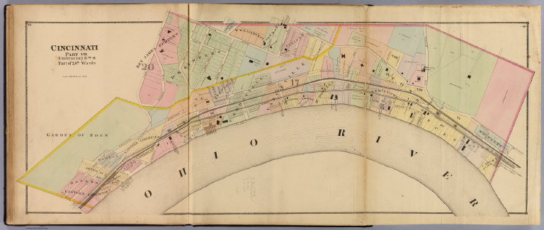
Full Title
Cincinnati part VII embracing 17th & part of 20th wards. (1869)
List No
3748.034
Note
Hand col. lithographed map. Shows numbers, tracts, owners of large parcels, major buildings, railroads, etc. David Rumsey Collection copy has annotation in pencil.
Full Title
Cincinnati part VIII embracing part of 20th ward. Cincinnati part III embracing 5th, 7th & 10th wards. (1869)
List No
3748.035
Note
Two hand col. lithographed maps on 1 sheet. Shows numbers, tracts, owners of large parcels, major buildings, canal, etc. David Rumsey Collection copy has annotation in pencil.
Full Title
Cincinnati part IX embracing 11th & 19th wards. (1869)
List No
3748.036
Note
Two hand col. lithographed maps on 1 sheet. Shows numbers, tracts, owners of large parcels, major buildings, etc.
Full Title
Cincinnati part X embracing 12th & 18th wards. (1869)
List No
3748.037
Note
Two hand col. lithographed maps on 1 sheet. Shows numbers, tracts, owners of large parcels, major buildings, railroad, canal, etc.
Author
Titus, Clarence O.
Full Title
Titus' railroad & township map of the state of Ohio. (with view) State Capitol at Columbus. Published by C.O. Titus, 320 Chestnut St., Philadelphia, Pa. (1869)
List No
3748.038
Note
Hand col. lithographed map. Shows counties and townships, railroads, canals, post roads, etc. Prime meridians: Greenwich and Washington. "Colton's Ohio map is used without attribution and under Titus' imprint"--David Rumsey Collection catalog.
Full Title
Longview Asylum near Cincinnati, Ohio. Longview Asylum, colored. (1869)
List No
3748.040
Note
Two views surrounded on 3 sides by descriptive text. List of directors and officers at head of text. "The lower cut represents a handsome and convenient edifice which stands on the Carthage Pike, about forty rods west and opposite the main building, and is used for the accommodation of colored patients."
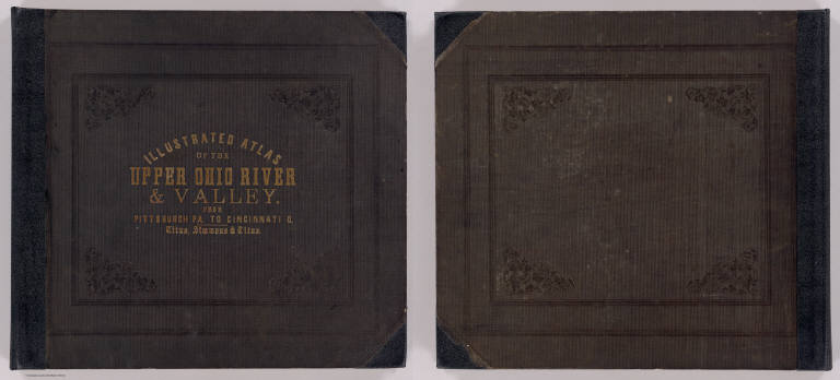
Author
Hayes, Eli L.
Full Title
(Covers to) Illustrated atlas of the Upper Ohio River and Valley from Pittsburgh, Pa. to Cincinnati, Ohio. From United States official and special surveys compiled & drawn for the publishers by E.L. Hayes, assisted by E.F. Hayes, C.M. Beresford, assisted by S.A. Charpiot, F.L. Sanford, J.H. Sherman. Published by Titus, Simmons & Titus, 27 South Sixth Street Phila. 1877. Eng. by Worley & Bracher, 27 So. Sixth St. Phila, Pa. Printed by H.J. Toudy & Co. 623 Commerce St. Phila, Pa. Oldach & Mergenthaler Binders, S.E. Cor. 4th & Cherry Sts. Phila. Entered ... 1877, by Titus Simmons & Titus ... Washington. (view by) A. Ruger, del ...
List No
4975A
Note
This is perhaps the most extraordinary "county atlas" produced in the 19th century. Although it is a regional atlas in scope, covering both sides of the Ohio River from Pittsburgh to Cincinnati, in format it is county atlas with views, maps, and advertising directories of the local towns, cities, residences, and businesses along the river. There are 26 double page maps of the Ohio River, plus an index sheet, that are beautifully drawn and colored, as well as numerous maps of towns and cities on the river. The views frequently show the river and river boat traffic, the inside and outside of factories (an inside view of a glass blowing factory is amazing), and farms and residences. There are large fold out maps of Pittsburgh and Cincinnati. When taken all together, the effect is stunning. This atlas has become rare, with few copies surviving the "breaker's" temptation to cut it up. Rieger rates it "of extraordinary importance" and "extremely scarce." Bound in half leather dark brown cloth covered boards with "Illustrated Atlas Of The Upper Ohio River & Valley. From Pittsburgh Pa. To Cincinnati O. Titus, Simmons & Titus." stamped in gold. Full and outline color.
Author
Hayes, Eli L.
Full Title
(Title Page to) Illustrated atlas of the Upper Ohio River and Valley from Pittsburgh, Pa. to Cincinnati, Ohio. From United States official and special surveys compiled & drawn for the publishers by E.L. Hayes, assisted by E.F. Hayes, C.M. Beresford, assisted by S.A. Charpiot, F.L. Sanford, J.H. Sherman. Published by Titus, Simmons & Titus, 27 South Sixth Street Phila. 1877. Eng. by Worley & Bracher, 27 So. Sixth St. Phila, Pa. Printed by H.J. Toudy & Co. 623 Commerce St. Phila, Pa. Oldach & Mergenthaler Binders, S.E. Cor. 4th & Cherry Sts. Phila. Entered ... 1877, by Titus Simmons & Titus ... Washington. (view by) A. Ruger, del ...
List No
4975B
Note
Includes "View on the Ohio River taken from near East Liverpool, embracing parts of Ohio, West Virginia & Pennsylvania, A. Ruger del." This is perhaps the most extraordinary "county atlas" produced in the 19th century. Although it is a regional atlas in scope, covering both sides of the Ohio River from Pittsburgh to Cincinnati, in format it is county atlas with views, maps, and advertising directories of the local towns, cities, residences, and businesses along the river. There are 26 double page maps of the Ohio River, plus an index sheet, that are beautifully drawn and colored, as well as numerous maps of towns and cities on the river. The views frequently show the river and river boat traffic, the inside and outside of factories (an inside view of a glass blowing factory is amazing), and farms and residences. There are large fold out maps of Pittsburgh and Cincinnati. When taken all together, the effect is stunning. This atlas has become rare, with few copies surviving the "breaker's" temptation to cut it up. Rieger rates it "of extraordinary importance" and "extremely scarce." Bound in half leather dark brown cloth covered boards with "Illustrated Atlas Of The Upper Ohio River & Valley. From Pittsburgh Pa. To Cincinnati O. Titus, Simmons & Titus." stamped in gold. Full and outline color.
Author
Hayes, Eli L.
Full Title
(Contents to) Illustrated atlas of the Upper Ohio River and Valley from Pittsburgh, Pa. to Cincinnati, Ohio. From United States official and special surveys compiled & drawn for the publishers by E.L. Hayes, assisted by E.F. Hayes, C.M. Beresford, assisted by S.A. Charpiot, F.L. Sanford, J.H. Sherman. Published by Titus, Simmons & Titus, 27 South Sixth Street Phila. 1877. Eng. by Worley & Bracher, 27 So. Sixth St. Phila, Pa. Printed by H.J. Toudy & Co. 623 Commerce St. Phila, Pa. Oldach & Mergenthaler Binders, S.E. Cor. 4th & Cherry Sts. Phila. Entered ... 1877, by Titus Simmons & Titus ... Washington. (view by) A. Ruger, del ...
List No
4975C
Note
This is perhaps the most extraordinary "county atlas" produced in the 19th century. Although it is a regional atlas in scope, covering both sides of the Ohio River from Pittsburgh to Cincinnati, in format it is county atlas with views, maps, and advertising directories of the local towns, cities, residences, and businesses along the river. There are 26 double page maps of the Ohio River, plus an index sheet, that are beautifully drawn and colored, as well as numerous maps of towns and cities on the river. The views frequently show the river and river boat traffic, the inside and outside of factories (an inside view of a glass blowing factory is amazing), and farms and residences. There are large fold out maps of Pittsburgh and Cincinnati. When taken all together, the effect is stunning. This atlas has become rare, with few copies surviving the "breaker's" temptation to cut it up. Rieger rates it "of extraordinary importance" and "extremely scarce." Bound in half leather dark brown cloth covered boards with "Illustrated Atlas Of The Upper Ohio River & Valley. From Pittsburgh Pa. To Cincinnati O. Titus, Simmons & Titus." stamped in gold. Full and outline color.
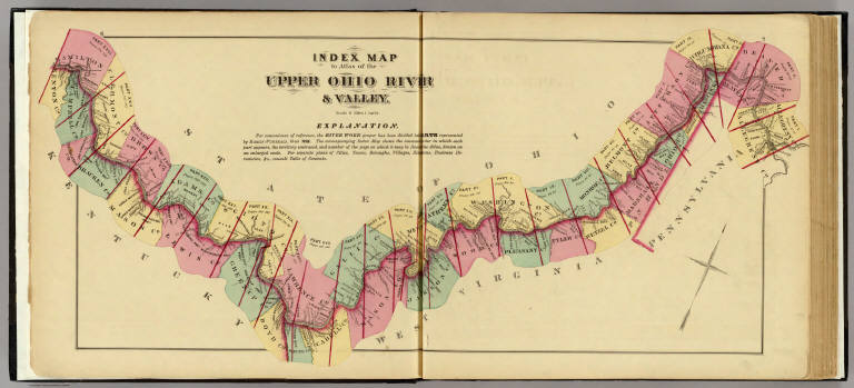
Author
Hayes, Eli L.
Full Title
Index map to Atlas of the Upper Ohio River & Valley. (... compiled & drawn for the publishers by E.L. Hayes, assisted by E.F. Hayes, C.M. Beresford, assisted by S.A. Charpiot, F.L. Sanford, J.H. Sherman. Published by Titus, Simmons & Titus ... Phila. 1877. Eng. by Worley & Bracher ... Printed by H.J. Toudy & Co. ... Oldach & Mergenthaler Binders ...)
List No
4975.002
Note
Lithograph. Counties hand col. Includes "Explanation."
Author
Hayes, Eli L.
Full Title
Upper Ohio River and Valley part III, 32 to 46 miles below Pittsburgh, 421 to 435 miles above Cincinnati. (with) Smiths Ferry ... (with) Glasgow ... (with) Industry ... (all) Beaver Co., Pa. (or Penna.) (... compiled & drawn for the publishers by E.L. Hayes, assisted by E.F. Hayes, C.M. Beresford, assisted by S.A. Charpiot, F.L. Sanford, J.H. Sherman. Published by Titus, Simmons & Titus ... Phila. 1877. Eng. by Worley & Bracher ... Printed by H.J. Toudy & Co. ... Oldach & Mergenthaler Binders ...)
List No
4975.024
Note
Hand col. lithograph. Shows buildings, landowners, townships, etc. Inset maps variously show buildings, lots, etc. Glasgow and Industry maps at (1:4,800) scale; Smiths Ferry at (1:3,960).
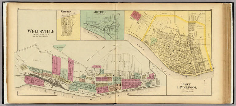
Author
Hayes, Eli L.
Full Title
Wellsville, Columbiana Co., O. (with) Jethro ... (with) East Liverpool ... (both) Columbiana Co., O. (with) Hamilton, Hancock Co., W. Va. (... compiled & drawn for the publishers by E.L. Hayes, assisted by E.F. Hayes, C.M. Beresford, assisted by S.A. Charpiot, F.L. Sanford, J.H. Sherman. Published by Titus, Simmons & Titus ... Phila. 1877. Eng. by Worley & Bracher ... Printed by H.J. Toudy & Co. ... Oldach & Mergenthaler Binders ...)
List No
4975.027
Note
Hand col. lithograph with 3 inset maps. Show buildings, landowners, lots numbers, tracts, etc. Scales of insets vary.
Author
Hayes, Eli L.
Full Title
Ohio Valley Pottery, Laughlin Brothers ... (with) C.C. Thompson & Co. manufacturers of Rochingham White Lined & Yellow Queens Ware ... (both) East Liverpool, Ohio. (... compiled & drawn for the publishers by E.L. Hayes, assisted by E.F. Hayes, C.M. Beresford, assisted by S.A. Charpiot, F.L. Sanford, J.H. Sherman. Published by Titus, Simmons & Titus ... Phila. 1877 ... Printed by H.J. Toudy & Co. ... Oldach & Mergenthaler Binders ...)
List No
4975.028
Note
Two lithographed views on 1 sheet.
|