|
Author
Polish Army Topography Service
Full Title
Early World Maps. Pergamon World Atlas.
List No
0737.014
Note
Small facsimile images of seventeen "world" maps from Babylonian period to 1870.
Author
Polish Army Topography Service
Full Title
Early World Maps (continued). Astronomy - Galaxies. Pergamon World Atlas.
List No
0737.015
Note
Small facsimile images of six "world" maps from 1526 to 1843. Images of galaxies.
Author
Polish Army Topography Service
Full Title
Astronomy - Planets (and sun). Pergamon World Atlas.
List No
0737.016
Note
Images of planets, sun.
Author
Polish Army Topography Service
Full Title
Astronomy - the Moon. The Atmosphere. Pergamon World Atlas.
List No
0737.017
Note
Consisting of eight lunar perspectives and six diagrams of atmospheric attributes.
Author
Polish Army Topography Service
Full Title
Constitution of the Earth. Pergamon World Atlas.
List No
0737.018
Note
Includes geologic time scale and numerous diagrams and maps about geology and geophysics of the earth.
Author
Polish Army Topography Service
Full Title
World-Physical. Land Hemisphere. Water Hemisphere. Magnetic Declination, Land Hemisphere (1965). Antipodes. Magnetic Declination, Water Hemisphere (1965). Pergamon World Atlas. Pergamon Press, Ltd. & P.W.N. Poland 1967. Sluzba Topograficzna W.P.
List No
0737.019
Note
Land and water hemispheres centered on France and New Zealand, respectively. Five maps, three of which at 1:180,000,000.
Author
Polish Army Topography Service
Full Title
Geology. Tectonics. Pergamon World Atlas. Pergamon Press, Ltd. & P.W.N. Poland 1967. Sluzba Topograficzna W.P.
List No
0737.020
Note
Two maps. Lands classified by geologic periods. Tectonic features in 33 categories, both continental and oceanic.
Author
Polish Army Topography Service
Full Title
Quaternary. Geomorphology. Pergamon World Atlas. Pergamon Press, Ltd. & P.W.N. Poland 1967. Sluzba Topograficzna W.P.
List No
0737.021
Note
Two maps. Includes maximum extent of ice sheets and mountain glaciation. Shows various types of deposits such as glacial, fluvial, marine, and colluvial. Geomorphology map provides landforms such as loess, sedimentary plateaus, volcanic rocks, alpine mountains, etc.
Author
Polish Army Topography Service
Full Title
Atmoshperic Pressure, Thunderstorms, and Winds. Temperature. Pergamon World Atlas. Pergamon Press, Ltd. & P.W.N. Poland 1967. Sluzba Topograficzna W.P.
List No
0737.022
Note
Six maps showing atmospheric pressure, thunderstorms, and winds at 1:240,000,000. Three temperature maps at 1:180,000,000.
Author
Polish Army Topography Service
Full Title
Precipitation, Insolation, Evaporation. Precipitation Regimes, Climatic Zones. Pergamon World Atlas. Pergamon Press, Ltd. & P.W.N. Poland 1967. Sluzba Topograficzna W.P.
List No
0737.023
Note
Five maps showing mean annual values and climatic zones.
Author
Polish Army Topography Service
Full Title
Vegetation. Zoogeography. Pergamon World Atlas. Pergamon Press, Ltd. & P.W.N. Poland 1967. Sluzba Topograficzna W.P.
List No
0737.024
Note
Five maps. Vegetation includes main types and the natural vegetable productivity of the biosphere. Three zoological maps at 1:180,000,000; one map includes the diminution of the range of various species.
Author
Polish Army Topography Service
Full Title
Soils. Pergamon World Atlas. Pergamon Press, Ltd. & P.W.N. Poland 1967. Sluzba Topograficzna W.P.
List No
0737.025
Note
Uses 32 soils classes.
Author
Polish Army Topography Service
Full Title
Hydrography. Pergamon World Atlas. Pergamon Press, Ltd. & P.W.N. Poland 1967. Sluzba Topograficzna W.P.
List No
0737.026
Note
Shows runoff, rivers, and tidal range.
Author
Polish Army Topography Service
Full Title
World - Political (1.1.1967). Pergamon World Atlas. Pergamon Press, Ltd. & P.W.N. Poland 1967. Sluzba Topograficzna W.P.
List No
0737.027
Note
Polish Army Topographical Service Projection.
Author
Polish Army Topography Service
Full Title
Population. Pergamon World Atlas. Pergamon Press, Ltd. & P.W.N. Poland 1967. Sluzba Topograficzna W.P.
List No
0737.028
Note
Six maps of attributes of population: races, languages, growth, urbanization, and agricultural employment.
Author
Polish Army Topography Service
Full Title
Population Density. Pergamon World Atlas. Pergamon Press, Ltd. & P.W.N. Poland 1967. Sluzba Topograficzna W.P.
List No
0737.029
Note
Includes emigration from Europe 1820-1963.
Author
Polish Army Topography Service
Full Title
Economic Regions. Pergamon World Atlas. Pergamon Press, Ltd. & P.W.N. Poland 1967. Sluzba Topograficzna W.P.
List No
0737.030
Note
Economic regions based on GNP, agricultural production, industrial production, populated places, and population density.
Author
Polish Army Topography Service
Full Title
International Trade. Pergamon World Atlas. Pergamon Press, Ltd. & P.W.N. Poland 1967. Sluzba Topograficzna W.P.
List No
0737.031
Note
Shows imports and exports by broad commodity categories.
Author
Polish Army Topography Service
Full Title
Land Use. Pergamon World Atlas. Pergamon Press, Ltd. & P.W.N. Poland 1967. Sluzba Topograficzna W.P.
List No
0737.032
Note
Land use in six categories: arable, pasture, tropical grazing, some grazing, forest, and non-agricultural lands.
Author
Polish Army Topography Service
Full Title
Types of Agriculture. Pergamon World Atlas. Pergamon Press, Ltd. & P.W.N. Poland 1967. Sluzba Topograficzna W.P.
List No
0737.033
Note
Based on nineteen categories of agricultural land use.
Author
Polish Army Topography Service
Full Title
Agriculture. Pergamon World Atlas. Pergamon Press, Ltd. & P.W.N. Poland 1967. Sluzba Topograficzna W.P.
List No
0737.034
Note
Six agricultural maps: land and property ownership, farm size, artificial fertilizers and tractors, bread grains, rice, and barley and oats.
Author
Polish Army Topography Service
Full Title
Agriculture (continued). Pergamon World Atlas. Pergamon Press, Ltd. & P.W.N. Poland 1967. Sluzba Topograficzna W.P.
List No
0737.035
Note
Six agricultural maps: sucrose plants, oleaginous plants, fibros plants, viticulture and wine production, fruit growing, and stimulants and condiments.
Author
Polish Army Topography Service
Full Title
Agriculture (continued). Pergamon World Atlas. Pergamon Press, Ltd. & P.W.N. Poland 1967. Sluzba Topograficzna W.P.
List No
0737.036
Note
Six agricultural maps: tuberous plants, cattle, pigs, sheep and goats, draught and pack animals, and types of animal husbandry..
Author
Polish Army Topography Service
Full Title
Agriculture. Pergamon World Atlas. Pergamon Press, Ltd. & P.W.N. Poland 1967. Sluzba Topograficzna W.P.
List No
0737.037
Note
Three agricultural maps: forests, production of wood products, and fishing.
Author
Polish Army Topography Service
Full Title
Water Economics. Pergamon World Atlas. Pergamon Press, Ltd. & P.W.N. Poland 1967. Sluzba Topograficzna W.P.
List No
0737.038
Note
Shows water utilization for agriculture and power, and general water availability compared with aridity.
Author
Polish Army Topography Service
Full Title
Industry. Pergamon World Atlas. Pergamon Press, Ltd. & P.W.N. Poland 1967. Sluzba Topograficzna W.P.
List No
0737.039
Note
Six maps of industry: employment in industry and mining, electricity production, power production potential, solid fuel production, and petroleum, natural gas and refining capacity.
Author
Polish Army Topography Service
Full Title
Industry - Steel Production. Pergamon World Atlas. Pergamon Press, Ltd. & P.W.N. Poland 1967. Sluzba Topograficzna W.P.
List No
0737.040
Note
Shows steel production per capita and overall output of various metals. Includes main movements of iron ore.
Author
Polish Army Topography Service
Full Title
Industry. Pergamon World Atlas. Pergamon Press, Ltd. & P.W.N. Poland 1967. Sluzba Topograficzna W.P.
List No
0737.041
Note
Three maps with insets of Europe show industrial production of: titanium, bauxite and aluminum; copper, tin and cadmium; and zinc and lead.
Author
Polish Army Topography Service
Full Title
Industry (continued). Pergamon World Atlas. Pergamon Press, Ltd. & P.W.N. Poland 1967. Sluzba Topograficzna W.P.
List No
0737.042
Note
Has six maps: precious metals and mercury; beryl, collumbite-tantalite, selenium and zircon; diamonds, abrasive and insulating substances; natural and synthetic rubber and tires; sulpher, phosphastes, potash salts and saltpeter; supheric acid, nitrogenous fertilizers, caustic soda and plastics.
Author
Polish Army Topography Service
Full Title
Industry (continued). Pergamon World Atlas. Pergamon Press, Ltd. & P.W.N. Poland 1967. Sluzba Topograficzna W.P.
List No
0737.043
Note
Has three maps: cement; machine tools; and motor vehicles and ships launched.
Author
Polish Army Topography Service
Full Title
Surface Communications and Time Zones. Pergamon World Atlas. Pergamon Press, Ltd. & P.W.N. Poland 1967. Sluzba Topograficzna W.P.
List No
0737.044
Note
Shows transport by mode, quantities of materials handled by ports, and time zones.
Author
Polish Army Topography Service
Full Title
Air Communications. Telecommunications, Tourism. Pergamon World Atlas. Pergamon Press, Ltd. & P.W.N. Poland 1967. Sluzba Topograficzna W.P.
List No
0737.045
Note
Two maps showing air routes and volumes. Three maps showing: telecommunications; radio and television; and international tourism.
Author
Polish Army Topography Service
Full Title
Education, Food Supply. Pergamon World Atlas. Pergamon Press, Ltd. & P.W.N. Poland 1967. Sluzba Topograficzna W.P.
List No
0737.046
Note
Two maps show literacy rates and caloric sufficiency.
Author
Polish Army Topography Service
Full Title
National Income. Pergamon World Atlas. Pergamon Press, Ltd. & P.W.N. Poland 1967. Sluzba Topograficzna W.P.
List No
0737.047
Note
Two maps show income per capita, and growth of national income as an average annual percentage (1955-1965).
Author
Polish Army Topography Service
Full Title
North Atlantic. Pergamon World Atlas. Pergamon Press, Ltd. & P.W.N. Poland 1967. Sluzba Topograficzna W.P.
List No
0737.048
Note
Shows shipping lanes and distances, ports, bathymetry and topography.
Author
Polish Army Topography Service
Full Title
Atlantic Ocean. Antarctica. Pergamon World Atlas. Pergamon Press, Ltd. & P.W.N. Poland 1967. Sluzba Topograficzna W.P.
List No
0737.049
Note
Shows ocean currents, bathymetry, and topography. Antarctica map at 1:20,000,000 shows routes of scientific expeditions before 1957, bathymetry, topography, and ownership.
Author
Polish Army Topography Service
Full Title
The Arctic. Pergamon World Atlas. Pergamon Press, Ltd. & P.W.N. Poland 1967. Sluzba Topograficzna W.P.
List No
0737.050
Note
Shows routes of scientific expeditions before 1957, bathymetry, and topography.
Author
Polish Army Topography Service
Full Title
Atlantic Ocean. Atlantic Ocean - Islands. Pergamon World Atlas. Pergamon Press, Ltd. & P.W.N. Poland 1967. Sluzba Topograficzna W.P.
List No
0737.051
Note
Numerous small maps and diagrams of physical attributes of sea water by geographical distribution and depth. Also shows fishing grounds. Islands include Spitsbergen, Jan Mayan, Bear, Bermuda, Guadeloupe, Martinique, Madeira, Tenefrie, Gran Canaria, Canary Islands, Terceira, Sao Miguel, and Azores.
Author
Polish Army Topography Service
Full Title
Europe - Physical. Pergamon World Atlas. Pergamon Press, Ltd. & P.W.N. Poland 1967. Sluzba Topograficzna W.P.
List No
0737.052
Note
One large and three small maps. Topography and bathymetry in larger scale. Small maps of climate.
Author
Polish Army Topography Service
Full Title
Europe. Pergamon World Atlas. Pergamon Press, Ltd. & P.W.N. Poland 1967. Sluzba Topograficzna W.P.
List No
0737.053
Note
Four maps showing geology, geomorphology, soils, and vegetation.
Author
Polish Army Topography Service
Full Title
Europe. Pergamon World Atlas. Pergamon Press, Ltd. & P.W.N. Poland 1967. Sluzba Topograficzna W.P.
List No
0737.054
Note
Two maps showing mineral resources and land use.
Author
Polish Army Topography Service
Full Title
Europe. Pergamon World Atlas. Pergamon Press, Ltd. & P.W.N. Poland 1967. Sluzba Topograficzna W.P.
List No
0737.055
Note
Two maps showing communications including roads, seaport traffic, river port traffic, railways, inland waterways, train ferries, car ferries, and airport traffic.
Author
Polish Army Topography Service
Full Title
Western Europe. Pergamon World Atlas. Pergamon Press, Ltd. & P.W.N. Poland 1967. Sluzba Topograficzna W.P.
List No
0737.056
Note
Detailed physical and political map. Includes shipping lanes.
Author
Polish Army Topography Service
Full Title
Europe. Pergamon World Atlas. Pergamon Press, Ltd. & P.W.N. Poland 1967. Sluzba Topograficzna W.P.
List No
0737.057
Note
Five maps. Political Europe in 1914, 1937, and 1967; languages; and population density.
Author
Polish Army Topography Service
Full Title
Central Europe. Pergamon World Atlas. Pergamon Press, Ltd. & P.W.N. Poland 1967. Sluzba Topograficzna W.P.
List No
0737.058
Note
Detailed physical and political double-fold map.
Author
Polish Army Topography Service
Full Title
Poland. Pergamon World Atlas. Pergamon Press, Ltd. & P.W.N. Poland 1967. Sluzba Topograficzna W.P.
List No
0737.059
Note
Twenty small maps and graphs showing details about Poland including war damage 1939-1945, Polish migration 1945-1950, population density, other population attributes, employment, agriculture, climate, and land use.
Author
Polish Army Topography Service
Full Title
Poland - South. (inset) Walbrzych. (inset) Upper Silesian Basin. Pergamon World Atlas. Pergamon Press, Ltd. & P.W.N. Poland 1967. Sluzba Topograficzna W.P.
List No
0737.062
Note
Detailed physical and political map.
Author
Polish Army Topography Service
Full Title
Poland. Pergamon World Atlas. Pergamon Press, Ltd. & P.W.N. Poland 1967. Sluzba Topograficzna W.P.
List No
0737.063
Note
Twenty urban vicinity maps of Polish cities: Warzawa, Lodz, Poznan, Bydgoszcz, Torun, Lublin, Radom, Wroclaw, Krakow, Szczecin, Gdansk-Gdynia, Koszaun, Kielce, Olsztyn, Kielce, Bialystok, Sudety, Zielona Gora, Opole, Rzeszow, and Czestochowa.
Author
Polish Army Topography Service
Full Title
Poland. Pergamon World Atlas. Pergamon Press, Ltd. & P.W.N. Poland 1967. Sluzba Topograficzna W.P.
List No
0737.064
Note
Four maps of Polish areas: Gdansk Coastal Area, Koszalin Coastal Area, Szczecin Lagoon, and Great Masurian Lakes.
Author
Polish Army Topography Service
Full Title
Poland. Pergamon World Atlas. Pergamon Press, Ltd. & P.W.N. Poland 1967. Sluzba Topograficzna W.P.
List No
0737.065
Note
Five maps of urban vicinity maps: Lubuskie Lakeland, Warsaw Region, Swietokrzyskie Mountains, Krakow Region, and Tatra Mountains.
Author
Polish Army Topography Service
Full Title
Czechoslovakia. (inset) Brno. (inset) Ostrava. (inset) Praha (Prague). (inset) Bratislava. Pergamon World Atlas. Pergamon Press, Ltd. & P.W.N. Poland 1967. Sluzba Topograficzna W.P.
List No
0737.068
Note
Insets are vicinity maps. Detailed physical and political map.
Author
Polish Army Topography Service
Full Title
Czechoslovakia, German Democratic Republic. Pergamon World Atlas. Pergamon Press, Ltd. & P.W.N. Poland 1967. Sluzba Topograficzna W.P.
List No
0737.069
Note
Eight detailed maps of Erzgebirge, Elbe Gorge, Liberec Region, Berlin, Postock, Thuringia, Leipzig, and The Harz.
Author
Polish Army Topography Service
Full Title
Northern Europe. Pergamon World Atlas. Pergamon Press, Ltd. & P.W.N. Poland 1967. Sluzba Topograficzna W.P.
List No
0737.080
Note
Detailed political and physical map.
Author
Polish Army Topography Service
Full Title
Norway, Sweden, Finland. Pergamon World Atlas. Pergamon Press, Ltd. & P.W.N. Poland 1967. Sluzba Topograficzna W.P.
List No
0737.081
Note
Sixteen small maps and graphics including types of relief, population density, land use, population, agriculture, employment, mineral resources, power, forestry, industry, and foreign trade.
Author
Polish Army Topography Service
Full Title
England, Wales, and Ireland. Pergamon World Atlas. Pergamon Press, Ltd. & P.W.N. Poland 1967. Sluzba Topograficzna W.P.
List No
0737.090
Note
Detailed political and physical double-fold map.
Author
Polish Army Topography Service
Full Title
Scotland. England and Wales. Pergamon World Atlas. Pergamon Press, Ltd. & P.W.N. Poland 1967. Sluzba Topograficzna W.P.
List No
0737.091
Note
Detailed political and physical double-fold map. Maps of Lake District and Snowdonia at 1:250,000.
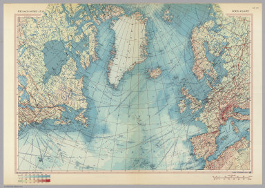
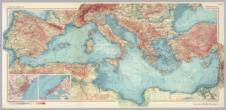
Author
Polish Army Topography Service
Full Title
Mediterranean Sea. (inset) Barcelona. (inset) El Iskandariya (Alexandria). Pergamon World Atlas. Pergamon Press, Ltd. & P.W.N. Poland 1967. Sluzba Topograficzna W.P.
List No
0737.096
Note
Detailed political and physical double-fold map.
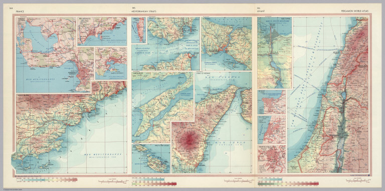
Author
Polish Army Topography Service
Full Title
France. Mediterranean Straits. Levant. Pergamon World Atlas. Pergamon Press, Ltd. & P.W.N. Poland 1967. Sluzba Topograficzna W.P.
List No
0737.097
Note
Double-fold map shows three areas in detail: (1) France has 1:500,000 locales of Cote d'Azur, Marseille (Marseilles), Nice, (and) Monaco, French Riviera, and Toulon; (2) Mediterranean Straits has 1:500,000 Gibraltar, Strait of Gibraltar, Dardanelles, Malta and Gozo, Strait of Messina, and Bosporus (Istanbul); and (3) Levant has varying scales including Tel-Aviv-Fayo, Beyrout (Beirut), Suez Canal, and Yerushalayim, El Quds (Jerusalem).
Author
Polish Army Topography Service
Full Title
Italy. (inset) Palermo. (inset) Venezia (Venice). Pergamon World Atlas. Pergamon Press, Ltd. & P.W.N. Poland 1967. Sluzba Topograficzna W.P.
List No
0737.102
Note
Detailed political and physical map.
Author
Polish Army Topography Service
Full Title
Italy. Pergamon World Atlas. Pergamon Press, Ltd. & P.W.N. Poland 1967. Sluzba Topograficzna W.P.
List No
0737.103
Note
Shows six small maps and graphics of industry, tourism, and foreign trade. Includes five urban vicinity maps: Napoli (Naples), Roma (Rome), Genova (Genoa), Torino (Turin), and Milano (Milan).
Author
Polish Army Topography Service
Full Title
Switzerland. Pergamon World Atlas. Pergamon Press, Ltd. & P.W.N. Poland 1967. Sluzba Topograficzna W.P.
List No
0737.104
Note
Detailed political and physical map.
Author
Polish Army Topography Service
Full Title
Andorra, Liechtenstein, Malta, San Marino, Vatican City. Switzerland - Selected Areas. Pergamon World Atlas. Pergamon Press, Ltd. & P.W.N. Poland 1967. Sluzba Topograficzna W.P.
List No
0737.105
Note
Includes three maps of Swiss areas: Central Switzerland, Bern, and South Ticino.
Author
Polish Army Topography Service
Full Title
Austria - Selected Areas. Pergamon World Atlas. Pergamon Press, Ltd. & P.W.N. Poland 1967. Sluzba Topograficzna W.P.
List No
0737.108
Note
Four detailed political and physical maps include: Southern Carinthia, Innsbruck-Brenner Pass, Styrian Industrial Region, and Salzburg.
Author
Polish Army Topography Service
Full Title
Yugoslavia Selected Areas. Pergamon World Atlas. Pergamon Press, Ltd. & P.W.N. Poland 1967. Sluzba Topograficzna W.P.
List No
0737.109
Note
Three detailed political and physical maps include: Istria and Northern Dalmatia, Southern Dalmatia, and Julian Alps.
Author
Polish Army Topography Service
Full Title
Yugoslavia and Danube Countries. (inset) Beograd (Belgrade). Pergamon World Atlas. Pergamon Press, Ltd. & P.W.N. Poland 1967. Sluzba Topograficzna W.P.
List No
0737.110
Note
Detailed political and physical map.
Author
Polish Army Topography Service
Full Title
Yugoslavia. Hungary. Pergamon World Atlas. Pergamon Press, Ltd. & P.W.N. Poland 1967. Sluzba Topograficzna W.P.
List No
0737.111
Note
Thirty small maps and graphs of Yugoslavia or Hungary including relief type, employment, population, industry, mineral resources, power, climate, agriculture, land use, and foreign trade.
Author
Polish Army Topography Service
Full Title
Hungary. Pergamon World Atlas. Pergamon Press, Ltd. & P.W.N. Poland 1967. Sluzba Topograficzna W.P.
List No
0737.112
Note
Detailed political and physical map.
Author
Polish Army Topography Service
Full Title
Bulgaria. (inset) Sofiya (Sofia). Pergamon World Atlas. Pergamon Press, Ltd. & P.W.N. Poland 1967. Sluzba Topograficzna W.P.
List No
0737.116
Note
Detailed physical and political map.
Author
Polish Army Topography Service
Full Title
Albania, Greece. Pergamon World Atlas. Pergamon Press, Ltd. & P.W.N. Poland 1967. Sluzba Topograficzna W.P.
List No
0737.117
Note
Set of fifteen small maps and graphs for Greece or Albania representing industry, population, power, mineral resources, agriculture, land use, relief types, employment, and foreign trade.
Author
Polish Army Topography Service
Full Title
Albania, Greece. (inset) Athinai (Athens). (inset) Istanbul. (inset) Gulf of Kotor. Pergamon World Atlas. Pergamon Press, Ltd. & P.W.N. Poland 1967. Sluzba Topograficzna W.P.
List No
0737.118
Note
Detailed physical and political maps.
Author
Polish Army Topography Service
Full Title
Union of Soviet Socialist Republics. Pergamon World Atlas. Pergamon Press, Ltd. & P.W.N. Poland 1967. Sluzba Topograficzna W.P.
List No
0737.119
Note
Seven maps and graphics representing nationalities, republics, employment, ethnicity, population, and relief types.
Author
Polish Army Topography Service
Full Title
U.S.S.R. Political. Pergamon World Atlas. Pergamon Press, Ltd. & P.W.N. Poland 1967. Sluzba Topograficzna W.P.
List No
0737.120
Note
Shows constituent states of the Soviet Union in a double-fold map.
Author
Polish Army Topography Service
Full Title
U.S.S.R. Pergamon World Atlas. Pergamon Press, Ltd. & P.W.N. Poland 1967. Sluzba Topograficzna W.P.
List No
0737.121
Note
Four maps and six graphics showing population, industrial development, livestock, land use, climate, and agriculture.
Author
Polish Army Topography Service
Full Title
U.S.S.R. - Physical. Pergamon World Atlas. Pergamon Press, Ltd. & P.W.N. Poland 1967. Sluzba Topograficzna W.P.
List No
0737.122
Note
Double-fold map.
Author
Polish Army Topography Service
Full Title
U.S.S.R. Pergamon World Atlas. Pergamon Press, Ltd. & P.W.N. Poland 1967. Sluzba Topograficzna W.P.
List No
0737.123
Note
Two maps and three graphics related to mineral and power resources.
Author
Polish Army Topography Service
Full Title
U.S.S.R. In Europe - North. Pergamon World Atlas. Pergamon Press, Ltd. & P.W.N. Poland 1967. Sluzba Topograficzna W.P.
List No
0737.124
Note
Detailed physical and political map.
Author
Polish Army Topography Service
Full Title
U.S.S.R. Pergamon World Atlas. Pergamon Press, Ltd. & P.W.N. Poland 1967. Sluzba Topograficzna W.P.
List No
0737.125
Note
Two maps and five graphs about light industry.
Author
Polish Army Topography Service
Full Title
U.S.S.R. in Europe - South. Pergamon World Atlas. Pergamon Press, Ltd. & P.W.N. Poland 1967. Sluzba Topograficzna W.P.
List No
0737.126
Note
Detailed physical and political map.
Author
Polish Army Topography Service
Full Title
U.S.S.R. Pergamon World Atlas. Pergamon Press, Ltd. & P.W.N. Poland 1967. Sluzba Topograficzna W.P.
List No
0737.127
Note
Fourteen maps of city vicinities: Moskva (Moscow), Leningrad, Kiyev (Kiev), Tanninn, Riga, Vilnius, Tbilisi, Baku, Yerevan, Minsk, Alma-ata, Ashkhabad, Dushanbe, and Frunze. Regional maps of Southern Crimea and Caucasus Black Sea Coast at 1:1,250,000,
Author
Polish Army Topography Service
Full Title
U.S.S.R. - Moldvian, Ukrainian S.S.R. (inset) Kishinev. Pergamon World Atlas. Pergamon Press, Ltd. & P.W.N. Poland 1967. Sluzba Topograficzna W.P.
List No
0737.128
Note
Detailed political and physical map.
Author
Polish Army Topography Service
Full Title
U.S.S.R. - Baltic States. U.S.S.R. - Byelorussian S.S.R. Pergamon World Atlas. Pergamon Press, Ltd. & P.W.N. Poland 1967. Sluzba Topograficzna W.P.
List No
0737.129
Note
Detailed political and physical map.
Author
Polish Army Topography Service
Full Title
U.S.S.R. in Europe - Central. Pergamon World Atlas. Pergamon Press, Ltd. & P.W.N. Poland 1967. Sluzba Topograficzna W.P.
List No
0737.130
Note
Detailed political and physical map.
Author
Polish Army Topography Service
Full Title
U.S.S.R. - Central Urals. U.S.S.R. - Lower Volga. Pergamon World Atlas. Pergamon Press, Ltd. & P.W.N. Poland 1967. Sluzba Topograficzna W.P.
List No
0737.131
Note
Detailed political and physical maps.
Author
Polish Army Topography Service
Full Title
U.S.S.R. - Caucasia. Pergamon World Atlas. Pergamon Press, Ltd. & P.W.N. Poland 1967. Sluzba Topograficzna W.P.
List No
0737.132
Note
Detailed political and physical map.
Author
Polish Army Topography Service
Full Title
U.S.S.R. - Western Siberia. Kuznetsk Basin. (inset) Tashkent. (inset) Fergana Valley, (Vicinity of Tashkent). Pergamon World Atlas. Pergamon Press, Ltd. & P.W.N. Poland 1967. Sluzba Topograficzna W.P.
List No
0737.133
Note
Four regional maps. Scales vary. Detailed physical and political maps.
Author
Polish Army Topography Service
Full Title
U.S.S.R. Kazakhstan - North and East. Pergamon World Atlas. Pergamon Press, Ltd. & P.W.N. Poland 1967. Sluzba Topograficzna W.P.
List No
0737.134
Note
Detailed physical and political map.
Author
Polish Army Topography Service
Full Title
U.S.S.R. - Central Asia. U.S.S.R. - Central Asia - East. Pergamon World Atlas. Pergamon Press, Ltd. & P.W.N. Poland 1967. Sluzba Topograficzna W.P.
List No
0737.135
Note
Three regional maps with detailed political and physical features: Uzbekistan and Central Asia at 1:10,000,000. Tien Shan and Hindu Kush at 1:5,000,000.
Author
Polish Army Topography Service
Full Title
U.S.S.R. - Eastern Siberia and Far East. Pergamon World Atlas. Pergamon Press, Ltd. & P.W.N. Poland 1967. Sluzba Topograficzna W.P.
List No
0737.136
Note
Detailed physical and political map.
Author
Polish Army Topography Service
Full Title
U.S.S.R. - Lake Baykal (Baikal) and Surrounding Area. Bering Sea. Pergamon World Atlas. Pergamon Press, Ltd. & P.W.N. Poland 1967. Sluzba Topograficzna W.P.
List No
0737.137
Note
Two maps of the Lake Baikal area at 1:5,000,000 and one map at 1:10,000,000 of the Bering Sea. Detailed physical and political maps.
Author
Polish Army Topography Service
Full Title
U.S.S.R. - Far East, Korea, Japan. Pergamon World Atlas. Pergamon Press, Ltd. & P.W.N. Poland 1967. Sluzba Topograficzna W.P.
List No
0737.138
Note
Detailed physical and political map.
Author
Polish Army Topography Service
Full Title
Asia. Pergamon World Atlas. Pergamon Press, Ltd. & P.W.N. Poland 1967. Sluzba Topograficzna W.P.
List No
0737.139
Note
Eight maps depicting: geology, geomorphology, population density, nations (ethnic groups), soils, vegetation, and communications.
Author
Polish Army Topography Service
Full Title
Asia. Pergamon World Atlas. Pergamon Press, Ltd. & P.W.N. Poland 1967. Sluzba Topograficzna W.P.
List No
0737.140
Note
One physical map of Asia. Two maps at 1:80,000,000 depicting: annual precipitation and climates.
Author
Polish Army Topography Service
Full Title
Asia - Political. Pergamon World Atlas. Pergamon Press, Ltd. & P.W.N. Poland 1967. Sluzba Topograficzna W.P.
List No
0737.141
Note
Two historical maps depicting: Colonial Empires 1937, and Decline of Colonialism 1941-1963. One political map of Asia.
Author
Polish Army Topography Service
Full Title
Mongolia and China. Pergamon World Atlas. Pergamon Press, Ltd. & P.W.N. Poland 1967. Sluzba Topograficzna W.P.
List No
0737.142
Note
Detailed political and physical map.
Author
Polish Army Topography Service
Full Title
Mongolia. China. Pergamon World Atlas. Pergamon Press, Ltd. & P.W.N. Poland 1967. Sluzba Topograficzna W.P.
List No
0737.143
Note
Small maps and graphics: thirteen of Mongolia, five of China. Topics include: climate, land use, industrial goods, foreign trade, nations, ethnicity, relief types, livestock, mining, industry, and population.
Author
Polish Army Topography Service
Full Title
China - East. (inset) Hong Kong. Pergamon World Atlas. Pergamon Press, Ltd. & P.W.N. Poland 1967. Sluzba Topograficzna W.P.
List No
0737.144
Note
Detailed political and physical map.
Author
Polish Army Topography Service
Full Title
China. Pergamon World Atlas. Pergamon Press, Ltd. & P.W.N. Poland 1967. Sluzba Topograficzna W.P.
List No
0737.145
Note
Thirteen maps and graphics including agriculture, crops, livestock, land use, population, minerals, industry, mineral and power resources, electricity, and foreign trade.
Author
Polish Army Topography Service
Full Title
China - Great Plain. Pergamon World Atlas. Pergamon Press, Ltd. & P.W.N. Poland 1967. Sluzba Topograficzna W.P.
List No
0737.146
Note
Detailed political and physical map.
Author
Polish Army Topography Service
Full Title
China - North-East, and Korea. China - Selected Areas. Pergamon World Atlas. Pergamon Press, Ltd. & P.W.N. Poland 1967. Sluzba Topograficzna W.P.
List No
0737.147
Note
Detailed political and physical map. Four maps of various scales showing urban vicinities for: Peiping (Perching) (Peking) (Beijing), Nanching (Nanking), Shanghai and Environs, and Pearl River (Hong Kong).
Author
Polish Army Topography Service
Full Title
Korea. (inset) Cheju-do. Pergamon World Atlas. Pergamon Press, Ltd. & P.W.N. Poland 1967. Sluzba Topograficzna W.P.
List No
0737.148
Note
Detailed political and physical map.
|